EN Voyage pittoresque aux lacs de Zurich, Zoug, Lowerz, Egeri et Wallenstadt, 1819

A journey of four lakes from Zurich to Walenstadt
Bilder
nb-481636
Ort
GEOMETRYCOLLECTION (POINT (8.533704 47.370767), LINESTRING (8.533704 47.370767, 8.533767 47.368928))
Titel
View of the Alps and Lake Zurich from the "zur Katz" bastion
Text

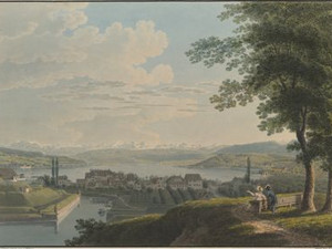
"The location of Zurich is incomparable; the serene city on the deep blue, crystal-clear lake, whose lively, gently rising shores are dotted with stately homes, orchards and vineyards as far as the eye can see, with the ridge of the Albis on the right and the snow-capped Glarus Alps, Glärnisch, Tödi, Clariden, then Achsenburg, Rossberg and the Uri-Rothstock near Altorf in the background. It is precisely this charming location that makes a stay in Zurich so attractive."

"The best place in Zurich to have a beautiful view of the lake is a terrace on the new promenade and the bastion called the Cat. [...] From here you can see a large part of the lake, the Albis chain, the Glärnisch, the Mieseren, the Myten and other high mountains whose peaks are covered with eternal snow."


Ort auf moderner Karte
GEOMETRYCOLLECTION (POINT (8.533512 47.371069), LINESTRING (8.533512 47.371069, 8.534038 47.369613))
Camera Settings (3D)
{"landscape":{"image.scale":28,"viewpoint":{"bounds":[[8.439495652046105,47.37118422208624],[8.590594366467315,47.470123434080165]],"bearing":163.08803536877622,"pitch":85,"zoom":18.059361112448627,"center":{"lng":8.534514158964157,"lat":47.36883595309422},"cam":{"center":{"lng":8.57114036893742,"lat":47.4248940892752},"zoom":11.817752854368257,"bearing":0},"cameraToCenterDistance":1918.5,"cameraPosition":{"lngLat":{"lng":8.533083039574251,"lat":47.37202368403888},"altitude":450.61518921487783},"cameraTargetElevation":418.2012084961244}},"portrait":{"viewpoint":{"bounds":[[8.439495653142302,47.371184222086896],[8.590594365791958,47.470123432922236]],"bearing":163.08803536877622,"pitch":85,"zoom":18.059361112448627,"center":{"lng":8.534514158963248,"lat":47.368835953094845},"cameraToCenterDistance":1918.5,"cameraPosition":{"lngLat":{"lng":8.533083039573313,"lat":47.372023684039505},"altitude":450.61518921487743},"cameraTargetElevation":418.2012084961244},"image.scale":28},"square":{"viewpoint":{"bounds":[[8.439495651975705,47.37118422208576],[8.590594366460607,47.470123434135616]],"bearing":163.08803536877622,"pitch":85,"zoom":18.059361112448627,"center":{"lng":8.53451415896302,"lat":47.368835953093964},"cam":{"center":{"lng":9.19498922440016,"lat":47.47176972700183},"zoom":8.21828980479871,"bearing":0},"cameraToCenterDistance":1918.5,"cameraPosition":{"lngLat":{"lng":8.533083039573171,"lat":47.372023684038595},"altitude":450.615189214878},"cameraTargetElevation":418.2012084961244},"image.scale":28}}
Quellen

Karl Baedeker, Die Schweiz. Handbüchlein für Reisende, nach eigener Anschauung und den besten Hülfsquellen bearbeitet, Koblenz 1844, p. 58; Jean-Louis-Antoine Reynier, Guide des Voyageurs en Suisse, Brussels 1821, pp. 21-22

Bilder
nb-481637
Ort
GEOMETRYCOLLECTION (POINT (8.551834 47.35337), LINESTRING (8.551834 47.35337, 8.550804 47.355449))
Titel
View of Zurich from the Zürichhorn
Text

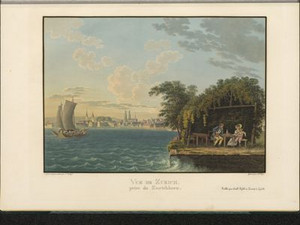
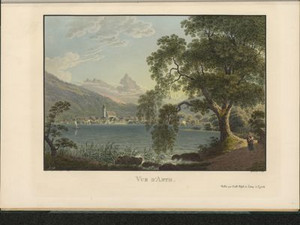
The text accompanying this view describes the walks along the shores of Lake Zurich in Seefeld as the most beautiful in Zurich. From this shore you can see part of the city of Zurich as well as the Grossmünster in the old town of Zurich.
"Zurich is built on both banks of the Limmat, which not only provides the city with the most beautiful water in the world, but also purifies and clears the city through the rapid breeze it creates on its way. [...] Of the two parts of the city, that which rises on the right bank of the river is the larger and, I believe, also the older; one finds there, amidst the buildings of all ages, all traces of the original soil; and in a just feedback, time has there respected the work of man scarcely less than he has respected the work of nature."


Ort auf moderner Karte
GEOMETRYCOLLECTION (POINT (8.550509 47.353051), LINESTRING (8.550509 47.353051, 8.54943 47.354647))
Camera Settings (3D)
{"landscape":{"image.scale":45,"viewpoint":{"bounds":[[8.476674943626762,45.59211867901482],[10.397357101662806,47.3522216700903]],"bearing":-30.947794899521117,"pitch":85,"zoom":17.876756819482644,"center":{"lng":8.548893838990352,"lat":47.35484843129558},"cam":{"center":{"lng":10.417534370976597,"lat":46.55425726094512},"zoom":7.690161564995987,"bearing":0},"cameraToCenterDistance":2386.6464914402973,"cameraPosition":{"lngLat":{"lng":8.552465785294658,"lat":47.35081266932002},"altitude":450.2765625496586},"cameraTargetElevation":404.5},"camera.fov":30},"portrait":{"viewpoint":{"bounds":[[8.476674942142466,45.59211868004604],[10.397357100067495,47.35222167009073]],"bearing":-30.947794899521117,"pitch":85,"zoom":17.876756819482644,"center":{"lng":8.548893838987851,"lat":47.354848431296716},"cameraToCenterDistance":2386.6464914402973,"cameraPosition":{"lngLat":{"lng":8.5524657852921,"lat":47.35081266932116},"altitude":450.2765625496576},"cameraTargetElevation":404.5},"image.scale":45},"square":{"viewpoint":{"bounds":[[8.476674942171513,45.59211867992019],[10.397357100590796,47.352221670089506]],"bearing":-30.947794899521117,"pitch":85,"zoom":17.876756819482644,"center":{"lng":8.548893838990125,"lat":47.35484843129541},"cam":{"center":{"lng":18.080085734267783,"lat":47.13657661050274},"zoom":4.550234300080729,"bearing":0},"cameraToCenterDistance":2386.6464914402973,"cameraPosition":{"lngLat":{"lng":8.552465785294402,"lat":47.35081266931985},"altitude":450.27656254965876},"cameraTargetElevation":404.5},"image.scale":45}}
Quellen

Voyage pittoresque aux lacs de Zurich, Zoug, Lowerz, Egeri et Wallenstadt, Zurich 1819, p. 25; Désiré Raoul-Rochette, Lettres sur la Suisse, écrites en 1820, suivies d'un Voyage à Chamouny et au Simplon, Paris 1822, p. 265

Bilder
nb-481638
Ort
GEOMETRYCOLLECTION (POINT (8.731771 47.200211), LINESTRING (8.731771 47.200211, 8.715262 47.205277))
Titel
View of Richterswil
Text

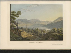
"Goods bound for Italy are unloaded here and transported on the Axe to Brunnen on Lake Lucerne. The lake is at its widest here, and the views from its shores and while cruising on it are extraordinarily beautiful, extensive and varied."
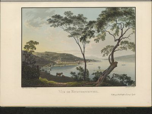
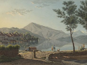
From this vantage point above Bäch SZ, there is a view of the bay of Richterswil and the shores of Lake Zurich as far as Wollishofen and to the right of Stäfa as far as Meilen.


Ort auf moderner Karte
GEOMETRYCOLLECTION (POINT (8.725795 47.199205), LINESTRING (8.725795 47.199205, 8.725435 47.199388))
Camera Settings (3D)
{"landscape":{"viewpoint":{"bounds":[[8.476759985667059,47.197596322262],[8.728418440351021,47.37518285205468]],"bearing":-63.78625857719993,"pitch":81.49999999999999,"zoom":17.255988831644736,"center":{"lng":8.72213065625374,"lat":47.2004911542285},"cam":{"center":{"lng":8.703019328877673,"lat":47.29403302560786},"zoom":10.977514239114315,"bearing":0},"cameraToCenterDistance":1918.5,"cameraPosition":{"lngLat":{"lng":8.729777700589722,"lat":47.1979329581408},"altitude":505.44783543297797},"cameraTargetElevation":409.20693362073365}},"portrait":{"viewpoint":{"bounds":[[8.476759984225112,47.19759632222207],[8.728418440352954,47.37518285231474]],"bearing":-63.78625857719993,"pitch":81.49999999999999,"zoom":17.255988831644736,"center":{"lng":8.722130656255104,"lat":47.2004911542289},"cameraToCenterDistance":1918.5,"cameraPosition":{"lngLat":{"lng":8.729777700591171,"lat":47.19793295814122},"altitude":505.4478354329773},"cameraTargetElevation":409.20693362073365}},"square":{"viewpoint":{"bounds":[[8.476759982544195,47.1975963222346],[8.728418440353352,47.375182854282485]],"bearing":-63.78625857719993,"pitch":81.49999999999999,"zoom":17.255988831644736,"center":{"lng":8.72213065625499,"lat":47.200491154228985},"cam":{"center":{"lng":9.735052271590035,"lat":47.37174940741144},"zoom":7.482314106061328,"bearing":0},"cameraToCenterDistance":1918.5,"cameraPosition":{"lngLat":{"lng":8.729777700591029,"lat":47.19793295814125},"altitude":505.44783543297706},"cameraTargetElevation":409.20693362073365}}}
Quellen

Johann Gottfried Ebel, Anleitung, auf die nützlichste und genussvollste Art die Schweitz bereisen, vol. 4, Zurich 1810, p. 112; Voyage pittoresque aux lacs de Zurich, Zoug, Lowerz, Egeri et Wallenstadt, Zurich 1819, p. 26

Bilder
nb-481639
Ort
POINT (8.830282 47.234927)
Titel
View of Rapperswil from the Meienberg
Text

Click on "Open image details" for more information.

Ort auf moderner Karte
GEOMETRYCOLLECTION (POINT (8.830272 47.234943), LINESTRING (8.830272 47.234943, 8.830111 47.234858))
Camera Settings (3D)
{"landscape":{"image.scale":50,"viewpoint":{"bounds":[[8.832263328227128,47.220077054309826],[9.381674267120218,47.524290173193236]],"bearing":-125.97634341731326,"pitch":84.02717169343356,"zoom":18.35478872662832,"center":{"lng":8.830272000000036,"lat":47.23494300000468},"cam":{"center":{"lng":9.27928990198518,"lat":47.385368163606074},"zoom":10.198606792193294,"bearing":0},"cameraToCenterDistance":1918.5,"cameraPosition":{"lngLat":{"lng":8.833510740755116,"lat":47.236539317578774},"altitude":501.90736883398995},"cameraTargetElevation":470.2937500000015}},"portrait":{"viewpoint":{"bounds":[[8.832263328227697,47.22007705409658],[9.38167427688444,47.52429017828197]],"bearing":-125.97634341731326,"pitch":84.02717169343356,"zoom":18.35478872662832,"center":{"lng":8.830272000000718,"lat":47.23494300000496},"cameraToCenterDistance":1918.5,"cameraPosition":{"lngLat":{"lng":8.833510740755912,"lat":47.23653931757903},"altitude":501.9073688339898},"cameraTargetElevation":470.2937500000015}},"square":{"viewpoint":{"bounds":[[8.832263328228123,47.22007705367196],[9.381674288364081,47.52429018431391]],"bearing":-125.97634341731326,"pitch":84.02717169343356,"zoom":18.35478872662832,"center":{"lng":8.830272000000605,"lat":47.23494300000482},"cam":{"center":{"lng":11.579318128908056,"lat":47.55811380579351},"zoom":6.35589550035892,"bearing":0},"cameraToCenterDistance":1918.5,"cameraPosition":{"lngLat":{"lng":8.833510740755798,"lat":47.23653931757892},"altitude":501.90736883398984},"cameraTargetElevation":470.2937500000015}}}
Bilder
nb-481640
Ort
POINT (8.513071 47.170344)
Titel
View from Zug in the direction of the Rigi
Text

Goethe was one of the first travelers to climb Mount Rigi in 1775 to enjoy the view. After experiencing billowing wisps of mist that repeatedly revealed scattered views of the landscape, he wrote: "It was a unique spectacle that has never been seen before and will never be repeated". 
The ascent on foot to the Rigi began in Arth, which was reached by boat from Zug. Rigi-Kulm was reached on horseback via the Kuhhirten mountain road from Lauerz. In both cases, the ascent to Rigi-Klösterli took three hours.


Ort auf moderner Karte
GEOMETRYCOLLECTION (POINT (8.513952 47.167106), LINESTRING (8.513952 47.167106, 8.506498 47.155646))
Camera Settings (3D)
{"landscape":{"viewpoint":{"bounds":[[8.462944589805602,47.16946665538305],[8.851648210443557,47.40774606318885]],"bearing":-162.16790415512722,"pitch":84.99544763028395,"zoom":16.69513318540472,"center":{"lng":8.51194783879032,"lat":47.16328295531207},"cam":{"center":{"lng":8.792055816623758,"lat":47.298895994977244},"zoom":10.553320105863538,"bearing":0},"cameraToCenterDistance":1918.5,"cameraPosition":{"lngLat":{"lng":8.515826174996079,"lat":47.17147960281119},"altitude":496.8468173843207},"cameraTargetElevation":413},"image.scale":87},"portrait":{"viewpoint":{"bounds":[[8.462944589961523,47.169466655382365],[8.851648209483926,47.40774606251017]],"bearing":-162.16790415512722,"pitch":84.99544763028395,"zoom":16.69513318540472,"center":{"lng":8.511947838791002,"lat":47.1632829553115},"cameraToCenterDistance":1918.5,"cameraPosition":{"lngLat":{"lng":8.51582617499679,"lat":47.17147960281059},"altitude":496.8468173843216},"cameraTargetElevation":413},"image.scale":76},"square":{"viewpoint":{"bounds":[[8.462944589851446,47.16946665538072],[8.85164821047502,47.40774606319914]],"bearing":-162.16790415512722,"pitch":84.99544763028395,"zoom":16.69513318540472,"center":{"lng":8.511947838791002,"lat":47.16328295530985},"cam":{"center":{"lng":10.406462692969257,"lat":47.4204058985473},"zoom":6.855110645332235,"bearing":0},"cameraToCenterDistance":1918.5,"cameraPosition":{"lngLat":{"lng":8.51582617499676,"lat":47.171479602809},"altitude":496.84681738432414},"cameraTargetElevation":413},"image.scale":76}}
Quellen

Voyage pittoresque aux lacs de Zurich, Zoug, Lowerz, Egeri et Wallenstadt, Zürich 1819, p. 31; https://www.stadtzug.ch/fpzuginzahlen [16.3.2023]; http://www.goethezeitportal.de/wissen/illustrationen/johann-wolfgang-von-goethe/goethes-erste-schweizer-reise-von-1775.html [30.03.2023]; Johann Gottfried Ebel, Anleitung, auf die nützlichste und genussreichste Art die Schweitz zu bereisen, vol. 4, Zurich 1810, p. 117

Bilder
nb-481641
Ort
POINT (8.508647 47.068134)
Titel
View over Lake Zug to Arth and the Mythen mountains
Text

Arth was a popular place for travelers on their way to Mount Rigi: "Of the huge throng of travelers going up Mount Rigi, there are few who do not stop here before or after they have climbed the mountain. [...] You can find horses and even chairs here to be carried up the mountain on the back of a man."


Ort auf moderner Karte
GEOMETRYCOLLECTION (POINT (8.511188 47.065072), LINESTRING (8.511188 47.065072, 8.519973 47.062171))
Camera Settings (3D)
{"landscape":{"image.scale":27,"viewpoint":{"bounds":[[8.509693055886345,46.98289587763986],[8.634379104712139,47.07708538241374]],"bearing":108.65918680946515,"pitch":82.80420918367345,"zoom":19.35834229834464,"center":{"lng":8.511209785967822,"lat":47.06509680851693},"cam":{"center":{"lng":8.625046389968446,"lat":47.03402599338844},"zoom":11.899361319149826,"bearing":0},"cameraToCenterDistance":1918.5,"cameraPosition":{"lngLat":{"lng":8.509323230621447,"lat":47.065530755293196},"altitude":435.79041765948386},"cameraTargetElevation":416.7487304688653}},"portrait":{"viewpoint":{"bounds":[[8.509693100709285,46.98300918561634],[8.634207936064172,47.077069485001005]],"bearing":108.65918681073593,"pitch":82.8028826278891,"zoom":19.358338080744108,"center":{"lng":8.511209785968049,"lat":47.065096808517694},"cameraToCenterDistance":1918.5,"cameraPosition":{"lngLat":{"lng":8.509323230621703,"lat":47.06553075529402},"altitude":435.7939652219337},"cameraTargetElevation":416.7487304688653},"image.scale":27},"square":{"viewpoint":{"bounds":[[8.50969310070937,46.98300917847246],[8.634207946706539,47.07706948594898]],"bearing":108.65918681073593,"pitch":82.8028826278891,"zoom":19.358338080744108,"center":{"lng":8.511209785968504,"lat":47.06509680851809},"cam":{"center":{"lng":9.1322673306953,"lat":47.07247874982343},"zoom":8.49746342507144,"bearing":0},"cameraToCenterDistance":1918.5,"cameraPosition":{"lngLat":{"lng":8.50932323062213,"lat":47.06553075529442},"altitude":435.7939652219336},"cameraTargetElevation":416.7487304688653},"image.scale":28}}
Quellen

Voyage pittoresque aux lacs de Zurich, Zoug, Lowerz, Egeri et Wallenstadt, Zurich 1819, p. 13; Franz Auf der Maur, "Mythen", in: Historisches Lexikon der Schweiz (HLS), version of 22.06.2009 [16.3.2023]

Bilder
nb-481642
Titel
View of the Rigi from Lowerzsee
Text

Click on "Open image details" for more information.

Aufnahmestandort
nb-481642
Ort auf moderner Karte
GEOMETRYCOLLECTION (POINT (8.624122 47.028887), LINESTRING (8.624122 47.028887, 8.616836 47.029263))
Camera Settings (3D)
{"landscape":{"viewpoint":{"bounds":[[8.627248114838352,46.97153759041174],[8.729528279739355,47.05881946768119]],"bearing":-87.05084962203756,"pitch":85,"zoom":18.360398011676743,"center":{"lng":8.624121999990848,"lat":47.02888699999724},"cam":{"center":{"lng":8.710420005916319,"lat":47.01762290932365},"zoom":12.626129027550654,"bearing":0},"cameraToCenterDistance":1918.5,"cameraPosition":{"lngLat":{"lng":8.628109791735739,"lat":47.02874696405772},"altitude":507.7705124716022},"cameraTargetElevation":481.2919870046911}},"portrait":{"viewpoint":{"bounds":[[8.623962861624562,46.977746619813615],[8.6874227439082,47.05256218861655]],"bearing":-82.57251052125383,"pitch":85,"zoom":16.839113415779746,"center":{"lng":8.617615699768066,"lat":47.02952084880755},"cameraToCenterDistance":1282.6385684316433,"cameraPosition":{"lngLat":{"lng":8.625214471411539,"lat":47.028845619690884},"altitude":497.3140049619192},"cameraTargetElevation":446.5000000000018},"camera.fov":53,"image.scale":22},"square":{"viewpoint":{"bounds":[[8.60068241526912,47.01614146112297],[8.62568452934488,47.047171172517665]],"bearing":-92.65084962203751,"pitch":77.49999999999999,"zoom":19.97008597802969,"center":{"lng":8.625062853097916,"lat":47.02880371245769},"cam":{"center":{"lng":8.72569298564784,"lat":47.0401785391021},"zoom":10.81365919771099,"bearing":0},"cameraToCenterDistance":1282.6385684316433,"cameraPosition":{"lngLat":{"lng":8.625919217236685,"lat":47.02883073834346},"altitude":503.45245455754},"cameraTargetElevation":489.047451783985},"image.scale":32}}
Bilder
nb-481643
Titel
View of Lake Aegeri
Text

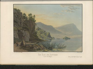
"I only stopped at Egeri to look at a little-known lake, although its shape and setting make it one of the most picturesque in Switzerland. Its oval basin stretches to the foot of the bare, reddish rocks of the Kaiserstock and Rossberg, which border it to the southwest. The other bank rises like an amphitheater over a gentle, green slope and ends on the Morgarten plateau. To the south, the mountains approach in a wild manner and fall away steeply, so that only the snow-capped peaks of Ury and Unterwald can be seen above the high walls of Figlerflue and the saddle; and the purity and beautiful green color of the lake water form a mirror in the midst of this melancholy landscape, destined to reflect alternately the imposing and graceful images."

Aufnahmestandort
nb-481643
Ort auf moderner Karte
GEOMETRYCOLLECTION (POINT (8.608935 47.137996), LINESTRING (8.608935 47.137996, 8.609922 47.136536))
Camera Settings (3D)
{"landscape":{"viewpoint":{"bounds":[[8.562174530391843,47.06807966382388],[8.689348468836101,47.13928340761362]],"bearing":153.941411612122,"pitch":79.52708735828472,"zoom":19.652242628763776,"center":{"lng":8.608411699533463,"lat":47.13872553586043},"cam":{"center":{"lng":8.665890743849957,"lat":47.10672834475716},"zoom":12.300980301806122,"bearing":0},"cameraToCenterDistance":1282.6385684316433,"cameraPosition":{"lngLat":{"lng":8.607938899222887,"lat":47.139383224043854},"altitude":791.3812230957628},"cameraTargetElevation":776.3330200197245}},"portrait":{"camera.fov":41,"viewpoint":{"bounds":[[8.597005619831691,47.113013382903006],[8.636192014112396,47.139405778605976]],"bearing":153.941411612122,"pitch":79.52708735828472,"zoom":19.652242628763776,"center":{"lng":8.608411699534258,"lat":47.13872553586009},"cameraToCenterDistance":1710.4204453662037,"cameraPosition":{"lngLat":{"lng":8.607781212242173,"lat":47.13960257248041},"altitude":796.4000559258341},"cameraTargetElevation":776.3330200197245}},"square":{"viewpoint":{"bounds":[[8.597005619852098,47.1130133827935],[8.636192014277952,47.13940577860595]],"bearing":153.941411612122,"pitch":79.52708735828472,"zoom":19.652242628763776,"center":{"lng":8.608411699532553,"lat":47.13872553585992},"cam":{"center":{"lng":8.792937591981257,"lat":47.13954047793001},"zoom":10.165356450680967,"bearing":0},"cameraToCenterDistance":1710.4204453662037,"cameraPosition":{"lngLat":{"lng":8.607781212240582,"lat":47.139602572480214},"altitude":796.4000559258342},"cameraTargetElevation":776.3330200197245}}}
Quellen

Désiré Raoul Rochette, Lettres sur la Suisse, écrites en 1820, suivies d'un voyage à Chamouny et au Simplon, Paris 1822, pp. 100 - 101

Bilder
nb-481644
Titel
View of Wesen
Text

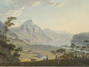
Since the middle of the 18th century, the debris from the Linth had increasingly dammed up the Maag, the only outflow from Lake Walen at the time, and turned the area between Lake Walen and Lake Zurich into a swamp. This situation was remedied from 1804: Under the direction of the Zurich engineer Hans Konrad Escher (1767-1823), the Linth coming from the Glarnerland was diverted into Lake Walen, where it could deposit its debris and the outflow from Lake Walen to Lake Zurich was canalized. It was one of the Confederation's major identity-building projects during the difficult period of mediation, when the political cohesion of the cantons was constantly under threat. The work was largely completed in 1823.


Aufnahmestandort
nb-481644
Ort auf moderner Karte
GEOMETRYCOLLECTION (POINT (9.06922 47.132769), LINESTRING (9.06922 47.132769, 9.06945 47.132769))
Camera Settings (3D)
{"landscape":{"image.scale":33,"viewpoint":{"bounds":[[8.982001550181906,47.09984901782872],[9.06713535816013,47.18121354171339]],"bearing":88.3984897802211,"pitch":84.13135952229081,"zoom":18.804087403387562,"center":{"lng":9.069168269621741,"lat":47.13276909841338},"cam":{"center":{"lng":9.070455920683287,"lat":47.144014815706356},"zoom":12.107534131071446,"bearing":0},"cameraToCenterDistance":1710.4204453662037,"cameraPosition":{"lngLat":{"lng":9.066555571471042,"lat":47.13271940357711},"altitude":586.1447696529608},"cameraTargetElevation":565.8219726417283}},"portrait":{"image.scale":35,"viewpoint":{"bounds":[[8.981988545901032,47.09984396845471],[9.067135369703266,47.18122098445335]],"bearing":88.39848977817202,"pitch":84.13120246160133,"zoom":18.804086996878837,"center":{"lng":9.069168269619468,"lat":47.13276909841309},"cameraToCenterDistance":1710.4204453662037,"cameraPosition":{"lngLat":{"lng":9.06655557146874,"lat":47.132719403576715},"altitude":586.1453173690244},"cameraTargetElevation":565.8219726417283}},"square":{"image.scale":16,"viewpoint":{"bounds":[[8.42466782936495,46.882091760216326],[9.072540233146526,47.50067740881758]],"bearing":88.39848977890733,"pitch":84.13135952229479,"zoom":15.876181755313082,"center":{"lng":9.088010787963867,"lat":47.133125828340155},"cam":{"center":{"lng":11.664029848272861,"lat":47.411957045148},"zoom":6.11807148390584,"bearing":0},"cameraToCenterDistance":1710.4204453662037,"cameraPosition":{"lngLat":{"lng":9.068128028324196,"lat":47.13274764959428},"altitude":578.5970584777396},"cameraTargetElevation":423.9406249999015}}}
Quellen

Johann Gottfried Ebel, Anleitung, auf die nützlichste und genussvollste Art die Schweiz zu bereisen, vol. 4, Zurich 1810, p. 492; https://www.linthwerk.ch/index.php/geschichte/nationalunternehmung [04.03.2024]; https://hans-konrad-escher.ch/ [04.03.2024]

Bilder
nb-481645
Titel
View of Walenstadt
Text

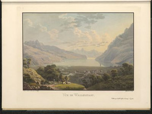
Before the Linth plant was completed, Walenstadt was also affected by the constant flooding: "[Walenstadt] lies a quarter of an hour from Lake Wallenstadt in a swampy, extremely unhealthy area. All the roads on the lake side are covered in mud, and people crawl on planks along the dilapidated houses."


Aufnahmestandort
nb-481645
Ort auf moderner Karte
GEOMETRYCOLLECTION (POINT (9.334268 47.123853), LINESTRING (9.334268 47.123853, 9.333605 47.123802))
Camera Settings (3D)
{"landscape":{"image.scale":19,"viewpoint":{"bounds":[[9.245077749165773,47.092120510548],[9.334995949778033,47.201799982212975]],"bearing":-78.62365654036965,"pitch":78.64334662666397,"zoom":19.465200588714616,"center":{"lng":9.334090054031549,"lat":47.12384459759528},"cam":{"center":{"lng":9.35190070214091,"lat":47.151663311481656},"zoom":11.676537605212433,"bearing":0},"cameraToCenterDistance":1177.8124816183965,"cameraPosition":{"lngLat":{"lng":9.335189804474169,"lat":47.12369403759783},"altitude":672.6976063880544},"cameraTargetElevation":655.6509277103022},"camera.fov":57},"portrait":{"image.scale":16,"viewpoint":{"bounds":[[9.245077749175834,47.09212051062565],[9.334995949779056,47.20179998226865]],"bearing":-78.62365654036965,"pitch":78.64334662666397,"zoom":19.465200588714616,"center":{"lng":9.334090054032686,"lat":47.12384459759477},"cameraToCenterDistance":1177.8124816183965,"cameraPosition":{"lngLat":{"lng":9.335189804475249,"lat":47.12369403759729},"altitude":672.6976063880545},"cameraTargetElevation":655.6509277103022}},"square":{"image.scale":16,"viewpoint":{"bounds":[[9.245077742386712,47.092120508155745],[9.334995949780733,47.20179998828553]],"bearing":-78.62365654036965,"pitch":78.64334662666397,"zoom":19.465200588714616,"center":{"lng":9.33409005403405,"lat":47.12384459759528},"cam":{"center":{"lng":9.694668779356732,"lat":47.17755732258402},"zoom":8.967096011772862,"bearing":0},"cameraToCenterDistance":1177.8124816183965,"cameraPosition":{"lngLat":{"lng":9.335189804476698,"lat":47.12369403759783},"altitude":672.6976063880544},"cameraTargetElevation":655.6509277103022}}}
Quellen

Johann Gottfried Ebel, Anleitung, auf die nützlichste und genussvollste Art die Schweitz zu bereisen, vol. 4, Zurich 1810, p. 461

Johann Gottfried Ebel, Anleitung, auf die nützlichste und genussvollste Art die Schweitz zu bereisen, vol. 3, Zurich 1810, p. 363; Johann Gottfried Ebel, Anleitung, auf die nützlichste und genussvollste Art die Schweitz zu bereisen, vol. 4, Zurich 1810, p. 465; Johann Gottfried Ebel, Anleitung, auf die nützlichste und genussvollste Art die Schweitz zu bereisen, vol. 4, Zurich 1810, p. 588; Rebecca Gericke-Budliger: "Johann Jakob Wetzel". In: SIKART Lexikon zur Kunst in der Schweiz, 2019 (first published in 1998) [23.02.2024] ; Paola von Wyss-Giacosa: "Franz Hegi". In: SIKART Lexikon zur Kunst in der Schweiz, 2017 (first published in 1998). [03.05.2024]

Download the entire document as PDF

Bitte berühren!