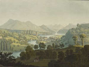
The view of Lucerne from the Zimmeregg shows the city's location at the outflow of the Reuss from Lake Lucerne. The two unequal parts of the old town are connected by four bridges, including the famous Chapel Bridge. It dates back to 1332 and has become one of Lucerne's landmarks. It was devastated by fire in 1993, but was rebuilt true to the original a year later. On the hills to the left we see the Museggmauer, an important remnant of the medieval city fortifications. The panorama of the Central Swiss Alps opens up in the background, with the Rigi on the left edge of the picture. At the time of this picturesque journey, in 1817, Lucerne had a population of around 4500. The city served as a starting point for travelers visiting Central Switzerland and also as a stopover on the way to the Gotthard Pass and Italy.
Voyage pittoresque au lac des Waldstettes ou des IV cantons 1817, vue de Lucerne; https://kapellbruecke.com/ [20.06.2023]; Markus Lischer; Ebbe Nielsen; Hermann Fetz; Konrad Wanner; Markus Trüeb, "Luzern (municipality)", in: Historisches Lexikon der Schweiz (HLS), version of 03.11.2016 [09.02.2024]
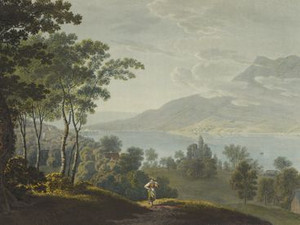
"One can also walk from Lucerne through the village of Meggen and Mörlischach in 3 hours on a path that is exceptionally rich in views. Here one passes close to the ruins of Neu-Habsburg Castle on the Rame-Flue hill, where above the village of Meggen there is a magnificent viewpoint overlooking the entire lake landscape."
Johann Gottfried Ebel, Anleitung, auf die nützlichste und genussvollste Art die Schweitz zu bereisen, vol. 3, Zurich 1810, p. 410
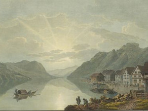
The use of Lake Lucerne as a transport route was not limited to the large-scale transportation of goods on the Gotthard route. Most of the neighboring cantons also communicated via the fast waterway. This included the municipality of Horw and the Lucerne region, which sent their ships from the hamlet of Winkel (LU) in the direction of Unterwalden. This place was an important transshipment point for cattle transportation. The group of buildings comprising the customs house and Dreikönigskapelle chapel bear witness to the importance of the port.
Waltraud Hörsch, "Winkel (LU)", in: Historisches Lexikon der Schweiz (HLS), version of 02.05.2013 [09.02.2024]; https://www.horw.ch/winkel [09.02.2024]
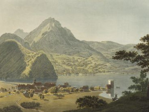
"Alpnach, in the canton of Unterwalden, on a melancolic bay of Lake Lucerne and at the mouth of the Melchbach, which carries the outflows of the lakes of Obwalden."
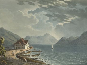
The port of Alpnachstad also had a certain importance for regional traffic - but shipping could become quite uncomfortable during a Föhn storm, as this view shows.
Johann Gottfried Ebel, Anleitung, auf die nützlichste und genussvollste Art die Schweitz bereisen, vol. 2, Zurich 1810, p. 64; Voyage pittoresque au lac des Waldstettes ou des IV cantons, Zurich 1817, no p.
"This small town, with its scattered houses covering a gracefully shaped bay, seems to smile at the stranger who enters it. But these houses stand amidst ruins, and these ruins are not of the kind that age produces. A single house, bearing the venerable seal of time, impresses by its immaculate character, and contrasts with the sad ruins that surround it."
On this view, there is nothing to suggest the severe destruction suffered by Stansstad and numerous other villages in September 1798, when French troops brutally crushed the uprising against the Helvetic central state, which was supported by large sections of the Nidwalden population.
Désiré Raoul Rochette, Lettres sur la Suisse, Paris 1828, p. 115; Peter Steiner; Hansjakob Achermann; Emil Weber; Karin Schleifer-Stöckli; Fabian Hodel, "Nidwalden", in: Historisches Lexikon der Schweiz (HLS), version of 11.05.2017 [29.07.2024]
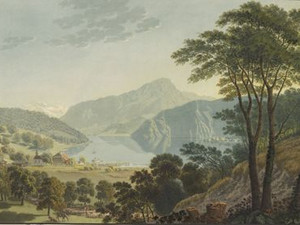
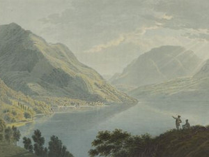
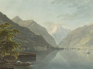
This view was taken from the small harbor of Beckenried, a village in Unterwalden, and shows most of the Gulf of Brunnen, which is crowned by an imposing mountain range. The south side of the Rigi, the Hohflue, Schwand and Brunniberg as well as the small and large Mythen can be seen from the left.
Voyage pittoresque au lac des Waldstettes ou des IV cantons, Zurich 1817, Vue prise de Beckenried vers Schwytz
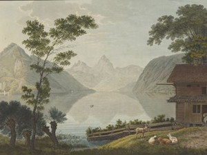
"Gersau, a well-built village of 82 houses and about 800 inhabitants, in the canton of Schwyz. It is beautifully situated in a small plain surrounded by a mountain slope, at the south-western foot of the Rigi and on the eastern shore of Lake Lucerne. A new, handsome parish church and several decent houses adorn the village. In addition to livestock farming, the inhabitants live from the production of silk and handicrafts."
In 1390, Gersau bought itself out of Habsburg rule and from then on formed its own republic until 1798. This special legal status for a village community is repeatedly mentioned in the travel literature of the early 19th century.
Robert Glutz-von Blotzheim, Handbuch für Reisende in der Schweiz, 5th edition, Zurich 1823, p. 216; Albert Müller, "Gersau", in: Historisches Lexikon der Schweiz (HLS), version of 08.12.2006 [16.02.2024]
Click on "Open image details" for more information.
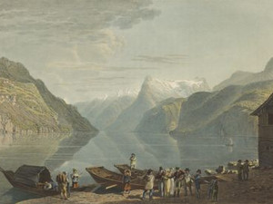
"This place has a very lively shipping trade on all sides, especially to Altorf, the trade route over the Gothard; that is why there is a large merchandise settlement here. Shipping is carried out in turn among the skippers and has a certain legal price."
Johann Gottfried Ebel, Anleitung, auf die nützlichste und genussvollste Art die Schweiz zu bereisen, vol. 2, Zurich 1809, p. 310
Flüelen was the actual gateway to Uri, as the vast majority of travelers and goods came by boat from Brunnen or Lucerne. Before the introduction of steamboats on Lake Lucerne in 1837, the journey from Lucerne by rowing or sailing boat took a good nine hours; this journey time was now reduced to two hours. It also served as a port for the nearby main town of Altdorf. This was the end of the sea route and the beginning of the Gotthard road. With the opening of the Axenstrasse in 1865, Flüelen suddenly lost all significance in terms of transportation.
Johann Jakob Wetzel, Voyage pittoresque au lac des Waldstettes ou des IV cantons, Zurich 1817, pp. 7-8; Rebecca Gericke-Budliger: "Johann Jakob Wetzel". In: SIKART Lexikon zur Kunst in der Schweiz, 2019 (first published in 1998) [23.02.2024]; Paola von Wyss-Giacosa: "Franz Hegi". In: SIKART Lexikon zur Kunst in der Schweiz, 2017 (first published in 1998). [03.05.2024]