EN Picturesque journey from Geneva to Milan over the Simplon, 1811

In Napoleon's footsteps over the Simplon
Bilder
nb-479854
Ort
GEOMETRYCOLLECTION (POINT (6.181276 46.215947), LINESTRING (6.181276 46.215947, 6.134766 46.200177))
Titel
Vue de Genève from Cologny
Text

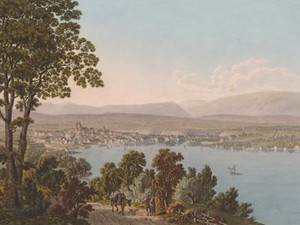
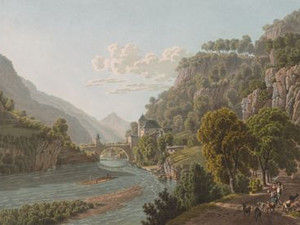
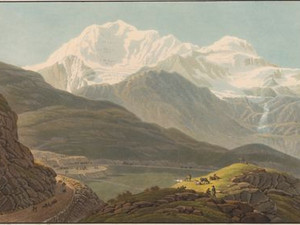
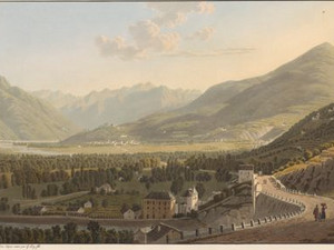
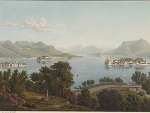
A settlement developed on the right bank of the Rhone as early as the Neolithic period. In Roman and early medieval times, people then lived on the left bank, where the view shows St-Pierre Cathedral on the highest point of the Cité hill.
Through the work of John Calvin from 1540, Geneva developed into a center of the Reformation and was also called "the reformed Rome". Although the city was only able to conclude alliances with Bern, Solothurn and Zurich in the later 16th century, Ebel tells us that it has always been regarded as a federal city. Around 1800, this made Geneva the largest city in Switzerland with around 25,000 inhabitants - more than twice as many as Zurich.


Aufnahmestandort
nb-479854
Ort auf moderner Karte
GEOMETRYCOLLECTION (POINT (6.180158 46.215324), LINESTRING (6.180158 46.215324, 6.179767 46.215179))
Camera Settings (3D)
{"landscape":{"viewpoint":{"bounds":[[4.995099378746346,45.61975512752207],[6.180008763403038,46.36897274828061]],"bearing":-117.90494513563117,"pitch":83,"zoom":16.63137060075325,"center":{"lng":6.170614957825364,"lat":46.21184584562525},"cam":{"center":{"lng":6.001267192803482,"lat":46.027557311463084},"zoom":8.935075476437913,"bearing":0},"cameraToCenterDistance":1918.5,"cameraPosition":{"lngLat":{"lng":6.182270189015242,"lat":46.21611695347542},"altitude":492.7982981025224},"cameraTargetElevation":368.19335937499966},"image.scale":50},"portrait":{"viewpoint":{"bounds":[[6.178239963684746,45.965583314744606],[8.112241971039111,47.17224176790759]],"bearing":-117.90494513563117,"pitch":84,"zoom":16.63137060075325,"center":{"lng":6.170614957824341,"lat":46.21184584562704},"cameraToCenterDistance":1918.5,"cameraPosition":{"lngLat":{"lng":6.182293389698515,"lat":46.21612545513304},"altitude":475.068168057997},"cameraTargetElevation":368.19335937499966},"image.scale":36},"square":{"viewpoint":{"bounds":[[6.178239963683865,45.965583312443016],[8.112241987631847,47.17224177594281]],"bearing":-117.90494513563117,"pitch":84,"zoom":16.63137060075325,"center":{"lng":6.170614957823773,"lat":46.211845845625334},"cam":{"center":{"lng":15.84825008342375,"lat":47.23295051658425},"zoom":4.540263791722689,"bearing":0},"cameraToCenterDistance":1918.5,"cameraPosition":{"lngLat":{"lng":6.182293389697946,"lat":46.21612545513133},"altitude":475.06816805800037},"cameraTargetElevation":368.19335937499966},"image.scale":37},"null":{"image.scale":81,"viewpoint":{"bounds":[[6.055043779939865,46.146538358595706],[6.18125547775395,46.25022780262253]],"bearing":-121.10494513562456,"pitch":84.02716473861663,"zoom":15.704445637395944,"center":{"lng":6.171398162842024,"lat":46.21166023807234},"cam":{"center":{"lng":6.150034708092932,"lat":46.19840753907371},"zoom":12.320808814406751,"bearing":0},"cameraToCenterDistance":943.9676901250382,"cameraPosition":{"lngLat":{"lng":6.181983459761483,"lat":46.21607963664346},"altitude":470.02697955708},"cameraTargetElevation":370.4999999998133}}}
Quellen

Martine Piguet, Jean Terrier, Charles Bonnet, HLS DHS DSS, Liliane Mottu-Weber, Irène Herrmann, Charles Heimberg, "Geneva (municipality)", in: Historisches Lexikon der Schweiz (HLS), version of 07.02.2018, translated from the French [17.06.2024]; Martine Piguet, Jean Terrier, HLS DHS DSS, Liliane Mottu-Weber, Irène Herrmann, Charles Heimberg, "Geneva (canton)", in: Historical Dictionary of Switzerland (HLS), version of 30.05.2017, translated from French [17.06.2024]; Johann Gottfried Ebel, Anleitung, auf die nützlichste und genussvollste Art die Schweiz zu bereisen, vol. 2, Zurich 1810, p. 35

Bilder
nb-479855
Ort
GEOMETRYCOLLECTION (POINT (6.549574 46.393735), LINESTRING (6.549574 46.393735, 6.762806 46.510617))
Titel
Les Eaux d'Amphion, près d'Evian
Text

Once the border with the Kingdom of Savoy has been crossed, the traveler finds himself in an area that is very different from the Swiss Confederation - at least if you believe the accompanying text: 
"After leaving Cologny, the path moves away from the lakeshore and leads for seven lieues through poorly cultivated land, the small town of Thonon, the former capital of Chablais, and dreary villages where everything tells of the poverty of the inhabitants."
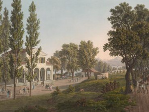
However, relief for the tourist tired by the monotonous route is already in sight: the elegant pavilion of the Baths of Amphion. Before neighboring Evian became a major spa town in 1823, Amphion was known for its iron-rich mineral springs. According to the accompanying text, the three reasons for the town's popularity are: its pleasant location, the beauty of its surroundings and the good company that gathers there.


Ort auf moderner Karte
GEOMETRYCOLLECTION (POINT (6.546631 46.394354), LINESTRING (6.546631 46.394354, 6.547058 46.394594))
Camera Settings (3D)
{"landscape":{"viewpoint":{"bounds":[[6.326219909771822,46.27859040370271],[6.547400287458316,46.406396812026486]],"bearing":56.19534801519558,"pitch":85,"zoom":17.56287972610552,"center":{"lng":6.551282107830048,"lat":46.396510549442525},"cam":{"center":{"lng":6.507830509183577,"lat":46.347978308165324},"zoom":11.477400586953616,"bearing":0},"cameraToCenterDistance":1918.5,"cameraPosition":{"lngLat":{"lng":6.545515050601438,"lat":46.39384742661127},"altitude":414.5650046165888},"cameraTargetElevation":368},"image.scale":26},"portrait":{"viewpoint":{"bounds":[[6.32622065184114,46.278590792652466],[6.547400300254907,46.40639677944168]],"bearing":56.19534801566272,"pitch":85,"zoom":17.562884486289416,"center":{"lng":6.551282107818679,"lat":46.39651054943434},"cameraToCenterDistance":1918.5,"cameraPosition":{"lngLat":{"lng":6.545515069618546,"lat":46.39384743539023},"altitude":414.5648509752418},"cameraTargetElevation":368},"image.scale":23},"square":{"viewpoint":{"bounds":[[6.326220653933689,46.27859079400358],[6.547400300254537,46.40639677930699]],"bearing":56.19534801566272,"pitch":85,"zoom":17.562884486289416,"center":{"lng":6.551282107818338,"lat":46.39651054943397},"cam":{"center":{"lng":7.432118885537932,"lat":46.41882302302329},"zoom":7.668562561083057,"bearing":0},"cameraToCenterDistance":1918.5,"cameraPosition":{"lngLat":{"lng":6.545515069618176,"lat":46.393847435389915},"altitude":414.56485097524217},"cameraTargetElevation":368},"image.scale":28}}
Quellen

Voyage pittoresque de Genève à Milan par le Simplon,Paris 1811, Les Eaux d'Amphion, près d'Evian; Germain Hausmann, "Evian", in: Historisches Lexikon der Schweiz (HLS), version of 22.11.2004, translated from the French [17.06.2024]

Bilder
nb-479856
Ort
GEOMETRYCOLLECTION (POINT (6.815483 46.390422), LINESTRING (6.815483 46.390422, 6.801579 46.395632))
Titel
Vue des bords du lac de Genève, près de St. Gingolph
Text

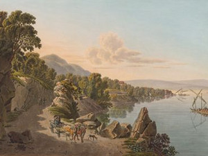
Saint-Gingolph lies on the shores of Lake Geneva opposite Vevey on the border between France and Valais. The village has always been divided in two. At the time this view was created, half of it belonged to the Kingdom of Sardinia-Piedmont and half to the Canton of Vaud. The border between France and Switzerland is formed by the River Morge, which flows through the canton of Vaud and empties into Lake Geneva.


Ort auf moderner Karte
GEOMETRYCOLLECTION (POINT (6.815171 46.390029), LINESTRING (6.815171 46.390029, 6.815021 46.390055))
Camera Settings (3D)
{"landscape":{"viewpoint":{"bounds":[[6.815808334535376,46.298047718020655],[6.960861760899263,46.41318473745508]],"bearing":-76.86313765978286,"pitch":85,"zoom":17.942068706630955,"center":{"lng":6.811837255947012,"lat":46.39052419696708},"cam":{"center":{"lng":6.952330592798944,"lat":46.36055393517222},"zoom":11.627662809189557,"bearing":0},"cameraToCenterDistance":1918.5,"cameraPosition":{"lngLat":{"lng":6.817033874378438,"lat":46.389687663756405},"altitude":417.5344732805845},"cameraTargetElevation":381.7281250000006},"image.scale":25},"portrait":{"viewpoint":{"bounds":[[6.818107543137671,46.32165871007072],[6.925372014333107,46.406787131907066]],"bearing":-76.8631376602412,"pitch":85,"zoom":18.37748079412978,"center":{"lng":6.815171000013606,"lat":46.390029000002585},"cameraToCenterDistance":1918.5,"cameraPosition":{"lngLat":{"lng":6.819013808406339,"lat":46.38941039395465},"altitude":408.2065331980931},"cameraTargetElevation":381.7281250000006}},"square":{"viewpoint":{"bounds":[[6.815808334542254,46.29804772005551],[6.9608617577148095,46.413184736886365]],"bearing":-76.86313765978286,"pitch":85,"zoom":17.942068706630955,"center":{"lng":6.811837255954742,"lat":46.39052419696543},"cam":{"center":{"lng":7.541075450404975,"lat":46.40568010706619},"zoom":8.277196848554091,"bearing":0},"cameraToCenterDistance":1918.5,"cameraPosition":{"lngLat":{"lng":6.817033874386141,"lat":46.38968766375473},"altitude":417.5344732805856},"cameraTargetElevation":381.7281250000006},"image.scale":28}}
Quellen

Johann Gottfried Ebel, Anleitung, auf die nützlichste und genussvollste Art die Schweiz zu bereisen, vol. 2, Zurich 1810, p. 75

Bilder
nb-479857
Ort
GEOMETRYCOLLECTION (POINT (6.846718 46.388232), LINESTRING (6.846718 46.388232, 6.893835 46.397817))
Titel
Vue de l'extrémité du lac de Genève, et de l'entrée du Rhône, près le Boveret
Text

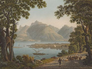
Tourists around 1811 were mainly familiar with the eastern end of Lake Geneva from Jean-Jacques Rousseau's epistolary novel Julie ou la nouvelle Héloïse. This had already been published in 1761 and went through at least 70 editions by 1800 - a veritable bestseller of the 18th century. The tragic love story between the patrician's daughter Julie and her tutor Saint-Preux served Rousseau above all to explain his social, economic and cultural concerns. It is regarded as the forerunner and starting point of Romanticism. Framed romantically by gnarled trees, Gabriel Lory (père?) presents us with a view of the delta of the Rhone estuary and the Dent de Jaman.


Aufnahmestandort
nb-479857
Ort auf moderner Karte
GEOMETRYCOLLECTION (POINT (6.848264 46.387576), LINESTRING (6.848264 46.387576, 6.848398 46.387626))
Camera Settings (3D)
{"landscape":{"viewpoint":{"bounds":[[6.657840467267789,46.29694016360165],[6.848559367842853,46.422375979998634]],"bearing":66.47248191840094,"pitch":85,"zoom":17.731409175326114,"center":{"lng":6.852600910286014,"lat":46.38908651472255},"cam":{"center":{"lng":6.822924912016219,"lat":46.36504038672098},"zoom":11.503958372903602,"bearing":0},"cameraToCenterDistance":1918.5,"cameraPosition":{"lngLat":{"lng":6.8469390444493285,"lat":46.387386178547985},"altitude":409.43680950402586},"cameraTargetElevation":368.00000000000006},"image.scale":29},"portrait":{"viewpoint":{"bounds":[[6.657691103921707,46.29671456275142],[6.848409971163761,46.42215087491584]],"bearing":66.47248191840094,"pitch":85,"zoom":17.731409429010437,"center":{"lng":6.852451512895868,"lat":46.38886127806995},"cameraToCenterDistance":1918.5,"cameraPosition":{"lngLat":{"lng":6.846789648054738,"lat":46.387160935178},"altitude":409.43697320680207},"cameraTargetElevation":368},"image.scale":21},"square":{"viewpoint":{"bounds":[[6.657691101633276,46.29671456166122],[6.8484099711652675,46.42215087533626]],"bearing":66.47248191840094,"pitch":85,"zoom":17.731409429010437,"center":{"lng":6.85245151289746,"lat":46.38886127807035},"cam":{"center":{"lng":7.611285449293234,"lat":46.425239647182906},"zoom":7.882333601717048,"bearing":0},"cameraToCenterDistance":1918.5,"cameraPosition":{"lngLat":{"lng":6.846789648056387,"lat":46.38716093517837},"altitude":409.4369732068018},"cameraTargetElevation":368},"image.scale":28}}
Quellen

Voyage pittoresque de Genève à Milan par le Simplon, Paris 1811, Vue de l'extrémité du lac de Genève, et de l'entrée du Rhône, près le Boveret; Page "Julie oder Die neue Heloise". In: Wikipedia - The free encyclopedia. Edit status: November 8, 2023, 15:20 UTC [06/17/2024]

Bilder
nb-479858
Ort
GEOMETRYCOLLECTION (POINT (7.001644 46.22986), LINESTRING (7.001644 46.22986, 7.005119 46.222556))
Titel
Le Pont de St-Maurice
Text

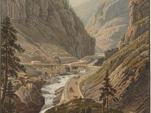
St-Maurice Castle was built at the end of the 15th century and was completely destroyed by fire at the end of the 17th century. Located at the entrance to the Rhône Valley, the castle served as the seat of a governor, as a guard and customs station and, between the 18th and 19th centuries, as an orphanage and old people's home.


Aufnahmestandort
nb-479858
Ort auf moderner Karte
GEOMETRYCOLLECTION (POINT (7.001134 46.228087), LINESTRING (7.001134 46.228087, 7.001322 46.227605))
Camera Settings (3D)
{"landscape":{"viewpoint":{"bounds":[[6.693313015908444,46.22996434560551],[7.228950514687909,46.571827993602994]],"bearing":166.3099950902715,"pitch":84.02304973962177,"zoom":18.381694954897213,"center":{"lng":7.001133999993385,"lat":46.22808700000499},"cam":{"center":{"lng":7.151305113372331,"lat":46.415733587873916},"zoom":10.056391119412657,"bearing":0},"cameraToCenterDistance":1918.5,"cameraPosition":{"lngLat":{"lng":7.000204335559914,"lat":46.230727171102416},"altitude":444.6002337923533},"cameraTargetElevation":412.9642578125779},"image.scale":46},"portrait":{"viewpoint":{"bounds":[[6.696826323822421,46.229964719439295],[7.226332912834721,46.56793404275464]],"bearing":166.30999509123282,"pitch":84.02706079079071,"zoom":18.381705525484485,"center":{"lng":7.001133999995545,"lat":46.22808700000192},"cameraToCenterDistance":1918.5,"cameraPosition":{"lngLat":{"lng":7.000204335562074,"lat":46.230727171099375},"altitude":444.57884866240585},"cameraTargetElevation":412.9642578125779}},"square":{"viewpoint":{"bounds":[[6.977058837425119,46.2080038045452],[7.024125615951107,46.23041510301928]],"bearing":166.30999509123282,"pitch":84.02706079079071,"zoom":17.458248285122288,"center":{"lng":7.001133999996227,"lat":46.22808700000215},"cam":{"center":{"lng":7.012295862934593,"lat":46.219210597213106},"zoom":13.766733445456008,"bearing":0},"cameraToCenterDistance":1011.5176716202244,"cameraPosition":{"lngLat":{"lng":7.000204335562842,"lat":46.23072717109963},"altitude":445.4458408497511},"cameraTargetElevation":413.8312499999233},"image.scale":106}}
Bilder
nb-479859
Ort
GEOMETRYCOLLECTION (POINT (7.02855 46.144656), LINESTRING (7.02855 46.144656, 7.034815 46.136389))
Titel
Vue de la Cascade de Pissevache
Text

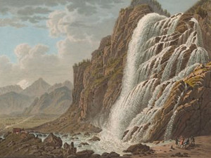
The Pissevache is located on the road between Saint-Maurice and Martigny and impressed many travelers in the 19th century. It is formed by the Salenche torrent and carried plenty of water at the time. Robert Glutz von Blotzheim recommends visiting the waterfall in the morning, as the sun's rays draw a rainbow. Since 1953, some of the water above the Pissevache has been diverted to produce electricity. It now looks much less imposing due to this.


Ort auf moderner Karte
GEOMETRYCOLLECTION (POINT (7.031239 46.145801), LINESTRING (7.031239 46.145801, 7.03132 46.145663))
Camera Settings (3D)
{"landscape":{"viewpoint":{"bounds":[[7.005040009506445,46.146649727261234],[7.048243808366578,46.170991676656485]],"bearing":160.24999169946727,"pitch":84.99589172222522,"zoom":18.48061221458448,"center":{"lng":7.031557112932205,"lat":46.145270916617875},"cam":{"center":{"lng":7.040123193062158,"lat":46.15985959041234},"zoom":13.874676364216606,"bearing":0},"cameraToCenterDistance":1436.3405169117464,"cameraPosition":{"lngLat":{"lng":7.030627670082708,"lat":46.14706443035669},"altitude":469.9187026771329},"cameraTargetElevation":451.3647338867196},"image.scale":34,"camera.fov":48},"portrait":{"viewpoint":{"bounds":[[7.017870156605937,46.1467807189118],[7.040956072671236,46.15800179126617]],"bearing":160.2499917008124,"pitch":85,"zoom":18.707240917464926,"center":{"lng":7.031238999990364,"lat":46.14580100000268},"cameraToCenterDistance":1153.6885394960755,"cameraPosition":{"lngLat":{"lng":7.030600979618839,"lat":46.14703216029275},"altitude":464.0905599242392},"cameraTargetElevation":451.3647338867196},"image.scale":37,"camera.fov":58},"square":{"viewpoint":{"bounds":[[7.00652914415295,46.147030824242535],[7.046510361783277,46.169932621447714]],"bearing":160.2499917008124,"pitch":85,"zoom":18.67411107614787,"center":{"lng":7.031238999992752,"lat":46.145801000001626},"cam":{"center":{"lng":7.206435232304614,"lat":46.17232798686953},"zoom":10.136386875990738,"bearing":0},"cameraToCenterDistance":1470.7493089575862,"cameraPosition":{"lngLat":{"lng":7.030406742533586,"lat":46.14740696572332},"altitude":467.96477381486073},"cameraTargetElevation":451.3647338867196},"camera.fov":47}}
Quellen

Robert Glutz von Blotzheim,  Handbuch für Reisende in der Schweiz, Zurich 1819, p. 287; Voyage pittoresque de Genève à Milan par le Simplon, Paris 1811, Vue de la Cascade de Pissevache; https://www.alpiq.com/de/energieerzeugung/wasserkraftwerke/speicherkraftwerke/salanfe [03.11.2023]

Bilder
nb-479860
Ort
GEOMETRYCOLLECTION (POINT (7.344974 46.232655), LINESTRING (7.344974 46.232655, 7.387193 46.238919))
Titel
Vue de Sion prise du côté du couchant
Text

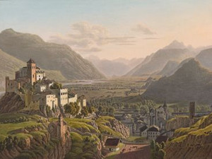
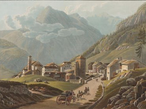
The first view of Sion was drawn from Mont d'Orge. The accompanying text is not very flattering for the people of Valais: the author literally writes that "the appearance of the villages you pass through proves that the accusations of laziness and poor cleanliness made against the Valaisans are all too well-founded". Sion, on the other hand, is one of the most remarkable places in Switzerland due to its white houses, the two castles and the glaciers that surround it.


Aufnahmestandort
nb-479860
Ort auf moderner Karte
GEOMETRYCOLLECTION (POINT (7.342359 46.229246), LINESTRING (7.342359 46.229246, 7.342499 46.229268))
Camera Settings (3D)
{"landscape":{"image.scale":22,"viewpoint":{"bounds":[[6.628480966336241,45.866439283486784],[7.3437094138145085,46.47186767466647]],"bearing":70.30594624045385,"pitch":82.5018057121629,"zoom":16.912823690636326,"center":{"lng":7.349032759666443,"lat":46.23090811186378},"cam":{"center":{"lng":7.321467077005082,"lat":46.1957862276067},"zoom":9.237944434845371,"bearing":0},"cameraToCenterDistance":1470.7493089575862,"cameraPosition":{"lngLat":{"lng":7.341209329850102,"lat":46.228970975343316},"altitude":580.5643677607951},"cameraTargetElevation":496.4374999999993}},"portrait":{"image.scale":19,"viewpoint":{"bounds":[[6.630356089606835,45.867395704957374],[7.343708974097922,46.47123114306319]],"bearing":70.30594624028733,"pitch":82.50361116183473,"zoom":16.91282967347212,"center":{"lng":7.349032759668262,"lat":46.230908111863215},"cameraToCenterDistance":1470.7493089575862,"cameraPosition":{"lngLat":{"lng":7.341209329851949,"lat":46.228970975342776},"altitude":580.5438782494416},"cameraTargetElevation":496.4374999999993}},"square":{"viewpoint":{"bounds":[[6.580912469484247,45.842214127641284],[7.343538875839499,46.48781132065298]],"bearing":70.30594624040033,"pitch":82.50182352225615,"zoom":16.8202139832431,"center":{"lng":7.349215149879456,"lat":46.230921099858676},"cam":{"center":{"lng":10.394044501260595,"lat":46.429412780329784},"zoom":5.882804705185486,"bearing":0},"cameraToCenterDistance":1470.7493089575862,"cameraPosition":{"lngLat":{"lng":7.340873047634659,"lat":46.22885553445113},"altitude":586.1415168664631},"cameraTargetElevation":496.4374999999993},"image.scale":30}}
Quellen

Voyage pittoresque de Genève à Milan par le Simplon, Paris 1811, Vue de Sion prise du côté du couchant

Bilder
nb-479861
Ort
GEOMETRYCOLLECTION (POINT (7.367 46.2359), LINESTRING (7.367 46.2359, 7.339569 46.225729))
Titel
Vue de Sion prise du côté du levant
Text

Click on "Open image details" for more information.

Aufnahmestandort
nb-479861
Ort auf moderner Karte
GEOMETRYCOLLECTION (POINT (7.367658 46.235539), LINESTRING (7.367658 46.235539, 7.367529 46.235506))
Camera Settings (3D)
{"landscape":{"image.scale":45,"viewpoint":{"bounds":[[7.36825763872838,46.19705110347019],[7.54062504842301,46.325953390296576]],"bearing":-117.67983311190017,"pitch":83.49731231324282,"zoom":17.636231984581517,"center":{"lng":7.365244030952454,"lat":46.234644816779394},"cam":{"center":{"lng":7.525964836501032,"lat":46.267034189905246},"zoom":11.467217093768463,"bearing":0},"cameraToCenterDistance":1470.7493089575862,"cameraPosition":{"lngLat":{"lng":7.369710351874716,"lat":46.236265368720865},"altitude":623.966294638422},"cameraTargetElevation":579.7500976562512}},"portrait":{"viewpoint":{"bounds":[[7.319261112754361,46.206946871100314],[7.369367407674133,46.252167452888386]],"bearing":-117.67983311313422,"pitch":83.5,"zoom":17.26832907786277,"center":{"lng":7.365244030951203,"lat":46.234644816779024},"cameraToCenterDistance":1139.6894313803214,"cameraPosition":{"lngLat":{"lng":7.369710351873465,"lat":46.236265368720524},"altitude":624.1929786317659},"cameraTargetElevation":579.9952148437513},"image.scale":45},"square":{"viewpoint":{"bounds":[[7.368279709709412,46.19684819309097],[7.541602673088988,46.32646471000558]],"bearing":-117.67983311211106,"pitch":83.4973123131975,"zoom":17.628256191526663,"center":{"lng":7.365249395370483,"lat":46.23465038268432},"cam":{"center":{"lng":8.234894526607263,"lat":46.32157678571639},"zoom":8.020318382886893,"bearing":0},"cameraToCenterDistance":1470.7493089575862,"cameraPosition":{"lngLat":{"lng":7.369740476272881,"lat":46.23627991819433},"altitude":624.2114118259224},"cameraTargetElevation":579.7500976562512},"image.scale":45}}
Bilder
nb-479862
Ort
GEOMETRYCOLLECTION (POINT (7.9819 46.3215), LINESTRING (7.9819 46.3215, 8.023507 46.288608))
Titel
Vue de Brieg
Text

At first glance, Gabriel Lory fils presents us with a classic view of the town at the start of the mountain route over the Simplon. In contrast to earlier depictions of Brig, however, the Alpine crossing over the Simplon comes into focus here. The evenly ascending new pass road was begun in 1801 on the orders of Emperor Napoleon (1769 - 1821) and completed in 1805. It runs through the entire picture and can be seen in the wooded slopes in the middle ground.

In the center of the view is the town of Brig with the Jesuit church and the towers of the Stockalper Palace, which bear witness to an earlier heyday of pass traffic. In the 17th century, Kaspar Stockalper (1609 - 1691) had already had the pass road widened once, after it had previously hardly been used. Control of the pass increased his wealth and earned him the unofficial title of "le roi du Simplon" at the French royal court.

Stockalper's removal from power in 1679 led to a renewed collapse of the infrastructure. The Simplon only regained international importance with the expansion ordered by Napoleon.


Aufnahmestandort
nb-479862
Ort auf moderner Karte
GEOMETRYCOLLECTION (POINT (7.98131 46.3207), LINESTRING (7.98131 46.3207, 7.981385 46.320641))
Camera Settings (3D)
{"landscape":{"image.scale":15,"viewpoint":{"bounds":[[7.975712205603372,46.30062332518318],[8.00527869000976,46.32103089894957]],"bearing":137.6504432885621,"pitch":85,"zoom":18.15206410738563,"center":{"lng":7.982712686061859,"lat":46.31965744223922},"cam":{"center":{"lng":7.997644619127158,"lat":46.310828063216064},"zoom":14.477842351137655,"bearing":0},"cameraToCenterDistance":1139.6894313803214,"cameraPosition":{"lngLat":{"lng":7.980866467539528,"lat":46.3210562665835},"altitude":689.999736114059},"cameraTargetElevation":671.5863769529077}},"portrait":{"viewpoint":{"bounds":[[7.94849035820215,46.32058675900393],[7.9835098476361,46.34894492198262]],"bearing":137.65044328759905,"pitch":84.99523409844713,"zoom":18.519964222316197,"center":{"lng":7.98271268606149,"lat":46.31965744224033},"cameraToCenterDistance":1470.7493089575862,"cameraPosition":{"lngLat":{"lng":7.98086646753913,"lat":46.32105626658452},"altitude":690.0173769182327},"cameraTargetElevation":671.5863769529077},"image.scale":13},"square":{"image.scale":15,"viewpoint":{"bounds":[[7.975712205597318,46.300623325201826],[8.005278689976791,46.32103089895364]],"bearing":137.6504432885621,"pitch":85,"zoom":18.15206410738563,"center":{"lng":7.982712686057994,"lat":46.31965744224331},"cam":{"center":{"lng":8.03747780652705,"lat":46.31082806322743},"zoom":11.761571135846012,"bearing":0},"cameraToCenterDistance":1139.6894313803214,"cameraPosition":{"lngLat":{"lng":7.980866467535606,"lat":46.32105626658759},"altitude":689.9997361140577},"cameraTargetElevation":671.5863769529077}}}
Bilder
nb-479863
Ort
GEOMETRYCOLLECTION (POINT (8.048018 46.297922), LINESTRING (8.048018 46.297922, 8.073067 46.299891))
Titel
Vue de la Galerie et du Pont de Ganther
Text

Eight bridges and seven tunnels as well as numerous dams and retaining walls overcome the natural obstacles. 
The French writer and archaeologist Désiré Raoul-Rochette (1789 - 1854) wrote in 1820: "The Simplon crossing has nothing to compare with it in the work of man. Over a space of fourteen lieues, from Brig to Domo-d'Ossola, it is a kind of battlefield on which nature and art constantly struggle with each other [...]."

The engineer in charge, Nicolas Céard (1745 - 1821), had planned a uniform gradient of 3 - 8 % along the entire route and a road width of 5 - 8 meters. For this reason, the road could not follow the medieval path like Stockalper's road, but had to run along the valley slopes, over streams, through rocky outcrops and the terrifying Gondo Gorge.


Aufnahmestandort
nb-479863
Ort auf moderner Karte
GEOMETRYCOLLECTION (POINT (8.049374 46.297696), LINESTRING (8.049374 46.297696, 8.049481 46.297689))
Camera Settings (3D)
{"landscape":{"camera.fov":60,"image.scale":79,"viewpoint":{"bounds":[[7.9559012455444815,46.25167519235788],[8.046533055265428,46.382144397021676]],"bearing":93.91489765627419,"pitch":81.49999999999999,"zoom":17.706233139625397,"center":{"lng":8.049373999998352,"lat":46.297696000001395},"cam":{"center":{"lng":8.073683341782555,"lat":46.32250952058425},"zoom":11.448326215289057,"bearing":0},"cameraToCenterDistance":1107.646491440297,"cameraPosition":{"lngLat":{"lng":8.045780521057651,"lat":46.29786590698188},"altitude":1470.1894496505283},"cameraTargetElevation":1428.8336425792158}},"portrait":{"viewpoint":{"bounds":[[7.955901246422087,46.25167519281575],[8.046533055265712,46.38214439620634]],"bearing":93.91489765627419,"pitch":81.49999999999999,"zoom":17.706233139625397,"center":{"lng":8.04937399999858,"lat":46.29769600000142},"cameraToCenterDistance":1107.646491440297,"cameraPosition":{"lngLat":{"lng":8.04578052105785,"lat":46.29786590698191},"altitude":1470.1894496505283},"cameraTargetElevation":1428.8336425792158},"image.scale":81},"square":{"image.scale":92,"viewpoint":{"bounds":[[7.955901246456307,46.25167519283684],[8.046533055266934,46.38214439619722]],"bearing":93.91489765627419,"pitch":81.49999999999999,"zoom":17.706233139625397,"center":{"lng":8.04937400000017,"lat":46.29769600000114},"cam":{"center":{"lng":8.409060290509387,"lat":46.34823799687982},"zoom":8.955691808025234,"bearing":0},"cameraToCenterDistance":1107.646491440297,"cameraPosition":{"lngLat":{"lng":8.045780521059442,"lat":46.29786590698163},"altitude":1470.1894496505286},"cameraTargetElevation":1428.8336425792158}}}
Quellen

Désiré Raoul-Rochette, Lettres sur la Suisse, Paris 1822, p. 375; Federal Inventory of Historic Transport Routes in Switzerland (IVS), VS 1.4.3 (PDF) [03.11.2023]

Bilder
nb-642409
Ort
GEOMETRYCOLLECTION (POINT (8.03954 46.264465), LINESTRING (8.03954 46.264465, 8.037539 46.243917))
Titel
Vue prise de la sortie de la galerie de Schalbet du côté de l'Italie
Text

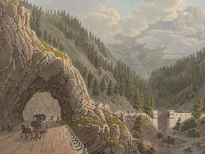
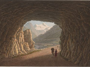
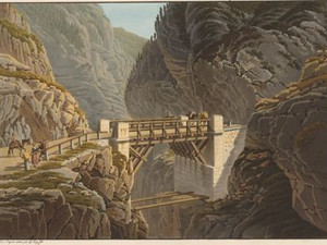
On the western slope of the Mäderhorn towards the Taferna Valley, the road passed through the Schallbett Tunnel, which was around 31 m long. 
The national road built from 1960 onwards largely follows the course of the road from 1805, which underlines the extraordinary achievement of Napoleon's engineers and road builders. However, almost nothing of the old road remains. The Schallbett Gallery also fell victim to the modern highway.


Ort auf moderner Karte
GEOMETRYCOLLECTION (POINT (8.040513 46.263316), LINESTRING (8.040513 46.263316, 8.040506 46.263198))
Camera Settings (3D)
{"landscape":{"viewpoint":{"bounds":[[7.676901060657173,46.268969839944646],[8.613790025884583,46.772388889186146]],"bearing":179.81473919713093,"pitch":84.9805527988679,"zoom":15.517341297732695,"center":{"lng":8.039588928227403,"lat":46.2533541998196},"cam":{"center":{"lng":8.426007968879048,"lat":46.542715936175796},"zoom":9.494870260327424,"bearing":0},"cameraToCenterDistance":1918.5,"cameraPosition":{"lngLat":{"lng":8.039496287785767,"lat":46.2731618778958},"altitude":2085.7844883060134},"cameraTargetElevation":1892.3000005836025},"image.scale":324},"portrait":{"viewpoint":{"bounds":[[7.847423892178483,46.2653662204705],[8.392366839434885,46.56223496046826]],"bearing":-177.78526080291522,"pitch":84.02705419280755,"zoom":18.38077798020887,"center":{"lng":8.040512999998782,"lat":46.263315999998696},"cameraToCenterDistance":1918.5,"cameraPosition":{"lngLat":{"lng":8.040664899547522,"lat":46.266031340596584},"altitude":1923.9146492622717},"cameraTargetElevation":1892.3000005836025},"image.scale":73},"square":{"viewpoint":{"bounds":[[7.847423900226261,46.265366220471236],[8.392366824413102,46.562234948025946]],"bearing":-177.78526080291522,"pitch":84.02705419280755,"zoom":18.38077798020887,"center":{"lng":8.040512999998782,"lat":46.263315999999605},"cam":{"center":{"lng":10.572138521160525,"lat":46.60153250002094},"zoom":6.3676760572992235,"bearing":0},"cameraToCenterDistance":1918.5,"cameraPosition":{"lngLat":{"lng":8.040664899547522,"lat":46.26603134059749},"altitude":1923.9146492622713},"cameraTargetElevation":1892.3000005836025},"image.scale":78}}
Bilder
nb-479865
Ort
GEOMETRYCOLLECTION (POINT (8.040487 46.262141), LINESTRING (8.040487 46.262141, 8.027238 46.272352))
Titel
Vue de la galerie de Schalbet prise du côté de l'Italie
Text

Click on "Open image details" for more information.

Ort auf moderner Karte
GEOMETRYCOLLECTION (POINT (8.040631 46.262316), LINESTRING (8.040631 46.262316, 8.040581 46.262397))
Camera Settings (3D)
{"landscape":{"image.scale":55,"viewpoint":{"bounds":[[7.896894933611293,46.1877346273275],[8.13094728751065,46.2610370004343]],"bearing":0,"pitch":80.51770517173509,"zoom":18.31538494184277,"center":{"lng":8.040948808193207,"lat":46.26231986472686},"cam":{"center":{"lng":8.064149931666122,"lat":46.228259034384365},"zoom":11.977118872895705,"bearing":0},"cameraToCenterDistance":1107.646491440297,"cameraPosition":{"lngLat":{"lng":8.04094880819332,"lat":46.260691739302246},"altitude":1936.4872327617577},"cameraTargetElevation":1906.2495605468748}},"portrait":{"image.scale":36,"viewpoint":{"bounds":[[7.896894933560276,46.18773462736226],[8.13094728746509,46.26103700043504]],"bearing":0,"pitch":80.51770517173509,"zoom":18.31538494184277,"center":{"lng":8.04094880819332,"lat":46.26231986472774},"cameraToCenterDistance":1107.646491440297,"cameraPosition":{"lngLat":{"lng":8.040948808193377,"lat":46.26069173930313},"altitude":1936.4872327617572},"cameraTargetElevation":1906.2495605468748}},"square":{"camera.fov":51,"image.scale":32,"viewpoint":{"bounds":[[7.749910491210244,46.260839743699734],[8.50679220372291,46.54476570288122]],"bearing":0,"pitch":80.51770517173509,"zoom":18.31538494184277,"center":{"lng":8.040948808192525,"lat":46.2623198647274},"cam":{"center":{"lng":11.534319053773572,"lat":46.6633292893635},"zoom":5.893713341608038,"bearing":0},"cameraToCenterDistance":1340.7396316168877,"cameraPosition":{"lngLat":{"lng":8.040948808192496,"lat":46.26034911041219},"altitude":1942.8504488443837},"cameraTargetElevation":1906.2495605468748}}}
Bilder
nb-479866
Ort
GEOMETRYCOLLECTION (POINT (8.043746 46.251004), LINESTRING (8.043746 46.251004, 8.053622 46.251081))
Titel
Vue de la Galerie des Glaciers
Text

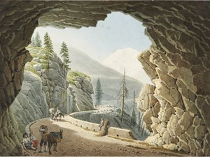
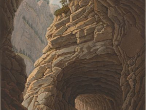
The glacier gallery with the section of road shown in the foreground is the only part of the Napoleon road on the north side of the Simplon still preserved in its 19th century condition. 
Nicolas Céard originally wanted to tunnel the entire course of the road in this exposed and difficult terrain below the Chaltwasser glacier. However, Napoleon did not agree to this gigantic project.


Ort auf moderner Karte
GEOMETRYCOLLECTION (POINT (8.045506 46.250646), LINESTRING (8.045506 46.250646, 8.045619 46.250635))
Camera Settings (3D)
{"landscape":{"camera.fov":60,"image.scale":218,"viewpoint":{"bounds":[[7.96750523301705,46.24080598701161],[8.041685846887674,46.31873046375725]],"bearing":117.03438386467337,"pitch":84.99099173952199,"zoom":16.234983476942126,"center":{"lng":8.048923015613099,"lat":46.24986360147099},"cam":{"center":{"lng":8.047847574190484,"lat":46.28310343345282},"zoom":12.192866300087816,"bearing":0},"cameraToCenterDistance":1107.646491440297,"cameraPosition":{"lngLat":{"lng":8.039963120052022,"lat":46.25302516414348},"altitude":2076.1972440649524},"cameraTargetElevation":2008.405078123432}},"portrait":{"image.scale":67,"viewpoint":{"bounds":[[8.01556197400248,46.25098847075736],[8.048803552853173,46.27700043959558]],"bearing":133.0554731167939,"pitch":84.98704945556712,"zoom":17.615390888927458,"center":{"lng":8.047050833702087,"lat":46.24977828118608},"cameraToCenterDistance":1107.646491440297,"cameraPosition":{"lngLat":{"lng":8.044227623077006,"lat":46.25160233236363},"altitude":2034.465230373195},"cameraTargetElevation":2008.405078123432},"camera.fov":60},"square":{"image.scale":75,"viewpoint":{"bounds":[[8.01556197381089,46.250988470753896],[8.048803552924596,46.27700043998158]],"bearing":133.0554731167939,"pitch":84.98704945556705,"zoom":17.615390888927458,"center":{"lng":8.047050833706834,"lat":46.24977828118256},"cam":{"center":{"lng":8.181769869379536,"lat":46.27548535373876},"zoom":10.402720368333354,"bearing":0},"cameraToCenterDistance":1107.646491440297,"cameraPosition":{"lngLat":{"lng":8.044227623081838,"lat":46.251602332360136},"altitude":2034.465230373197},"cameraTargetElevation":2008.405078123432}}}
Bilder
nb-479867
Ort
GEOMETRYCOLLECTION (POINT (8.027921 46.250204), LINESTRING (8.027921 46.250204, 8.017666 46.240484))
Titel
Vue de l'emplacement de l'Hospice du Simplon et du Mont-Rosa
Text

A little below the top of the pass in the direction of Italy, Napoleon had a generously dimensioned hospice built in the style of the Great St. Bernard. Construction began in 1813, but was not completed until 1831 by the canton of Valais, as the fall of Napoleon interrupted building work. However, the building site, which had already been prepared in 1808, can be seen.


Aufnahmestandort
nb-479867
Ort auf moderner Karte
GEOMETRYCOLLECTION (POINT (8.02827 46.249185), LINESTRING (8.02827 46.249185, 8.028243 46.249092))
Camera Settings (3D)
{"landscape":{"image.scale":125,"viewpoint":{"bounds":[[7.965757834034548,46.25048122748683],[8.212066489728755,46.34662442064737]],"bearing":-164.65535069852834,"pitch":84.98052109654881,"zoom":15.22774619442576,"center":{"lng":8.024944067001343,"lat":46.239212379569096},"cam":{"center":{"lng":8.142294818395754,"lat":46.302671783404065},"zoom":11.889263186555961,"bearing":0},"cameraToCenterDistance":1107.646491440297,"cameraPosition":{"lngLat":{"lng":8.0302944748438,"lat":46.252696555114},"altitude":2130.7952888349378},"cameraTargetElevation":1994.2184570312509}},"portrait":{"image.scale":84,"viewpoint":{"bounds":[[7.989929080445677,46.24964987262152],[8.139046130896219,46.307880649574884]],"bearing":-164.65535069852834,"pitch":85,"zoom":15.94142034720205,"center":{"lng":8.025738000862702,"lat":46.242774146813076},"cameraToCenterDistance":1107.646491440297,"cameraPosition":{"lngLat":{"lng":8.029000590884777,"lat":46.25099643408322},"altitude":2106.9294061100627},"cameraTargetElevation":2023.9773433234507}},"square":{"image.scale":73,"viewpoint":{"bounds":[[7.9899290804430905,46.24964987262092],[8.139046130870128,46.30788064956721]],"bearing":-164.65535069852834,"pitch":85,"zoom":15.94142034720205,"center":{"lng":8.02573800086168,"lat":46.242774146812565},"cam":{"center":{"lng":8.735514332578362,"lat":46.33027990605606},"zoom":8.237335962702415,"bearing":0},"cameraToCenterDistance":1107.646491440297,"cameraPosition":{"lngLat":{"lng":8.029000590883697,"lat":46.25099643408271},"altitude":2106.9294061100636},"cameraTargetElevation":2023.9773433234507}}}
Bilder
nb-479868
Ort
GEOMETRYCOLLECTION (POINT (8.052642 46.197322), LINESTRING (8.052642 46.197322, 8.063197 46.189806))
Titel
Vue du village de Simplon
Text

The village of Simplon has always been directly dependent on the pass road and the traffic it brought. After the Simplon railroad tunnel was opened in 1906, the community felt so cut off from the rest of Switzerland that it stayed away from a federal vote in 1907 in protest.


Aufnahmestandort
nb-479868
Ort auf moderner Karte
GEOMETRYCOLLECTION (POINT (8.053585 46.19765), LINESTRING (8.053585 46.19765, 8.05366 46.197549))
Camera Settings (3D)
{"landscape":{"viewpoint":{"bounds":[[8.005070626762716,46.12489677282721],[8.137779625487667,46.19911109111419]],"bearing":150.35752096987312,"pitch":74.5,"zoom":17.93510065950639,"center":{"lng":8.053539097283078,"lat":46.19751324118482},"cam":{"center":{"lng":8.112529574193559,"lat":46.16517966851393},"zoom":12.266339765685986,"bearing":0},"cameraToCenterDistance":1107.646491440297,"cameraPosition":{"lngLat":{"lng":8.052058001636965,"lat":46.19931473766138},"altitude":1558.4045906005572},"cameraTargetElevation":1494.485522605671},"image.scale":63,"camera.fov":60},"portrait":{"viewpoint":{"bounds":[[8.005070627107159,46.12489677338155],[8.13777962498989,46.199111091113394]],"bearing":150.35752096987312,"pitch":74.5,"zoom":17.93510065950639,"center":{"lng":8.05353909728342,"lat":46.197513241183884},"cameraToCenterDistance":1107.646491440297,"cameraPosition":{"lngLat":{"lng":8.052058001637164,"lat":46.19931473766047},"altitude":1558.404590600558},"cameraTargetElevation":1494.485522605671},"image.scale":72},"square":{"viewpoint":{"bounds":[[8.005070626714712,46.12489677268346],[8.137779625644953,46.19911109111396]],"bearing":150.35752096987312,"pitch":74.5,"zoom":17.93510065950639,"center":{"lng":8.053539097281941,"lat":46.19751324118451},"cam":{"center":{"lng":8.668615621365944,"lat":46.207955803615846},"zoom":8.405514988769273,"bearing":0},"cameraToCenterDistance":1107.646491440297,"cameraPosition":{"lngLat":{"lng":8.0520580016358,"lat":46.19931473766107},"altitude":1558.4045906005574},"cameraTargetElevation":1494.485522605671},"image.scale":84}}
Bilder
nb-479869
Ort
GEOMETRYCOLLECTION (POINT (8.072983 46.184507), LINESTRING (8.072983 46.184507, 8.086539 46.188607))
Titel
Vue de la Galerie d'Algaby [Gabi], prise du côté du Valais
Text

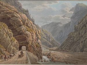
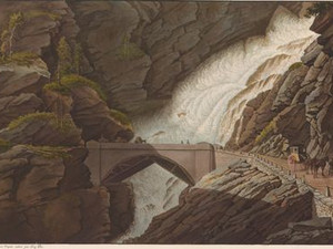
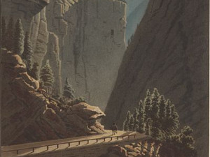
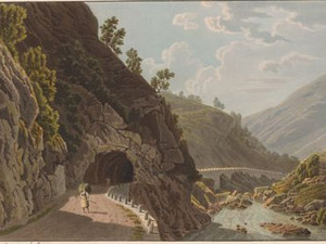
The most challenging section of the Simplon road led through the Gondo Gorge. The gorge was terrifying for the engineers and construction workers as well as for the travelers. However, the latter also seem to have derived a certain thrill from their trip. Désiré Raoul-Rochette (1789 - 1845) wrote about the route: "It is beyond the village of Simplon that the magnificent horrors of this astonishing road unfold in all their extent[...]."
At the upper entrance to the gorge, shortly after the village of Gabi, the road led through the tunnel of the same name, about 65 m long. This was widened during the construction of the N9 in the 1960s to such an extent that nothing remains of it today.


Ort auf moderner Karte
GEOMETRYCOLLECTION (POINT (8.075693 46.184966), LINESTRING (8.075693 46.184966, 8.07619 46.185012))
Camera Settings (3D)
{"landscape":{"camera.fov":60,"image.scale":71,"viewpoint":{"bounds":[[7.968553270568606,46.12566987928179],[8.074202048678472,46.23205242350954]],"bearing":69.9046060849198,"pitch":85,"zoom":15.860054028344788,"center":{"lng":8.083990216255188,"lat":46.18708025892559},"cam":{"center":{"lng":8.080316922270356,"lat":46.18342114581742},"zoom":11.746405275649568,"bearing":0},"cameraToCenterDistance":1107.646491440297,"cameraPosition":{"lngLat":{"lng":8.071739882982826,"lat":46.18397734718039},"altitude":1301.1276043836358},"cameraTargetElevation":1213.2736450090526}},"portrait":{"viewpoint":{"bounds":[[8.074179907886645,46.13142983468231],[8.189951872677966,46.24952549437049]],"bearing":69.90460608612216,"pitch":77.02731789695501,"zoom":18.58260027415897,"center":{"lng":8.07570084930012,"lat":46.18493920098595},"cameraToCenterDistance":1107.646491440297,"cameraPosition":{"lngLat":{"lng":8.073885303207675,"lat":46.184479330780334},"altitude":1247.5586577848692},"cameraTargetElevation":1213.2736450090526},"image.scale":44},"square":{"viewpoint":{"bounds":[[8.07417990788528,46.131429835046845],[8.18995187177606,46.24952549386728]],"bearing":69.90460608612216,"pitch":77.02731789695501,"zoom":18.58260027415897,"center":{"lng":8.075700849299324,"lat":46.18493920098561},"cam":{"center":{"lng":8.653039727339205,"lat":46.23056708219485},"zoom":8.602495268225548,"bearing":0},"cameraToCenterDistance":1107.646491440297,"cameraPosition":{"lngLat":{"lng":8.073885303206822,"lat":46.18447933077999},"altitude":1247.5586577848694},"cameraTargetElevation":1213.2736450090526}}}
Quellen

Désiré Raoul-Rochette, Lettres sur la Suisse, Paris 1822, p. 384; Voyage pittoresque de Genève à Milan par le Simplon, Paris 1811, Vue de la Galerie d'Algaby, prise du côté du Valais; Federal Inventory of Historic Transport Routes in Switzerland (IVS), VS 1.4.7 (PDF) [03.11.2023]

Bilder
nb-479870
Ort
GEOMETRYCOLLECTION (POINT (8.075556 46.185438), LINESTRING (8.075556 46.185438, 8.067233 46.182497))
Titel
Vue prise de l'Intérieur de la Galerie d'Algaby
Text

Click on "Open image details" for more information.

Ort auf moderner Karte
GEOMETRYCOLLECTION (POINT (8.076915 46.185216), LINESTRING (8.076915 46.185216, 8.076775 46.18519))
Camera Settings (3D)
{"landscape":{"camera.fov":60,"image.scale":46,"viewpoint":{"bounds":[[8.077981101845154,46.18138276961949],[8.097129275338716,46.19614747686279]],"bearing":-124.95702891683742,"pitch":85,"zoom":18.512407435157325,"center":{"lng":8.076730817553539,"lat":46.185039477888296},"cam":{"center":{"lng":8.095736769145333,"lat":46.18939494682104},"zoom":14.595182806233428,"bearing":0},"cameraToCenterDistance":1107.646491440297,"cameraPosition":{"lngLat":{"lng":8.078431332359997,"lat":46.185862524974425},"altitude":1245.9972608077596},"cameraTargetElevation":1232.022656254173}},"portrait":{"viewpoint":{"bounds":[[8.077981101843989,46.18138276963478],[8.097129275272692,46.1961474768236]],"bearing":-124.95702891683742,"pitch":85,"zoom":18.512407435157325,"center":{"lng":8.07673081755263,"lat":46.185039477888694},"cameraToCenterDistance":1107.646491440297,"cameraPosition":{"lngLat":{"lng":8.07843133235906,"lat":46.18586252497482},"altitude":1245.9972608077596},"cameraTargetElevation":1232.022656254173},"image.scale":44},"square":{"viewpoint":{"bounds":[[8.077981101841715,46.181382769627305],[8.097129275288438,46.19614747682664]],"bearing":-124.95702891683742,"pitch":85,"zoom":18.512407435157325,"center":{"lng":8.076730817550242,"lat":46.185039477886676},"cam":{"center":{"lng":8.173721969075302,"lat":46.19539321294178},"zoom":11.19850250675011,"bearing":0},"cameraToCenterDistance":1107.646491440297,"cameraPosition":{"lngLat":{"lng":8.078431332356786,"lat":46.18586252497275},"altitude":1245.99726080776},"cameraTargetElevation":1232.022656254173},"image.scale":66,"camera.fov":60}}
Bilder
nb-479871
Ort
GEOMETRYCOLLECTION (POINT (8.098581 46.18887), LINESTRING (8.098581 46.18887, 8.083206 46.182795))
Titel
Ponte Alto
Text

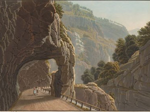
The first of two bridges over the Doveria is the Ponte Alto. Its original wooden roadway can still be seen here, which was replaced by a stone arch between 1850 and 1880.


Ort auf moderner Karte
GEOMETRYCOLLECTION (POINT (8.09902 46.189314), LINESTRING (8.09902 46.189314, 8.09885 46.189149))
Camera Settings (3D)
{"landscape":{"viewpoint":{"bounds":[[8.09954431142603,46.19001556682977],[8.120514681341945,46.2013024523599]],"bearing":-142.13254432117787,"pitch":84.99206843053754,"zoom":18.486913158770488,"center":{"lng":8.099032044410706,"lat":46.18932800148909},"cam":{"center":{"lng":8.116284693003308,"lat":46.19614038989721},"zoom":14.982507149157001,"bearing":0},"cameraToCenterDistance":1107.646491440297,"cameraPosition":{"lngLat":{"lng":8.100328358614433,"lat":46.190482114179844},"altitude":1079.8570571972396},"cameraTargetElevation":1065.611914062501}},"portrait":{"viewpoint":{"bounds":[[8.099544311429383,46.190015566826816],[8.120514681338193,46.20130245234972]],"bearing":-142.13254432117787,"pitch":84.99206843053754,"zoom":18.486913158770488,"center":{"lng":8.09903204441116,"lat":46.189328001488605},"cameraToCenterDistance":1107.646491440297,"cameraPosition":{"lngLat":{"lng":8.100328358614917,"lat":46.19048211417933},"altitude":1079.8570571972398},"cameraTargetElevation":1065.611914062501}},"square":{"viewpoint":{"bounds":[[8.099544311429867,46.19001556682443],[8.120514681356838,46.201302452360494]],"bearing":-142.13254432117787,"pitch":84.99206843053754,"zoom":18.486913158770488,"center":{"lng":8.09903204441116,"lat":46.189328001488576},"cam":{"center":{"lng":8.204396161064778,"lat":46.20291664260145},"zoom":11.067356974640413,"bearing":0},"cameraToCenterDistance":1107.646491440297,"cameraPosition":{"lngLat":{"lng":8.100328358614888,"lat":46.19048211417933},"altitude":1079.8570571972398},"cameraTargetElevation":1065.611914062501}}}
Bilder
nb-479872
Ort
GEOMETRYCOLLECTION (POINT (8.113869 46.195197), LINESTRING (8.113869 46.195197, 8.104567 46.192737))
Titel
Vue de la nouvelle route près la grande galerie
Text

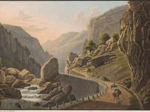
The second crossing of the Doveria takes place via the Casermetta bridge. This view of the route, which stretches evenly along the bottom of the wild gorge, illustrates particularly well what Raoul-Rochette wrote about the Simplon road: 
"What is most astonishing about it is that it runs evenly and steadfastly, never yielding to the difficulties it encounters, and concealing under this boldness itself an extreme audacity. Elsewhere I have seen paths hewn out of the rock or suspended over precipices [...]. But here it is a safe and comfortable path of constant width and gradient, continuing its majestic course over all obstacles [...]."


Ort auf moderner Karte
GEOMETRYCOLLECTION (POINT (8.114009 46.195514), LINESTRING (8.114009 46.195514, 8.113521 46.195269))
Camera Settings (3D)
{"landscape":{"camera.fov":60,"viewpoint":{"bounds":[[8.114928149727234,46.194970746775994],[8.133871022190306,46.20649749370935]],"bearing":-137.17627616605392,"pitch":85,"zoom":18.599366035539155,"center":{"lng":8.114048391575807,"lat":46.19552111973658},"cam":{"center":{"lng":8.130788303914613,"lat":46.20122573681641},"zoom":14.95203593237574,"bearing":0},"cameraToCenterDistance":1107.646491440297,"cameraPosition":{"lngLat":{"lng":8.115376265739172,"lat":46.19651288271848},"altitude":1070.7946969884883},"cameraTargetElevation":1057.6400390621773}},"portrait":{"viewpoint":{"bounds":[[8.1149281497284,46.19497074677756],[8.133871022245103,46.206497493749595]],"bearing":-137.17627616605392,"pitch":85,"zoom":18.599366035539155,"center":{"lng":8.114048391576716,"lat":46.19552111973752},"cameraToCenterDistance":1107.646491440297,"cameraPosition":{"lngLat":{"lng":8.115376265740053,"lat":46.19651288271936},"altitude":1070.794696988488},"cameraTargetElevation":1057.6400390621773}},"square":{"viewpoint":{"bounds":[[8.092433941640223,46.1850090202081],[8.11535952325201,46.198859868974466]],"bearing":-137.17627616605392,"pitch":85,"zoom":18.599366035539155,"center":{"lng":8.11404839157683,"lat":46.1955211197382},"cam":{"center":{"lng":8.23786809998981,"lat":46.191934880920996},"zoom":10.938750951291565,"bearing":0},"cameraToCenterDistance":1107.646491440297}}}
Quellen

Désire Raoul-Rochette, Lettres sur la Suisse, Paris 1822, p. 375 - 376

Bilder
nb-479873
Ort
GEOMETRYCOLLECTION (POINT (8.113192 46.196199), LINESTRING (8.113192 46.196199, 8.110061 46.193414))
Titel
Vue de l'intérieur de la Grande Galerie
Text

At around 222 m, the Great Tunnel is certainly the most impressive achievement of the miners and engineers. Two large openings were cut out for lighting. The tunnel was driven through the rock within 18 months, during which 200 workers toiled day and night, excavating the rock from four sides simultaneously. 


Ort auf moderner Karte
GEOMETRYCOLLECTION (POINT (8.113697 46.195844), LINESTRING (8.113697 46.195844, 8.113195 46.19533))
Camera Settings (3D)
{"landscape":{"viewpoint":{"bounds":[[8.113763828764377,46.19693642914774],[8.139119903377775,46.21014197905288]],"bearing":-143.96776668033306,"pitch":85,"zoom":18.29749125465299,"center":{"lng":8.113666176799597,"lat":46.19586366579634},"cam":{"center":{"lng":8.133761436979597,"lat":46.204102471849154},"zoom":14.755803305831735,"bearing":0},"cameraToCenterDistance":1130.312423387329,"cameraPosition":{"lngLat":{"lng":8.115111737470158,"lat":46.197239242391134},"altitude":1070.8767882343434},"cameraTargetElevation":1054.3287109375},"image.scale":87,"camera.fov":59},"portrait":{"image.scale":82,"viewpoint":{"bounds":[[8.11376382876523,46.19693642914635],[8.139119903368425,46.21014197904847]],"bearing":-143.96776668033306,"pitch":85,"zoom":18.29749125465299,"center":{"lng":8.11366617680028,"lat":46.19586366579492},"cameraToCenterDistance":1130.312423387329,"cameraPosition":{"lngLat":{"lng":8.115111737470869,"lat":46.197239242389685},"altitude":1070.8767882343438},"cameraTargetElevation":1054.3287109375}},"square":{"image.scale":73,"viewpoint":{"bounds":[[8.113763828762046,46.19693642914933],[8.13911990330817,46.21014197901849]],"bearing":-143.96776668033306,"pitch":85,"zoom":18.29749125465299,"center":{"lng":8.113666176798915,"lat":46.19586366579793},"cam":{"center":{"lng":8.240544201492781,"lat":46.21231335180147},"zoom":10.793377871508309,"bearing":0},"cameraToCenterDistance":1130.312423387329,"cameraPosition":{"lngLat":{"lng":8.115111737469448,"lat":46.197239242392754},"altitude":1070.876788234343},"cameraTargetElevation":1054.3287109375}}}
Quellen

Jean-Pierre Haldi, Bau und Benutzung der Simplonstrasse bis 1820, in: Voyage pittoresque de Genève à Milan 1800-1820,(exhib. cat. Swiss PTT Museum 1994), p. 16; Voyage pittoresque de Genève à Milan par le Simplon, Paris 1811, Vue de l'intérieur de la Grande Galerie

Bilder
nb-479874
Ort
GEOMETRYCOLLECTION (POINT (8.119158 46.198646), LINESTRING (8.119158 46.198646, 8.115168 46.198735))
Titel
Vue de la Sortie de la Grande Galerie, du côté de l'Italie
Text

The exit from the Great Gallery leads directly into the valley of the Alpjerbach stream. Its thundering masses of water are crossed by another bridge. As one of the few bridges on the Simplon road, it was built with a stone arch from the very beginning - albeit against the instructions of the chief engineer Nicolas Céard. 
 

Ort auf moderner Karte
GEOMETRYCOLLECTION (POINT (8.115436 46.197235), LINESTRING (8.115436 46.197235, 8.113415 46.196755))
Camera Settings (3D)
{"landscape":{"camera.fov":41,"viewpoint":{"bounds":[[8.117292420293552,46.17345949265146],[8.190478153118704,46.231414280091656]],"bearing":-106.0303502274737,"pitch":84.5,"zoom":18.793474465927876,"center":{"lng":8.1154216826028,"lat":46.19715585284243},"cam":{"center":{"lng":8.186007820210307,"lat":46.20491473972413},"zoom":12.622048604847667,"bearing":0},"cameraToCenterDistance":1710.4204453662037,"cameraPosition":{"lngLat":{"lng":8.117953937763161,"lat":46.19765945530577},"altitude":1067.4214347436216},"cameraTargetElevation":1047.8954589840082}},"portrait":{"viewpoint":{"bounds":[[8.11735456648239,46.17962448452454],[8.16329538011334,46.21793848590926]],"bearing":-102.03035022747373,"pitch":85,"zoom":18.888543688533787,"center":{"lng":8.115494102239609,"lat":46.19722918725901},"cameraToCenterDistance":1710.4204453662037,"cameraPosition":{"lngLat":{"lng":8.117908544654767,"lat":46.19758534112242},"altitude":1064.518734973385},"cameraTargetElevation":1047.8954589840082}},"square":{"viewpoint":{"bounds":[[8.117354566478667,46.17962448384955],[8.163295381812304,46.2179384866719]],"bearing":-102.03035022747373,"pitch":85,"zoom":18.888543688533787,"center":{"lng":8.11549410223563,"lat":46.197229187258046},"cam":{"center":{"lng":8.34705864314671,"lat":46.214681687015826},"zoom":9.935932824962853,"bearing":0},"cameraToCenterDistance":1710.4204453662037,"cameraPosition":{"lngLat":{"lng":8.11790854465076,"lat":46.19758534112157},"altitude":1064.5187349733856},"cameraTargetElevation":1047.8954589840082}}}
Quellen
Bilder
nb-479875
Ort
GEOMETRYCOLLECTION (POINT (8.127097 46.198903), LINESTRING (8.127097 46.198903, 8.126797 46.202171))
Titel
Vue près de Gondo
Text

Of all the views in this Voyage pittoresque, this one is most likely to appeal to the public's taste: the lonely traveler in the wilds of nature, on a full moon night no less, is probably the epitome of the romantic attitude to life.
So we leave the territory of the Swiss Confederation at the same time. The next view will already be in the Kingdom of Sardinia-Piedmont.


Ort auf moderner Karte
GEOMETRYCOLLECTION (POINT (8.114331 46.196639), LINESTRING (8.114331 46.196639, 8.114482 46.196669))
Camera Settings (3D)
{"landscape":{"camera.fov":60,"viewpoint":{"bounds":[[8.112207541528022,46.12442609661025],[8.335775947255911,46.319347736338926]],"bearing":61.282440222490095,"pitch":75.00370409804658,"zoom":16.982570951337117,"center":{"lng":8.116697072982788,"lat":46.19744454852531},"cam":{"center":{"lng":8.332069156970334,"lat":46.23028113896183},"zoom":10.87164115123468,"bearing":0},"cameraToCenterDistance":1107.646491440297,"cameraPosition":{"lngLat":{"lng":8.111602347036467,"lat":46.195512438024},"altitude":1140.1447965440154},"cameraTargetElevation":1020.3705078134884},"image.scale":126},"portrait":{"viewpoint":{"bounds":[[8.112207506009923,46.12436581443049],[8.33596075367862,46.31945011757924]],"bearing":61.282440222686425,"pitch":75.00849720125505,"zoom":16.982603276153018,"center":{"lng":8.11669707298347,"lat":46.1974445485246},"cameraToCenterDistance":1107.646491440297,"cameraPosition":{"lngLat":{"lng":8.111602347037234,"lat":46.19551243802323},"altitude":1140.1047093850495},"cameraTargetElevation":1020.3705078134884},"image.scale":116},"square":{"viewpoint":{"bounds":[[8.108817031748288,46.11651369679646],[8.291806252343974,46.296604993097475]],"bearing":69.28244022427613,"pitch":67.00740786735439,"zoom":16.231555702335637,"center":{"lng":8.115967512133011,"lat":46.19725889230972},"cam":{"center":{"lng":9.023763134726721,"lat":46.2699163786946},"zoom":7.9420225255010575,"bearing":0},"cameraToCenterDistance":1107.646491440297,"cameraPosition":{"lngLat":{"lng":8.107252540529089,"lat":46.19497731233389},"altitude":1324.667357621541},"cameraTargetElevation":1020.3705078134884},"image.scale":266}}
Bilder
nb-479876
Ort
GEOMETRYCOLLECTION (POINT (8.196662 46.205421), LINESTRING (8.196662 46.205421, 8.203399 46.209609))
Titel
Vue de la Galerie d'Issel
Text

The Italian customs station was located in Iselle. The accompanying text emphasizes the gentler landscape compared to the Gondo Gorge, where the fir trees have been replaced by walnut and chestnut trees. The gallery - one of the more inconspicuous on the Simplon route - rests on a single rock pillar on the river side. A waterfall appears in the center of the picture.


Ort auf moderner Karte
GEOMETRYCOLLECTION (POINT (8.196576 46.206194), LINESTRING (8.196576 46.206194, 8.197131 46.206396))
Camera Settings (3D)
{"landscape":{"viewpoint":{"bounds":[[8.178288851887146,46.1963748924355],[8.195195445230695,46.21165137828632]],"bearing":63.89449572023226,"pitch":85,"zoom":18.594650728056937,"center":{"lng":8.196559846402579,"lat":46.206188245659604},"cam":{"center":{"lng":8.195209670707612,"lat":46.20466480800121},"zoom":14.545622527020727,"bearing":0},"cameraToCenterDistance":1107.646491440297,"cameraPosition":{"lngLat":{"lng":8.194799899582762,"lat":46.205591406266564},"altitude":667.9471139670753},"cameraTargetElevation":654.7519530644265}},"portrait":{"viewpoint":{"bounds":[[8.178288852066657,46.19637489252935],[8.195195445237857,46.211651378217425]],"bearing":63.89449572023226,"pitch":85,"zoom":18.594650728056937,"center":{"lng":8.1965598464094,"lat":46.206188245660655},"cameraToCenterDistance":1107.646491440297,"cameraPosition":{"lngLat":{"lng":8.194799899589611,"lat":46.20559140626759},"altitude":667.9471139670751},"cameraTargetElevation":654.7519530644265}},"square":{"viewpoint":{"bounds":[[8.178288851924606,46.19637489245267],[8.195195445240188,46.21165137827626]],"bearing":63.89449572023226,"pitch":85,"zoom":18.594650728056937,"center":{"lng":8.196559846411901,"lat":46.2061882456629},"cam":{"center":{"lng":8.26282181850263,"lat":46.20986381900343},"zoom":11.378123300621315,"bearing":0},"cameraToCenterDistance":1107.646491440297,"cameraPosition":{"lngLat":{"lng":8.194799899592084,"lat":46.20559140626986},"altitude":667.9471139670745},"cameraTargetElevation":654.7519530644265}}}
Quellen

Voyage pittoresque de Genève à Milan par le Simplon, Paris 1811, Vue de la Galerie d'Issel

Bilder
nb-479877
Ort
GEOMETRYCOLLECTION (POINT (8.208294 46.207761), LINESTRING (8.208294 46.207761, 8.196709 46.20785))
Titel
Entrée du Vallon de Dovedro
Text

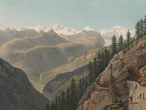
The Val Divedro is the last alpine spectacle in this sequence of views. Thinking they are already in the south, travelers experience the mighty power of mountain nature here once again.


Ort auf moderner Karte
GEOMETRYCOLLECTION (POINT (8.211809 46.205435), LINESTRING (8.211809 46.205435, 8.203056 46.206593))
Camera Settings (3D)
{"landscape":{"viewpoint":{"bounds":[[8.213472026200492,46.19213202391242],[8.227783517557214,46.20949416340443]],"bearing":-73.91236273509686,"pitch":85,"zoom":18.507705528971652,"center":{"lng":8.211802840246492,"lat":46.20545316036112},"cam":{"center":{"lng":8.230250779406845,"lat":46.20155381896399},"zoom":14.361074525068675,"bearing":0},"cameraToCenterDistance":1107.646491440297,"cameraPosition":{"lngLat":{"lng":8.213802950954744,"lat":46.205053946266446},"altitude":629.5958759186547},"cameraTargetElevation":615.5808593746045}},"portrait":{"viewpoint":{"bounds":[[8.21347202619961,46.19213202369505],[8.22778351778382,46.20949416347514]],"bearing":-73.91236273509686,"pitch":85,"zoom":18.507705528971652,"center":{"lng":8.211802840245696,"lat":46.20545316036066},"cameraToCenterDistance":1107.646491440297,"cameraPosition":{"lngLat":{"lng":8.213802950953948,"lat":46.205053946266105},"altitude":629.5958759186548},"cameraTargetElevation":615.5808593746045}},"square":{"viewpoint":{"bounds":[[8.213472026201345,46.19213202388434],[8.2277835175868,46.20949416340633]],"bearing":-73.91236273509686,"pitch":85,"zoom":18.507705528971652,"center":{"lng":8.211802840247401,"lat":46.20545316036021},"cam":{"center":{"lng":8.285029483128739,"lat":46.205766283407854},"zoom":11.618535264471253,"bearing":0},"cameraToCenterDistance":1107.646491440297,"cameraPosition":{"lngLat":{"lng":8.213802950955625,"lat":46.205053946265565},"altitude":629.5958759186549},"cameraTargetElevation":615.5808593746045}}}
Quellen

Voyage pittoresque de Genève à Milan par le Simplon, Paris 1811, Entrée du Vallon de Dovedro

Bilder
nb-479878
Ort
GEOMETRYCOLLECTION (POINT (8.23769 46.208286), LINESTRING (8.23769 46.208286, 8.233056 46.209266))
Titel
Pont sur la Cherasca
Text

Midway between Gondo and Crevoladossola, the Simplon road crosses the Cairasca stream. The accompanying text now points out the noticeably more southerly character of the landscape, where the climate even permits viticulture.


Ort auf moderner Karte
GEOMETRYCOLLECTION (POINT (8.23535 46.208829), LINESTRING (8.23535 46.208829, 8.233577 46.209552))
Camera Settings (3D)
{"landscape":{"camera.fov":60,"image.scale":175,"viewpoint":{"bounds":[[8.241194810965311,46.15206598579877],[8.30214942982019,46.21557970651304]],"bearing":-62.22111415866653,"pitch":85,"zoom":16.518007506460116,"center":{"lng":8.235298991203308,"lat":46.2087646790614},"cam":{"center":{"lng":8.306863877068366,"lat":46.18653916289904},"zoom":12.490396756296498,"bearing":0},"cameraToCenterDistance":1107.646491440297,"cameraPosition":{"lngLat":{"lng":8.242613482909917,"lat":46.20609817760695},"altitude":653.4285267733392},"cameraTargetElevation":597.7707031250011}},"portrait":{"image.scale":190,"viewpoint":{"bounds":[[8.241194810971109,46.15206598595219],[8.302149429803393,46.21557970650662]],"bearing":-62.22111415866653,"pitch":85,"zoom":16.518007506460116,"center":{"lng":8.23529899120922,"lat":46.208764679059556},"cameraToCenterDistance":1107.646491440297,"cameraPosition":{"lngLat":{"lng":8.242613482915914,"lat":46.20609817760513},"altitude":653.4285267733411},"cameraTargetElevation":597.7707031250011}},"square":{"image.scale":181,"viewpoint":{"bounds":[[8.241194810972075,46.15206598555923],[8.302149430085421,46.21557970654857]],"bearing":-62.22111415866653,"pitch":85,"zoom":16.518007506460116,"center":{"lng":8.235298991209675,"lat":46.20876467905833},"cam":{"center":{"lng":8.545967906538777,"lat":46.20492883705194},"zoom":9.527973734341739,"bearing":0},"cameraToCenterDistance":1107.646491440297,"cameraPosition":{"lngLat":{"lng":8.242613482916397,"lat":46.20609817760388},"altitude":653.4285267733424},"cameraTargetElevation":597.7707031250011}}}
Quellen

Voyage pittoresque de Genève à Milan par le Simplon, Paris 1811, Pont sur la Cherasca

Bilder
nb-479879
Ort
GEOMETRYCOLLECTION (POINT (8.299272 46.153071), LINESTRING (8.299272 46.153071, 8.310476 46.150585))
Titel
Vue de l'entrée de la dernière Galerie dessinée du côté du Simplon
Text

In the lower section, the Val Divedro narrows again so much that a final tunnel with a length of 56 m became necessary.


Ort auf moderner Karte
GEOMETRYCOLLECTION (POINT (8.290391 46.155829), LINESTRING (8.290391 46.155829, 8.291132 46.155452))
Camera Settings (3D)
{"landscape":{"image.scale":41,"viewpoint":{"bounds":[[8.266317127926527,46.154935883065974],[8.28992958386803,46.17687817664529]],"bearing":126.33115475045338,"pitch":84.49776545416293,"zoom":18.18223297465754,"center":{"lng":8.291531503200531,"lat":46.15509405401559},"cam":{"center":{"lng":8.29027720568024,"lat":46.16684338507861},"zoom":14.024220921608856,"bearing":0},"cameraToCenterDistance":1107.646491440297,"cameraPosition":{"lngLat":{"lng":8.289431821911506,"lat":46.15616367423917},"altitude":406.5524152134019},"cameraTargetElevation":387.21398925781205}},"portrait":{"image.scale":31,"viewpoint":{"bounds":[[8.270787549493633,46.15531160679757],[8.289900879153066,46.17307356142322]],"bearing":126.33115475045338,"pitch":84.49776545416293,"zoom":18.487201944050412,"center":{"lng":8.291197568178177,"lat":46.15543963895399},"cameraToCenterDistance":1107.646491440297,"cameraPosition":{"lngLat":{"lng":8.289497960945425,"lat":46.15630544950707},"altitude":406.55236825810266},"cameraTargetElevation":390.8987915029667}},"square":{"camera.fov":49,"viewpoint":{"bounds":[[8.251433718602698,46.15604687053906],[8.289617805401974,46.188199338131]],"bearing":126.33115475045338,"pitch":84.49776545416293,"zoom":18.487201944050412,"center":{"lng":8.291197568173175,"lat":46.155439638956295},"cam":{"center":{"lng":8.442354152599165,"lat":46.185344994693736},"zoom":10.202737765092815,"bearing":0},"cameraToCenterDistance":1403.254678080042,"cameraPosition":{"lngLat":{"lng":8.289044370543337,"lat":46.15653651432905},"altitude":410.7299876292378},"cameraTargetElevation":390.8987915029667},"image.scale":43}}
Quellen

Voyage pittoresque de Genève à Milan par le Simplon, Paris 1811, Vue de l'entrée de la dernière Galerie dessinée du côté du Simplon

Bilder
nb-479880
Ort
GEOMETRYCOLLECTION (POINT (8.307911 46.151971), LINESTRING (8.307911 46.151971, 8.305157 46.137749))
Titel
Vue du Pont de Crevola et de la vallée de Domodossola
Text

In stark contrast to the landscape behind, the plain of the Val d'Ossola now stretches out before the traveler. In 1809, the journey from Domodossola over the Simplon to Brig took between 14 and 15 hours. Today, it only takes an hour by car from Domodossola to Brig.


Ort auf moderner Karte
GEOMETRYCOLLECTION (POINT (8.302676 46.153233), LINESTRING (8.302676 46.153233, 8.302617 46.153144))
Camera Settings (3D)
{"landscape":{"viewpoint":{"bounds":[[8.277063930285209,46.15381565781368],[8.62949071296103,46.350431654954605]],"bearing":-153.07673471795783,"pitch":82.4969828122208,"zoom":18.586468747021243,"center":{"lng":8.302301913494034,"lat":46.152684189034346},"cam":{"center":{"lng":8.562354288378884,"lat":46.26059169100219},"zoom":10.8583597056218,"bearing":0},"cameraToCenterDistance":1506.5675879442902,"cameraPosition":{"lngLat":{"lng":8.303510020627897,"lat":46.154332131271076},"altitude":349.1422297035344},"cameraTargetElevation":322.07379771973035},"image.scale":27},"portrait":{"viewpoint":{"bounds":[[8.277063930373174,46.153815657813425],[8.629490713051496,46.35043165487596]],"bearing":-153.07673471795783,"pitch":82.4969828122208,"zoom":18.586468747021243,"center":{"lng":8.302301913494603,"lat":46.15268418903389},"cameraToCenterDistance":1506.5675879442902,"cameraPosition":{"lngLat":{"lng":8.303510020628494,"lat":46.15433213127062},"altitude":349.1422297035346},"cameraTargetElevation":322.07379771973035},"image.scale":27},"square":{"viewpoint":{"bounds":[[8.276917465587331,46.15381551491174],[8.631304358257239,46.351521197600334]],"bearing":-153.0767347176655,"pitch":82.49411788617894,"zoom":18.586459244142247,"center":{"lng":8.30230191349483,"lat":46.15268418903392},"cam":{"center":{"lng":10.048851928936756,"lat":46.375146008473166},"zoom":6.9884559457605,"bearing":0},"cameraToCenterDistance":1506.5675879442902,"cameraPosition":{"lngLat":{"lng":8.303510020628721,"lat":46.15433213127065},"altitude":349.1526846025817},"cameraTargetElevation":322.07379771973035},"image.scale":28,"camera.fov":46}}
Quellen

Johann Gottfried Ebel, Anleitung auf die nützlichste und genussvollste Art die Schweitz zu bereisen, Zurich 1809, vol. 2, p. 466; Voyage pittoresque de Genève à Milan par le Simplon, Paris 1811, Vue du Pont de Crevola et de la vallée de Domodossola

Bilder
nb-479881
Ort
GEOMETRYCOLLECTION (POINT (8.31129 46.148055), LINESTRING (8.31129 46.148055, 8.305497 46.151386))
Titel
Vue du Pont de Crevola
Text

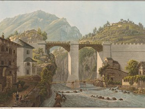
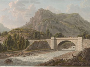
Crevola is the union of two major high Alpine crossings, the Simplon and Gries crossings. The Griesübergang was hardly ever used by travelers, but it was used by muleteers on their way to Valais. 
Both Ebel and the commentator of the Voyage pittoresque describe this bridge as an architectural masterpiece. Pillars over 30 m high support the approximately 45 m long wooden roadway over the river, which is called Diveria here.


Ort auf moderner Karte
GEOMETRYCOLLECTION (POINT (8.301674 46.151311), LINESTRING (8.301674 46.151311, 8.30089 46.15178))
Camera Settings (3D)
{"landscape":{"camera.fov":60,"image.scale":123,"viewpoint":{"bounds":[[8.304168591494886,46.12128608848016],[8.336331199672571,46.15130273635393]],"bearing":-54.06543966745585,"pitch":85,"zoom":17.472650654719455,"center":{"lng":8.301466405391693,"lat":46.151207932036385},"cam":{"center":{"lng":8.336867192342993,"lat":46.13757587350054},"zoom":13.572948578677044,"bearing":0},"cameraToCenterDistance":1107.646491440297,"cameraPosition":{"lngLat":{"lng":8.30492025629394,"lat":46.14947369181763},"altitude":348.4384253813518},"cameraTargetElevation":319.6906250000012}},"portrait":{"image.scale":99,"viewpoint":{"bounds":[[8.304168591491504,46.12128608847462],[8.336331199672514,46.15130273635154]],"bearing":-54.06543966745585,"pitch":85,"zoom":17.472650654719455,"center":{"lng":8.301466405388283,"lat":46.151207932038034},"cameraToCenterDistance":1107.646491440297,"cameraPosition":{"lngLat":{"lng":8.304920256290586,"lat":46.14947369181928},"altitude":348.43842538135095},"cameraTargetElevation":319.6906250000012}},"square":{"camera.fov":60,"image.scale":285,"viewpoint":{"bounds":[[8.308236204286317,46.07101444560129],[8.394655574808866,46.151704220320994]],"bearing":-54.06543966745585,"pitch":85,"zoom":16.046680344468214,"center":{"lng":8.300975561133896,"lat":46.151449487187676},"cam":{"center":{"lng":8.740333056898919,"lat":46.14132145244318},"zoom":9.024354563708856,"bearing":0},"cameraToCenterDistance":1107.646491440297,"cameraPosition":{"lngLat":{"lng":8.31025589118704,"lat":46.146789564342555},"altitude":396.93423292830624},"cameraTargetElevation":319.6906250000012}}}
Quellen

Voyage pittoresque de Genève à Milan par le Simplon, 1811, Vue du Pont de Crevola; Johann Gottfried Ebel, Anleitung auf die nützlichste und genussvollste Art die Schweitz zu bereisen, Zurich 1810, p. 260
 

Bilder
nb-479917
Ort
GEOMETRYCOLLECTION (POINT (8.266108 46.076771), LINESTRING (8.266108 46.076771, 8.256411 46.071889))
Titel
Villa
Text

"These hills and mountains no longer have the barren appearance of Switzerland and Valais; their contours are gentle and the rocks are almost everywhere replaced by fresh, smiling greenery. This place [...] conveys an idea of the difference in the picturesque character of the countries on this side and the other side of the Alps."

Villadossola must have provided Gabriel Lory fils with the only "picturesque" view in the entire Valle d'Ossola. The accompanying text informs us that the rest of the valley no longer offers any points of interest for painting enthusiasts. The well-built plain dominates, the mountains are all pyramid-shaped and of little artistic value.


Ort auf moderner Karte
GEOMETRYCOLLECTION (POINT (8.258035 46.068896), LINESTRING (8.258035 46.068896, 8.257926 46.068832))
Camera Settings (3D)
{"landscape":{"image.scale":73,"viewpoint":{"bounds":[[8.259432285056107,46.068183438911916],[8.289586264135295,46.08642106527009]],"bearing":-137.57188508579156,"pitch":85,"zoom":17.929844398093596,"center":{"lng":8.258049488063762,"lat":46.06890979152843},"cam":{"center":{"lng":8.28459487409367,"lat":46.07808036133946},"zoom":14.29333744583412,"bearing":0},"cameraToCenterDistance":1107.646491440297,"cameraPosition":{"lngLat":{"lng":8.260145746992322,"lat":46.07050093735117},"altitude":313.2300262192769},"cameraTargetElevation":292.2587890623538}},"portrait":{"image.scale":73,"viewpoint":{"bounds":[[8.259432285055937,46.06818343890882],[8.28958626416457,46.08642106528521]],"bearing":-137.57188508579156,"pitch":85,"zoom":17.929844398093596,"center":{"lng":8.258049488063648,"lat":46.06890979152902},"cameraToCenterDistance":1107.646491440297,"cameraPosition":{"lngLat":{"lng":8.260145746992123,"lat":46.07050093735177},"altitude":313.2300262192767},"cameraTargetElevation":292.2587890623538}},"square":{"image.scale":91,"viewpoint":{"bounds":[[8.259885761454655,46.06477901420172],[8.293046781259989,46.08799813294422]],"bearing":-126.41571590071341,"pitch":84.99839025559507,"zoom":18.251809067216453,"center":{"lng":8.258235901594162,"lat":46.069033541041165},"cam":{"center":{"lng":8.425690860481382,"lat":46.08789047414547},"zoom":10.406220911191822,"bearing":0},"cameraToCenterDistance":1282.6385684316433,"cameraPosition":{"lngLat":{"lng":8.26055216911746,"lat":46.07021899579297},"altitude":311.69200231870934},"cameraTargetElevation":292.2587890623538},"camera.fov":53}}
Quellen

Voyage pittoresque de Genève à Milan par le Simplon, 1811, Villa

Bilder
nb-479883
Ort
GEOMETRYCOLLECTION (POINT (8.501711 45.915101), LINESTRING (8.501711 45.915101, 8.539469 45.913727))
Titel
Vue du Pont de Baveno et de l'Isola Madre
Text

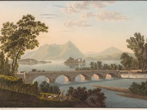
With this view we arrive at Lake Maggiore, about which Ebel writes: "The natural character of this lake is high Alpine wildness combined with the mildness and beauty of the Italian soil and climate, narrow enclosure with wide expanses and distant views."

The road crosses the Selvaspessa here on a five-arched bridge made of white granite with red veins.

Ort auf moderner Karte
GEOMETRYCOLLECTION (POINT (8.500394 45.912544), LINESTRING (8.500394 45.912544, 8.501476 45.91256))
Camera Settings (3D)
{"landscape":{"image.scale":167,"viewpoint":{"bounds":[[8.49583148686665,45.666103805656235],[9.000233572230059,46.08690209093314]],"bearing":87.72751493498457,"pitch":81.38930914114633,"zoom":15.94956092748056,"center":{"lng":8.511099815363877,"lat":45.91237681536663},"cam":{"center":{"lng":8.89926868901469,"lat":45.888599028838996},"zoom":10.386903073960632,"bearing":0},"cameraToCenterDistance":2028.2348761112744,"cameraPosition":{"lngLat":{"lng":8.488836497805067,"lat":45.91176212487238},"altitude":454.02219040599084},"cameraTargetElevation":193.00000000000182},"camera.fov":35},"portrait":{"image.scale":139,"viewpoint":{"bounds":[[8.495592747001012,45.61965935556202],[9.078635729892653,46.1105862503741]],"bearing":88.52751493498455,"pitch":81.88930914114633,"zoom":15.94956092748056,"center":{"lng":8.511099815349326,"lat":45.91237681536086},"cameraToCenterDistance":2028.2348761112744,"cameraPosition":{"lngLat":{"lng":8.488797747897905,"lat":45.91197794793317},"altitude":438.9698564385837},"cameraTargetElevation":193.00000000000182}},"square":{"viewpoint":{"bounds":[[8.495592691901322,45.61964883654048],[9.078656775452345,46.11059336223488]],"bearing":88.5275149350332,"pitch":81.88941178394816,"zoom":15.949561295800942,"center":{"lng":8.511099815345005,"lat":45.91237681536134},"cam":{"center":{"lng":11.41091310965649,"lat":46.06829873107131},"zoom":6.2701267349946646,"bearing":0},"cameraToCenterDistance":2028.2348761112744,"cameraPosition":{"lngLat":{"lng":8.48879774789367,"lat":45.91197794793365},"altitude":438.9667016534529},"cameraTargetElevation":193.00000000000182},"image.scale":162}}
Quellen

Johann Gottfried Ebel, Anleitung auf die nützlichste und genussvollste Art die Schweitz zu bereisen, vol. 3, Zurich 1810, p. 259; Voyage pittoresque de Genève à Milan par le Simplon, 1811, Vue du Pont de Baveno et de l'Isola Madre

Bilder
nb-479884
Ort
GEOMETRYCOLLECTION (POINT (8.514767 45.897019), LINESTRING (8.514767 45.897019, 8.575179 45.912727))
Titel
Vue du Lac Majeur et des Iles Borromées
Text

Lake Maggiore lies between Switzerland and Italy and was used to transport goods from Germany and Switzerland to Italy. The ships sailed up the Toccia and down the Ticino, from where a canal led to Milan, where they transported the region's products, such as coal, wood, hay, white marble from Mergozzo and pink granite from Baveno. In addition to this practical function of transporting goods, Lake Maggiore and its islands were also an important place of inspiration for various writers such as Goethe, Hemingway and Stendhal. The latter liked to repeat: "If you have a heart and a shirt, sell the shirt and look at the shores of Lake Maggiore".


Ort auf moderner Karte
GEOMETRYCOLLECTION (POINT (8.514581 45.892936), LINESTRING (8.514581 45.892936, 8.514699 45.892988))
Camera Settings (3D)
{"landscape":{"viewpoint":{"bounds":[[8.509081922257366,45.888952962026735],[8.682698694754123,45.99471453420969]],"bearing":41.109048143408245,"pitch":70.03107116905272,"zoom":16.555500683988114,"center":{"lng":8.516653511788604,"lat":45.89549676910383},"cam":{"center":{"lng":8.65423452558133,"lat":45.94636676877121},"zoom":11.761044620642707,"bearing":0},"cameraToCenterDistance":2028.2348761112744,"cameraPosition":{"lngLat":{"lng":8.50750370540149,"lat":45.88819885945006},"altitude":584.3165064654368},"cameraTargetElevation":193.00000000000182},"image.scale":201},"portrait":{"viewpoint":{"bounds":[[8.512514269896315,45.89143321035388],[8.553965550773086,45.918676324621174]],"bearing":28.309048145291854,"pitch":67.03042259618626,"zoom":17.486986887420432,"center":{"lng":8.516063480360373,"lat":45.89470880068333},"cameraToCenterDistance":2028.2348761112744,"cameraPosition":{"lngLat":{"lng":8.512673840194651,"lat":45.89032892606372},"altitude":427.4549085782013},"cameraTargetElevation":193.00000000000182}},"square":{"viewpoint":{"bounds":[[8.512221412738285,45.8913194169796],[8.55570815165305,45.918384514207276]],"bearing":37.909048143706514,"pitch":67.02746260060462,"zoom":17.486955294874157,"center":{"lng":8.516063480367961,"lat":45.894708800680604},"cam":{"center":{"lng":8.729655107312283,"lat":45.91998171943305},"zoom":10.015133761433244,"bearing":0},"cameraToCenterDistance":2028.2348761112744,"cameraPosition":{"lngLat":{"lng":8.511671855551327,"lat":45.89078372052475},"altitude":427.48862015146756},"cameraTargetElevation":193.00000000000182}}}
Quellen

Voyage pittoresque de Genève à Milan par le Simplon, Paris 1811, Vue du Lac Majeur et des Iles Borromées; https://www.isoleborromee.it/fr/story/la-storia-visita-palazzo-borromeo/ [26.03.2023]

Bilder
nb-479885
Ort
GEOMETRYCOLLECTION (POINT (8.537158 45.888321), LINESTRING (8.537158 45.888321, 8.52892 45.900687))
Titel
Vue de l'Isola Bella
Text

In 1630, the island was still a rock. The Palazzo Borromeo, which can be seen on this aquatint, was commissioned by Count Borromeo as early as 1632. Napoleon stayed in this palace with his wife Josephine de Beauharnais in 1797. There is still a room named after Napoleon in the palace today. Other famous personalities have stayed at Palazzo Borromeo, such as Johann Wolfgang von Goethe, Stendhal, Ernest Hemingway, Richard Wagner, Queen Victoria and even Prince Charles and Lady Diana.


Aufnahmestandort
nb-479885
Ort auf moderner Karte
GEOMETRYCOLLECTION (POINT (8.535798 45.886006), LINESTRING (8.535798 45.886006, 8.528309 45.894251))
Camera Settings (3D)
{"landscape":{"camera.fov":30,"viewpoint":{"bounds":[[8.273432397446157,42.28059634222208],[12.10123084477047,45.885199145104366]],"bearing":-29.615393714727535,"pitch":85,"zoom":16.901452230344216,"center":{"lng":8.532407412748626,"lat":45.89062033615184},"cam":{"center":{"lng":12.113233725615288,"lat":44.26381343587636},"zoom":6.716243726330901,"bearing":0},"cameraToCenterDistance":2386.6464914402973,"cameraPosition":{"lngLat":{"lng":8.53915583024849,"lat":45.88235649424428},"altitude":285.4669008396782},"cameraTargetElevation":193.00000000000182},"image.scale":82},"portrait":{"viewpoint":{"bounds":[[7.726986527692958,45.884312075416545],[8.598461902706845,46.67276161989378]],"bearing":-29.61539371455478,"pitch":84.5,"zoom":17.311676300019773,"center":{"lng":8.533213384119335,"lat":45.889253393448655},"cameraToCenterDistance":2386.6464914402973,"cameraPosition":{"lngLat":{"lng":8.538287541634844,"lat":45.883039745046375},"altitude":269.521610786177},"cameraTargetElevation":193.00000000000185},"image.scale":41},"square":{"viewpoint":{"bounds":[[8.479699637480138,45.701540077541665],[8.718561796105547,45.88615353824102]],"bearing":-24.815393714801985,"pitch":85,"zoom":17.74495440718355,"center":{"lng":8.53381448563141,"lat":45.88901564297211},"cam":{"center":{"lng":9.674010430607325,"lat":45.877133302500624},"zoom":7.557602876090249,"bearing":0},"cameraToCenterDistance":2028.2348761112744,"cameraPosition":{"lngLat":{"lng":8.536528838172785,"lat":45.88492949931518},"altitude":236.79348857351516},"cameraTargetElevation":193.00000000000182},"image.scale":40}}
Quellen

Voyage pittoresque de Genève à Milan par le Simplon, Paris 1811, Vue de l'Isola Bella; https://www.isoleborromee.it/fr/story/la-storia-visita-palazzo-borromeo/ [26.03.2023]
 

Bilder
nb-479886
Ort
GEOMETRYCOLLECTION (POINT (8.541962 45.887224), LINESTRING (8.541962 45.887224, 8.518192 45.900277))
Titel
Vue de l'Isola Bella prise de Stresa
Text

From Stresa, people were ferried to the Borromean Islands, as evidenced by the boat landing stage.


Aufnahmestandort
nb-479886
Ort auf moderner Karte
GEOMETRYCOLLECTION (POINT (8.543844 45.883171), LINESTRING (8.543844 45.883171, 8.543361 45.88338))
Camera Settings (3D)
{"landscape":{"camera.fov":37,"image.scale":89,"viewpoint":{"bounds":[[8.54434071155606,45.57509558176977],[8.9055375763362,45.88376477748392]],"bearing":-42.455117022038905,"pitch":85,"zoom":16.536703270280157,"center":{"lng":8.537959470587566,"lat":45.88832791375464},"cam":{"center":{"lng":8.894570834469135,"lat":45.74279858015069},"zoom":10.221300473882128,"bearing":0},"cameraToCenterDistance":1911.26403367408,"cameraPosition":{"lngLat":{"lng":8.547464763891583,"lat":45.881095712682225},"altitude":288.3536221452965},"cameraTargetElevation":193.00000000000182}},"portrait":{"viewpoint":{"bounds":[[8.543630754444536,45.57488869941258],[8.904827612902665,45.88355903178504]],"bearing":-42.455117022038905,"pitch":85,"zoom":16.536703270280157,"center":{"lng":8.537249513477178,"lat":45.888122184954995},"cameraToCenterDistance":1911.26403367408,"cameraPosition":{"lngLat":{"lng":8.546754806781223,"lat":45.88088995709805},"altitude":288.35397531047414},"cameraTargetElevation":193.00000000000182},"image.scale":81},"square":{"viewpoint":{"bounds":[[8.543630754440528,45.57488869764563],[8.90482761499311,45.88355903178754]],"bearing":-42.455117022038905,"pitch":85,"zoom":16.536703270280157,"center":{"lng":8.537249513472943,"lat":45.88812218495798},"cam":{"center":{"lng":10.349615057203465,"lat":45.85536110752639},"zoom":6.960995837946708,"bearing":0},"cameraToCenterDistance":1911.26403367408,"cameraPosition":{"lngLat":{"lng":8.546754806776988,"lat":45.88088995710103},"altitude":288.353975310469},"cameraTargetElevation":193.00000000000182},"image.scale":79}}
Quellen

Johann Gottfried Ebel, Anleitung auf die nützlichste und genussvollste Art die Schweitz zu bereisen, vol. 4, Zurich 1810, p. 243

Bilder
nb-479887
Ort
GEOMETRYCOLLECTION (POINT (8.546013 45.778566), LINESTRING (8.546013 45.778566, 8.563175 45.757252))
Titel
Vue d'Arona
Text

Click on "Open image details" for more information.

Aufnahmestandort
nb-479887
Ort auf moderner Karte
GEOMETRYCOLLECTION (POINT (8.5445 45.773979), LINESTRING (8.5445 45.773979, 8.545094 45.773278))
Camera Settings (3D)
{"landscape":{"viewpoint":{"bounds":[[8.45764396073264,45.775704584992525],[8.568253974203714,45.85947918716499]],"bearing":153.42694546996916,"pitch":84.99812957515547,"zoom":18.389205665254643,"center":{"lng":8.544493317601223,"lat":45.77399448702897},"cam":{"center":{"lng":8.559060664952256,"lat":45.82117833797105},"zoom":12.100501511694889,"bearing":0},"cameraToCenterDistance":1911.26403367408,"cameraPosition":{"lngLat":{"lng":8.542748982114347,"lat":45.7764268990702},"altitude":226.48427397264527},"cameraTargetElevation":200.01557617187538},"image.scale":50},"portrait":{"viewpoint":{"bounds":[[8.467852095276129,45.77588063577929],[8.585097163464212,45.85635291661376]],"bearing":161.4269454700402,"pitch":84.99802115910894,"zoom":18.389205426311182,"center":{"lng":8.544493317609295,"lat":45.77399448702269},"cameraToCenterDistance":1911.26403367408,"cameraPosition":{"lngLat":{"lng":8.543251317527847,"lat":45.776572545906674},"altitude":226.48485061003262},"cameraTargetElevation":200.01557617187538}},"square":{"viewpoint":{"bounds":[[8.22355145157573,45.775866958940554],[8.781621697484638,46.13416606374935]],"bearing":166.2269454702462,"pitch":83.9846954392409,"zoom":18.38920978647211,"center":{"lng":8.544493317605884,"lat":45.77399448703184},"cam":{"center":{"lng":11.0139026811203,"lat":46.14895717034872},"zoom":6.333334461553309,"bearing":0},"cameraToCenterDistance":1911.26403367408,"cameraPosition":{"lngLat":{"lng":8.543566554888088,"lat":45.77663148021426},"altitude":231.82898344631258},"cameraTargetElevation":200.01557617187538}}}
Bilder
nb-479888
Ort
GEOMETRYCOLLECTION (POINT (8.638783 45.723245), LINESTRING (8.638783 45.723245, 8.618867 45.72847))
Titel
Vue de Sesto
Text

In the summer of 1809, when Gabriel Lory fils and Maximilien de Meuron were staying on Lake Maggiore, there was still no bridge over the Ticino at Sesto Calende. Instead, a ferry connected the two sections of road coming from the Simplon and leading to Milan.
Here, at the southern end of the lake, the view back to the north reminds us of the journey: we have crossed the Alpine chain with the Monte Rosa massif at its center to now linger in the sunny south.


Ort auf moderner Karte
GEOMETRYCOLLECTION (POINT (8.627207 45.722488), LINESTRING (8.627207 45.722488, 8.62666 45.722638))
Camera Settings (3D)
{"landscape":{"viewpoint":{"bounds":[[8.632265142714857,31.502760880308628],[28.1549734011233,45.72602587096307]],"bearing":-64.55211614347525,"pitch":85,"zoom":14.80038630570242,"center":{"lng":8.595190272749846,"lat":45.733105287279784},"cam":{"center":{"lng":25.417900346545878,"lat":39.574260448732105},"zoom":4.849427522708367,"bearing":0},"cameraToCenterDistance":2386.6464914402973,"cameraPosition":{"lngLat":{"lng":8.648093368449025,"lat":45.71553072267963},"altitude":590.8308313054835},"cameraTargetElevation":193.0000000000018},"camera.fov":30,"image.scale":300},"portrait":{"viewpoint":{"bounds":[[8.632265142712953,31.50276017813215],[28.154974280278196,45.726025870962815]],"bearing":-64.55211614347525,"pitch":85,"zoom":14.80038630570242,"center":{"lng":8.595190272747459,"lat":45.7331052872801},"cameraToCenterDistance":2386.6464914402973,"cameraPosition":{"lngLat":{"lng":8.648093368446581,"lat":45.715530722679944},"altitude":590.8308313054812},"cameraTargetElevation":193.0000000000018},"camera.fov":30,"image.scale":300},"square":{"viewpoint":{"bounds":[[8.632265142716335,31.50276025206331],[28.154974324384284,45.72602587096148]],"bearing":-64.55211614347525,"pitch":85,"zoom":14.80038630570242,"center":{"lng":8.595190272750642,"lat":45.733105287278164},"cam":{"center":{"lng":106.24581105105597,"lat":46.147472091662365},"zoom":1.2047717307264392,"bearing":0},"cameraToCenterDistance":2386.6464914402973,"cameraPosition":{"lngLat":{"lng":8.648093368449793,"lat":45.71553072267801},"altitude":590.8308313054949},"cameraTargetElevation":193.0000000000018},"camera.fov":30,"image.scale":300}}
Quellen

Marie-Louise Schaller, Voyage pittoresque de Genève à Milan, in: Voyage pittoresque de Genève à Milan 1800-1820, (exhib. cat. Swiss PTT Museum 1994), pp. 37-68, Voyage pittoresque de Genève à Milan par le Simplon, Paris 1811, Vue de Sesto

Marie-Louise Schaller, Voyage pittoresque de Genève à Milan,in: Voyage pittoresque de Genève à Milan 1800-1820,(exhib. cat. Swiss PTT Museum 1994), pp. 37-68

Bitte berühren!