In 1863, there was a steamboat connection between Lucerne and Flüelen, which ran 4-5 times a day. The first ship departed in the early hours of the morning at 5.15 am, followed by two ships at 8.15 am and 10.15 am. In the afternoon there were two trips, one at 2:30 pm and the last trip of the day at 4:15 pm. The journey took 2 hours and 45 minutes, and this time is still the same today.
Luggage, on the other hand, was taxed and weighed on board, which meant additional costs on top of the ticket. The price in first class to Flüelen was CHF 4.60 (the equivalent of around CHF 69 today), for second class CHF 2.30 (the equivalent of around CHF 34.50 today), but Karl Baedeker recommended traveling in second class as the view was better there. However, in the author's opinion, the lunches were not the best!
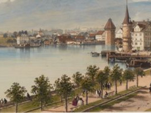
Surprisingly, Baedeker did not recommend Lucerne for a longer stay, as in his opinion the city was not very attractive despite its enchanting location. Today, Lucerne is one of the most visited Swiss cities.
Karl Baedeker, La Suisse et les parties limitrophes de l'Italie, de la Savoie et du Tyrol. Manuel du voyageur en Suisse, Koblenz, 1863, p. 73
"According to the announcement, printed in 1838, the steam-boat "La Ville de Lucerne" will run from Lucerne to Flüelen and back eight times a week during the summer (from June 1 to September 30), and five times a week in the spring and autumn. It will touch at Altstadt, Weggis, Vitznau, Bechenried, Gersau, Brunnen, Flüelen, Stanzstadt, and Alpnach. The fare to Flüelen is 3f. 20 raps Swiss, and less in proportion to the intermediate stations. The voyage will take up about three hours."
Many travelers used this station to get to Mount Rigi on foot. From Lucerne, it took 4.5 hours to reach the summit of the Rigi: 45 minutes by steamboat to Weggis and then 3.5 hours to the Rigi. Karl Baedeker recommends reaching the summit at least an hour before sunset to enjoy the spectacle.
Travellers who wanted to continue their journey beyond the Rigi to the St. Gotthard sent their luggage to the main office in Altdorf in advance so that they did not have to carry heavy loads as they climbed the Rigi.
John Murray and Son, The Hand-Book for Travellers in Switzerland and the Alps of Savoy and Piedmont, 2nd edition, London/Paris 1840, p. 71; Karl Baedeker, La Suisse et les parties limitrophes de l'Italie, de la Savoie et du Tyrol. Manuel du voyageur en Suisse, Koblenz 1863, p. 51 and 58
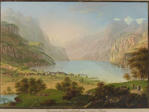
"Beckenried or Beggenried (inns Sonne, Mond), on the lake, once the meeting place of the four forest cantons for joint consultations, is the landing place for steamboats for travelers who want to go to Buochs, 1 hour from Beckenried, and Stans [...], 2 hours from Beckenried." There is still no sign of a landing stage for steamboats on this view from 1817. This is because steamboat travel on Lake Lucerne only began 20 years later, in 1837.
Karl Baedeker, Die Schweiz. Handbüchlein für Reisende, nach eigener Anschauung und den besten Hülfsquellen bearbeitet, Koblenz 1844, p. 113; Hans Stadler, "Vierwaldstättersee", in: Historisches Lexikon der Schweiz (HLS), version of 27.02.2013. [01.07.2024]
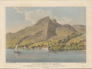
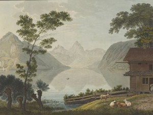
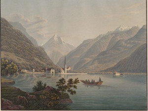
Before the advent of steam navigation, travelers had to rely on rowing and sailing boats, as we see in this view from the 1780s off the village of Gersau. Travel writers of the time described navigation on Lake Lucerne as extremely dangerous and terrifying.
Johann Gottfried Ebel, however, reassured tourists in the first edition of his famous travel guide: "But if you have a boat that is not too small and good, not drunken boatmen, the traveler happily escapes the black gorges that open a thousand times with foaming fury. The skippers with whom I sailed on this lake several times assured me that if an accident happened, it was always due to the drunkenness of the helmsmen and rudders." Perhaps people boarded a ship back then with similar feelings to those we experience today before a rollercoaster ride.
Johann Gottfried Ebel, Anleitung auf die nützlichste und genussvollste Art in der Schweitz zu reisen, Zurich 1793, p. 177
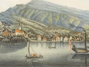
Brunnen was described as a place teeming with ships, which was rather touristy at the time and recommended for a longer stay. Travelers who wanted to travel by boat from Brunnen to Flüelen could hire a large or small boat. The large one cost CHF 14 and even had room for a carriage, and the small one cost CHF 9. These costs are equivalent to between CHF 135 and 210 today.
Karl Baedeker, La Suisse et les parties limitrophes de l'Italie, de la Savoie et du Tyrol. Manuel du voyageur en Suisse, Koblenz 1863, p. 78

From 1865, travelers and goods between Brunnen and Flüelen no longer crossed Lake Uri, but instead used the newly opened Axenstrasse. Previously, this route had only been accessible on arduous mule tracks and transportation by water was much cheaper and faster. To this day, the constant danger of falling rocks has led to numerous closures of the road, which passes through numerous galleries and tunnels. Recently, new bypass tunnels have been underway and are due to be opened by 2029.
Flüelen served as a landing point for all travelers arriving in the canton of Uri on the Gotthard route. The Zum weissen Kreuz inn was considered one of the most excellent in the whole country. A large part of the population made a living from shipping, which was subject to the strict rules of the shipping company.
In addition to the mail boat, which was also allowed to transport travelers from Flüelen to Brunnen, there was a shipping company that operated the Ury-Nauen to Lucerne on Monday mornings and back on Wednesdays. Goods and passengers were transported on it, with a superstructure in the middle of the ship to protect them from wind and rain. The large Nauen was operated with 9 rowers. The journey with the Nauen from Flüelen to Lucerne and in the opposite direction took between 8 and 10 hours - a route that the steamboat, which had been operating on the lake since 1838, completed in just 2 hours and 45 minutes.
Johann Gottfried Ebel, Anleitung, auf die nützlichste und genussvollste Art die Schweiz zu bereisen, Zurich 1809-1810, vol. 2, p. 304; M. Kälin and J. Suter, Ansichten der neuen St. Gotthards-Strasse von Flüelen bis Lugano, Zurich 1833, p. 34; Karl Baedeker, La Suisse et les parties limitrophes de l'Italie, de la Savoie et du Tyrol. Manuel du voyageur en Suisse, Koblenz, 1863, p. 86; Stefan Fryberg, Verkehrswege in Uri - Der Urnersee, Altdorf 1993
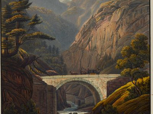
In 1822, the Pfaffensprung Bridge was widened to allow carriages to cross the Reuss. The entire Gotthard route from Flüelen to Lugano was also widened by 1830 to make it roadworthy and catch up with the competition from the other Alpine passes.

In the 19th century, there were two ways to get to Andermatt, the route over the Gotthard Pass and a second, much more arduous route that led from Andermatt to Airolo. The latter was only accessible in summer.
Both Ebel and Baedeker recommend staying at the Hotel Drei Könige in their travel guides. This hotel, which is still in operation today, also offered the opportunity to dine there while changing horses. You had to pay Fr. 3 (around CHF 45) for dinner and changing horses, Fr. 1.50 (around CHF 22.50) for an overnight stay and Fr. 1 (around CHF 15) for breakfast. Today, the lowest price for a single room in this hotel is around CHF 145.
Johann Gottfried Ebel, Anleitung, auf die nützlichste und genussvollste Art die Schweiz zu bereisen, Zurich 1809-1810, vol. 2, p. 87; Karl Baedeker, La Suisse et les parties limitrophes de l'Italie, de la Savoie et du Tyrol. Manuel du voyageur en Suisse, Koblenz 1863, p. 85
Airolo is the first village on the route where Italian is spoken. Johann Gottfried Ebel emphasized that the people in the valley beyond Airolo spoke a corrupt Italian. As he was otherwise familiar with the Swiss dialects as a peculiarity of the country, this negative assessment of this Ticino dialect is surprising. However, most of the innkeepers on the Gotthard route were perfectly capable of communicating in German.
It took about 1.5 hours to walk from the hospice on the pass to Airolo, twice as long for the ascent. In his travel guide, Karl Baedeker did not necessarily recommend stagecoaches, as they did not travel any faster.
Johann Gottfried Ebel, Anleitung, auf die nützlichste und genussvollste Art die Schweiz zu bereisen, Zurich 1809-1810, vol. 2, pp. 18-19; Karl Baedeker, La Suisse et les parties limitrophes de l'Italie, de la Savoie et du Tyrol. Manuel du voyageur en Suisse, Koblenz 1863, p. 87
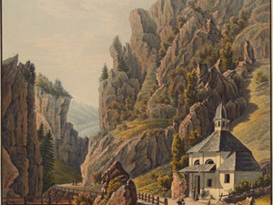
Only a few visible traces of the old road through the gorge at Stalvedro remain today:
"Below Brugnasco, a hill jutting out from the foot of the Tonjio seems to block the road, but it squeezes through the moraine-like gorge called Stretto die Stalvedro close to the Ticino. This gorge is dominated by an old tower built by the Lombard king Desiderio in 774. Since these walls were built, how many a man has passed by there, happy and cheerful, only to find his unexpected death shortly afterwards on the crossing over the St. Gotthard due to frost, avalanches or snowstorms!"
The Inventory of Historic Traffic Routes in Switzerland IVS describes the section of the road under the number TI 4.5.13. It is assumed that the course of the road followed the old mule track, the so-called Mulattiera Urana (Strada Urana). Remains of this road can also be seen in the gorge below Dazio Grande.
Ansichten der neuen St. Gotthards-Strasse von Fluelen bis Lugano / nach der Natur gezeichnet und geäzt von M. Kälin und J. Suter, nebst einer Beschreibung von Herrn Lusser M.D. aus Altdorf, Zürich: bey Heinrich Füssli und Comp., Kunsthandlung zur Meisenzunft, 1833, pp. 45-46; Federal Inventory of Historic Transport Routes in Switzerland (IVS), TI 4.5.13 (PDF) [16.11.2023]
While the famous Gotthard Post did not start operating until 1835, private coachmen were already offering their services when the new road opened in 1830. Here we see a two-axle coach drawn by four horses, which perhaps had room for eight people (including the coachman).
The actual Gotthard Post then ran with two or five horses, depending on the load, and could transport up to ten people at an average speed of around 9 km/h. From 1842, these ten-seater express coaches, as they were called in the guidebooks, ran daily between Flüelen and Chiasso.
The journey took around 28 hours and passed 15 customs stations. And at the Gotthard hospice, the travelers still had to change coaches, namely from the Uri to the Ticino stagecoach, whereby all luggage had to be reloaded!
Thomas Frey, Eine funktionale Bestandsaufnahme der Pferdepost, 1850-1920, in: Traverse, vol. 6 (1999), pp. 91-92 [04.07.2024]; Bundesinventar der historischen Verkehrswege der Schweiz (IVS), UR 3.4 (PDF) [22.04.2024]; Karl Baedeker, Die Schweiz. Handbook for travelers, edited from his own experience and the best sources, Koblenz 1844, pp. 209-210
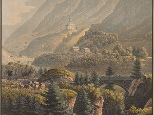
Johann Gottfried Ebel recommends that travelers spend the night at the Zur Sonne inn, which is in a good and beautiful location. He emphasized that not all houses in Faido were equipped with stoves for heating, which was somewhat surprising considering the harsh winters in the valley. Travelers going from Faido to Dazio or vice versa had to pay a small toll, as the upgrade of the road through the gorge between the two towns had been extremely expensive.
Johann Gottfried Ebel, Anleitung, auf die nützlichste und genussvollste Art die Schweiz zu bereisen, Zurich 1809-1810, vol. 2, pp. 444 and 524
In 1863, stagecoaches ran twice a day from Lucerne over the St. Gotthard to Bellinzona. The journey took 18 hours by stagecoach. Today, a train travels from Lucerne to Bellinzona through the Gotthard Base Tunnel in just 1 hour and 26 minutes!
Karl Baedeker, La Suisse et les parties limitrophes de l'Italie, de la Savoie et du Tyrol. Manuel du voyageur en Suisse, Koblenz 1863, p. 391
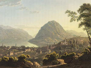
Before reaching Lugano, the Monte Ceneri had to be conquered. Not only was this strenuous on foot, but you also had to arm yourself against numerous highwaymen who - hidden in hollow chestnut trees - could suddenly pounce on the travelers.
Heinrich Heidegger, Handbuch für Reisende durch die Schweiz, 2nd edition, Zurich 1791, vol. 1, p. 13
Once you had crossed the border to Austria in Chiasso, you were almost in Como. At the time this view was created around 1822, Lombardy belonged to the Lombardo-Venetian Kingdom, which in turn was part of the Austrian Empire. In Como, goods coming from the north over the Splügen Pass met those from the Gotthard route.
The town had around 20,000 inhabitants and was known both for its sights and its picturesque location at the southern end of the lake of the same name. It had a thriving silk industry and also produced a special black soap. In 1853, there was a daily omnibus service, a coach with ten seats, to Lugano.
Johann Jakob Wetzel, Voyage pittoresque au Lac de Come, Zurich 1822, pp. 26-31; Karl Baedeker, Handbuch für Reisende in Deutschland und dem österreichischen Kaiserstaat. Nach eigener Anschauung und den besten Hülfsquellen (Erster Theil): Österreich, Süd- und Westdeutschland, p. 208
HLS DHS DSS, "Gotthard Pass", in: Historisches Lexikon der Schweiz (HLS), version of 30.08.2016, translated from Italian. [08.07.2024]; Hans Stadler, "Vierwaldstättersee", in: Historical Dictionary of Switzerland (HLS), version of 27.02.2013. [01.07.2024]