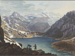
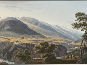
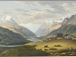
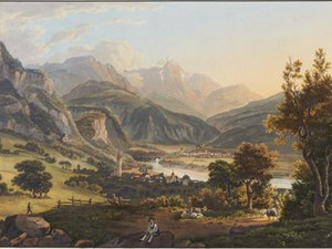
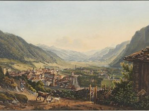
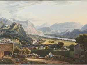
The outflow of the Vorderrhein from Lake Toma was already regarded as the actual source of the Rhine in the early 19th century. We can also see this from the placement of the view of Lake Toma at the beginning of the Grosses Rheinwerk. Situated slightly off the Oberalp Pass, traders and muleteers were the only visitors to the area for a long time. Over the course of the 18th century, several Zurich naturalists, painters and priests made excursions to the Surselva, but the first view of Lake Toma was by the Mannheim theater painter Johann Georg Primavesi (1774-1855), who wrote in 1818:
"What a sight! A lake 400 steps long and 200 steps wide at this immense height, and yet surrounded by mountains. On one side the Badus, on the other bare and mossy rocks, in some places snow down to the lake. The water is dark blue, green, purple and clear everywhere, down to a depth of more than 20 feet. This is the view you get when you reach the hill on which the two figures are on the second plate. This lake is formed by the confluence of the three streams that can be seen on the first plate."
Albert Lutz, Val Medel. Naturforscher und Landschaftsmaler erkunden den Rhein und die Berge am Lukmanier, 1700-1830, Curaglia 2024 (Neujahrsblatt der Gelehrten Gesellschaft in Zürich auf das Jahr 2024, 187. Stück), pp. 9-10; 32-33; Johann Georg Primavesi, Der Rheinlauf, von dessen verschiedenen Quellen bis zur Vereinigung des Vorder- und Hinter-Rheins bei Reichenau, Frankfurt a. M. 1818, p. 4
The English painter William Tombleson (1795-1846) visited the Rhine Spring regions in the 1820s:
"After visiting the diminutive Lake of Toma, into which fall three rivulets from the snow-fields of the Badus, and form a reservoir ni its rocky bed, 400 paces long, 200 paces wide and 20 feet deep in its rocky bed, we proceeded to the little village of Ciamut, the first place, at the entrance of the valley where any kind of grain can be raised. The industry and perseverance of the inhabitants here are often rendered profitless by the long duration and severity of the winters and the frequent visitations of avalanches, destructive alike to property and human existence."
William Tombleson, Tombleson's Upper Rhine, London 1832, p. 166
Very few travelers visited the source of the Medelserrhein (also known as Froda ) near the lakes of Val Cadlimo. Louis Bleuler was the first to describe this area. The remote valley is also mentioned in the travel guide of the German doctor Johann Gottfried Ebel (1764-1830), who lived in Zurich, in 1810. In some cases the names, which were probably given by Father Placidus a Spescha from Disentis, can no longer be precisely assigned today:
"Val Kadelima (Kadelina, Kurlima, Kurlim), which takes its name from Ka d'ol Rhin, i.e. the head of the Rhine, begins just half an hour west of St. Maria. It is 12 hours long as far as Lake Dim, which is the source of the Middle Rhine. This lake does not thaw completely in some summers. The small stream flowing out of it joins with another from Lake Skur to form Lake Insla (Italian: Isola). The stream, called Froda, flows out of it, takes up the Termser stream, near St. Maria the Radicer stream, and now flows as the Middle Rhine through the Medels valley ([...]. If you walk from St. Maria into the Cadelin valley, the Piz, Kurlim, Kadajn and Pegora, all three together called la Sceina de Kurlim or Kadlim (Italian Skanadu), stand in the rocky chain on the left. In a dark depression lies Lake Pegore, which empties into Lake Kadajn in the Piora valley. Then follows Piz Scur, actually called Piz Tom; a few steps from Lake Scur lies a small Lake Pign, which empties into Lake Tom in the Piora valley. To the south of Lake Dim rises Piz Teneda, which closes the Kadelin valley and separates it from the Canaria valley. It is not far from Lake Dim to the height of Teneda, where the Canaria valley (a tributary valley of the Upper Livenen in Canton Ticino) is overlooked, but the side of the valley is covered with snow. To the NW. the Pontenära rocks stand between the Canaria, Cadelin, Cornero and Unter-Alp valleys, so that streams flow from the snow and ice of these rocks standing in the Alpine ridge to Ticino as well as to the Reuss and the Rhine. If you want to enjoy a remarkable view of nature in the high mountains, climb the hill between Canaria and Cadelinthal, or Piz Scuro between Lake Scur and Pegore, or Pontenära; this last rock is best climbed from the north-western side, but the weather must be clear."
Johann Gottfried Ebel, Anleitung, auf die nützlichste und genussvollste Art die Schweitz zu bereisen, vol. 3, Zurich 1810, pp. 391-392
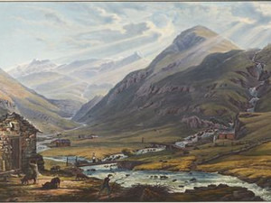
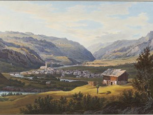
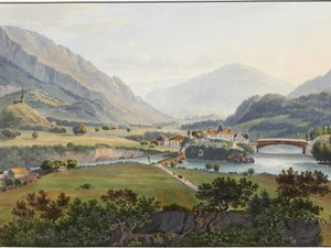
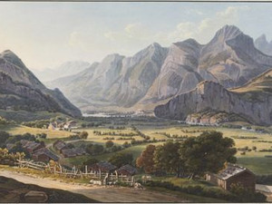
Travelers in the 19th century could still see the Val Medel without a reservoir. This was created in 1968 and flooded the hamlet and chapel of Sontga Maria.
„This interesting valley is in the superior league of the Grisons, lying in a south-western direction, from the valley of Tavetsch to mount Lukmanier, being seventeen miles in length. The inhabitants (who amount to about 600) are industrious, and expert in the manufacture of wooden ware. Notwithstanding the great elevation of this wild and narrow glen, it admits the growth of wheat, barley, and fruit-trees, and affords excellent pasturage. The streams which form the middle Rhine issue from the little lakes Dim, Scur and Insla, in the sterile valley of Kadelin, or Curlim, lying between the Piz-Curlim, Piz-Scur, Piz-Teneda, Piz-Pentenära, and Piz-Blar, near the confines of the canton of Tessin. Escaping from the snowy deserts by a magnificent fall, the incipient river rushes through the Alpine pastures of the Lukmanier defile, at the foot of the Scopi glacier, joins the rivulet Cristalina, and, near Stinesh, under the appellation of Médelser-Rhem, proceeds gaily in its course, throws its bright waters sportively over craggy precipices, and forms, at times, cascades of extraordinary beauty. The valley contains one small town and four villages. At its upper extremity is the monastery of Santa Maria [...].“
William Tombleson, Tombleson's Upper Rhine, London 1832, p. 169
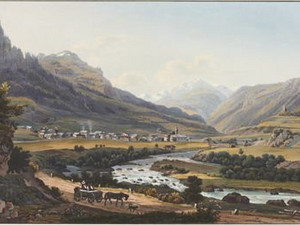
Around 700, Sigisbert, a monk from the Luxeuil monastery in the Vosges, built a cell on this site. He received support from the local landlord Placidus. From around 750, Disentis developed into a large monastery, which in 810 was already home to 71 monks. It was from here that the Surselva was cultivated. As the valley town of the Oberalp and Lukmanier passes, it occupied an important position in terms of transportation. In 1774, Placidus Spescha joined the monastery, who would go on to have a significant influence on tourists' image of the Grisons mountains. He was the first to climb numerous peaks in the region, explored the mountain nature and guided scientists and artists to the most interesting spots. This included Louis Bleuler, to whom he showed the Rhine springs, as well as Samuel Birmann and William Tombleson.
William Tombleson tells us the following about Disentis:
"The village has recovered, in great part, its former beauty and prosperity; numerous herds are seen grazing around; the songs of the milk-maids resound in the valley, and the blessings of peace seem to have obliterated the remembrance of the ravages of war; the fat cheeses of Disentis are as celebrated as ever, and the few remaining monks of the abbey are consoled for their losses by the kindness of the inhabitants, which their present modest bearing appears to merit. On the raising of cattle depends the prosperity of the villagers, whose industry and experience, with good pastures, afford them great advantages. It is impossible to conceive any thing more beautifully and sublimely diversified than the view from this place: colossal mountains and towering glaciers on one side, contrasting singularly with verdant meadows, fruitful valleys, rippling brooks, and all that soft variety which Nature, in her kondest mood, spreads on the face of the earth; the Rhine, flowing joyously along, to accomplish its important mission."
William Tombleson, Tombleson‘s Upper Rhine, London 1832, p. 160-161; Daniel Schönbächler, Disentis, in: Historisches Lexikon der Schweiz (HLS), Version vom 17.03.2010. [12.01.2026]; Urban Affentranger, Spescha, Placidus, in: Historisches Lexikon der Schweiz (HLS), Version vom 08.01.2013. , [12.01.2026]; Albert Lutz, Val Medel. Naturforscher und Landschaftsmaler erkunden den Rhein und die Berge am Lukmanier, 1700–1830, Curaglia 2024 (Neujahrsblatt der Gelehrten Gesellschaft in Zürich auf das Jahr 2024, 187. Stück); Ursula Scholian Izeti (Hrsg.), Placidus Spescha, Genaue geographische Darstellung aller Rheinquellen [...] (Manuskript 1823), Zürich 2005, pp. 12-13
The Medels Rhine flows into the Vorderrhein near Disentis. Measured by the length of the watercourse to its mouth at the Hoek van Holland, the source of the Medels Rhine in Val Cadlimo should be considered the main source. This is 1238 km. Lake Toma was long regarded as the actual source of the Rhine, but the Vorderrhein, which rises there, is five kilometers shorter. Depending on the criterion, numerous bodies of water can be considered "actual" Rhine source streams: If one takes the volume of water, the source of the Dischma stream at the Scaletta Pass in the municipality of Davos would have to be considered the source of the Rhine, as this supplies more water to the Landwasser than the latter has at this point, the Landwasser more than the Albula, the Albula more than the Hinterrhein. The Aare is also more powerful than the Rhine at its mouth. According to this logic, the glacier tongue of the Aare glacier would therefore be the actual source of the Rhine.
Page "Rheinquelle". In: Wikipedia - The free encyclopedia. Edit status: October 13, 2025, 21:50 UTC. [12.01.2026]

Johann Gottfried Ebel already found Trun quite beautiful, but at the same time proposed measures to further improve the quality of life in the village:
"Trons lies two quarters of an hour from the Rhine, is the most beautiful and fertile place in the high court of Disentis, and enjoys a picturesque location and the most beautiful views in the Vorder-Rheinthal. If the marshy plain below the village were cleared of stones and bushes and cultivated, the location of Trons would become even healthier and the inhabitants more prosperous."
Johann Gottfried Ebel, Anleitung, auf die nützlichste und genussvollste Art die Schweitz zu bereisen, vol. 4, Zurich 1810, p. 369

Johann Gottfried Ebel found the frequent occurrence of goitres in the population of Ilanz remarkable, a pathological enlargement of the thyroid gland caused by a lack of iodine in the diet. He also emphasizes the importance of the town as a suburb of the Grauer Bund, an association of municipalities in the Vorder- and Hinterrheintal and Misox, which had existed since 1395 and later gave its name to the canton of Graubünden.
"ILANZ, (Rhaet. Ilan or Jlon) in K. Graubündten, at the foot of the Mundaun or Karlisberg in the extended valley called the Grube, between the Vorder-Rhein and Glenner, which flows out of the Lugnetzer-Thale from the south. Wirthshaus: Bey Fr. Stutli or im Neuen Haus, or in the Lowen outside the town. It is the first town on the Rhine and the only one that speaks Romansh. It has two suburbs: S. Nicolai and Portasura. The bridge over the Rhine is worth seeing here. The citizens are Protestants. On September 29 there is a very large cattle market here. There are many goitres among the women of Ilanz, as well as in the vicinity, where the valley narrows. Ilanz is the capital of the high court of Grub (rhät. la Fopa), which is so called because its villages lie in a hollow. The appellate court of the Grauen-Bund is held here alternately with Thusis and Trons. The archives of the Grauen-Bund are here. [...] Delicious trout weighing 20-24 pounds are caught near Ilanz."
.
Johann Gottfried Ebel, Anleitung, auf die nützlichste und genussvollste Art die Schweitz bereisen, vol. 3, Zurich 1810, p. 208; Claudine Als, Kretinismus, in: Historisches Lexikon der Schweiz (HLS), version of 04.11.2008. [10.01.2026]; Martin Bundi, Grauer Bund, in: Historical Dictionary of Switzerland (HLS), version of 14.01.2010. [11.01.2026]
In 1760, Gottlieb Sigmund Gruner (1717-1778) reported the following about the origin of the Hinterrhein, using the terms "evening", "midday" and "midnight" for cardinal points and "hours" to indicate distance. One hour corresponds to 15,000 to 18,000 feet, i.e. around 4.5 to 5.2 kilometers.
"The actual and true source of the Rhine is not easy to determine. If you walk in the Rhine forest from the village zum Rhein for a few hours towards evening, through the Paradise, following the course of the Rhine, which is only a small stream there, you will see, as you thought, nothing but glaciers, snow and ice, and water trickling down from them in various places, which is nothing more than meltwater and disappears again in winter. On the other hand, behind these glaciers, on the mountains, indeed on their peaks [...] above, below, towards midday and midnight, sometimes here, sometimes there, beautiful rich water sources spring forth, among which the innermost in a beautiful plain, with a great abundance of fresh, healthy and crystal-clear water, joins the others, but soon loses itself again beneath the glaciers, and runs invisibly beneath them for a good hour from evening to morning until it reaches the Caportalp; until it finally flows out from under the aforementioned enormous glacier mountain through a proud vault made of pure ice. This is said to be the true source of the Rhine."
Of these once mighty glaciers, only small remnants of the Paradise and Zapport glaciers remain today.
Gottlieb Sigmund Gruner, Die Eisgebirge des Schweizerlandes, 2nd part, Bern 1760, p. 80
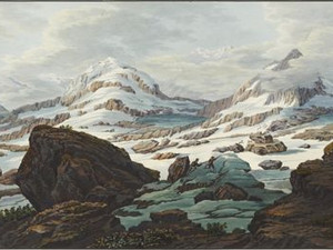
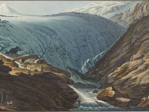
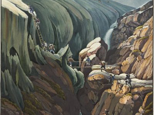
This view is one of the few in the Grosses Rheinwerk for which an accompanying text has actually been published. There we read:
"Mountainous regions have the peculiarity that they offer a new view from every changed vantage point. This is surprisingly evident in the picture of the Rheinwald glacier, which the artist gives on the second sheet. Here, in ancient times, the floods have eaten through a narrow valley between the gigantic rocks of the Vogelberg; wild and gruesome, as the ancients describe the entrance to the underworld. This valley, which winds for three hours from the village of Hinterrhein to the glacier, is jokingly called paradise, from which hell is not far away. Shattered granite mountains, ghastly waters in nocturnal forest shadows and the roar of falling streams form a scene that fills one with horror and is reminiscent of the dark Tartarus. Bergamasque shepherds drive their sheep into the Rheinwald valley for a few weeks in summer, and probably also serve as guides for foreigners; everything here is too steep and sloping for cattle. [...] When the Rheinwald glacier melts from time to time due to the burning heat of the sun, and individual parts of the rock on which it lies are exposed, broad, low elevations appear on the surface, like piles of hay lying side by side. According to the observations of the shepherds, the glaciers in the background are said to be increasing, and several otherwise frequented drifts have already disappeared under newly formed ice deposits."
Alois Schreiber, accompanying text to the Ouvrage representant en 70 à 80 feuilles les vues les plus pittoresques des Bords du Rhin [...], Schaffhausen/Laufen am Rheinfall ca. 1827-1843 (copy in the Museum zu Allerheiligen Schaffhausen, C5408), pp. 5-6
When artists or naturalists wanted to climb the mountains of the Rhine source region around 1800, they turned to Placidus a Spescha (1752-1833), a monk at the Disentis monastery. Called The Mountaineering Father, he felt most at home above the tree line and enthusiastically led strangers to the dizzying mountain peaks. Louis Bleuler also had him show him the most interesting places when he recorded the first views of his Rheinwerk in 1817/18.
Spescha vividly describes an ascent of the Rheinwaldhorn (3402 m.a.s.l.), which he undertook in 1791 with the "gentlemen doctors" Albrecht Rengger (1764-1835) from Bern, Jakob Ackermann (1765-1815) from Mainz and Wilhelm Friedrich Domeier (1763-1815) from Hanover:
"The gentlemen provided themselves with a guide from the Hinterrhein, who proved to be very experienced; for my safety, however, I took a mountain shepherd from the Alp Zaport with me, whose name was Antoni N.. We crossed the Thalglätscher in 2 hours and approached the gorge that lies southwest of the Guver-Horn. [...] The east-south side of the gorge was snowless, but when we reached the back of the gorge and the guide saw the depression of the Lenta glacier, he would rather lose his day's pay than continue with us, so he stayed behind. [...] Now we had to climb the snow-covered ridge of the mountain to be climbed towards the southwest. The shepherd went ahead, I followed and the others followed me. The ridge began to become steeper and steeper. The gentleman who followed me grabbed and held on to my robe, and the others to their skirts. The thing was difficult for me; so I approached the shepherd: he would also allow me to hold on to his skirt, etc., and he allowed it, because the back was sharp and slipping to the right would have been a danger of misfortune. [...] Renggar slipped away, and if I had not jumped after him, he would have gone down the long side of the snow like an arrow [...]. So I led him back to the others; but they were so frightened off by this accident that they couldn't take another step."
On the descent, the group also got into a dicey situation:
"We found the doctors sitting in the snow, just as we had planted them. They had not moved a single step from the place we had instructed them to, and the sweat they had broken out on the ascent had completely disappeared. And how happy were they when they saw us and led us out of the captivity of the snow? They were very content with the view they enjoyed, and none of them complained about where they were sitting. By the same path we descended to the gorge [...]. I went ahead and crossed a long but neither drowsy nor steep snow slope and was already below them when the gentlemen wanted to cross them. I watched them cross. Renggar slipped and came at me like an arrow; I caught him before he was off the snow, for he was a light gentleman. Now the same fate befell Mr. Ackermann, who was a fat and heavy man. I shot at him as a yoke hunter shoots at a fast-moving marmot. But I couldn't stop him until my legs had reached a stone bed. They got away unscathed and called me their savior. It was, in fact, lucky for me and them that I didn't have to force my way into the stone camp, because otherwise they wouldn't have made it without being significantly damaged."
Albert Lutz, Val Medel. Naturforscher und Landschaftsmaler erkunden den Rhein und die Berge am Lukmanier, 1700-1830, Curaglia 2024 (Neujahrsblatt der Gelehrten Gesellschaft in Zürich auf das Jahr 2024, 187. Stück); Ursula Scholian Izeti (ed.), Placidus Spescha, Genaue geographische Darstellung aller Rheinquellen [...], manuscript 1823, Zurich 2005, pp. 118-121
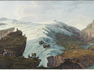
The accompanying text informs us about the impressions that the Hinterrheintal could arouse in visitors:
"Nature now changes as if by a stroke of magic, its horrors recede into the background, and with the vegetation the cheerful life of the people spreads, but a touch of melancholy still wafts over the whole landscape. The Wallisser mountain closes the view to the right, with the Zaporthorn behind it and the Muschelhorn to the left, while the Paradiesberg and the Vogelberg shimmer out between the two, always a little lower. You can see the Rhine, the son of the Alps, emerging from its ice palace."
Alois Schreiber, accompanying text to the Ouvrage representant en 70 à 80 feuilles les vues les plus pittoresques des Bords du Rhin [...], Schaffhausen/Laufen am Rheinfall ca. 1827-1843 (copy in the Museum zu Allerheiligen Schaffhausen, C5408), pp. 6-7
The Englishman William Tombleson describes Splügen after his visit in the 1830s:
"Five miles lower down is the village of Splügen, containing nearly 300 inhabitants, of the German race, professing the reformed religion. It is situated at the foot of the southern side of the mountain of the same name, which, with mount Bévers, produces several kinds of marble, some of which are equal in beauty to those of Carrara. For many years past these valuable quarries have been worked, and furnish many sculp- tors of eminence with ample materials for the exercise of their art. The village is situated, like the former, on the left bank of the river; and, from being at the junction of the two great roads from Coire to Italy, has an animated appearance, and is very prosperous. At the excellent inn, called the Bodenhaus, are seen specimens of minerals and plants, peculiar to the surrounding mountains. The foot of mount Splügen terminates on the opposite bank, where the south-eastern road to Italy branches off."
William Tombleson, Tombleson's Upper Rhine, London 1832, p. 172
Johann Gottfried Ebel was still able to recommend a visit to the waterfall, which was also known as the "upper Rhine Falls", in 1810. Today, the Hinterrhein is dammed up so high at this point that there is not much left of the waterfall.
"From Andeer to Splügen through the pass, the Roffeln 22 St. Bey the ruined Bärenburg Castle, once the key to one of the most important Alpine passes and a terrible nest of robbers, [...] is the entrance to the Roffeln, and here the Averserbach plunges terribly beautifully into the Rhine, which rages out of the Roffeln. At midday, when the sun is shining, descend into the gorge onto a peninsula that extends into the riverbed. The Roffeln, also known as the inner Viamala, is not as wild and scary as the outer Viamala."
Johann Gottfried Ebel, Anleitung, auf die nützlichste und genussvollste Art die Schweitz zu bereisen, vol. 2, Zurich 1810, p. 84
In William Tombelson's view of Andeer we read:
"Andeer is a village, situated in the valley of Schams, in a romantic country, at an elevation of 3,168 feet above the sea, between the two gorges of the Via-Mala and the Rofflen. [...] The inhabitants profess the reformed religion, and use the Romanic dialect, of which the curate of the place, Mathias Conrad, has published a grammar, and established its identity with the poesy of romance, by a collection of songs derived from the troubadours of the olden time. Every six years the reformed clergy of the Grisons hold a synod here. The village is handsomely built, and possesses a good inn at the sign of the White Cross."
William Tombleson, Tombleson's Upper Rhine, London 1832, p. 173
"We now come to Zillis, a village situated also in the valley of Schams, and containing 70 houses, with a population of nearly 400 protestants, whose language is the Romanic. Near this place are two bridges over the Rhine, and a picturesque fall, formed by the river, before it enters the redoubtable Via-Mala, whose pinnacled rocks are curiously interspersed with human habitations [...]."
Surprisingly, none of the guidebooks mention the main attraction of Zillis today, namely the wooden ceiling in the church with its Romanesque paintings. This was first described in 1808 and even renovated in 1820, but its scientific significance was only recognized by Johann Rudolf Rahn (1841-1912) in 1872. Instead, the legend of the former lord of the castle of La Tur near Zillis, who harassed his subjects and was punished for it, is mentioned several times.
William Tombleson, Tombleson's Upper Rhine, London 1832, p. 173; https://zillis-st-martin.ch/kirchendecke-st-martin-zillis/ [19.01.2026]
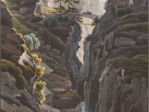
The German painter Johann Georg Primavesi vividly describes the threatening passage in the wild gorge:
"We are now on the actual Via mala, i.e. on that part of the path which is not without danger for travelers. To travel this route, specially equipped carts with low wheels are used. These are used to transport goods from and to Italy; however, this is done more on so-called pack horses, of which around 400 pass through here every week. Via mala is actually the name of the whole road that leads through the mountain gorge from Rongella to Ander. The part on which we are standing here [...] is called the inner, the one towards Ander the upper, and the one towards Rongella the lower via mala. In 1470, the inhabitants of Tusis undertook this enormous work. To position the bridges, tall fir trees had to be lowered by ropes over the rocky walls of the gorge, one end of which had to be fastened to one side and the other to the wall on the other side.
When we reach the bridge from above, we think we are being led into a dungeon; the three fir trees to the left of the bridge stand there like gatekeepers, as if to prevent us from crossing. No sooner have we gained a clearer view on the bridge than we have to descend again between rugged rock faces and wind our way out from under the large rock at the railing in the foreground. The rocky arch to the right of the bridge assumes that it was formed by a fall, and the somewhat regular formation of the rocks to the left of the bridge would appear to have been made by human hands if it were not beyond human strength in a narrow valley where almost no machinery can be used. Legend has it that this railing only came into being later, after a wagoner with wagon and horses had fallen down, just as good things are only caused by previous accidents everywhere."
Johann Georg Primavesi, Der Rheinlauf, von dessen verschiedenen Quellen bis zur Vereinigung des Vorder- und Hinter-Rheins bei Reichenau, Frankfurt a. M. 1818, p. 26
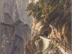
Johann Gottfried Ebel closely observed the expansion of the roads in Graubünden around 1818-20 and even visited the construction site:
"Just as it was necessary to build a wide road from Chur to Bellenz, a major difficulty arose here between Thusis and Schams. After investigations and assessments, the road contractor, State Councillor Poccobelli, decided not to lead the new road via Rongella, but straight through the gorge of the Verlohrnen Loch, and to venture the enormous work of blasting the rock over the abysses of the Rhine for almost 3/4 hours. Since the first bridge of the Viamala is only 312 feet higher than Thusis, and the new road could be led to it, the arduous ascent of 960 F. to Rongella and the descent of 618 F. to the first bridge was completely avoided, which would have lengthened the route considerably due to the many zigzag turns, not counting the costs. However, it took great boldness to think of paving a way through this gorge. During his stay in Thusis in the fall of 1819, the author ventured into this gorge over a foot-wide bridge, which was built high above the river on the left bank next to the terribly cracked and protruding rock faces, supported by wooden trestles as a staking out for the new road. No description can be given of the grassy wildness of this gorge in its original state, and although accustomed to the horror of mountain nature, the author was truly happy when he entered the green, friendly valley floor again. [...] During the blasting of this road in the Verlohrnen Loch some workers were unfortunate [= lost their lives], who had not moved far enough away after lighting the mines."
Johann Jacob Meyer et al, Die neuen Strassen durch den Kanton Graubündten, Zürich 1825, pp. 53-54
William Tombleson informs us:
"Tusis, to which we now come, is the most considerable place in the Domleschg valley. It is situated at the foot of the Heinzenberg, which the duke of Rohan declared to be the most interesting mountain of the Grisons and, perhaps, of the world. The inhabitants, amounting to upwards of 600, occupying 112 houses, are of the evangelical religion, and speak, generally, Romanic. Several fairs are held here, in the course of the year, and the tanning business is carried on to great advantage. In the vicinity is seen the first vine that was ever planted in these elevated parts of the Rhine borders. The burgh is also renowned for the excellence of its water, with which it is supplied from a spring, issuing from the foot of a rock, denominated Crapsteig, situated beyond the Nolla, a torrent, whose waters, sometimes perfectly black, gush from a long subterraneous passage connected with the Lüschersee, a small lake, imbedded on mount Tschappina, and in its course is mixed with a muddy decomposition of slate, of which the mountain is composed. This mud is often poured in such immense masses into the Rhine as to cause a reflux of its stream and make great ravages in the environs. We have in former pages mentioned that, at Reichenau, and a great distance farther on, the united waters of the river are totally blackened by this stream."
William Tombleson, Tombleson's Upper Rhine, London 1832, p. 176-177
"It is considered to be one of the most interesting parts of Switzerland. It contains twenty-two villages; some on the banks of the river, some reposing on the sides of superb mountains, and others spread, amid rich pastures, in the vale, the beauty of which is much heightened by the picturesque ruins of numerous castles, whose possessors figured conspicuously, at various and remote periods, in the eventful history of the country. The inhabitants of the valley amount to 3,000, and are about equally divided in language and religious profession; some speaking Romanic and others German. Their resources, like those of their neighbours, are principally derived from agriculture, the raising of cattle, and the carrying trade. Content with their lot, their wishes never seem to stray beyond the limits of their native soil; and as we shared, at times, their unaffected hospitality, and enjoyed the picture of their simple manners and steady patriotism, we were led to conclude that the most perfect remains of the primeval character of the Swiss are to be found in the peaceful valley of Domleschg."
William Tombleson, Tombleson's Upper Rhine, London 1832, p. 177-718
As with many remnants of the feudal era, the beginning of the 19th century was a turbulent time for Rhäzüns Castle:
"This castle, whose origins go far back into the past, is situated in an extremely picturesque location. From here you can enjoy a magnificent view of the Galanda and the glaciers of the Ringelberg on one side and the Domleschg valley and the ruins of Réalta on the other. There is a wonderful echo near the castle. [...] In the peace treaty of Vienna in 1805, the dominion of Räzuns was ceded to Bavaria; in the Treaty of Pressburg (1809) to Emperor Napoleon; and the canton of Graubünden finally received it through the deed signed at the Congress of Vienna on March 20, 1815. The transfer took place on January 19, 1821, and since then it has been sold to private individuals from the canton."
Johann Jakob Meyer, Johann Gottfried Ebel, Voyage pittoresque dans le canton des Grisons en Suisse, Zurich 1827, pp. 69-75
In his famous travel guide, which inspired Karl Baedeker among others, John Murray mentions a curious incident under the keyword Reichenau:
"Reichenau, which is a group of houses situated at the junction of the 2 Rhines. Its chief buildings are the Tollhouse (16 kr. paid for 2 horses); the inn zum Adler (Aigle); and the Château, a handsone whitewashed country-seat of the Planta family. At the end of the last century it was converted into a school by the burgo-master Tscharner. In 1793, a young man calling himself Chabot, arrived here on foot with a stick in his hand, and a bundle on his back. He presented a latter of introduction to M. Jost, the head master; in consequence of which he was appointed usher, and for 8 months gave lessons in French, mathematics, and history. This forlorn stranger was no other than Louis Philippe, now King of the French, then Duke de Chartres, who had been forced by the march of the French army to quit Bremgarten and seek concealment here in the performance of the humble duties of a schoolmaster, and in that capacity made himself equally beloved by masters and pupils. His secret was known only to M. Jost. During his residence here he must have heard the news of his father's death on the scaffold, and his mother's transportation to Madagascar."
John Murray, The Hand-Book for Travelers in Switzerland [...], Paris 1840, pp. 286-287
The French archaeologist and travel writer Désiré Raoul-Rochette (1789-1854) did not describe Chur very favorably in 1822. As a conservative who campaigned for the restoration of pre-revolutionary conditions in France, he was disturbed by the ambivalence between the Catholic episcopal see and what he saw as the overpowering Reformed municipality:
"The 8th-century cathedral, on the other hand, is rich in monuments and reminders of the Middle Ages. [...] Moreover, this church is almost the only refuge left to the nobility under the present constitution of Graubünden; and the great names can hardly reproduce under the protection of the sanctuary, where all privileges of birth in the state have been abolished. Almost all the old families, gradually reduced to poverty and thrown back into the lowest class of the people, have even lost the memory of their origin [...]. Near the church is the bishop's palace. This bishop, one of the oldest and once the richest in Christendom, is now one of the poorest; his income amounts at most to 10 or 12 thousand francs of our currency; he has no influence, he enjoys no authority in the government of his country - such is the present situation of a bishop who was for a long time the head of a feudal aristocracy known throughout Europe. [...] Some Catholic houses cluster like the unfortunate around their bishop in the upper part of the town; for the town of Chur is Protestant, and its bourgeoisie excludes Catholicism: a proof of intolerance which is no less prevalent, and seems to me more shocking among the Reformed than in the Roman Catholic Church. In all other areas, too, there is a strict dividing line between the Catholics and Protestants of Chur; for example, the cantonal school founded in this town ten years ago is only open to the Reformed, while the Catholics have their own school in the seminary."
Désiré Raoul-Rochette, Lettres sur la Suisse, Paris 1822, pp. 168-170; Daniela Vaj, Rochette, Désiré-Raoul, in: Historisches Lexikon der Schweiz (HLS), Version vom 02.12.2010, translated from Italian [16.02.2026]
The Pfäfers monastery is strategically located on a terrace above the paths to the Graubünden passes. It was founded as early as 730/750 and from the 14th century operated the much-visited baths in the Tamina Gorge, which became a significant economic factor. Johann Gottfried Ebel praised the view from the hills above the monastery:
"[...] in the uppermost rooms [of Pfäfers Monastery], and on the outermost height behind the monastery to the NE. 1/4 of an hour away, beautiful views of the wide valley on both sides of the Rhine from the Tardis Bridge. You can see Marschlins Castle, the entrance to the Prettigau; the wild Landquart as it emerges from the Kluss; the beautiful villages of Malans, Jenins, Maienfeld, at the foot of the Silvan or Augstenberg, the Falknis, Geirenspitz and Guscheralp [...]."
Johann Gottfried Ebel, Anleitung, auf die nützlichste und genussvollste Art die Schweitz zu bereisen, vol. 4, Zurich 1810, p. 27
Ebel continues:
"[...] the Fläscher-Berg, around which the Rhine winds its way northwards, the two-horned Scholl-Berg, at the foot of which lies the town and castle of Sargans, then the seven Kuhfirsten above Lake Wallenstadter, which is hidden from view. Underfoot lies Ragatz, the mouth of the Tamina into the Rhine, the ruins of Nydberg and Freudenberg castles."
Johann Gottfried Ebel, Anleitung, auf die nützlichste und genussvollste Art die Schweitz zu bereisen, vol. 4, Zurich 1810, p. 27
The German-Danish travel writer and publicist Friederike Brun (1765-1835) traveled through eastern and southern Switzerland in 1795. She describes the route in the Alpine Rhine Valley:
"On the right, in the depths of the Rhine valley between the Fläscher and Vadutzer mountains, the Rhine flows along in the morning glow and young August green; I am now traveling, but (in a spiral line along the belt of the Sargans mountains) in view of the path lying on the other side of the river, which I made to Chur, through Vorarlberg; there Balzers appears behind its green hill wall, and the melancholy ruins of Guttenberg appear solemnly. We are still traveling along the long Schollberg, which spreads out in crowns, dips into gorges and descends into lovely mountain terrain; Atzmoos and Räzüns lie on its broad side; we leave Werdenberg on the left, and on the right, Badutz with its beautiful mountain distances passes us on the other side of the Rhine [...]."
Friederike Brun, Tagebuch einer Reise durch die südliche, östliche und italienische Schweiz, Kopenhagen 1800, p. 112
Karl Baedeker gave tourists the following information about the Principality of Liechtenstein in 1844:
"On the right bank of the Rhine lies the German federal state, the two-square-mile sovereign Principality of Liechtenstein, which provides 55 men for the federal army. The Prince lives mostly in Vienna or on his other numerous mediatic possessions in Austria. The income of the small country amounts to around 20,000 guilders. The capital is Vaduz."
Karl Baedeker, Die Schweiz. Handbüchlein für Reisende [...], Koblenz 1844, pp. 401-402
"Werdenberg, very small town, not even provided with its own parish church, formerly capital of the county of the same name, in the canton of S. Gallen. Inn: bear. It lies at the north-eastern foot of the Kuhfirsten in a pleasant, fertile area near the Rhine. The old castle, ancestral home of the famous Counts of Werdenberg, still stands above the village. A beautiful view can be enjoyed from the nearby Grabserberg. A large fair and the road to Bünden enliven the place, and the inhabitants (reformed) live from agriculture, horse breeding and work for the cotton factories of S. Gallen and the canton of Appenzell. Way. In an hour and a half you can reach Wildhaus in Tockenburg on a stony path."
In fact, Werdenberg with its 90 inhabitants today is a small town, even the smallest in Switzerland. Its minor importance has meant that most of the village's medieval buildings have been preserved to this day.
Heinrich Heidegger, Handbuch für Reisende in der Schweiz, 4th edition, Zürich 1818, pp. 470-471; Lorenz Hollenstein, Werdenberg, in: Historisches Lexikon der Schweiz (HLS), Version vom 03.10.2013 [16.02.2026]
Friederike Brun tells us about her journey in 1795:
"From Feldkirch we immediately drove on a bridge over the foaming Ill, and soon afterwards a view opened up that united all the wild beauty of the high Alpine style. The greenish stream of rock pushes its way through a narrow side valley, and the opening on the other side is marked by two magnificent mountain profiles, which suddenly reminded me of the ascent into the valley of Grindelwald in the Bernese Oberland. To the left of the wedge-shaped mountain, a sublime mountain distance opens up over a veiled depth (I think the Rhine valley). Unfortunately, we lack a good map, and the inhabitants of the country answered every question with such reluctance and confusion that I can only ever guess the country."
Friederike Brun,Tagebuch einer Reise durch die südliche, östliche und italienische Schweiz, Kopenhagen 1800, pp. 36-37
Friederike Brun went on to recall her visit to Altstätten:
"We reached Altstetten, the main spot in the Rhine Valley and the destination of our journey today as darkness fell. This border town of Appenzell and the Rhine Valley lies gracefully on a green hillside in front of the Appenzell mountains; everything here testifies to prosperity, order and diligence, and we cheerfully entered the spacious wooden Schweizerhaus, where a clean meal refreshed us after such a long privation. S***s and Carl (for the boy is inseparably attached to the noble S***s, whose lofty image may be indelibly imprinted on his mind!) had come a little way off in these charming green meanderings, and only arrived late."
She mentions her traveling companion, whose identity she only wanted to reveal to selected persons. However, we can assume that "S***s" was Johann Gaudenz von Salis (Seewis) (1762-1834). The scion of an old noble family from Graubünden was enthusiastic about the ideas of the French Revolution and was an important poet.
Friederike Brun, Tagebuch einer Reise durch die südliche, östliche und italienische Schweiz, Kopenhagen 1800, pp. 122-123; Andreas Fankhauser, Salis, Johann Gaudenz von (Seewis), in: Historisches Lexikon der Schweiz (HLS), Version vom 12.01.2012 [16.02.2026]
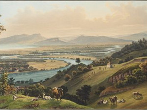
The winding watercourse in this view is now known as the "Old Rhine". It is the remnant of the former mouth of the Rhine into Lake Constance, which repeatedly overflowed its banks and became a disaster for people.
"In order to remedy the frequently recurring plight and torment of the Rhine, which for centuries had afflicted either the right or the left side of the valley, Austria and Switzerland agreed in December 1892, after decades of negotiations, to carry out the regulation of the course of the river from the mouth of the Ill to Lake Constance jointly and at equal cost. The construction costs were estimated at CHF 16,560,000. Following the approval of this contract by all the relevant authorities, construction work began without delay in 1895 and the first section, the Fussacher Durchstich, was opened in May 1900. The resulting shortening of the course of the river from over 12 km to around 5 km [...] resulted in a reduction in flood levels that was noticeable as far as Oberriet. The beneficial effect of the new diversion of the Rhine into Lake Constance was particularly evident during the extraordinary flood of June 1910; without it, the lower Rhine valley would probably have been the victim of a serious catastrophe at the time."
C. B., nternationale Rheinregulierung. (Im St. Gallischen Oberrheintal), in: Schweizerische Bauzeitung 79/80 (1922), issue 15, pp. 198-199
"RHEINECK, small town in the canton of St. Gallen, 1 st. from the confluence of the Rhine with Lake Constance, in the Rheinthal countryside. Inns: Krone, and Rebstock. [...] It enjoys a beautiful location in the middle of the Lower Rhine Valley. A pleasant walk from here to the Buch-Berg (1 hour), where there is a magnificent view from the so-called stone table. [...] The walks from Rheineck down to Thal and Staade, and from Rheineck up to St. Margaretha, Bernang, Rebstein, Marbach and Altstädten along the magnificent mountain terrain are among the most charming in Switzerland. Vineyards, fruit trees, meadows and fields cover the small valleys and varied hills that rise up to the Appenzell mountains, and a number of villages, hamlets, castles and beautiful country houses enliven the whole. [...] Rheineck has some beautiful buildings; a lot of timber and transit trade, bleaching, dyeing and linen wall, cotton, neck and hankie factories; skilled craftsmen. Mr. Kuster (former finance minister of the Helvetic Republic) lives here [...] and Mr. Joh. Rud. Steinmüller (pastor), who owns a natural history cabinet and is renowned as a naturalist and writer. [...] The best red Rheinthaler wine, which is the finest in the whole of German Switzerland, also grows in this district on the Buchberg, and the best white Rheinthaler wine grows near Bernang."
Johann Gottfried Ebel, Anleitung, auf die nützlichste und genussvollste Art die Schweitz zu bereisen, vol. 4, Zurich 1810, pp. 95-97

In this view, we can clearly see the two traffic routes along the shore of Lake Constance. On the one hand, there is the road, which is only used by pedestrians and horse riders. It will be developed into an artificial road from 1838. However, we can already see the rows of trees alongside it. These were chestnut trees in Thurgau and poplars in the canton of St. Gallen. Transporting goods by water, on the other hand, was much more efficient and suitable: hundreds of tons of grain and salt were transported to Switzerland this way every year; cloth, wine, cheese and lard left again.
Inventory of historic transport routes in Switzerland (IVS) SG 36 (PDF) [02.02.2026]; Inventory of historic transport routes in Switzerland (IVS) TG 40 (PDF) [02.02.2026]

"ARBON, a small town on Lake Constance, Cant. Thurgau, Arbor felix at the time of the Romans. Old walls can be seen in the lake at very low water levels. The location is very beautiful; a veritable forest of fruit trees surrounds it. Citrus factories here. The tower of the castle shows the type of construction from the time of the Merovingian kings."
By "Zitz", Ebel means a "colorful printed cotton fabric in linen weave with a high-gloss effect". Arbon therefore also played its part in the textile industry in eastern Switzerland at the time.
Johann Gottfried Ebel, Anleitung, auf die nützlichste und genussvollste Art die Schweitz zu bereisen, Zürich 1810, vol. 2, p. 128; eronika Feller-Vest, Lütschg, Jakob, in: Historisches Lexikon der Schweiz (HLS), Version vom 05.04.2007 [16.02.2026]

Constance was remembered by travelers in the 19th century above all for its importance as a council city at the beginning of the 15th century. Ebel also mentions the contemporary art in the city:
"Magnificent views from the tower of the cathedral, at the harbor, on the dam, on the bridge, on the island of Meinau 1 St., on the island of Reichenau in Lake Zell [...], in Hardt 12 St. from the city, and during walks on the Boden-See. Beautiful works of old Gothic sculpture in wood and stone are in the Dohmkirche. At HH. Niklas Matt and Felix Späth etched drawings of many areas of Lake Constance are sold. The excellent landscape and portrait painter Mr. Biedermann (a native of Winterthur) lived here (now in Frankfurt am Main) for several years. His Schweitzer landscapes both in oil and in colored wash are among the most splendid works of this kind [...]."
Johann Gottfried Ebel, Anleitung, auf die nützlichste und genussvollste Art die Schweitz zu bereisen, vol. 3, Zurich 1810, p. 249

Ebel warmly recommends a visit to the island of Mainau, which today is famous above all for its flower gardens:
"MEINAU (the island), in the northern bay of Lake Constance, connected to the western shore by a narrow bridge of 630 steps, from where you can walk to the town of Constance in 12 hours. Travelers who take a carriage from Ueberlingen or Mörsburg to Meinau will find horses here with which they can travel to Constance. The island, a hill 4 meters in circumference, was the property of the Order of St. John; the Commander's castle stands at the highest point; all travelers are welcomed here with great kindness and courtesy. Vegetable gardens and orchards, vineyards, cornfields and meadows enliven this magnificent island, which is inhabited by 50-60 people. The location and views from this island are magnificent, and it therefore deserves a visit from every nature lover. The most beautiful viewpoints are in the upper rooms of the castle and in the garden. Also worth seeing here are the wine cellars, in which there are 100 barrels, each of which can hold 5000 bottles, and a single one 184,320 bottles."
Johann Gottfried Ebel, Anleitung, auf die nützlichste und genussvollste Art die Schweitz zu bereisen, vol. 3, Zurich 1810, pp. 455-456

"The island is 14 hours long, 2 hourswide, and contains 1600 inhabitants in the three villages of St. Johann, Oberzell and Niederzell. At the eastern end are the ruins of Schopflen Castle. In the fall, the lake recedes so much that you can walk from Schopflen to Wollmattingen on dry land. The island is almost entirely covered with vineyards; the best wine on the entire German shore of Lake Constance is the Schleitheimer on the island of Reichenau. There is a cross on the highest hill of the island, from where there is a magnificent view. The abbey fell into disrepair, was incorporated into the Cathedral Chapter of Constance in 1538 and, together with the island and the Swabian shores of Lake Zell, has belonged to the Grand Duke of Baden since 1802."
Johann Gottfried Ebel, Anleitung, auf die nützlichste und genussvollste Art die Schweitz zu bereisen, vol. 4, Zurich 1810, pp. 523-524

In Karl Baedeker's travel guide - not yet known by its later abbreviation - travelers could learn the following about Stein am Rhein:
"Stein (inns Schwan, Krone), an old picturesque town belonging to Schaffhausen on the right bank of the Rhine, connected to the left bank by a bridge. Some of the houses, namely the red ox and the white eagle next to the department store, have preserved their not entirely bad fresco paintings, which cover the entire front with objects of various kinds, intact. The old Hohenklingen Castle, on a hill, belongs to the town of Stein and is inhabited by a tenant."
Karl Baedeker, Die Schweiz. Handbüchlein für Reisende [...], Koblenz 1844, p. 50
Heinrich Heidegger described the small town of Diessenhofen in 1818:
"Diessenhofen, small town of 204 houses and about 1200 inhabitants in the canton of Thurgau. Inn: the sun. This small town lies in a fertile, hilly area on the Rhine, over which a covered bridge leads, it is the northernmost in Switzerland [...]. The streets are quite wide and adorned with a few attractive houses. The inhabitants, Reformed and Catholics, worship in the same church and live mainly from agriculture; the transit from Lake Constance to Constance provides some income. The beautiful Dominican convent of S. Katharinenthal is a quarter of an hour from the village."
Heinrich Heidegger, Handbuch für Reisende in der Schweiz, 4th edition, Zurich 1818, p. 177
Schaffhausen was remarkable above all for its location as a border town and its proximity to the Rhine Falls - in any case, Karl Baedeker found in 1844:
"Schaffhausen, the capital of the canton of the same name, with 6083 mostly reformed inhabitants, has preserved the external forms of medieval architecture better than any other town in Switzerland, because no house has been destroyed by fire here for centuries. The oriels, the peculiar roofs, the curtain wall which completely surrounds the town from the land side, the stately old castle of Unnoth, the ancient gates give Schaffhausen a very picturesque appearance, especially from the village of Feuerthalen opposite. Otherwise, of course, the town offers little of note; it could hardly be regarded as anything other than the gateway to Switzerland, as the gateway station, as the Austrians put it, and only passers-by would be seen within its walls if it were not for the Rhine Falls, which captivate everyone."
The publisher of this series of views, Johann Ludwig (Louis) Bleuler, founded his own publishing house in 1824 in the house "zur goldenen Lilie" in Schaffhausen, which he moved in 1832 to Laufen Castle on the Rhine Falls, which he now leased. He ran Bleuler's painting school there until his death in 1850 and coordinated the production of the numerous views.
Karl Baedeker, Die Schweiz. Handbüchlein für Reisende [...], Koblenz 1844, pp. 44-45; Robert Pfaff, Die Bleuler Malschule auf Schloss Laufen am Rheinfall, Neuhausen am Rheinfall 1985, p. 36; Werner Rutishauser, Ludwig Bleuler, in: SIKART Lexikon zur Kunst in der Schweiz, 2015 (first published 1998) [16.02.2026]
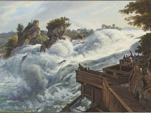
People have always perceived the Rhine Falls not only as a traffic obstacle, but also as a natural wonder that was worth traveling from far away to see. The Schaffhausen chronicler Johann Jakob Rüeger (1548-1606) described this around 1600 - and the fascination for the thundering masses of water has by no means diminished since then.
"[The Rhine Falls] is the quite large loufen und fall of the Rhine, of which one speaks as a wonder in all lands, and many people com from far away to see it. Then the Rhine at this place has a great, gushing, marvelous high fall; no ship can come down there, otherwise it would fall to pieces. Nor may any fish in the water reach the height of this rock, even if they had long crooked teeth, like the sea animal called Rosmarus or Mors, says Münsterus. The Rhine, after it has come a little way from the upper rapids into its old quiet and narrow course, and this as far as a thousand paces, continues on through several ravines and fissures to the end of the same; Then he lifts over the same staggered rough rock eight or five fathoms deep, falling down with such force and forcefulness, dosing, swirling and clashing with the rocks that stand upright in it. Some of them were so devastated by the river's forceful fall that, however strong and hard they stood, they had to give way to the water and were thrown down into the depths [...]."
Historisch-Antiquarischer Verein des Kantons Schaffhausen (ed.), Johann Jakob Rüeger, Chronik der Stadt und Landschaft Schaffhausen, vol. 1, Schaffhausen 1884, p. 37
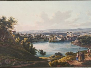
"Below the Cataract, the Rhine winds in multiple bends through a beautiful, partly fertile region. First it meanders towards the south, then towards the west and north, finally towards the south again; then two narrow tongues of earth bend into the river, in the middle of which lies an island. One of these tongues of earth bears the small town of Rheinau, which belongs to the canton of Zurich, but on the island, to which a stone bridge leads, stands the old Benedictine abbey of the same name. The other tongue of land belongs to the Baden region, and so Germany and Switzerland interlock here, as it were. The small town (with only 600 inhabitants and around 90 houses) probably owes its origins to the Romans. The Benedictine monastery was founded in 778, and the marble tomb of the founder, an Alemannic prince Wolfhart, can still be seen in the monastery church."
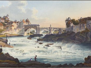
In the case of Laufenburg, too, it is Johann Wilhelm Appell who provides the most vivid description of the town's main attraction - namely the rapids, which the shipping traffic only overcame with great effort on the part of the boatmen's guild:
"More than doubled in size by the influence of the Aar, the river rushes past the small Baden town of Waldshut, which, situated on the southern drop of the Black Forest, was once the first of the four old forest towns. At the ancient Aargau town of Laufenburg (with 650 inhabitants and 158 houses), which also belonged to the forest towns, it then shoots down again between rocks and over rocks, forming a 20-foot drop. This drop is also called the "Laufen". Experienced skippers know how to lower their boats over the waterfall along the shore on ropes without causing any damage, but usually unloaded. The goods are also unloaded above the fall and loaded again below it. This is a very lucrative salmon fishery. The ruins of the castle of the mighty Counts of Habsburg-Lauffenburg lie on a hill near the little town. A 306-foot-long bridge leads, just where the fall begins, to the small Baden town of Kleinlaufenburg on the other side, with which the larger Laufenburg (also called Großlaufenburg) on the Swiss side belonged together until 1802."
"Rheinfelden, small town of 252 houses and 1436 inhabitants, on the left bank of the Rhine, in the Aargau valley of Frick. Inns: Schiff, three kings. This border town lies in a fertile area on the road from Basel to Schaffhausen, Zurich and Aarau, which, like the shipping industry, enlivens it. For twenty batzen you can hire a very small boat with a skipper to Basel. The trip from Nieder-Mumpf to Rheinfelden is only advisable with experienced helmsmen, and for the unaccustomed it is terrifying. The first bridge leads to an island in the Rhine, the second to the German bank, where the Rhine foams most wildly, over the dangerous whirlpool Höllenhaken. On the island in the river stand the ruins of the castle, called Stein von Rheinfelden, of which more and more is being pulled down. The town has well-equipped schools, a canon monastery, a hospital and nearby an flour mill, tobacco stamping mill, a paper mill and a quarry. It suffered greatly in the Swedish War; its fortifications were razed by the French in 1744."
Robert Glutz-Blotzheim, Handbuch für Reisende in der Schweiz, Zurich 1823, p. 370
In the mid-19th century, Basel was regarded as an ancient city whose inhabitants lived crammed together within the medieval city walls and were ravaged by epidemics every few years. Basel got rid of its walls and developed new residential areas in the surrounding countryside only later than other cities. It is against this background that we must read Appell's description.
"Basel has retained that serious and rigid Protestant physiognomy [...] to this day, and there are certainly few cities where the old bourgeois and old-faith spirit still expresses itself as decisively as here. It cannot be denied that the people of Basel are not very popular abroad or in Switzerland. They are accused of stubbornly clinging to the old and outdated, exaggerated thriftiness, an unsociable and, above all, a dull pietistic spirit [...]. If the people of Basel generally have a certain attachment to the traditional, if the city, through whose gates the great trade routes of southern and eastern Germany to France, western France and Germany to Italy pass, has perhaps resisted the transformations of the new age for the longest time, it has also preserved old virtues that distinguish it from many other cities. A certain bourgeois solidity and the neatly ordered prosperity that we encounter everywhere in the houses of Basel's merchants instill respect in the foreigner. Beautiful traits of the people of Basel are their attachment to their home town, their public spirit, which has given rise to many charitable and useful donations, as well as their sense of science and art, which is reflected in the sometimes rich and excellent collections."
The medieval old town with its many churches and city palaces was rarely recognized and depicted in its picturesque value, which amazes us today. Louis Bleuler also wrote in a letter to his wife Antoinette about the draughtsman Egidius Federle, who had recorded this view:
"I would like to speak to him and order a well-chosen view of the city of Basel to accompany our Rhine work [the Kleine Rheinwerk]. This, according to Federle, is simply a view of the Basel area."
In fact, a view of the city center of Grossbasel by the Mittlere Brücke appeared in the Kleines Rheinwerk around 1850.
Susanne Bieri, "De Bâle aux sources du Rhin". Zu einem Forschungsprojekt der Graphischen Sammlung, in: 86. Jahresbericht der Schweizerischen Landesbibliothek 1999, p. 37-39; Ursula Isler-Hungebühler, Die Maler vom Schloss Laufen. Kulturgeschichtliche Studie, Zürich 1953; Albert Lutz, Val Medel. Naturforscher und Landschaftsmaler erkunden den Rhein und die Berge am Lukmanier, 1700–1830, Curaglia 2024 (Neujahrsblatt der Gelehrten Gesellschaft in Zürich auf das Jahr 2024, 187. Stück); Robert Pfaff, Die Bleuler Malschule auf Schloss Laufen am Rheinfall, Neuhausen am Rheinfall 1985; Werner Rutishauser, Die Bleuler und der Rhein. Von majestätischen Gletschern, tosenden Katarakten und schauerlichen Burgen (Ausst.-Kat. Museum zu Allerheiligen Schaffhausen 1997), Schaffhausen 1997