Grand Hotels and Mountain Inns: The Origins of the Swiss Hotel Industry

Grand Hotels and Mountain Inns: The Origins of the Swiss Hotel Industry
Bilder
zbz-990110754400205508
Titel
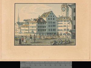
Zurich, Hotel Schwert
Text

"Of the three bridges connecting the two parts of the city, only one is accessible to carriages and also serves as a marketplace. From here, one has a magnificent view of the lake, the Limmat River, the city center, and the distant peaks of the High Alps. At the end of this bridge stands the “Schwert” inn, which would be the first of its kind in Switzerland for that reason alone, were it not also the first in other respects."

It wasn’t just the French travel writer and archaeologist Désiré-Raoul Rochette (1790–1854) who was enthusiastic about Zurich’s Hotel Schwert: In the 18th century, the hotel on Weinplatz was the quintessential meeting place for Europe’s nobility and celebrities. The list of illustrious guests is long and bears witness to the history of the city’s oldest inn, which dates back to the 11th century. For example, Leopold Mozart (1719–1787) stayed at the Schwert with his two children, Wolfgang (1756–1791) and Anna (1751–1829), and two years later, the Venetian seducer Giacomo Casanova (1725–1798) at the Schwert before setting off toward Einsiedeln Abbey. However, the numerous changes brought about by the turn of the 19th century—such as the steadily rising number of travelers to Switzerland, new travel routes and modes of transportation, and new political orders—proved challenging for this traditional establishment. New hotels in Zurich seized the opportunity and tailored their services to the needs of 19th-century travelers, causing the Schwert to gradually lose its prominence.

Ort auf moderner Karte
GEOMETRYCOLLECTION (POINT (8.543765 47.371849), LINESTRING (8.543765 47.371849, 8.541958 47.371639))
Camera Settings (3D)
{"landscape":{"image.scale":72,"camera.fov":48,"viewpoint":{"bounds":[[8.546243161174061,46.916457403721495],[9.643788335175856,47.85497656586227]],"bearing":-104.59558316659798,"pitch":78.9989019996317,"zoom":17.397464149039035,"center":{"lng":8.54370577811153,"lat":47.37176772337142},"cam":{"center":{"lng":10.221320602657471,"lat":47.48397608999511},"zoom":7.306097661933291,"bearing":0},"cameraToCenterDistance":1062.3753940566944,"cameraPosition":{"lngLat":{"lng":8.547815860431001,"lat":47.37249253836475},"altitude":478.8673895654082},"cameraTargetElevation":416.69165588576044}},"portrait":{"viewpoint":{"bounds":[[8.546280177031377,47.17749713776914],[8.994244805095207,47.57390139647987]],"bearing":-104.59558316643326,"pitch":78.99776591293558,"zoom":17.330723010450452,"center":{"lng":8.543705778109796,"lat":47.371767723371335},"cameraToCenterDistance":1014.3517734010212,"cameraPosition":{"lngLat":{"lng":8.547815860429296,"lat":47.37249253836467},"altitude":478.8739710643663},"cameraTargetElevation":416.69165588576044},"image.scale":60},"square":{"image.scale":72,"viewpoint":{"bounds":[[8.321497343404928,47.27668473396338],[8.545840451772335,47.506214911624795]],"bearing":-95.79558316643323,"pitch":76.49776591293558,"zoom":17.556032654871604,"center":{"lng":8.543320210470142,"lat":47.37182676169124},"cam":{"center":{"lng":8.805374635962067,"lat":47.42333027811287},"zoom":8.905462167599485,"bearing":0},"cameraToCenterDistance":1014.3517734010212,"cameraPosition":{"lngLat":{"lng":8.546900602302287,"lat":47.37207287211601},"altitude":481.76622017505485},"cameraTargetElevation":416.69165588576044}},"null":{"viewpoint":{"bounds":[[8.543976097529452,47.227686432351305],[8.875856230154,47.52137423722692]],"bearing":-104.59558316659798,"pitch":78.9989019996317,"zoom":17.761429093704265,"center":{"lng":8.542066071253004,"lat":47.37154544415702},"cam":{"center":{"lng":8.84431429231384,"lat":47.38622254641072},"zoom":10.373110079856586,"bearing":0},"cameraToCenterDistance":1014.3517734010212,"cameraPosition":{"lngLat":{"lng":8.54511534731273,"lat":47.372083188676584},"altitude":462.82011768949667},"cameraTargetElevation":416.69165588576044}}}
Quellen

Désiré Raoul-Rochette, Lettres sur la Suisse, Paris 1820, p. 266; Schweizerischer Ingenieur- und Architecten-Verein, Zürich's Gebäude und Sehenswürdigkeiten, Zurich 1877, p. 30; Joseph Jung, Das Laboratorium des Fortschritts. Die Schweiz im 19. Jahrhundert, Basel 2019, pp. 56–57
 

Bilder
zbz-990110754170205508
Titel
Zurich, Hotel Storchen
Text

Directly across from the Hotel Schwert is the Hotel Storchen, which overlooks Weinplatz and the Limmat River. This inn is also one of the oldest in Switzerland: the building has borne this name since 1357, and there is documented evidence of the “Haus zum Storchen” operating as an inn since the 15th century. Alongside the Hotel Schwert, the Hotel Storchen was one of the most popular destinations in Zurich at the time: distinguished guests, envoys, and statesmen also stayed here. The hotel is mentioned less frequently than the Schwert in travel guides from around 1800—possibly because the inn was particularly popular with traveling merchants.

Ort auf moderner Karte
GEOMETRYCOLLECTION (POINT (8.542439 47.371927), LINESTRING (8.542439 47.371927, 8.541602 47.371284))
Camera Settings (3D)
{"landscape":{"viewpoint":{"bounds":[[8.543048173208888,47.37307939199749],[8.574575108296727,47.39014860473242]],"bearing":-146.39870257495775,"pitch":85.02396229951937,"zoom":17.886595062051875,"center":{"lng":8.541971050011625,"lat":47.37159033084194},"cam":{"center":{"lng":8.581446543019808,"lat":47.3833175913459},"zoom":13.127085210214316,"bearing":0},"cameraToCenterDistance":1176.262045899493,"cameraPosition":{"lngLat":{"lng":8.543852715382627,"lat":47.37350823869019},"altitude":438.985176788252},"cameraTargetElevation":416.69165588576044},"image.scale":50},"portrait":{"viewpoint":{"bounds":[[8.543204062186646,47.372933437246274],[8.581538134676038,47.39330274635083]],"bearing":-141.59870257488672,"pitch":84.52061465929985,"zoom":17.88658697866912,"center":{"lng":8.54197105001208,"lat":47.371590330841826},"cameraToCenterDistance":1176.262045899493,"cameraPosition":{"lngLat":{"lng":8.54408140620626,"lat":47.37339344233706},"altitude":441.2338381224052},"cameraTargetElevation":416.69165588576044},"image.scale":60},"square":{"image.scale":61,"viewpoint":{"bounds":[[8.54320795900611,47.372806215434025],[8.56593560220071,47.384883823904545]],"bearing":-141.59870257488672,"pitch":84.52061465929985,"zoom":18.640766175552837,"center":{"lng":8.542476926305199,"lat":47.37200991187666},"cam":{"center":{"lng":8.581397851259368,"lat":47.38086368376534},"zoom":12.88199853598,"bearing":0},"cameraToCenterDistance":1176.262045899493,"cameraPosition":{"lngLat":{"lng":8.543728121889586,"lat":47.37307894605189},"altitude":431.2421975565001},"cameraTargetElevation":416.69165588576044}},"null":{"viewpoint":{"bounds":[[8.54141186176713,47.37080998178624],[8.610504343540384,47.41453136508974]],"bearing":27.201297424120416,"pitch":78.49999999999999,"zoom":18.8843675455423,"center":{"lng":8.542273366069253,"lat":47.371786961032285},"cam":{"center":{"lng":8.601841690991762,"lat":47.39493611574056},"zoom":12.71786795912225,"bearing":0},"cameraToCenterDistance":1347.8225995402577,"cameraPosition":{"lngLat":{"lng":8.541396112211032,"lat":47.37063099980287},"altitude":446.094315619804},"cameraTargetElevation":416.69165588576044}}}
Quellen

Cäsar Schmidt,Zürich und seine Umgebungen, Zurich 1876, p. 6; Hans Hoffmann and Paul Kläui, Die Kunstdenkmäler des Kantons Zürich, Volume V, Part 2: Die Stadt Zürich, in: Die Kunstdenkmäler der Schweiz, edited by the Gesellschaft für Schweizerische Kunstgeschichte, Basel 1949, pp. 234–235

Bilder
zbz-990110804300205508
Titel
Zurich, Hotel Baur en Ville
Text

"There is a new hotel in Zurich, the Hotel Baur, which is exceptional in every respect." In his "Handbook for Travelers" from 1839, John Murray (1737–1793) highlights—right in the book’s colophon—the Hotel Baur en Ville, which opened in 1838 in the center of Zurich. 

The modern hotel was built on behalf of the Vorarlberg hotelier Johannes Baur (1795–1865); the plans for the Neoclassical building were drawn up by master builder and architect Daniel Pfister (1808–1847). Baur also ran two taverns in Zurich, so he was familiar with the city’s hospitality industry—and had a keen sense of the spirit of the times. He chose a very strategic location for his Hotel Baur en Ville: The building still stands today on Paradeplatz; at the time, the hotel was located directly across from the central courtyard of the post office. This spot was essentially a station for carriages: The stagecoach drivers of the time would drop off their passengers in the central courtyard and change horses for the next leg of the journey.  

The expansion of transportation infrastructure was one of the key factors that shaped tourism in the first half of the 19th century. Access to a road network or waterways was a decisive factor in whether travelers chose to visit a destination or skipped it in favor of more accessible ones. The shrewd hotelier Baur built his own stables and parking spaces for carriages next to his hotel, so that travelers could even be driven right up to the hotel’s gates.

Ort auf moderner Karte
GEOMETRYCOLLECTION (POINT (8.53855 47.369397), LINESTRING (8.53855 47.369397, 8.539419 47.369873))
Camera Settings (3D)
{"landscape":{"viewpoint":{"bounds":[[8.47706707366899,47.33631102500951],[8.537661794227233,47.36867281965294]],"bearing":45.99642466812929,"pitch":85.18746324310818,"zoom":17.391259751839154,"center":{"lng":8.540527925812967,"lat":47.37068711996349},"cam":{"center":{"lng":10.475364806561203,"lat":47.517925097900275},"zoom":6.523551224569174,"bearing":0},"cameraToCenterDistance":1363.9064014440792,"cameraPosition":{"lngLat":{"lng":8.536529395632414,"lat":47.36807162936384},"altitude":452.25303828136526},"cameraTargetElevation":417.0075871230109}},"portrait":{"viewpoint":{"bounds":[[8.477144857911924,47.33635262401398],[8.537660608789167,47.36867219471543]],"bearing":45.996424667833026,"pitch":85.19355876597139,"zoom":17.391272665835192,"center":{"lng":8.540527925815013,"lat":47.370687119964174},"cameraToCenterDistance":1363.9064014440792,"cameraPosition":{"lngLat":{"lng":8.53652939563446,"lat":47.36807162936449},"altitude":452.20818639912784},"cameraTargetElevation":417.0075871230109}},"square":{"image.scale":72,"viewpoint":{"bounds":[[8.476107488938055,47.323782745550744],[8.538226604554154,47.36844484640113]],"bearing":37.196424667833064,"pitch":84.69355876597139,"zoom":17.391272665835192,"center":{"lng":8.540527925815809,"lat":47.37068711996423},"cam":{"center":{"lng":8.507167046746105,"lat":47.347417764683854},"zoom":13.518383424834303,"bearing":0},"cameraToCenterDistance":1363.9064014440792,"cameraPosition":{"lngLat":{"lng":8.537169862186403,"lat":47.367690423750815},"altitude":455.86002119828083},"cameraTargetElevation":417.0075871230109}},"null":{"viewpoint":{"bounds":[[8.13885201451123,47.17034427229308],[8.537691483170619,47.38775253804059]],"bearing":54.48051298981978,"pitch":81.50558818690104,"zoom":18.76146584914372,"center":{"lng":8.538755232936637,"lat":47.369476060139306},"cam":{"center":{"lng":8.478001222554923,"lat":47.29093926460112},"zoom":10.339573446827272,"bearing":0},"cameraToCenterDistance":1363.9064014440792,"cameraPosition":{"lngLat":{"lng":8.537018058837077,"lat":47.36863623710505},"altitude":440.69754738075744},"cameraTargetElevation":416.69165588576044}}}
Quellen

John Murray, Handbook for Travellers in Switzerland, and the Alps of Savoy and Piedmont, London 1839, Imprint; Joseph Jung, Das Laboratorium des Fortschritts. Die Schweiz im 19. Jahrhundert, Basel 2019, pp. 57–59

Bilder
zbz-990100487720205508
Titel
Zurich, Hotel Baur au Lac
Text

In the first edition of Karl Baedeker’s travel guide, published in 1844, the Hotel Baur en Ville was criticized for having "no view". The hotelier Johannes Baur (1795–1865) also recognized that an impressive panoramic view was another key factor in the success of a hotel at that time. So in 1844, he opened his second hotel on the shores of Lake Zurich and named it "Baur au Lac" to distinguish it from his city hotel. Accordingly, the 1863 edition of Baedeker praised the lakeside hotel: "Hôtel et Pension Baur au Lac […], on the lake, charming location, well-maintained, with a garden, bathhouse, and reading room".

Thanks to its lakeside location, the Hotel Baur au Lac was also situated in the immediate vicinity of the Bauschänzli, where the first steamship on Lake Zurich—the Minerva, built in England—began docking in 1835.

Ort auf moderner Karte
GEOMETRYCOLLECTION (POINT (8.540443 47.367129), LINESTRING (8.540443 47.367129, 8.539478 47.366831))
Camera Settings (3D)
{"landscape":{"viewpoint":{"bounds":[[8.400063058451764,47.29250658623661],[8.542315277043826,47.37077611972768]],"bearing":-134.46787167686693,"pitch":78.32972151965905,"zoom":18.145947205816185,"center":{"lng":8.540283930525561,"lat":47.36707639470393},"cam":{"center":{"lng":8.543237518703393,"lat":47.337081243316476},"zoom":11.456668877207923,"bearing":0},"cameraToCenterDistance":1323.1607699543977,"cameraPosition":{"lngLat":{"lng":8.54252564397109,"lat":47.368566740003246},"altitude":465.8714851107892},"cameraTargetElevation":417.0075871230109},"image.scale":78},"portrait":{"image.scale":78,"viewpoint":{"bounds":[[8.400063058338816,47.2925065861474],[8.542315277043087,47.370776119709774]],"bearing":-134.46787167686693,"pitch":78.32972151965905,"zoom":18.145947205816185,"center":{"lng":8.540283930524879,"lat":47.367076394704895},"cameraToCenterDistance":1323.1607699543977,"cameraPosition":{"lngLat":{"lng":8.542525643970407,"lat":47.36856674000421},"altitude":465.87148511078834},"cameraTargetElevation":417.0075871230109}},"square":{"image.scale":75,"viewpoint":{"bounds":[[8.399928570179327,47.292434816332275],[8.542315293286805,47.37077864161617]],"bearing":-134.46787167686693,"pitch":78.3327791124071,"zoom":18.145963105789278,"center":{"lng":8.54028393052647,"lat":47.36707639470407},"cam":{"center":{"lng":8.543238622221821,"lat":47.33705179623158},"zoom":11.455301096058864,"bearing":0},"cameraToCenterDistance":1323.1607699543977,"cameraPosition":{"lngLat":{"lng":8.542525643971999,"lat":47.368566740003416},"altitude":465.8583219327357},"cameraTargetElevation":417.0075871230109}}}
Quellen

Karl Baedeker, Die Schweiz. Handbüchlein für Reisende, Coblence 1844, p. 56; Karl Baedeker, Die Schweiz, nebst den angrenzenden Theilen von Piemont, der Lombardei und Tirol. Handbuch für Reisende, Coblence 1863, p. 39; Peter Ziegler, "Zürichsee", in: Historisches Lexikon der Schweiz (HLS), version dated June 10, 2015 [accessed October 8, 2025].

Bilder
zbz-990100554810205508
Titel
Uetliberg, Uto-Kulm Hotel and Restaurant
Text

"No place in the Zurich area—neither the Weid [...], nor the now much-visited Schlössle on the Zürichberg [...], deserves the attention of every traveler more than the Uetliberg to the west, the foothills of the Albis, 1,523' above the lake, 2,792' above sea level. In terms of grandeur, the view from the heights closer to the Alps may be surpassed, but in terms of charm, it is unmatched. It encompasses not only Zurich, the lake, the Limmat Valley, the snow-capped peaks of the giants of the Bernese Oberland, and the Appenzell Mountains [...], but also, to the west, the Jura Range from the Gestler [...] on Lake Biel to the foothills near Aarau, above which individual Vosges peaks [...] still rise. [...] The path to the Uetli is very easy to find. Near the [...] paper mill, donkeys are saddled and ready for enthusiasts; the ride up costs 2 francs, and a round trip costs 3 francs [...] At the summit, there is a good inn with 12 rooms [...]. On Saturdays, however, it is usually so crowded that lodging is rarely available."

Since 1839, the Uto Kulm Inn has been serving travelers at the summit of Zurich’s local mountain, the Uetliberg. Commissioned by innkeeper Friedrich Beyel, the building resembled a Swiss chalet and thus stood in stark contrast to the new city hotels in Zurich, whose neoclassical architecture evoked the imposing structures of antiquity. With the rustic architectural style of his inn, Beyel positioned the Uetliberg as a destination for day trips and emphasized its distance from the city and its—at least visual—proximity to the popular Bernese Oberland.

Ort auf moderner Karte
GEOMETRYCOLLECTION (POINT (8.490963 47.35035), LINESTRING (8.490963 47.35035, 8.491178 47.349477))
Camera Settings (3D)
{"landscape":{"viewpoint":{"bounds":[[8.22706936438459,47.03756239183585],[8.807818099250483,47.348474210359]],"bearing":161.46711238870944,"pitch":71.3725896139678,"zoom":15.144315386923266,"center":{"lng":8.496808747550801,"lat":47.33896601067519},"cam":{"center":{"lng":8.928267584059284,"lat":47.224255394833165},"zoom":8.945186246368545,"bearing":0},"cameraToCenterDistance":1076.491862269575,"cameraPosition":{"lngLat":{"lng":8.490513640579366,"lat":47.35168975020133},"altitude":920.0440827463789},"cameraTargetElevation":417.0075871230109},"camera.fov":54},"portrait":{"viewpoint":{"bounds":[[8.276933695499707,47.069970503786436],[8.765916898266823,47.3483681772945]],"bearing":161.46711238874653,"pitch":71.36481037803549,"zoom":15.226879236222429,"center":{"lng":8.496527169232479,"lat":47.3389189577791},"cameraToCenterDistance":1176.262045899493,"cameraPosition":{"lngLat":{"lng":8.490031522882617,"lat":47.352047991000376},"altitude":936.3023178355733},"cameraTargetElevation":417.0075871230109}},"square":{"viewpoint":{"bounds":[[8.257414733472928,47.044779602052046],[8.790878137172683,47.3479043917759]],"bearing":161.45975290688548,"pitch":72.36481037803546,"zoom":15.207066504900864,"center":{"lng":8.496987111139816,"lat":47.33819898796557},"cam":{"center":{"lng":9.153808157722551,"lat":47.24407559185926},"zoom":8.329129225137535,"bearing":0},"cameraToCenterDistance":1176.262045899493,"cameraPosition":{"lngLat":{"lng":8.490361351569248,"lat":47.35158545089902},"altitude":916.1626750661112},"cameraTargetElevation":417.0075871230109}}}
Quellen

Karl Baedeker, Die Schweiz, Handbuch für Reisende, Coblence 1853, p. 38; Martin Illi, "Uetliberg", in: Historisches Lexikon der Schweiz (HLS), version dated Nov. 13, 2013 [accessed Oct. 8, 2025]

Bilder
zbz-990108732050205508
Titel
Uetliberg, Hotel Fürst, and Uto Kulm
Text

The year 1875 was a very special one in the history of the Uetliberg: Zurich investor Kaspar Fürst was able to inaugurate two of his projects that year. First, he opened his grand hotel complex Hotel & Pension Fürst (later renamed Hotel & Pension Uetliberg)—together with the Hotel Uto Kulm, which Fürst had already acquired in 1873 from the heirs of Friedrich Beyel; Fürst now owned a veritable hotel complex on the Uetliberg. Secondly, Fürst was also involved in the construction of the Uetliberg Railway: This, too, began operations in 1875 and remains one of the steepest adhesion railways in Europe to this day, as described in the 1885 edition of Baedeker:

"The railway runs along the Sihl for a stretch, then crosses over to (5 min.) Wiedikon station, where the ascent begins—initially along an open mountainside with a beautiful view of Zurich and the Limmat Valley, then continuing through the forest. 17 min. to Waldegg station; now up a sharp curve along the ridge to the terminus; 5 min. above the Uetliberg Hotel & Pension [...]; another 3 minutes further on, at the highest peak of the mountain, is the Uto Kulm restaurant."

However, Fürst had miscalculated with his extensive investments: His hotel operations did not generate enough profit and ran into financial difficulties. To save himself from this predicament, Fürst had the Hotel & Pension Uetliberg burned down in 1878. At first, the insurance fraud seemed to work—until Fürst’s son-in-law reported him, and Fürst was sent to prison for arson. However, the hospitality business on the Uetliberg continued, and the tourist attractions were expanded with the addition of an observation tower that opened in 1894.


Ort auf moderner Karte
GEOMETRYCOLLECTION (POINT (8.489148 47.352332), LINESTRING (8.489148 47.352332, 8.491315 47.349555))
Camera Settings (3D)
{"landscape":{"viewpoint":{"bounds":[[7.945841880813646,47.348627543760216],[8.625672477924809,47.83332574699594]],"bearing":145.0414160465957,"pitch":83.22293633930028,"zoom":15.086896891456183,"center":{"lng":8.502647038290462,"lat":47.33913624880853},"cam":{"center":{"lng":8.70706262334349,"lat":47.623942227282384},"zoom":8.870771593761125,"bearing":0},"cameraToCenterDistance":1323.1607699543977,"cameraPosition":{"lngLat":{"lng":8.487436866156628,"lat":47.35387719295801},"altitude":919.8398592288262},"cameraTargetElevation":682.134884839226},"image.scale":87},"portrait":{"image.scale":65,"viewpoint":{"bounds":[[7.990405945490323,47.34896489040716],[8.634627747424645,47.79719607744019]],"bearing":146.63901293479103,"pitch":83.22293633930029,"zoom":15.19181435705458,"center":{"lng":8.50128123609943,"lat":47.3398443269559},"cameraToCenterDistance":1323.1607699543977,"cameraPosition":{"lngLat":{"lng":8.48770743351622,"lat":47.353813071166826},"altitude":903.1638251906643},"cameraTargetElevation":682.134884839226}},"square":{"image.scale":86,"viewpoint":{"bounds":[[7.816756399960298,47.34874803332016],[8.690932131819181,47.95190761195573]],"bearing":146.9684681176136,"pitch":82.7301957545827,"zoom":15.191836067547568,"center":{"lng":8.500979762358611,"lat":47.33984323872707},"cam":{"center":{"lng":9.158664534474298,"lat":47.72068813568154},"zoom":7.768006904793698,"bearing":0},"cameraToCenterDistance":1323.1607699543977,"cameraPosition":{"lngLat":{"lng":8.487539179314041,"lat":47.35384957193972},"altitude":919.1472490130625},"cameraTargetElevation":682.134884839226}}}
Quellen

Karl Baedeker, Die Schweiz, nebst den angrenzenden Theilen von Oberitalien, Savoyen und Tirol. Handbuch für Reisende, Leipzig 1885, p. 35; Andreas Zürcher; Martin Illi, "Uetliberg", in: Historisches Lexikon der Schweiz (HLS), version dated Nov. 13, 2013 [accessed Oct. 8, 2025]
Bilder
nb-477303
Titel
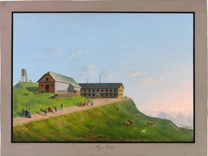
Rigi Kulm, Inn
Text

No trip through Switzerland would be complete without a visit to the Rigi. As early as the 17th and 18th centuries, the Rigi mountain range was a well-known pilgrimage and health resort. When the Zurich artist and panorama painter Heinrich Keller (1778–1862) published his first panorama of Rigi-Kulm in 1804, he introduced the breathtaking view from the summit to a wide audience. It was also Keller who, in the same year, founded a committee to facilitate the construction—already initiated by the Rigi guide Joseph Martin Bürgi—of an inn on Rigi-Kulm (just below the summit). This committee included notable members, such as the physician and travel writer Johann Gottfried Ebel and the engineer Hans Conrad Escher (1767–1823). Thanks to numerous donations from the public, Bürgi was finally able to complete the construction of his inn on Rigi-Kulm as early as 1816. As we learn from Baedeker’s travel guide, the inn was extremely popular among travelers, as it allowed them to experience the Rigi panorama with the magic of sunrise:

"In August and September, when the weather is fine, the Kulmhaus is teeming with travelers, so that good service is out of the question and one must count oneself lucky to have found a bed at all. However, a second inn is to be built up there. To the cheerful observer, this jumble of travelers provides a unique form of entertainment. People from every walk of life—from the humble artisan to those of princely lineage—find themselves gathered here for the same purpose. All the European languages can be heard swirling together. [...] An hour before sunrise, the alphorn sounds. Now a new rush and scramble begins in the house. Everyone fears missing the sunrise; little by little, the rooms empty out, and with sleepy eyes, wrapped in shawls, coats, or even blankets, everyone hurries up to the summit. A few even climb the wooden tower or signal tower to greet the first rays of the sun a few seconds earlier. Blessed is the one upon whom they shine unobstructed! Not everyone who climbed the Rigi with high hopes can boast of this good fortune, and the Rigi guestbook bears witness to many disappointed expectations turned into fog, rain, or snow."

Ort auf moderner Karte
GEOMETRYCOLLECTION (POINT (8.483098 47.054855), LINESTRING (8.483098 47.054855, 8.485609 47.055864))
Camera Settings (3D)
{"landscape":{"viewpoint":{"bounds":[[8.492656913868814,46.640195464453],[9.818605384010084,47.67107111921865]],"bearing":68.30032807163059,"pitch":74.0270700574812,"zoom":13.900340158837244,"center":{"lng":8.528912598539932,"lat":47.06706133745425},"cam":{"center":{"lng":10.516877306625304,"lat":47.260880006730076},"zoom":7.216850121039441,"bearing":0},"cameraToCenterDistance":1176.262045899493,"cameraPosition":{"lngLat":{"lng":8.480595996767505,"lat":47.053963283681185},"altitude":1809.4940740037919},"cameraTargetElevation":682.134884839226},"image.scale":73},"portrait":{"image.scale":83,"viewpoint":{"bounds":[[8.48779608157642,46.8377860291362],[9.908623833951765,47.75666987272956]],"bearing":56.43582426498414,"pitch":74.03598248891082,"zoom":13.906775058027915,"center":{"lng":8.522915418463782,"lat":47.072938465681744},"cameraToCenterDistance":1176.262045899493,"cameraPosition":{"lngLat":{"lng":8.479775018392132,"lat":47.05344035165487},"altitude":1803.7432505109305},"cameraTargetElevation":682.134884839226}},"square":{"viewpoint":{"bounds":[[8.488947913118494,46.84239658068],[9.882662574081508,47.74381720018704]],"bearing":56.43582426498414,"pitch":74.03598248891082,"zoom":13.934571500106806,"center":{"lng":8.523397081654139,"lat":47.07305153613868},"cam":{"center":{"lng":10.830845499162876,"lat":47.41884951600301},"zoom":6.943655209379641,"bearing":0},"cameraToCenterDistance":1176.262045899493,"cameraPosition":{"lngLat":{"lng":8.481079912695094,"lat":47.05392560419074},"altitude":1782.3377094614352},"cameraTargetElevation":682.134884839226},"image.scale":69}}
Quellen

Karl Baedeker, Die Schweiz. Handbüchlein für Reisende, Coblence 1844, p. 104; Roland Flückiger-Seiler, Hotelträume zwischen Gletschern und Palmen. Schweizer Tourismus und Hotelbau 1830-1920, Baden 2001, pp. 134–135; Erwin Horat, "Rigi", in: Historisches Lexikon der Schweiz (HLS), version dated Jan. 4, 2012 [Sept. 15, 2025]
Bilder
nb-477302
Titel
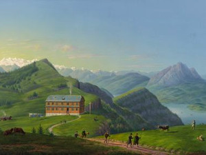
Rigi Staffel, Inn
Text

Due to the large influx of visitors, the inn on the Rigi-Kulm quickly reached capacity. The construction of additional lodging on the Rigi-Staffel provided a solution: Joseph Blasius Schreiber opened the first small building on the Staffel in 1817. However, in his 1839 travel guide, John Murray warned that the Rigi-Staffel’s lower elevation made it an unfavorable location for sunrise excursions:

"All the main trails converge in front of the Staffelhaus, a modest inn where travelers sometimes have to spend the night because the inn at the summit is overcrowded. It is a half-hour walk below the Kulm, and it is not a good idea to stop there beforehand, since those who stay the night must get up half an hour earlier the next morning if they want to see the sunrise from the summit."

Ort auf moderner Karte
GEOMETRYCOLLECTION (POINT (8.479601 47.054643), LINESTRING (8.479601 47.054643, 8.464278 47.047817))
Camera Settings (3D)
{"landscape":{"viewpoint":{"bounds":[[7.926600445979915,46.78717907070575],[8.478756504157616,47.159487360805514]],"bearing":-119.48713497336551,"pitch":64.48078546873633,"zoom":14.521376004443235,"center":{"lng":8.457236733921036,"lat":47.0462555283907},"cam":{"center":{"lng":8.692605016871681,"lat":47.010788065209596},"zoom":8.691140740821805,"bearing":0},"cameraToCenterDistance":1176.262045899493,"cameraPosition":{"lngLat":{"lng":8.484863977143647,"lat":47.056899795011105},"altitude":1830.153814669366},"cameraTargetElevation":682.134884839226},"image.scale":57},"portrait":{"viewpoint":{"bounds":[[7.946898946999511,46.79691963629958],[8.476821950003625,47.15420084722473]],"bearing":-119.48713497332143,"pitch":64.46655509208728,"zoom":14.58019001839705,"center":{"lng":8.45616362340769,"lat":47.04553825353406},"cameraToCenterDistance":1176.262045899493,"cameraPosition":{"lngLat":{"lng":8.482684096020165,"lat":47.05575628013068},"altitude":1784.8821306681607},"cameraTargetElevation":682.134884839226},"image.scale":61},"square":{"viewpoint":{"bounds":[[7.939402400104399,46.793375077173465],[8.476544399985954,47.15554172833839]],"bearing":-119.4871349734072,"pitch":64.47381833064784,"zoom":14.560913771743145,"center":{"lng":8.45560727189445,"lat":47.045391815564756},"cam":{"center":{"lng":8.841977072036485,"lat":47.02280935629008},"zoom":8.319214996540214,"bearing":0},"cameraToCenterDistance":1176.262045899493,"cameraPosition":{"lngLat":{"lng":8.482486097061326,"lat":47.0557479262184},"altitude":1799.4215947707985},"cameraTargetElevation":682.134884839226},"image.scale":76},"null":{"viewpoint":{"bounds":[[7.926541215339427,46.78714876160069],[8.478756164801325,47.15950770685802]],"bearing":-119.48713497342828,"pitch":64.48787263967034,"zoom":14.521461182266306,"center":{"lng":8.457236733918535,"lat":47.04625552839141},"cam":{"center":{"lng":8.40194431092877,"lat":46.9887597690589},"zoom":9.988796182609095,"bearing":0},"cameraToCenterDistance":1176.262045899493,"cameraPosition":{"lngLat":{"lng":8.484863977141146,"lat":47.056899795011844},"altitude":1829.7885855766035},"cameraTargetElevation":682.134884839226}}}
Quellen

John Murray, Handbook for Travellers in Switzerland, and the Alps of Savoy and Piedmont, London 1839, p. 67; Roland Flückiger-Seiler, Hotelträume zwischen Gletschern und Palmen. Schweizer Tourismus und Hotelbau 1830-1920, Baden 2001, pp. 134–135

Bilder
zbz-990114201710205508
Titel
Rigi Kaltbad, Inn
Text

Rigi-Kaltbad is located southwest of Rigi-Kulm and can be reached via the Weggiser Rigiweg trail, starting at the Weggiser Schifflände on Lake Lucerne. This route, which had served as an agricultural and pilgrimage path since the Middle Ages, was expanded into a transport route to the Rigi between 1818 and 1820 at the initiative of the Weggis boatmen. Along the new road, well-to-do guests were carried to the popular summit by palanquin or on horseback. This so-called “Rigi service,” which involved not only porters but also hotel staff, shoe shiners, guides, and souvenir vendors, quickly became the largest source of income for the local population. Subsequently, in 1825, the Zimmermann brothers from Vitznau built a stone inn in Rigi-Kaltbad. In 1834, Josef Franz Lorenz Segesser (1780–1849) from Lucerne acquired the inn and opened 1838 a new wooden building that, in keeping with Rigi’s tradition as a health resort, offered spa treatments in addition to room and board:

"A new wooden inn with 26 rooms and 6 baths was recently built. In the past, it was customary for patients to lie down in the bath fully clothed and then go for a walk in the sun until their clothes had dried on their backs. Today, however, this method is no longer considered essential for healing. Near the cold bath is a small chapel dedicated to the Virgin Mary, to which pilgrims make the pilgrimage and where a daily Mass is celebrated for the shepherds on the Rigi."

Ort auf moderner Karte
GEOMETRYCOLLECTION (POINT (8.469646 47.044697), LINESTRING (8.469646 47.044697, 8.442991 47.039232))
Camera Settings (3D)
{"landscape":{"image.scale":67,"viewpoint":{"bounds":[[8.472087928994796,47.03591673220478],[8.486329124058841,47.0503427867373]],"bearing":-93.42952093560997,"pitch":84.99908976320515,"zoom":17.87521766747014,"center":{"lng":8.46972900000003,"lat":47.04464900000002},"cam":{"center":{"lng":8.48572642969475,"lat":47.043717564144885},"zoom":14.67209269916972,"bearing":0},"cameraToCenterDistance":980.0396626728683,"cameraPosition":{"lngLat":{"lng":8.47257912993021,"lat":47.044765389614184},"altitude":1521.572082932747},"cameraTargetElevation":1502.640799782265}},"portrait":{"viewpoint":{"bounds":[[8.471687400581516,47.03247021466717],[8.491264150419596,47.052637614373225]],"bearing":-93.42952093601025,"pitch":84.9973447495884,"zoom":18.138511277267707,"center":{"lng":8.469323397144308,"lat":47.044684284296466},"cameraToCenterDistance":1176.262045899493,"cameraPosition":{"lngLat":{"lng":8.472173527074489,"lat":47.04480067383366},"altitude":1521.5787099607753},"cameraTargetElevation":1502.640799782265}},"square":{"viewpoint":{"bounds":[[8.470657175054953,47.04138441400161],[8.482761659197791,47.0506007298477]],"bearing":-112.6295209360102,"pitch":83.9973447495884,"zoom":19.7150184204294,"center":{"lng":8.470014293622285,"lat":47.04477029684588},"cam":{"center":{"lng":8.49099667709828,"lat":47.04707448189049},"zoom":13.790905026396528,"bearing":0},"cameraToCenterDistance":1176.262045899493,"cameraPosition":{"lngLat":{"lng":8.470896447479703,"lat":47.045020883149505},"altitude":1510.2555459969271},"cameraTargetElevation":1502.640799782265}}}
Quellen

John Murray, Handbook for Travellers in Switzerland, and the Alps of Savoy and Piedmont, London 1839, p. 66; Erwin Horat, "Rigi", in: Historisches Lexikon der Schweiz (HLS), version dated Jan. 4, 2012 [Sept. 15, 2025]; Roland Flückiger-Seiler, Hotelträume zwischen Gletschern und Palmen. Schweizer Tourismus und Hotelbau 1830-1920, Baden 2001, pp. 134–135; https://www.prorigi.ch/berg/weggiser-rigiweg [September 16, 2025]

Bilder
zbz-990113889550205508
Titel
Rigi Scheidegg, Hotel
Text

Far from the hustle and bustle of Rigi-Kulm, Rigi-Scheidegg and its Kurhaus—which opened in 1830—were praised in the 1863 edition of Baedeker for both their outstanding views and their various spa treatments —such as soothing whey baths and cold showers:

"Of all these inns, the stately Curhaus on Rigi-Scheideck [...] deserves special recommendation [...] for its friendly hosts, good food, and magnificent view—the most beautiful after that of Rigi-Kulm [...]: On the long ridge of the Rigi that continues to the north and flattens out toward Lake Lowerz, at Rigi-Scheideck (5,073′), stands the [...] fine Curhaus with an excellent view—admittedly more limited than from the Kulm (which obscures part of the view toward the flat Swiss plains), but encompassing the entire mountain panorama and extending to individual scenic points that are not visible from the Kulm itself. [...] Rigikulm, Rossberg, Hochfluh, and Fitznauer-Stock stand out particularly in the foreground. Of all Switzerland’s health resorts, Scheideck is almost the most popular; it is a charming retreat, completely secluded from the hustle and bustle of the world on Rigikulm."

Ort auf moderner Karte
GEOMETRYCOLLECTION (POINT (8.519638 47.027872), LINESTRING (8.519638 47.027872, 8.535735 47.027433))
Camera Settings (3D)
{"landscape":{"viewpoint":{"bounds":[[5.414207905024341,45.9159013775174],[8.521074052284604,49.25050504151807]],"bearing":92.4122833220947,"pitch":80.02483993220133,"zoom":15.853349826393101,"center":{"lng":8.531094807453655,"lat":47.02764516506576},"cam":{"center":{"lng":11.408675517428065,"lat":47.94138443101954},"zoom":5.5108823063085195,"bearing":0},"cameraToCenterDistance":1176.262045899493,"cameraPosition":{"lngLat":{"lng":8.517347983179718,"lat":47.02803991465248},"altitude":1686.0613293567035},"cameraTargetElevation":1502.640799782265}},"square":{"viewpoint":{"bounds":[[8.521548105962637,43.45857326563629],[13.27223130663873,48.74147848252318]],"bearing":91.61228332211066,"pitch":79.52439298522738,"zoom":15.935921608615622,"center":{"lng":8.531103653025099,"lat":47.02767058841985},"cam":{"center":{"lng":16.50425348414788,"lat":46.59321905513764},"zoom":5.174455430059445,"bearing":0},"cameraToCenterDistance":1176.262045899493,"cameraPosition":{"lngLat":{"lng":8.51813560551767,"lat":47.02791939694961},"altitude":1684.4535498734433},"cameraTargetElevation":1502.640799782265}},"portrait":{"viewpoint":{"bounds":[[8.520835923893486,43.10579994252021],[13.725412151616894,48.90222680143805]],"bearing":91.61228332211066,"pitch":79.52439298522738,"zoom":15.804275851996543,"center":{"lng":8.531304434017557,"lat":47.02764021309116},"cameraToCenterDistance":1176.262045899493,"cameraPosition":{"lngLat":{"lng":8.517097383838262,"lat":47.02791279356177},"altitude":1701.8245498580673},"cameraTargetElevation":1502.640799782265}}}
Quellen

Karl Baedeker, Die Schweiz, nebst den angrenzenden Theilen von Oberitalien, Savoyen und Tirol. Handbuch für Reisende, Coblence 1863, p. 74, p. 81; Erwin Horat, "Rigi", in: Historisches Lexikon der Schweiz (HLS), version dated Jan. 4, 2012 [Sept. 15, 2025]

Bilder
nb-1000267
Titel
Rigi Klösterli, Inn
Text

"Schwert at the Klösterli [...], ¾ St. east of the Staffelhaus; decent and cheaper than at the Staffelhaus; lodging 3½ fr. The Sonne in the same location is also highly recommended; prices are the same as at the Schwert. Although the Klösterli has no view, it is less exposed to fog than the Staffel or Kulm; it is often quite clear here, while thick fog swirls around the higher parts of the mountain [...]." 

The Hotel Schwert, mentioned in the 1863 Baedeker guide, was built in 1822 as an enlarged replacement for the previous hotel by Joseph Blasius Schreiber, who had previously been responsible for constructing a hotel on the Staffel. Located slightly lower than the summit lodgings on the Rigi, the Klösterli was a popular stopover. In addition, the inns at the Klösterli offered various whey cures. The name “Klösterli” derives from the pilgrimage chapel of Maria zum Schnee, founded in 1689, which served as an important gathering place for the local population:

"On Sundays, two Masses are celebrated at daybreak, the third at 7 a.m.; at 9 a.m., the fourth Mass is held with a sermon. All the alpine herdsmen from the mountain gather for this service, especially on the church’s patron saint’s day (July 22), when Swiss wrestling matches also take place."


Ort auf moderner Karte
GEOMETRYCOLLECTION (POINT (8.488013 47.042931), LINESTRING (8.488013 47.042931, 8.483764 47.043743))
Camera Settings (3D)
{"landscape":{"viewpoint":{"bounds":[[8.490095831778063,46.66653074829668],[8.951487861469303,47.04334697868694]],"bearing":-59.02004076890568,"pitch":82.560895500767,"zoom":16.058796563609263,"center":{"lng":8.481987329377944,"lat":47.04517688836762},"cam":{"center":{"lng":9.04380749014652,"lat":46.88046328591193},"zoom":9.254034116051464,"bearing":0},"cameraToCenterDistance":1323.1607699543977,"cameraPosition":{"lngLat":{"lng":8.49357381199485,"lat":47.040436473836195},"altitude":1342.2039500717901},"cameraTargetElevation":1208.500000000001},"image.scale":136},"portrait":{"image.scale":97,"viewpoint":{"bounds":[[8.48857483377418,46.72843876360196],[8.875039712724657,47.04387772375705]],"bearing":-59.020040768965266,"pitch":82.55433398287805,"zoom":16.32119980555236,"center":{"lng":8.48181678800043,"lat":47.04540163440791},"cameraToCenterDistance":1323.1607699543977,"cameraPosition":{"lngLat":{"lng":8.491476270737905,"lat":47.04144966532513},"altitude":1320.0660090678139},"cameraTargetElevation":1208.500000000001}},"square":{"viewpoint":{"bounds":[[8.490095831777523,46.66653074442672],[8.95148786612583,47.04334697868691]],"bearing":-59.02004076890568,"pitch":82.560895500767,"zoom":16.058796563609263,"center":{"lng":8.481987329376807,"lat":47.04517688836768},"cam":{"center":{"lng":9.198358142806626,"lat":46.89251342466477},"zoom":8.68993713558385,"bearing":0},"cameraToCenterDistance":1323.1607699543977,"cameraPosition":{"lngLat":{"lng":8.493573811993713,"lat":47.04043647383625},"altitude":1342.20395007179},"cameraTargetElevation":1208.500000000001},"image.scale":176}}
Quellen

Karl Baedeker, Die Schweiz, nebst den angrenzenden Theilen von Oberitalien, Savoyen und Tirol. Handbuch für Reisende, Coblence 1863, pp. 74–76; https://www.rigi.ch/attraktionen/wallfahrtskapelle-maria-zum-schnee-6567618fde [September 16, 2025]

Bilder
zbz-990114219080205508
Titel
Pilatus, Hotel Klimsenhorn
Text

"The Pilatus, once perhaps the best-known mountain in Switzerland and frequently climbed, later supplanted by the Rigi, is now one of the most visited peaks ever since (1858) Mr. Casp. Blättler built the Esel trail in the Rozloch [...] at a cost of 25,000 francs—a very comfortable path, equipped with several rest houses (with their own roofs), that is passable even for small carriages all the way to the Hôtel Klimsenhorn and impossible to miss [...] a small screw steamer owned by Mr. Blättler [...] now runs several times a day from Lucerne directly to Hergiswyl."

As can be learned from the 1863 edition of the Baedeker guide, Kaspar Blättler (1791–1872) was a pioneer of tourism on Mount Pilatus. The path to the Esel viewpoint on Mount Pilatus—described by Baedeker and expanded in 1858—connected two of his major infrastructure projects: In Rotzloch on Lake Lucerne, a spa resort had been established in the 1850s on Blättler’s initiative, for which the entrepreneur made use of a natural sulfur spring. On Mount Pilatus, he had the Hotel Klimsenhorn built between 1856 and 1860—the very first hotel on Lucerne’s local mountain. In the 19th century, it was visited by numerous distinguished guests, including the German composer Richard Wagner and Queen Victoria of England.

Ort auf moderner Karte
GEOMETRYCOLLECTION (POINT (8.251089 46.983018), LINESTRING (8.251089 46.983018, 8.250837 46.982378))
Camera Settings (3D)
{"landscape":{"viewpoint":{"bounds":[[0.6502046681194713,42.534755835481064],[8.41210751074874,46.983280616807974]],"bearing":-146.8133197957252,"pitch":80.48523681450263,"zoom":14.127205380944382,"center":{"lng":8.223713401654038,"lat":46.95449350281672},"cam":{"center":{"lng":6.929865735389313,"lat":44.99067413146841},"zoom":6.399519561938078,"bearing":0},"cameraToCenterDistance":1369.2676687453531,"cameraPosition":{"lngLat":{"lng":8.252758457562294,"lat":46.984796905096346},"altitude":1883.5317952061637},"cameraTargetElevation":1208.500000000001},"image.scale":52},"portrait":{"image.scale":92,"viewpoint":{"bounds":[[-0.06344367570608256,42.10040120919521],[8.429440633933154,46.98542065951429]],"bearing":-146.81331979573122,"pitch":80.46984212464946,"zoom":13.966369585533846,"center":{"lng":8.222732806640352,"lat":46.95324084152497},"cameraToCenterDistance":1369.2676687453531,"cameraPosition":{"lngLat":{"lng":8.255201816226105,"lat":46.98711619855331},"altitude":1964.368816880905},"cameraTargetElevation":1208.500000000001}},"square":{"image.scale":51,"viewpoint":{"bounds":[[5.157595919194932,45.212667720694355],[8.314385503260297,46.982934376336374]],"bearing":-146.81331979573122,"pitch":79.46984212464946,"zoom":14.225122153140624,"center":{"lng":8.225526154620866,"lat":46.956142183901136},"cam":{"center":{"lng":21.888580714741494,"lat":47.25987755752172},"zoom":3.7402855909775923,"bearing":0},"cameraToCenterDistance":1369.2676687453531,"cameraPosition":{"lngLat":{"lng":8.252580440354166,"lat":46.98436824620853},"altitude":1905.804019661994},"cameraTargetElevation":1208.500000000001}}}
Quellen

Karl Baedeker, Die Schweiz, nebst den angrenzenden Theilen von Piemont, der Lombardei und Tirol. Handbuch für Reisende, Coblence 1863, pp. 65–66; Erich Aschwanden, "Blättler, Kaspar," in: Historisches Lexikon der Schweiz (HLS), version dated Nov. 6, 2002 [Sept. 16, 2025]
Bilder
zbz-990113782750205508
Titel
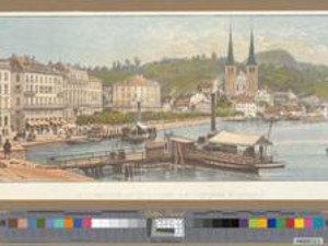
Lucerne, Hotel Schweizerhof and Hôtel d'Angleterre
Text

A major disaster in 1833 turned out to be a great stroke of luck for Lucerne’s hotel industry: At that time, part of the right bank of the Reuss burned down, severely damaging the city’s medieval architecture. However, this event led to innovative urban planning changes: the rubble from the fire was used to build up both banks of the Reuss into quays. On the site of the fire on the right bank, the burned-down Hotel Schwanen reopened in 1835 directly on the lakeshore—making Lucerne the first city to boast a lakeside inn with a panoramic view of the mountains. Lucerne’s tourism offerings were further enhanced in 1837 with the launch of the first steamboat on Lake Lucerne by the banker and merchant Kasimir Friedrich Knörr (1808–1882). Knörr skillfully positioned his boat landing stage directly in front of the Hotel Schwanen, allowing hotel guests to explore the area around Lake Lucerne without having to travel far.

Others also wanted to capitalize on this concentration of tourist attractions: In 1845, Josef Franz Lorenz Segesser and his sons opened the Hotel Schweizerhof, located next to the Schwanen and also offering a lake view, making it Lucerne’s first grand hotel. Segesser was also the owner of the Rigi Kaltbad inn and promoted tourism there as well by constructing the new spa building. The quay in front of the Schweizerhof was further expanded in the following years, allowing additional hotels to be built in the 1850s, such as the Hotel Englischer Hof ("Hôtel d’Angleterre").

Ort auf moderner Karte
GEOMETRYCOLLECTION (POINT (8.309038 47.052916), POINT (8.309038 47.052916), LINESTRING (8.309038 47.052916, 8.310475 47.054363))
Camera Settings (3D)
{"landscape":{"viewpoint":{"bounds":[[8.302445179859859,47.04843937910357],[8.315037156859148,47.0559558668287]],"bearing":49.81144422666308,"pitch":79.00673417509718,"zoom":22,"center":{"lng":8.302592115377024,"lat":47.04936125696966},"cam":{"center":{"lng":8.31520823215672,"lat":47.052700422958424},"zoom":14.896383499033776,"bearing":0},"cameraToCenterDistance":1323.1607699543977,"cameraPosition":{"lngLat":{"lng":8.30242577701003,"lat":47.049265517945},"altitude":546.562534267489},"cameraTargetElevation":543.3578242211618},"image.scale":136},"portrait":{"image.scale":135,"viewpoint":{"bounds":[[8.302445179859518,47.04843937910704],[8.315037156826293,47.05595586680292]],"bearing":49.81144422666308,"pitch":79.00673417509718,"zoom":22,"center":{"lng":8.30259211537657,"lat":47.04936125696966},"cameraToCenterDistance":1323.1607699543977,"cameraPosition":{"lngLat":{"lng":8.302425777009574,"lat":47.049265517945},"altitude":546.562534267489},"cameraTargetElevation":543.3578242211618}},"square":{"viewpoint":{"bounds":[[8.301798121656304,47.04096600553373],[8.423673542700556,47.11368222569024]],"bearing":49.81144423259514,"pitch":79.0034507880793,"zoom":18.723019324950283,"center":{"lng":8.303222364574822,"lat":47.04989027773499},"cam":{"center":{"lng":8.488883638831226,"lat":47.08713617358529},"zoom":10.610523029606938,"bearing":0},"cameraToCenterDistance":1323.1607699543977,"cameraPosition":{"lngLat":{"lng":8.30161002291078,"lat":47.048962267593225},"altitude":574.4307400956883},"cameraTargetElevation":543.3578242211618},"image.scale":176}}
Quellen

Roland Flückiger-Seiler, Hotelträume zwischen Gletschern und Palmen. Schweizer Tourismus und Hotelbau 1830–1920, Baden 2001, pp. 135–137; Markus Lischer: "Knörr, Kasimir Friedrich," in: Historisches Lexikon der Schweiz (HLS), version dated Jan. 25, 2018 [Oct. 3, 2025]; Markus Lischer; Ebbe Nielsen; Hermann Fetz; Konrad Wanner; Markus Trüeb: "Luzern (Gemeinde)," in: Historisches Lexikon der Schweiz (HLS), version dated Nov. 3, 2016 [Oct. 3, 2025]

Bilder
zbz-990114143180205508
Titel
Stoos, Hotel Fronalp
Text

The growing number of visitors to the Rigi and the launch of steamboat service on Lake Lucerne were major catalysts for tourism in Central Switzerland. In this region, the area around Stoos developed into a popular tourist destination: the alpine meadows of the Stoos high plateau had long served as summer pastures for herders from Arth and Schwyz. Thanks to its location above Morschach and its proximity to Brunnen, Stoos was connected to two well-served resorts on Lake Lucerne—and so, in 1852, likely inspired by the example of the Rigi, the Hotel Fronalp and a whey spa were opened in Stoos. After a small road was built from Morschach to Stoos in 1882–1883, this popular destination became accessible even by horse-drawn carriage:

"A new road leads from Morschach to Stoos (1,293 m), the northern spur of the Frohnalp [...], with beautiful views and varied walking trails, taking 2 hours (two-horse carriage from Brunnen in 2¼ hours, 20 francs; round trip 25–30 francs)."

Ort auf moderner Karte
GEOMETRYCOLLECTION (POINT (8.66612 46.976494), LINESTRING (8.66612 46.976494, 8.667631 46.983822))
Camera Settings (3D)
{"landscape":{"image.scale":176,"viewpoint":{"bounds":[[8.651279046019141,46.96066698560779],[8.665116061786108,46.9707339326871]],"bearing":14.837909165333713,"pitch":82.0592959635134,"zoom":21.47019625564636,"center":{"lng":8.663822410574511,"lat":46.97089107626715},"cameraToCenterDistance":1323.1607699543977,"cameraPosition":{"lngLat":{"lng":8.663741188780364,"lat":46.970681867649404},"altitude":1505.9975780624611},"cameraTargetElevation":1502.640799782265}},"portrait":{"image.scale":129,"viewpoint":{"bounds":[[7.618378678659411,46.751798932647375],[7.644923279678636,46.77425834162659]],"bearing":-18.492447400116365,"pitch":59.886131126364106,"zoom":17.780315301213086,"center":{"lng":7.636115887097077,"lat":46.7533310225748},"cam":{"center":{"lng":8.642873875138918,"lat":46.87374864415571},"zoom":7.119608251804025,"bearing":0},"cameraToCenterDistance":1323.1607699543977,"cameraPosition":{"lngLat":{"lng":7.637249783559071,"lat":46.751008109743736},"altitude":757.9660488954386},"cameraTargetElevation":600}}}
Quellen

Karl Baedeker,  Die Schweiz, nebst den angrenzenden Theilen von Oberitalien, Savoyen und Tirol. Handbuch für Reisende, Leipzig 1885, p. 76; Erwin Horat: "Stoos," in: Historisches Lexikon der Schweiz (HLS), version dated Nov. 26, 2013. Online: https://hls-dhs-dss.ch/de/articles/007447/2013-11-26/, accessed October 3, 2025.

Bilder
zbz-990113958230205508
Titel
Thun, Hôtel de Bellevue
Text

"The Freienhof and Falke inns in town, good second-class establishments; Hotel de Bellevue, just outside town at the steamboat landing, a newer first-class inn; nearby is the steamboat, both owned by the operator of the steamboat service on Lake Thun."

Although the Bernese Oberland had been one of the most popular travel destinations since the early days of Swiss tourism, the region had only a meager tourist infrastructure at the beginning of the 19th century. At that time, the roads along the lakeshore were in poor condition—in 1835, a road was finally built along the southern shore of the lake, connecting Thun with Interlaken. In the same year, the first steamboat on Lake Thun began operating, serving various landing stages. The steamboat service in Thun was operated by Johannes Knechtenhofer (1793–1865). His two brothers, Johann Jakob (1790–1867) and Johann Friedrich Knechtenhofer (1796–1871), were also pioneers of tourism: At their Hotel Bellevue, which opened in 1834, they welcomed travelers to Thun’s first modern hotel. Surrounded by an English-style park, the hotel flourished in the 1840s and 1850s and was a popular destination for members of the European aristocracy, such as the Prince of Wales (1857) and Emperor Napoleon III (1865).

Ort auf moderner Karte
GEOMETRYCOLLECTION (POINT (7.635404 46.754744), POINT (7.635404 46.754744), LINESTRING (7.635404 46.754744, 7.635174 46.755398))
Camera Settings (3D)
{"landscape":{"viewpoint":{"bounds":[[7.533535819022859,46.75187896355044],[7.6760032708472465,46.870279681449716]],"bearing":-20.89244740011577,"pitch":77.88613112636408,"zoom":17.38243157411124,"center":{"lng":7.635394304150736,"lat":46.754440271392156},"cameraToCenterDistance":1323.1607699543977,"cameraPosition":{"lngLat":{"lng":7.6372928947128855,"lat":46.75103242340043},"altitude":687.053859452347},"cameraTargetElevation":600},"image.scale":97},"portrait":{"image.scale":129,"viewpoint":{"bounds":[[7.618378678659411,46.751798932647375],[7.644923279678636,46.77425834162659]],"bearing":-18.492447400116365,"pitch":59.886131126364106,"zoom":17.780315301213086,"center":{"lng":7.636115887097077,"lat":46.7533310225748},"cam":{"center":{"lng":8.642873875138918,"lat":46.87374864415571},"zoom":7.119608251804025,"bearing":0},"cameraToCenterDistance":1323.1607699543977,"cameraPosition":{"lngLat":{"lng":7.637249783559071,"lat":46.751008109743736},"altitude":757.9660488954386},"cameraTargetElevation":600}}}
Quellen

Karl Baedeker, Die Schweiz. Handbüchlein für Reisende, Koblenz 1844, p. 144; Roland Flückiger-Seiler, Hotelträume zwischen Gletschern und Palmen. Schweizer Tourismus und Hotelbau 1830-1920, Baden 2001, pp. 72, 110–111; https://blog.nationalmuseum.ch/en/2023/08/showcasing-the-stunning-views-of-lake-thun/ [September 26, 2025]

Bilder
nb-817961
Titel
Tracht Near Brienz, Inns
Text

"Lake Brienz. It is 3 St. long and ½ St. wide; its most delicate fish is the Brienzling. – At the eastern end once stood the well-known village Kienholz, which was destroyed by landslides [sic] and rockfalls; now only a few huts remain there. – The Gaisbach plunges into the lake at Oberried, forming a beautiful cascade. – Coming from Meyringen, one boards a boat at Tracht."

Travelers needed lodging not only at their destinations—whether a city or a mountain peak—but also along the way. In his 1793 travel guide, Johann Gottfried Ebel recommends the village of Tracht as a landing site on Lake Brienz. As a waypoint on the transit route through the Bernese Oberland, travelers could board a boat there with the boatmen and boatwomen—or rest in one of the simple lodgings and begin their lake journey the following day. Around 1800, Tracht was not only a landing site for passengers but also an important transshipment point for freight.

Ort auf moderner Karte
GEOMETRYCOLLECTION (POINT (8.03633 46.753518), LINESTRING (8.03633 46.753518, 8.037382 46.754356))
Camera Settings (3D)
{"landscape":{"viewpoint":{"bounds":[[8.030922567124463,46.74654793458433],[8.09182752345285,46.78267754023403]],"bearing":49.37886623571069,"pitch":77.00384886793506,"zoom":18.90735863464576,"center":{"lng":8.032149818379708,"lat":46.751061674129915},"cam":{"center":{"lng":8.094281230516629,"lat":46.767120224025604},"zoom":12.58727550118532,"bearing":0},"cameraToCenterDistance":1323.1607699543977,"cameraPosition":{"lngLat":{"lng":8.030750381316182,"lat":46.75023921896144},"altitude":670.419648851187},"cameraTargetElevation":638},"image.scale":136},"portrait":{"image.scale":101,"viewpoint":{"bounds":[[7.240081526462063,46.343981057461264],[8.054158841922145,46.81218590744626]],"bearing":49.711614971148954,"pitch":83.49995095113725,"zoom":13.183776096809543,"center":{"lng":8.088519821683121,"lat":46.78369036357759},"cameraToCenterDistance":980.0396626728683,"cameraPosition":{"lngLat":{"lng":8.032392576132736,"lat":46.75110001311856},"altitude":638.3320802381725},"cameraTargetElevation":0}},"square":{"image.scale":129,"viewpoint":{"bounds":[[8.032617147003009,46.687683835871155],[8.445545572698592,46.96386723271783]],"bearing":56.823959958200696,"pitch":79.4558766628426,"zoom":17.284064690963167,"center":{"lng":8.036688632903378,"lat":46.753714633674036},"cam":{"center":{"lng":8.49091099897521,"lat":46.845094615500585},"zoom":9.651258101415989,"bearing":0},"cameraToCenterDistance":1323.1607699543977,"cameraPosition":{"lngLat":{"lng":8.0318918597537,"lat":46.75156596650547},"altitude":647.838061788515},"cameraTargetElevation":566.5701404264199}},"null":{"viewpoint":{"bounds":[[8.033774974760036,46.75136616577791],[8.042440261941323,46.756507544862416]],"bearing":49.37886623571069,"pitch":77.00384886793506,"zoom":21.7205988496671,"center":{"lng":8.0339495826222,"lat":46.75200832629611},"cam":{"center":{"lng":8.040495754913508,"lat":46.75411871532944},"zoom":16.37167704459349,"bearing":0},"cameraToCenterDistance":1323.1607699543977,"cameraPosition":{"lngLat":{"lng":8.033750476927281,"lat":46.75189131384573},"altitude":642.6124427491116},"cameraTargetElevation":638}}}
Quellen

Johann Gottfried Ebel, Anleitung auf die nützlichste und genussvollste Art in der Schweitz zu reisen, Zurich 1793, p. 31; Hans von Rütte, "Brienzersee", in: Historisches Lexikon der Schweiz (HLS), version dated Aug. 26, 2004 [Sept. 9, 2025]


Bilder
zbz-990054268770205508
Titel
Grindelwald, Hotel Bären
Text

The village of Grindelwald in the Bernese Oberland became a hotspot for alpinism in the second half of the 19th century and was particularly popular among Englishmen and Englishwomen. Grindelwald was an ideal starting point for tours of the region’s towering mountains and glaciers:

"Grindelwald, originally Gydisdorf (1,057 m), a large village (3,087 inhabitants) with widely scattered houses, is an excellent base for mountain tours and is also visited as a climatic health resort due to its sheltered location and mild climate. Nearly half the village burned down on August 18, 1892, during a violent Föhn wind, but reconstruction is proceeding vigorously."

At the top of the list of local hotels, the 1893 Baedeker guide mentions the Grand Hotel Bär (also known as "Hotel Bear"), which was rebuilt that same year—after large parts had been destroyed by the fire mentioned by Baedeker—as a spacious three-winged complex. The history of this hotel dates back to the late 18th century, but it experienced its heyday in the late 19th century. In 1867, Johannes Boss (1815–1900) from Grindelwald had acquired the property and began implementing his plans to expand it. In 1888, the resourceful hotelier opened an extension featuring a special heating system—an innovation that made the first winter season in Grindelwald possible and turned the village into a pioneer of winter sports.

Ort auf moderner Karte
GEOMETRYCOLLECTION (POINT (8.06519 46.632287), POINT (8.06519 46.632287), LINESTRING (8.06519 46.632287, 8.082632 46.627334))
Camera Settings (3D)
{"landscape":{"viewpoint":{"bounds":[[8.045319907449766,46.630222587828115],[8.06407031246357,46.6471810159492]],"bearing":110.51196915599304,"pitch":85.52311405500097,"zoom":18.665954245794154,"center":{"lng":8.06578268282692,"lat":46.632164382629526},"cam":{"center":{"lng":8.060959253600629,"lat":46.63919312380531},"zoom":14.942377045946348,"bearing":0},"cameraToCenterDistance":1323.1607699543977,"cameraPosition":{"lngLat":{"lng":8.063694061900264,"lat":46.63270095183748},"altitude":1235.4820616487627},"cameraTargetElevation":1222.1504058988048}},"portrait":{"viewpoint":{"bounds":[[8.043167112502971,46.63008599858048],[8.063628406098616,46.648591561092616]],"bearing":110.5119691558507,"pitch":85.51901346496777,"zoom":18.54132461755174,"center":{"lng":8.06549495944219,"lat":46.63220549388694},"cameraToCenterDistance":1323.1607699543977,"cameraPosition":{"lngLat":{"lng":8.063217899586562,"lat":46.632790472574555},"altitude":1236.6982224429362},"cameraTargetElevation":1222.1504058988048}},"square":{"viewpoint":{"bounds":[[8.04200907088844,46.63003286714789],[8.063393324381877,46.64937301329016]],"bearing":110.51196915541232,"pitch":85.51492045601148,"zoom":18.479015413372384,"center":{"lng":8.065341925463713,"lat":46.632248508076486},"cam":{"center":{"lng":8.0692138566736,"lat":46.64099717357357},"zoom":13.543993790139588,"bearing":0},"cameraToCenterDistance":1323.1607699543977,"cameraPosition":{"lngLat":{"lng":8.062964379323887,"lat":46.6328593011481},"altitude":1237.354134601949},"cameraTargetElevation":1222.1504058988048}}}
Quellen

Karl Baedeker, Die Schweiz, nebst den angrenzenden Theilen von Oberitalien, Savoyen und Tirol. Handbuch für Reisende, Leipzig 1893, pp. 156–157; Roland Flückiger-Seiler, Hotelträume zwischen Gletschern und Palmen. Schweizer Tourismus und Hotelbau, 1830–1920, Baden 2001, pp. 72, 128–131
Bilder
nb-481297
Titel
Faulhorn, Mountain Inn
Text

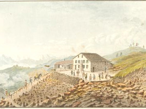
"The Faulhorn, a mountain 8,140 F. above sea level located between Lake Brienz and the Grindelwald Valley, has been climbed quite frequently in recent times—though not quite as often as the Rigi—especially since an inn was established at the summit. Admittedly, this inn does not by any means offer the same level of comfort as the Rigi inn and has only 24 beds, so that in the height of summer, some travelers must do without a private bed if one has not been reserved in advance. If you are traveling with women, it is absolutely necessary to secure beds for them beforehand. [...] The great advantage of the view from the Faulhorn is that one has the snow-capped giants of the Bernese Oberland right in front of one; one stands, as it were, right in the midst of them. On the other hand, although one can see Lake Brienz and part of Lake Thun, the vast expanse of Lake Lucerne and Lake Zug—which lends the view from the Rigi its wonderful charm of grace and loveliness—is missing. The ascent, the sights, and the activity at the summit and in the inn are similar to those at Rigikulm [...]."

Among mountain hotels, the Hotel Faulhorn is a true pioneering project: It is the first European inn located at over 2,000 meters above sea level—namely, on the 2,681-meter-high summit of the Faulhorn near Grindelwald in the Bernese Oberland. The project was initiated by Samuel Blatter (1778–1861), who already ran inns in Unterseen near Interlaken and in Grindelwald and applied to the Bernese government in 1822 for a license to operate an inn on the Faulhorn. By around 1830, the first inn had already opened; this is documented by a visit from the famous German musician and composer Felix Mendelssohn-Bartholdy on August 15, 1831. Blatter, however, had to relinquish the project because his business had since gone bankrupt. The inn on the Faulhorn, on the other hand, had a promising future ahead of it: with an extension opened in 1832, more guests could now be accommodated in greater comfort. Through promotional brochures and depictions of the inn, such as those by Kleinmeister Samuel Weibel (1771–1846), as seen here, and Heinrich Keller, the inn soon gained widespread renown.

Ort auf moderner Karte
GEOMETRYCOLLECTION (POINT (8.000128 46.674859), LINESTRING (8.000128 46.674859, 7.999506 46.674653))
Camera Settings (3D)
{"landscape":{"viewpoint":{"bounds":[[7.3093981551848515,46.312871432224256],[7.994407137932171,46.88836567543413]],"bearing":-112.87717812784155,"pitch":68.47191485371695,"zoom":14.39712241153769,"center":{"lng":7.965596104085847,"lat":46.66478184667224},"cam":{"center":{"lng":7.952263108597435,"lat":46.62513211943639},"zoom":9.346027347807762,"bearing":0},"cameraToCenterDistance":1338.6430880177995,"cameraPosition":{"lngLat":{"lng":8.002985264124504,"lat":46.67560746128362},"altitude":2724.2291975560483},"cameraTargetElevation":1502.640799782265},"camera.fov":51,"image.scale":54},"portrait":{"viewpoint":{"bounds":[[7.3244745235790845,46.3233709888174],[7.993838871984366,46.87746631752913]],"bearing":-112.87717812789354,"pitch":68.46317845696869,"zoom":14.429668754268526,"center":{"lng":7.965331765047097,"lat":46.664794229243824},"cameraToCenterDistance":1369.2676687453531,"cameraPosition":{"lngLat":{"lng":8.002720925085782,"lat":46.67561984137535},"altitude":2724.7746142612414},"cameraTargetElevation":1502.640799782265}},"square":{"viewpoint":{"bounds":[[7.327183666138012,46.3245338613429],[7.993735894994501,46.874525431997796]],"bearing":-113.0854605889694,"pitch":68.46317845696869,"zoom":14.438193245807689,"center":{"lng":7.965383329404972,"lat":46.664687917016295},"cam":{"center":{"lng":10.748818440934599,"lat":46.84393185586751},"zoom":5.983953862208887,"bearing":0},"cameraToCenterDistance":1369.2676687453531,"cameraPosition":{"lngLat":{"lng":8.002494960833474,"lat":46.67554241606595},"altitude":2717.57704038182},"cameraTargetElevation":1502.640799782265}}}
Quellen

Karl Baedeker, Die Schweiz. Handbüchlein für Reisende, Koblenz 1844, p. 164; Roland Flückiger-Seiler, Berghotels: zwischen Alpweide und Gipfelkreuz. Alpiner Tourismus und Hotelbau 1830-1920, 1830–1920. Baden 2015, pp. 150–152

Bilder
nb-873119
Titel
Geneva, Hôtel des Bergues
Text

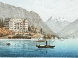
"Geneva now presents a very impressive sight when viewed from the lake, thanks to recently completed improvements, for which it owes a great deal to the influx of money from English travelers among its residents. On the right bank of the Rhône, an entirely new district has emerged—the Quartier des Bergues—with a beautiful row of tall buildings, including the Hôtel des Bergues, which faces the lake from a wide quay. The sight of this modern rival has sparked a race for improvement on the opposite bank. The unsightly houses that lined the lakeshore have been renovated and beautified, while a wide strip of land was reclaimed from the water to form a quay. This quay is connected to the Quai des Bergues by two beautiful bridges spanning the lake and is linked to a small island that was once part of the fortifications and is now occupied by a very poor-quality statue of Rousseau." 

With the urban expansion described by Murray, the city of Geneva modernized in the 19th century to welcome its guests—particularly those from England. As early as the mid-18th century, the city on Lake Geneva—Europe’s largest inland lake—had become one of Switzerland’s most popular destinations. The city’s location was exceptionally favorable as a starting point for excursions into the Mont Blanc region (first ascent in 1786) and as an important transit zone between the kingdoms of France and Sardinia. The expansion of the hospitality industry in Geneva was shaped by the pioneer Antoine-Jérémie Dejean, who opened the Hôtel d’Angleterre in 1765—the first hotel outside the city walls with a view of the Alps. In the new Bergues district, the Société des Bergues had Switzerland’s first grand hotel built between 1829 and 1834. Designed by the Lyon architect Augustin Miciol (1804–1876), the Neoclassical building blended seamlessly into the landscape of the new block on the Quai des Bergues—and served as a model for numerous other Swiss hotel buildings.

Ort auf moderner Karte
GEOMETRYCOLLECTION (POINT (6.147817 46.206975), LINESTRING (6.147817 46.206975, 6.146851 46.206337))
Camera Settings (3D)
{"landscape":{"viewpoint":{"bounds":[[5.857474974124273,46.05674833076259],[6.1506487721932785,46.26592505411233]],"bearing":-119.87358106319384,"pitch":79.49840492988592,"zoom":17.79284039544258,"center":{"lng":6.147730308970836,"lat":46.20686960919204},"cam":{"center":{"lng":6.181098706825878,"lat":46.175423149999915},"zoom":10.121588598181594,"bearing":0},"cameraToCenterDistance":1323.1607699543977,"cameraPosition":{"lngLat":{"lng":6.151223423566506,"lat":46.208258194489105},"altitude":427.70087272084146},"cameraTargetElevation":370.2373867485721},"image.scale":89},"portrait":{"viewpoint":{"bounds":[[5.857474973007328,46.056748331267045],[6.150648772195979,46.265925054406296]],"bearing":-119.87358106319384,"pitch":79.49840492988592,"zoom":17.79284039544258,"center":{"lng":6.1477303089734505,"lat":46.206869609191585},"cameraToCenterDistance":1323.1607699543977,"cameraPosition":{"lngLat":{"lng":6.151223423569093,"lat":46.20825819448862},"altitude":427.7008727208419},"cameraTargetElevation":370.2373867485721},"image.scale":91},"square":{"viewpoint":{"bounds":[[6.014881598469088,46.13837056741755],[6.1489732026344655,46.234000628169554]],"bearing":-119.87358106319635,"pitch":79.50033686206382,"zoom":18.92319135654905,"center":{"lng":6.147640000448291,"lat":46.206982665990296},"cam":{"center":{"lng":6.220719632907446,"lat":46.197167234878464},"zoom":10.47271132350298,"bearing":0},"cameraToCenterDistance":1323.1607699543977,"cameraPosition":{"lngLat":{"lng":6.1492356811868945,"lat":46.20761698513556},"altitude":396.4821418029879},"cameraTargetElevation":370.2373867485721},"image.scale":49}}
Quellen

John Murray, Handbook for Travellers in Switzerland, and the Alps of Savoy and Piedmont, London 1839, p. 183; Roland Flückiger-Seiler, Hotelträume zwischen Gletschern und Palmen. Schweizer Tourismus und Hotelbau 1830-1920, Baden 2001, pp. 88–98
Bilder
nb-477618
Titel
Villeneuve, Hôtel Byron
Text

"Between Chillon and Villeneuve, the Hôtel Byron, a large inn, is frequently used as a guesthouse [...]. The semicircle formed by the lake here is reminiscent of the Bay of Naples, while Chillon resembles Castel Nuovo. The walled island, located not far from the confluence with the Rhône, about 100 paces from the shore, 30 Schr. long and 20 paces wide, was laid out 100 years ago by a lady and planted with three acacia trees; it offers a panoramic view."

Three factors made the small town of Villeneuve on Lake Geneva an attractive destination for travelers in the early 19th century: First, the town was located in the immediate vicinity of Chillon Castle, which had gained fame throughout Europe thanks to its appearance in Lord Byron’s poem "The Prisoner of Chillon" (1816). Second, Villeneuve had always been situated on the Geneva–Chamonix route, which travelers typically took to reach the Mont Blanc region, and on the Simplon route from Geneva to Milan. And third: Starting in 1828, these routes could be shortened by taking a steamboat from Geneva to Villeneuve. In the still-uninhabited area between Chillon Castle and the small town of Villeneuve, the merchant Vincent Masson-Vallon began construction of the Hotel Byron in 1837—financial difficulties delayed the project, but its opening was finally celebrated in 1841. Modeled after the Hotel des Bergues in Geneva, the imposing Hotel Byron was also built in the Neoclassical style.

Ort auf moderner Karte
GEOMETRYCOLLECTION (POINT (6.929604 46.411118), LINESTRING (6.929604 46.411118, 6.930871 46.410393))
Camera Settings (3D)
{"landscape":{"viewpoint":{"bounds":[[6.909420403888049,46.415086188239],[6.927633627608145,46.428996574929386]],"bearing":142.2768438085401,"pitch":84.01209115594577,"zoom":19.66739194633448,"center":{"lng":6.925420510514186,"lat":46.41468521604722},"cam":{"center":{"lng":6.923644810838823,"lat":46.4224442942413},"zoom":15.233971956530437,"bearing":0},"cameraToCenterDistance":1323.1607699543977,"cameraPosition":{"lngLat":{"lng":6.92474062328526,"lat":46.415291181584536},"altitude":495.89558794547054},"cameraTargetElevation":486.960267097691},"image.scale":165},"portrait":{"viewpoint":{"bounds":[[6.909393178293186,46.41508608876353],[6.927638705388432,46.429020927564835]],"bearing":142.2768438085401,"pitch":84.00842532225502,"zoom":19.667382261409106,"center":{"lng":6.925420510517142,"lat":46.41468521604426},"cameraToCenterDistance":1323.1607699543977,"cameraPosition":{"lngLat":{"lng":6.924740623288216,"lat":46.41529118158155},"altitude":495.90109827443666},"cameraTargetElevation":486.960267097691},"image.scale":135},"square":{"viewpoint":{"bounds":[[6.909393178915167,46.415086088762536],[6.927638705321698,46.4290209272946]],"bearing":142.2768438085401,"pitch":84.00842532225502,"zoom":19.667382261409106,"center":{"lng":6.925420510517142,"lat":46.41468521604364},"cam":{"center":{"lng":6.937401071849166,"lat":46.4235390854561},"zoom":13.350315552356697,"bearing":0},"cameraToCenterDistance":1323.1607699543977,"cameraPosition":{"lngLat":{"lng":6.924740623288216,"lat":46.415291181580926},"altitude":495.9010982744368},"cameraTargetElevation":486.960267097691},"image.scale":153}}
Quellen

Karl Baedeker, Die Schweiz, Handbuch für Reisende, Koblenz 1853, p. 200; Roland Flückiger-Seiler, Hotelträume zwischen Gletschern und Palmen. Schweizer Tourismus und Hotelbau 1830-1920, Baden 2001, p. 105

Bilder
zbz-990103400800205508
Titel
Zermatt, a village with hotels
Text

"Along with Chamonix and Grindelwald, Zermatt offers some of the most magnificent views of the glacial world. It may fall short of the Bernese Oberland in terms of the varied diversity of its valleys and lakes, nor can it rival it in the beauty and grandeur of its mountain forms. Opinions may therefore differ regarding its scenic beauty. It is undeniable, however, that at no other easily accessible location does one find oneself transported so directly into the heart of the high mountains, and that the panoramic view from the Gorner Ridge offers an almost unrivaled spectacle of overwhelming grandeur." 

The first inn in the Valais mountain village of Zermatt is documented in 1839 as "Laubers Wirtshaus": At that time, the village doctor, Josef Lauber, received permission from the Valais State Council to open his home as lodging for travelers. In the 1850s and 1860s, the mountain peaks around Zermatt and in the surrounding Mattertal valley were literally stormed, creating an urgent need for more lodging for mountaineers and travelers. This led to a small construction boom in the Valais mountain villages: In Zermatt in 1853, Alexander Seiler (1820–1891), a native of Goms, leased Lauber’s inn. Shortly thereafter, with the help of his brother Franz, he purchased it and renamed it the "Hotel Mont Cervin." This acquisition marked the beginning of the Seiler hotel empire: later additions included the Zermatterhof and the Hotel Monte Rosa in Zermatt, as well as numerous other inns throughout the Valais Alps. The expansion of the hospitality industry was also aided by the construction of the cogwheel railway between Visp and Zermatt in 1892.

Ort auf moderner Karte
GEOMETRYCOLLECTION (POINT (7.767443 46.037614), LINESTRING (7.767443 46.037614, 7.741341 46.011876))
Camera Settings (3D)
{"landscape":{"image.scale":52,"viewpoint":{"bounds":[[7.3500236425076935,45.794435352994014],[7.784431440593494,46.037903772220375]],"bearing":-148.13042542625726,"pitch":74.9468426849017,"zoom":15.729367823866195,"center":{"lng":7.759507309991932,"lat":46.02843833856454},"cam":{"center":{"lng":7.692720198866539,"lat":45.926351824437944},"zoom":10.605119310631146,"bearing":0},"cameraToCenterDistance":1369.2676687453531,"cameraPosition":{"lngLat":{"lng":7.768543150738424,"lat":46.03852831034959},"altitude":1857.9775023080347},"cameraTargetElevation":1502.640799782265}},"portrait":{"viewpoint":{"bounds":[[7.345598432015578,45.792114353378366],[7.784620722840202,46.03818185253658]],"bearing":-148.13042542626778,"pitch":74.93309293222293,"zoom":15.712225683655591,"center":{"lng":7.75942833229567,"lat":46.028603693937356},"cameraToCenterDistance":1369.2676687453531,"cameraPosition":{"lngLat":{"lng":7.768571587109932,"lat":46.03881356920729},"altitude":1862.5445752528444},"cameraTargetElevation":1502.640799782265}},"square":{"viewpoint":{"bounds":[[7.353311808626046,45.79642747306457],[7.784084828586941,46.03787080533368]],"bearing":-148.13042542625158,"pitch":74.9193892017772,"zoom":15.737706224293229,"center":{"lng":7.759362409338337,"lat":46.02846065769046},"cam":{"center":{"lng":9.564613311091989,"lat":46.076883423466796},"zoom":6.613743892531927,"bearing":0},"cameraToCenterDistance":1369.2676687453531,"cameraPosition":{"lngLat":{"lng":7.7683450171903985,"lat":46.0384911877174},"altitude":1856.5589130450935},"cameraTargetElevation":1502.640799782265}}}
Quellen

Karl Baedeker, Die Schweiz, nebst den angrenzenden Theilen von Oberitalien, Savoyen und Tirol. Handbuch für Reisende, Leipzig 1885, pp. 299–300; Roland Flückiger-Seiler, Hotelträume zwischen Gletschern und Palmen. Schweizer Tourismus und Hotelbau 1830-1920, Baden 2001, pp. 154–165; Stephan Seiler, Die Seiler-Saga. Eine Hoteliersfamilie prägt den Tourismus im Oberwallis. Zurich 2024, pp. 53–58, 120–121, 163–167

Bilder
zbz-990108744600205508
Titel
St. Moritz, the spa town and village with hotels
Text

"Bad St. Moritz (1,769 m) owes its origins to the acidulous spring, which rises at the foot of Piz Rosatsch. As early as 1539, Paracelsus described it as the strongest spring in Europe, and it surpasses Schwalbach and Pyrmont in carbon dioxide content and alkaline salts. The water is used for bathing and drinking. The bathing crowd is thoroughly international. At this high altitude, the spa season lasts only from mid-June to mid-September; warm clothing is absolutely necessary for spa guests, as snow and frost can occur even in August."

As described in the 1885 edition of the Baedeker travel guide, the Engadine mountain village of St. Moritz owes its popularity to its mineral springs. In 1832, the first spa house opened in St. Moritz, and starting in 1856, a restaurant was also available to spa guests. With the Grand Hotel des Bains, inaugurated in 1864, St. Moritz gained its first prestigious spa hotel. In St. Moritz, too, a hotel pioneer was instrumental in driving the tourism industry forward: Johannes Badrutt, who came from a humble background Johannes Badrutt (1819–1889) purchased the Pension Faller in St. Moritz in 1858 and subsequently expanded it into the Hotel-Pension Engadiner Kulm—thus creating, together with his wife Anna Maria (née Donatsch), one of Switzerland’s first luxury hotels. Badrutt’s interest in technological innovations also contributed to the Kulm Hotel’s luxury: in 1879, the hotel boasted Switzerland’s very first electric lighting system!

Ort auf moderner Karte
GEOMETRYCOLLECTION (POINT (9.846645 46.485332), LINESTRING (9.846645 46.485332, 9.83755 46.490769))
Camera Settings (3D)
{"landscape":{"viewpoint":{"bounds":[[9.836877749867284,45.37540554694695],[11.149194828851705,46.49408952246523]],"bearing":-49.12806440191264,"pitch":83.0390952332774,"zoom":14.418136269236351,"center":{"lng":9.815015808658018,"lat":46.504224896279965},"cam":{"center":{"lng":11.069868021058852,"lat":45.98372518335597},"zoom":8.404571734060017,"bearing":0},"cameraToCenterDistance":1369.2676687453531,"cameraPosition":{"lngLat":{"lng":9.848025250046533,"lat":46.48455975423252},"altitude":1910.5538426160686},"cameraTargetElevation":1502.640799782265}},"portrait":{"viewpoint":{"bounds":[[9.355699197897223,46.48400734060189],[9.84864977923155,46.89378992181136]],"bearing":-54.144602008797676,"pitch":75.57435140578646,"zoom":15.29720575593165,"center":{"lng":9.831236951608275,"lat":46.49302194413619},"cameraToCenterDistance":1323.1607699543977,"cameraPosition":{"lngLat":{"lng":9.84937398264367,"lat":46.48399741903046},"altitude":1943.2925417542592},"cameraTargetElevation":1502.640799782265},"image.scale":113},"square":{"viewpoint":{"bounds":[[9.837760158895804,44.588173951906214],[12.034609262198842,46.493630362372784]],"bearing":-49.507863382834444,"pitch":82.07435140578646,"zoom":14.357887781915862,"center":{"lng":9.816145534377227,"lat":46.50304900702213},"cam":{"center":{"lng":13.210045129279763,"lat":45.730344428675494},"zoom":6.438566360044728,"bearing":0},"cameraToCenterDistance":1323.1607699543977,"cameraPosition":{"lngLat":{"lng":9.849520304364972,"lat":46.48343064817999},"altitude":1970.2574339170696},"cameraTargetElevation":1502.640799782265},"image.scale":140}}
Quellen

Karl Baedeker, Die Schweiz, nebst den angrenzenden Theilen von Oberitalien, Savoyen und Tirol. Handbuch für Reisende, Leipzig 1885, pp. 367-368; Jürg Rageth; Silvio Margadant, "St. Moritz," in: Historisches Lexikon der Schweiz (HLS), version dated Jan. 21, 2011 [Oct. 6, 2025]
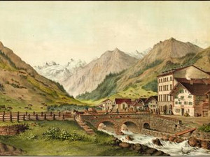
Bilder
nb-477071
Titel
Klosters, Hotel Silvretta
Text

Toward the end of the 19th century, the Engadin was known not only for its mineral springs and luxury hotels, but increasingly also as a center for winter sports. In St. Moritz, hotelier Johannes Badrutt—prompted by the interest of his numerous English guests—had already opened the first winter season as early as the winter of 1864–1865. Among the most popular activities were various ice sports such as ice skating, ice skating races, and curling.

Winter sports also gained importance early on in the area around Davos: as early as 1870, sledding was documented there as a popular leisure activity among winter guests. Around the same time, tourism also began in Klosters, a nearby village in the Davos Valley. Klosters successfully positioned itself as a "climatic health resort" and attracted visitors with its invigorating Alpine climate.

To accommodate the growing influx of guests, the town’s first large hotels were built in 1879: the Hotel Silvretta and the Hotel Vereina. These two new buildings marked the beginning of a new era of tourism in Klosters.

Ort auf moderner Karte
GEOMETRYCOLLECTION (POINT (9.882068 46.8669), LINESTRING (9.882068 46.8669, 9.881692 46.866138))
Camera Settings (3D)
{"landscape":{"viewpoint":{"bounds":[[9.875769651781411,46.86902950930465],[9.886747271462497,46.87476727794922]],"bearing":-157.41751124257044,"pitch":78.51425227088123,"zoom":22,"center":{"lng":9.885416436893138,"lat":46.87465018528874},"cam":{"center":{"lng":9.886494753687487,"lat":46.87229621281139},"zoom":15.239016813459086,"bearing":0},"cameraToCenterDistance":1323.1607699543977,"cameraPosition":{"lngLat":{"lng":9.885499909891536,"lat":46.87478738563013},"altitude":1505.998135750529},"cameraTargetElevation":1502.640799782265},"image.scale":309,"camera.fov":50},"portrait":{"image.scale":288,"viewpoint":{"bounds":[[9.830483765419302,46.842324093845775],[9.896793648653755,46.87716756377512]],"bearing":-159.82431031182466,"pitch":67.60533867995427,"zoom":17.86955534008754,"center":{"lng":9.886753158739339,"lat":46.87530915351195},"cameraToCenterDistance":1323.1607699543977,"cameraPosition":{"lngLat":{"lng":9.887991987737564,"lat":46.87761378951987},"altitude":1615.1427938414565},"cameraTargetElevation":1502.640799782265}},"null":{"viewpoint":{"bounds":[[9.80827255522047,46.73718625410169],[9.855140494919738,46.761439942699695]],"bearing":-159.88993916994912,"pitch":89.42397752896336,"zoom":14.256181757902723,"center":{"lng":9.799899458725918,"lat":46.710716209061786},"cam":{"center":{"lng":9.849817893921994,"lat":46.750693307155075},"zoom":13.448738698670006,"bearing":0},"cameraToCenterDistance":1176.262045899493,"cameraPosition":{"lngLat":{"lng":9.814431053401506,"lat":46.73792260427112},"altitude":1535.0386528480115},"cameraTargetElevation":1502.640799782265}},"square":{"image.scale":203,"viewpoint":{"bounds":[[9.883202356805384,46.87304897622366],[9.886988443253557,46.8750378993895]],"bearing":-159.82431031182466,"pitch":67.60533867995427,"zoom":22,"center":{"lng":9.886415162752229,"lat":46.874931787511315},"cam":{"center":{"lng":9.889118990055579,"lat":46.87434906217223},"zoom":15.619079069703492,"bearing":0},"cameraToCenterDistance":1323.1607699543977,"cameraPosition":{"lngLat":{"lng":9.886485896004103,"lat":46.875063378591676},"altitude":1509.0643561013164},"cameraTargetElevation":1502.640799782265}}}
Quellen

Florian Hitz, "Klosters-Serneus", in: Historisches Lexikon der Schweiz (HLS), version as of Nov. 13, 2019 [Sept. 8, 2025]; Roland Flückiger-Seiler, Hotelträume zwischen Gletschern und Palmen. Schweizer Tourismus und Hotelbau 1830-1920, Baden 2001, p. 38

Bilder
zbz-990110834810205508
Titel
Schaffhausen, Hotel Weber
Text

"Inns: Falke, Krone, Schiff—the latter being a second-class inn near the landing stage for the Constance steamboats. Löwe—recommended for individual travelers. None of the inns mentioned meets the modern standards of a good inn. In contrast, on the hilltop along the road to Zurich, opposite the Rhine Falls and offering a view of both the falls and the Alps, a new, large inn—Weber’s Hotel—has recently opened. It serves lunch at 1:00 and 5:00 p.m. and arranges for carriages to take its guests to Schaffhausen, either to the post office or to the steamboats."

The inn praised in Baedeker’s 1844 travel guide is Hotel Weber, which was built between 1842 and 1844 by the Schaffhausen innkeeper Johann Jakob Weber. The hotel was located on the Schaffhausen side of the Rhine, and its location offered an optimal view of the spectacle of the roaring waters of the Rhine Falls and Laufen Castle situated above them. The histories of the Hotel Weber and Laufen Castle are closely intertwined: In 1856, Franz Wegenstein (1832–1907), a trained waiter, took over the lease of the Hotel Weber; in 1861, he was able to purchase the hotel and renamed it the "Hotel Schweizerhof." In addition, Wegenstein married Victorine Louise Bleuler (1843–1920) in 1864, his second marriage. Louise was the only child of the artist Louis Bleuler (1792-1850) and his wife Antoinette, who had founded a well-known art publishing house and art dealership at Laufen Castle. After her parents’ death, Louise inherited the estate and the art publishing house at Schloss Laufen. As a result, the Wegenstein-Bleulers came to own a small tourism empire at the Rhine Falls and were able to offer their guests a comprehensive range of services, from hotel accommodations to souvenir prints.

Ort auf moderner Karte
GEOMETRYCOLLECTION (POINT (8.615832 47.68268), LINESTRING (8.615832 47.68268, 8.612486 47.677219))
Camera Settings (3D)
{"landscape":{"viewpoint":{"bounds":[[8.553490105170766,47.68205906101619],[9.041688620954488,47.92625231704042]],"bearing":-159.91492179036908,"pitch":81.48120076041361,"zoom":16.347885122044183,"center":{"lng":8.613161749969578,"lat":47.67767222599676},"cam":{"center":{"lng":9.124031796602651,"lat":47.82865568795802},"zoom":9.276877590378252,"bearing":0},"cameraToCenterDistance":1176.262045899493,"cameraPosition":{"lngLat":{"lng":8.616529455998489,"lat":47.683873038247896},"altitude":483.3719559033813},"cameraTargetElevation":373.39999999999964},"image.scale":51},"portrait":{"image.scale":76,"viewpoint":{"bounds":[[8.538401873090947,47.682374718736156],[9.14644335756094,47.98633160619934]],"bearing":-159.91492179040392,"pitch":81.47657441959406,"zoom":16.03575480881333,"center":{"lng":8.612733588406655,"lat":47.67692919238303},"cameraToCenterDistance":1176.262045899493,"cameraPosition":{"lngLat":{"lng":8.61691467832162,"lat":47.684627652534886},"altitude":510.01008763476557},"cameraTargetElevation":373.39999999999964}},"square":{"image.scale":58,"viewpoint":{"bounds":[[8.545307732394605,47.6821689660938],[9.097012144439503,47.95803915512607]],"bearing":-159.91492179040392,"pitch":81.47657441959406,"zoom":16.176029052391257,"center":{"lng":8.612752366196162,"lat":47.67722799034826},"cam":{"center":{"lng":9.472352031322515,"lat":47.868847713783225},"zoom":8.280623010861378,"bearing":0},"cameraToCenterDistance":1176.262045899493,"cameraPosition":{"lngLat":{"lng":8.616546064167096,"lat":47.68421317020457},"altitude":497.35199695687123},"cameraTargetElevation":373.39999999999964}}}
Quellen

Karl Baedeker, Die Schweiz. Handbüchlein für Reisende, Koblenz 1844, p. 44; Robert Pfaff, Franz Wegenstein, in: Schaffhauser Beiträge zur Geschichte, edited by the Historischer Verein des Kantons Schaffhausen, vol. 68 (1991), pp. 219–224

Désiré Raoul-Rochette, Lettres sur la Suisse, Paris 1820, p. 184; John Murray, Handbook for Travellers in Switzerland, and the Alps of Savoy and Piedmont, London 1839, p. XXXI; Joseph Jung, Das Laboratorium des Fortschritts. Die Schweiz im 19. Jahrhundert, Basel 2019, pp. 44–46

Map Style
Swisstopo Light Base Map
Bitte berühren!