EN Views of the new St. Gotthard road from Fluelen to Lugano, 1833

Finally possible: in a carriage from Flüelen over the Gotthard to Lugano
Bilder
nb-478522
Ort
GEOMETRYCOLLECTION (POINT (8.621306 46.908295), LINESTRING (8.621306 46.908295, 8.621435 46.901375))
Titel
View of Flüelen with the Bristenstock
Text

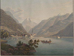
Flüelen was of the utmost importance for the Gotthard route in terms of transportation, as the flow of goods arriving by sea from Brunnen and Lucerne converged here. Shipping was almost exclusively in the hands of the shipping company, of which anyone wishing to transport passengers across the cantonal borders had to be a member. There were fixed tariffs imposed by the government for the transportation of passengers on the lake. For example, the journey from Flüelen to Lucerne in a large Nauen steered by 9 men cost 20 guilders [equivalent to around 570 Swiss francs in 2024]. This was probably only worthwhile if a large group of passengers could split the price. However, there was also a scheduled boat that sailed to Lucerne on Monday mornings and returned on Wednesdays. This scheduled boat was apparently quite popular; the description in the accompanying text to this view makes us think of today's commuter traffic on the train: "Travelers pay only 3 batzen [equivalent to about 5 Swiss francs in 2024] on the Nauen from Flüelen to Lucerne, but have to put up with being on the lake for 8-10 hours in a crowd of people, hearing many a joke, but also a lot of stupid things".

Ort auf moderner Karte
GEOMETRYCOLLECTION (POINT (8.621993 46.909585), LINESTRING (8.621993 46.909585, 8.62202 46.909461))
Camera Settings (3D)
{"landscape":{"image.scale":26,"viewpoint":{"bounds":[[8.598954551271788,46.910223930153336],[8.643243829684621,46.93289641454143]],"bearing":167.98881690695725,"pitch":84.99579828354959,"zoom":18.674322488471578,"center":{"lng":8.622227758169174,"lat":46.90889393727059},"cam":{"center":{"lng":8.630603894042196,"lat":46.92228266710637},"zoom":14.378920750131758,"bearing":0},"cameraToCenterDistance":1506.5675879442902,"cameraPosition":{"lngLat":{"lng":8.621702819103547,"lat":46.91057945613872},"altitude":450.27869183796327},"cameraTargetElevation":433.5},"camera.fov":46},"portrait":{"viewpoint":{"bounds":[[8.598954550499144,46.91022393015106],[8.643243830392692,46.93289641528932]],"bearing":167.98881690695725,"pitch":84.99579828354959,"zoom":18.674322488471578,"center":{"lng":8.622227758169743,"lat":46.9088939372682},"cameraToCenterDistance":1506.5675879442902,"cameraPosition":{"lngLat":{"lng":8.621702819104144,"lat":46.910579456136304},"altitude":450.278691837964},"cameraTargetElevation":433.5},"image.scale":25},"square":{"viewpoint":{"bounds":[[8.598954551275597,46.91022393015314],[8.643243829654097,46.932896414520656]],"bearing":167.98881690695725,"pitch":84.99579828354959,"zoom":18.674322488471578,"center":{"lng":8.62222775816997,"lat":46.90889393727048},"cam":{"center":{"lng":8.82040094316801,"lat":46.93668400217112},"zoom":9.988751795050888,"bearing":0},"cameraToCenterDistance":1506.5675879442902,"cameraPosition":{"lngLat":{"lng":8.621702819104371,"lat":46.91057945613858},"altitude":450.2786918379633},"cameraTargetElevation":433.5},"image.scale":25}}
Quellen

Karl Franz Lusser, Ansichten der St. Gotthards-Strasse von Flüelen bis Lugano, Zurich 1833, pp. 33-34

Bilder
nb-478523
Ort
GEOMETRYCOLLECTION (POINT (8.649931 46.878704), LINESTRING (8.649931 46.878704, 8.62298 46.89029))
Titel
View from Altdorf
Text

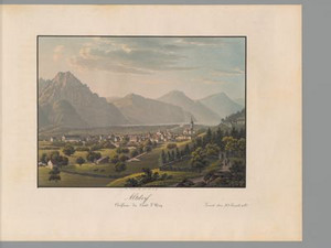
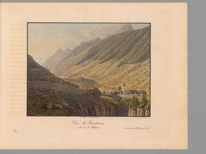
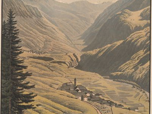
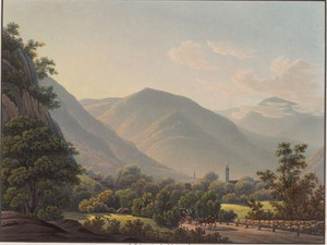
The view of Altdorf from the south-east shows the location of the village slightly elevated above the Reuss plain at the foot of the Hubel. From the village itself, we see the Capuchin convent of St. Charles on the left, past which the Gotthardstrasse runs, the parish church on the right and the Capuchin convent on the far right edge of the picture. In the foreground, Hellgass leads to Bürglen.
The last disaster had not been long ago at the time of this view: "In 1799. almost the whole of Altorf burned down, causing the unfortunate inhabitants a loss of 3. million Swiss francs (16. to a carolin) [about 33 million SFr. in 2024]."


Ort auf moderner Karte
GEOMETRYCOLLECTION (POINT (8.650298 46.879885), LINESTRING (8.650298 46.879885, 8.650175 46.879915))
Camera Settings (3D)
{"landscape":{"image.scale":54,"viewpoint":{"bounds":[[8.650587116715002,46.77631590302025],[8.77344857147358,46.879320483964335]],"bearing":-44.69060499308886,"pitch":83.26173467292689,"zoom":18.37854063326762,"center":{"lng":8.650073111057281,"lat":46.880151782914965},"cam":{"center":{"lng":8.769770922063515,"lat":46.83223315858842},"zoom":11.775736450064429,"bearing":0},"cameraToCenterDistance":1506.5675879442902,"cameraPosition":{"lngLat":{"lng":8.652244041843034,"lat":46.87865175979485},"altitude":526.865233376061},"cameraTargetElevation":499.1451782226563}},"portrait":{"image.scale":53,"viewpoint":{"bounds":[[8.650587116738649,46.776315910711276],[8.773448562287712,46.87932048396357]],"bearing":-44.69060499308886,"pitch":83.26173467292689,"zoom":18.37854063326762,"center":{"lng":8.650073111058077,"lat":46.88015178291357},"cameraToCenterDistance":1506.5675879442902,"cameraPosition":{"lngLat":{"lng":8.65224404184383,"lat":46.878651759793485},"altitude":526.8652333760617},"cameraTargetElevation":499.1451782226563}},"square":{"image.scale":55,"viewpoint":{"bounds":[[8.650587116600889,46.77631590678695],[8.77344856692332,46.879320483965415]],"bearing":-44.69060499308886,"pitch":83.26173467292689,"zoom":18.37854063326762,"center":{"lng":8.650073111055349,"lat":46.88015178291559},"cam":{"center":{"lng":9.264894368213021,"lat":46.86985689557139},"zoom":8.516748872356366,"bearing":0},"cameraToCenterDistance":1506.5675879442902,"cameraPosition":{"lngLat":{"lng":8.6522440418411,"lat":46.87865175979553},"altitude":526.8652333760607},"cameraTargetElevation":499.1451782226563}},"null":{"image.scale":85,"viewpoint":{"bounds":[[8.626315931351428,46.878332754293325],[8.652910771107344,46.90085262491655]],"bearing":-44.69060499324962,"pitch":79.52733958590194,"zoom":18.159965512565783,"center":{"lng":8.650298000010594,"lat":46.8798849999944},"cam":{"center":{"lng":8.64960769882012,"lat":46.88959387151846},"zoom":14.333741680051498,"bearing":0},"cameraToCenterDistance":1665}}}
Quellen

Johann Gottfried Ebel, Anleitung, auf die nützlichste und genussvollste Art die Schweitz zu bereisen, vol. 2, Zurich 1809, p. 66


Bilder
nb-478524
Ort
GEOMETRYCOLLECTION (POINT (8.668427 46.765001), LINESTRING (8.668427 46.765001, 8.670015 46.766882))
Titel
View from Amsteg
Text

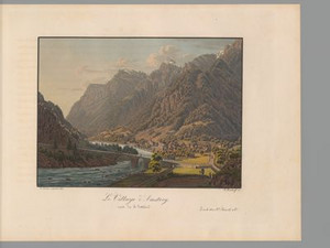
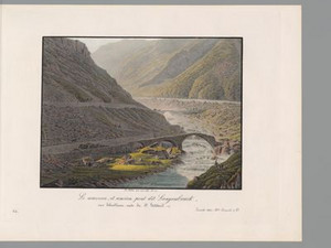
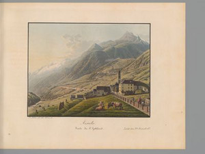
Amsteg lies on the Gotthard transit axis in the canton of Uri. Like all villages on this Alpine crossing, Amsteg was primarily a mule village. 
Goethe stayed at the "Stern und Post" hotel, which opened in 1788. The hotel is considered to be one of the first post offices in Switzerland and was first mentioned in a document in 1357, making it one of the oldest inns in Central Switzerland.


Ort auf moderner Karte
GEOMETRYCOLLECTION (POINT (8.667414 46.765758), LINESTRING (8.667414 46.765758, 8.667494 46.765821))
Camera Settings (3D)
{"landscape":{"image.scale":304,"viewpoint":{"bounds":[[8.120890066182028,46.47011955207665],[8.6675034065957,46.80091286560048]],"bearing":42.78611546749095,"pitch":81.99999999999999,"zoom":15.552676509399992,"center":{"lng":8.673078417778129,"lat":46.76938789957205},"cam":{"center":{"lng":8.57900805778965,"lat":46.649866877567774},"zoom":10.097653054799094,"bearing":0},"cameraToCenterDistance":1130.312423387329,"cameraPosition":{"lngLat":{"lng":8.661955981171502,"lat":46.76115640333268},"altitude":722.6482183417404},"cameraTargetElevation":547.3812499998494},"camera.fov":59},"portrait":{"image.scale":259,"viewpoint":{"bounds":[[8.11118905650855,46.46502735022622],[8.66719836308485,46.80152069779999]],"bearing":42.78611546749095,"pitch":81.99999999999999,"zoom":15.5280881482816,"center":{"lng":8.672869205474854,"lat":46.76945403667119},"cameraToCenterDistance":1130.312423387329,"cameraPosition":{"lngLat":{"lng":8.661555580636474,"lat":46.76108104507185},"altitude":722.6482369226771},"cameraTargetElevation":544.3687500000651}},"square":{"image.scale":315,"viewpoint":{"bounds":[[8.111189056521766,46.465027350210136],[8.667198363085589,46.8015206977752]],"bearing":42.78611546749095,"pitch":81.99999999999999,"zoom":15.5280881482816,"center":{"lng":8.672869205475536,"lat":46.76945403667045},"cam":{"center":{"lng":10.89123558934071,"lat":46.824094182447595},"zoom":6.3386721600289295,"bearing":0},"cameraToCenterDistance":1130.312423387329,"cameraPosition":{"lngLat":{"lng":8.661555580637241,"lat":46.76108104507108},"altitude":722.6482369226796},"cameraTargetElevation":544.3687500000651}}}
Quellen

Ansichten der neuen St. Gotthards-Strasse von Fluelen bis Lugano 1833, Ansicht von Amsteg; https://schweizmobil.ch/de/ort-4-amsteg [7.06.2023]; https://denkmalpflege-schweiz.ch/2014/11/04/wo-einst-die-gotthardpost-stoppte-swiss-historic-hotel-stern-und-post-in-amsteg/ [7.06.2023]

Bilder
nb-478525
Ort
GEOMETRYCOLLECTION (POINT (8.614011 46.71668), LINESTRING (8.614011 46.71668, 8.602166 46.707293))
Titel
The Pfaffensprung bridge and view of Wassen
Text

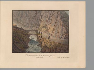
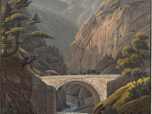
The Pfaffensprung Bridge is so named "[...] because according to an old folk tale, a monk fleeing with a girl is said to have dared the dangerous leap over the Reuss here. The bridge is short and was extended in 1821 and fitted with very beautiful railings hewn from gneiss, the arch of which is 90 feet [around 30m] above the water, which squeezes through the narrow, bare rocky gorge, shaded at the top by bushes, deep in the shade."
The church of Wassen in the background became famous after the opening of the Gotthard Railway in 1882 because it can be seen from the railroad line three times from different angles.


Ort auf moderner Karte
GEOMETRYCOLLECTION (POINT (8.613517 46.717151), LINESTRING (8.613517 46.717151, 8.611178 46.715334))
Camera Settings (3D)
{"landscape":{"image.scale":112,"viewpoint":{"bounds":[[8.614312531287794,46.70756118011744],[8.711146591132746,46.769963379358785]],"bearing":-133.46221537302318,"pitch":85,"zoom":16.29713559764467,"center":{"lng":8.609418869034016,"lat":46.71439621597557},"cam":{"center":{"lng":8.697659671207674,"lat":46.74143107518188},"zoom":12.501163101657507,"bearing":0},"cameraToCenterDistance":1130.312423387329,"cameraPosition":{"lngLat":{"lng":8.616555322231562,"lat":46.71903317678181},"altitude":892.8843069760247},"cameraTargetElevation":827.3031249135765}},"portrait":{"image.scale":129,"viewpoint":{"bounds":[[8.614310318473542,46.707536274860416],[8.711354322222832,46.7700752156606]],"bearing":-133.46221537278404,"pitch":84.9941797057601,"zoom":16.297122768350274,"center":{"lng":8.609418869036176,"lat":46.71439621597614},"cameraToCenterDistance":1130.312423387329,"cameraPosition":{"lngLat":{"lng":8.616555322233722,"lat":46.719033176782375},"altitude":892.9610369722011},"cameraTargetElevation":827.3031249135765}},"square":{"image.scale":136,"viewpoint":{"bounds":[[8.61431253128697,46.707561180117835],[8.711146591092813,46.7699633793346]],"bearing":-133.46221537302318,"pitch":85,"zoom":16.29713559764467,"center":{"lng":8.609418869033334,"lat":46.714396215975256},"cam":{"center":{"lng":9.098482830316215,"lat":46.771942533616084},"zoom":8.860194704820916,"bearing":0},"cameraToCenterDistance":1130.312423387329,"cameraPosition":{"lngLat":{"lng":8.616555322230852,"lat":46.719033176781494},"altitude":892.8843069760251},"cameraTargetElevation":827.3031249135765}}}
Quellen

Karl Franz Lusser, accompanying text to the work Ansichten der St. Gotthards-Strasse von Flüelen bis Lugano, Zurich 1833, p. 50

Bilder
nb-478526
Ort
GEOMETRYCOLLECTION (POINT (8.590107 46.668022), LINESTRING (8.590107 46.668022, 8.584228 46.666958))
Titel
View from Göschenen
Text

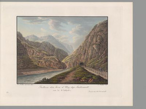
Göschenen, then still called Göschinen, is located in the canton of Uri. In 1833, this village was mainly inhabited by mule drivers who made a living from the goods transported through Göschenen. Until the opening of the road in 1830 and the Gotthard Railway in 1882, crystals were also traded here. Göschenen developed into a lively center for carters and coachmen until the opening of the Schöllenen Railway in 1917. In the 1900s, Göschenen was particularly active in the granite industry, a rock from the Gotthard.


Ort auf moderner Karte
GEOMETRYCOLLECTION (POINT (8.588851 46.66786), LINESTRING (8.588851 46.66786, 8.580923 46.667164))
Camera Settings (3D)
{"landscape":{"image.scale":114,"viewpoint":{"bounds":[[8.591985876289925,46.622589428838126],[8.64902716912897,46.70054577523089]],"bearing":-93.28437261949665,"pitch":84.99874366477941,"zoom":16.43873615486352,"center":{"lng":8.584372401231121,"lat":46.6681950443882},"cam":{"center":{"lng":8.664080845782024,"lat":46.664904364665006},"zoom":12.182156035299366,"bearing":0},"cameraToCenterDistance":1130.312423387329,"cameraPosition":{"lngLat":{"lng":8.593270717473104,"lat":46.66854545484563},"altitude":1158.9893168305537},"cameraTargetElevation":1099.4733398559383},"camera.fov":59},"portrait":{"image.scale":93,"viewpoint":{"bounds":[[8.592189508323088,46.64038418337526],[8.622445268015952,46.6821070592876]],"bearing":-85.28437261967595,"pitch":84.5,"zoom":17.60683220458377,"center":{"lng":8.588851000007708,"lat":46.66786000000201},"cameraToCenterDistance":1130.312423387329,"cameraPosition":{"lngLat":{"lng":8.592800751903724,"lat":46.66763641781279},"altitude":1128.5920638851305},"cameraTargetElevation":1099.4733398559383}},"square":{"image.scale":93,"viewpoint":{"bounds":[[8.592189508320416,46.640384183375005],[8.622445268018112,46.68210705928834]],"bearing":-85.28437261967595,"pitch":84.5,"zoom":17.60683220458377,"center":{"lng":8.588851000005093,"lat":46.66786000000246},"cam":{"center":{"lng":8.743468306808893,"lat":46.67163107049794},"zoom":10.538499476069669,"bearing":0},"cameraToCenterDistance":1130.312423387329,"cameraPosition":{"lngLat":{"lng":8.592800751901052,"lat":46.667636417813185},"altitude":1128.5920638851303},"cameraTargetElevation":1099.4733398559383}}}
Quellen

Ansichten der St. Gotthards-Strasse von Flüelen bis Lugano, Ansicht von Göschenen; Hans Stadler, "Göschenen", in: Historical Dictionary of Switzerland (HLS), version of 14.09.2005 [07.06.2023]; https://www.myswitzerland.com/de-ch/erlebnisse/goescheneralp-sanfter-tourismus-in-hartem-granit/ [7.06.2023]

Bilder
nb-478527
Ort
GEOMETRYCOLLECTION (POINT (8.584142 46.658862), LINESTRING (8.584142 46.658862, 8.583283 46.655725))
Titel
The Häderlis Bridge
Text

The Häderlis Bridge was built in 1649 to replace an older footbridge. On the night of August 24-25, 1987, a flood destroyed the historic bridge. In 1991, the canton of Uri built an identical stone arch bridge on the site with the help of the federal government and the Swiss Association of Master Builders.


Ort auf moderner Karte
GEOMETRYCOLLECTION (POINT (8.584142 46.658862), LINESTRING (8.584142 46.658862, 8.583004 46.656035))
Camera Settings (3D)
{"landscape":{"image.scale":44,"camera.fov":55,"viewpoint":{"bounds":[[8.576941729117152,46.66005303181072],[8.616458278748723,46.677756864731634]],"bearing":-159.4383998759912,"pitch":85,"zoom":18.10142007749118,"center":{"lng":8.5837246477613,"lat":46.65845651812003},"cam":{"center":{"lng":8.60659704376718,"lat":46.66966027666797},"zoom":14.32056529715052,"bearing":0},"cameraToCenterDistance":1228.4680701980606,"cameraPosition":{"lngLat":{"lng":8.584799236588225,"lat":46.660422674777266},"altitude":1217.1580462700715},"cameraTargetElevation":1196.7288818359377}},"portrait":{"image.scale":42,"viewpoint":{"bounds":[[8.576941729098962,46.66005303181055],[8.616458278790446,46.67775686475423]],"bearing":-159.4383998759912,"pitch":85,"zoom":18.10142007749118,"center":{"lng":8.583724647760391,"lat":46.65845651811986},"cameraToCenterDistance":1228.4680701980606,"cameraPosition":{"lngLat":{"lng":8.584799236587344,"lat":46.66042267477707},"altitude":1217.1580462700715},"cameraTargetElevation":1196.7288818359377}},"square":{"image.scale":171,"viewpoint":{"bounds":[[8.525383879302666,46.61963453084908],[8.594680297748909,46.66282112094041]],"bearing":-161.03839987599133,"pitch":78.99999999999999,"zoom":16.77748149512196,"center":{"lng":8.584983944869123,"lat":46.65831752825372},"cam":{"center":{"lng":8.577356193137348,"lat":46.64123213492417},"zoom":13.121005626385287,"bearing":0},"cameraToCenterDistance":1387.4959775696843,"cameraPosition":{"lngLat":{"lng":8.58775395492998,"lat":46.66385074595061},"altitude":1302.9091332850242},"cameraTargetElevation":1176.4449212089637},"camera.fov":50}}
Quellen

Page "Häderlisbrücke". In: Wikipedia - The free encyclopedia. Edit status: July 9, 2022, 15:04 UTC [21/06/2024]

Bilder
nb-478528
Ort
GEOMETRYCOLLECTION (POINT (8.590922 46.648022), LINESTRING (8.590922 46.648022, 8.588948 46.646961))
Titel
View of the old and new Devil's Bridge
Text

The accompanying text informs us that the arch of the Teufelsbrücke (Devil's Bridge) of 1830 "[...] is 55 feet in the light and 21 feet high, and its center is raised 95 feet above the Reuss foaming below; it proudly looks down on the still standing old Teufelsbrücke, which stands 75 feet above the Reuss, as a telling witness that today people are capable of creating something more gigantic than what the superstition of older times considered possible only with the help of the evil spirit." According to Lusser's description, the bold structure was around 40 meters high. However, the Inventory of Historic Traffic Routes in Switzerland (IVS) gives the much lower figure of 15 m high. Did Lusser exaggerate?

In the last sentence, the text refers to the legend that when the first bridge was built in the Schöllenen in the deep Middle Ages, the desperate people of Uri called on the devil to build them a bridge in this impossible place. The devil agreed on the condition that the first soul to cross the new bridge would belong to him. However, the people of Uri first drove a billy goat across the bridge, which the devil then had to make do with. The most recent Devil's Bridge was built in 1955/56, while the bridge from 1830 is now only used by pedestrians.


Ort auf moderner Karte
GEOMETRYCOLLECTION (POINT (8.590284 46.647342), LINESTRING (8.590284 46.647342, 8.590171 46.647338))
Camera Settings (3D)
{"landscape":{"image.scale":86,"camera.fov":56,"viewpoint":{"bounds":[[8.523580245699605,46.610642290663606],[8.592964277723041,46.68229053492962]],"bearing":-105.0813286831467,"pitch":70.5272734216398,"zoom":17.72752059063131,"center":{"lng":8.590283999997723,"lat":46.64734200000177},"cam":{"center":{"lng":8.598309437579843,"lat":46.649532126393524},"zoom":12.304294074216315,"bearing":0},"cameraToCenterDistance":1202.7245745889793,"cameraPosition":{"lngLat":{"lng":8.59383116270405,"lat":46.64799818002223},"altitude":1524.4429655109855},"cameraTargetElevation":1425.2885288084312}},"portrait":{"image.scale":99,"viewpoint":{"bounds":[[8.523580245648446,46.61064229062865],[8.592964277723524,46.68229053496128]],"bearing":-105.0813286831467,"pitch":70.5272734216398,"zoom":17.72752059063131,"center":{"lng":8.59028399999761,"lat":46.64734200000183},"cameraToCenterDistance":1202.7245745889793,"cameraPosition":{"lngLat":{"lng":8.593831162704134,"lat":46.64799818002214},"altitude":1524.4429655109852},"cameraTargetElevation":1425.2885288084312}},"square":{"image.scale":86,"viewpoint":{"bounds":[[8.529575035075226,46.61598447657059],[8.593138007152362,46.67518650307835]],"bearing":-105.0813286831467,"pitch":68.11199644777739,"zoom":17.704560015899943,"center":{"lng":8.590283999998292,"lat":46.647342000002055},"cam":{"center":{"lng":8.847389895460992,"lat":46.66740746860398},"zoom":9.467522702312886,"bearing":0},"cameraToCenterDistance":1371.4121756658628,"cameraPosition":{"lngLat":{"lng":8.59432866843457,"lat":46.64809021162324},"altitude":1553.7530191661242},"cameraTargetElevation":1425.2885288084312},"camera.fov":50}}
Quellen

Karl Franz Lusser, accompanying text to the work Ansichten der St. Gotthards-Strasse von Flüelen bis Lugano, Zurich 1833, p. 55; Federal Inventory of Historic Transport Routes in Switzerland (IVS), UR 1.3.2 (PDF) [19.04.2024]

Bilder
nb-478529
Ort
GEOMETRYCOLLECTION (POINT (8.590837 46.645135), LINESTRING (8.590837 46.645135, 8.592725 46.641192))
Titel
View from the Urnerloch towards Andermatt
Text

This tunnel was one of the first to be built in the Gotthard region. With a length of 64m, it was the longest tunnel in Switzerland in 1833 and made it possible to avoid dangerous passages. The angle chosen by the artist allows the viewer to see the ingenuity of the construction and the Gotthard massif in the background.


Ort auf moderner Karte
GEOMETRYCOLLECTION (POINT (8.591159 46.645168), LINESTRING (8.591159 46.645168, 8.592167 46.641079))
Camera Settings (3D)
{"landscape":{"viewpoint":{"bounds":[[8.26711457194449,46.33410380782709],[8.922582283041237,46.64573200267296]],"bearing":167.6837800863084,"pitch":80.52705628306515,"zoom":17.973122926278077,"center":{"lng":8.591568768025468,"lat":46.64377592577034},"cam":{"center":{"lng":8.768485653591028,"lat":46.503422315789265},"zoom":10.187629912216783,"bearing":0},"cameraToCenterDistance":1371.4121756658628,"cameraPosition":{"lngLat":{"lng":8.590780283028664,"lat":46.64625521579174},"altitude":1488.7703455088981},"cameraTargetElevation":1441.6856444924451}},"portrait":{"viewpoint":{"bounds":[[8.267114556317352,46.334103792600416],[8.92258229915015,46.64573200267404]],"bearing":167.6837800863084,"pitch":80.52705628306515,"zoom":17.973122926278077,"center":{"lng":8.591568768026036,"lat":46.643775925771536},"cameraToCenterDistance":1371.4121756658628,"cameraPosition":{"lngLat":{"lng":8.590780283029147,"lat":46.64625521579296},"altitude":1488.770345508897},"cameraTargetElevation":1441.6856444924451}},"square":{"viewpoint":{"bounds":[[8.26711457408851,46.33410380977449],[8.922582281019942,46.64573200267168]],"bearing":167.6837800863084,"pitch":80.52705628306515,"zoom":17.973122926278077,"center":{"lng":8.591568768024217,"lat":46.643775925769376},"cam":{"center":{"lng":11.5444531087455,"lat":46.71531112717375},"zoom":6.101256486586258,"bearing":0},"cameraToCenterDistance":1371.4121756658628,"cameraPosition":{"lngLat":{"lng":8.590780283027271,"lat":46.646255215790745},"altitude":1488.7703455088988},"cameraTargetElevation":1441.6856444924451}}}
Quellen

Ansichten der neuen St. Gotthards-Strasse von Fluelen bis Lugano 1833, Ansicht aus dem Urnerloch Richtung Andermatt; https://www.nb.admin.ch/snl/de/home/publikationen-forschung/thematische-dossiers/gotthard-ansichten/urnerloch.html [08.06.2023]

Bilder
nb-478530
Ort
GEOMETRYCOLLECTION (POINT (8.592896 46.641265), LINESTRING (8.592896 46.641265, 8.590322 46.64484))
Titel
View back to the Urnerloch in the direction of the Schöllenen Gorge
Text

The Urnerloch is a tunnel in the canton of Uri on the Gotthard route. It is the first road tunnel to be built through the Alps. Pietro Morettini, a Swiss engineer who was also in the service of King Louis XIV, began construction in 1707 and bored the tunnel using black powder.


Ort auf moderner Karte
GEOMETRYCOLLECTION (POINT (8.591952 46.642552), LINESTRING (8.591952 46.642552, 8.591459 46.643699))
Camera Settings (3D)
{"landscape":{"camera.fov":52,"image.scale":50,"viewpoint":{"bounds":[[8.40405071955118,46.47431584661996],[8.773868382482078,46.64122345711323]],"bearing":-11.267548603193745,"pitch":81.52749909014061,"zoom":18.35812544034366,"center":{"lng":8.591960370540619,"lat":46.64253203036529},"cam":{"center":{"lng":8.682075361229664,"lat":46.56494763662627},"zoom":11.08660814254023,"bearing":0},"cameraToCenterDistance":1311.1693066899602,"cameraPosition":{"lngLat":{"lng":8.592490623569944,"lat":46.64070475108491},"altitude":1463.6085869085339},"cameraTargetElevation":1432.747839355469}},"portrait":{"image.scale":80,"viewpoint":{"bounds":[[8.268044465701735,46.35226567106747],[8.90551426444324,46.64029633991544]],"bearing":-11.267548603193745,"pitch":81.52749909014061,"zoom":17.572582541832674,"center":{"lng":8.591952000009883,"lat":46.642552000003064},"cameraToCenterDistance":1311.1693066899602,"cameraPosition":{"lngLat":{"lng":8.592866018820303,"lat":46.639402206719325},"altitude":1485.9437511194024},"cameraTargetElevation":1432.747839355469}},"square":{"image.scale":92,"viewpoint":{"bounds":[[8.268044459513277,46.35226566566237],[8.905514270205401,46.640296339916404]],"bearing":-11.267548603193745,"pitch":81.52749909014061,"zoom":17.572582541832674,"center":{"lng":8.591952000008405,"lat":46.64255200000406},"cam":{"center":{"lng":11.455393512973785,"lat":46.715445962001326},"zoom":6.141424170808022,"bearing":0},"cameraToCenterDistance":1311.1693066899602,"cameraPosition":{"lngLat":{"lng":8.592866018818881,"lat":46.63940220672029},"altitude":1485.9437511194014},"cameraTargetElevation":1432.747839355469}}}
Quellen

Ansichten der neuen St. Gotthards-Strasse von Fluelen bis Lugano 1833, Blick zurück aufs Urnerloch Richtung Schöllenenschlucht;  Hans Stadler, "Schöllenen", in: Historisches Lexikon der Schweiz (HLS), version of 11.04.2011 [12.06.2023]; https://www.letemps.ch/societe/premier-trou-alpes [12.06.2023]

Bilder
nb-478531
Ort
POINT (8.596802 46.636237)
Titel
View from Andermatt towards Hospental with the Furka in the background
Text

After passing the fearsome Schöllenen, we reach the Urseren Valley, first Andermatt: "A pretty parish village of about 80 houses, several of which are tastefully built of stone. It has a beautiful, spacious church, and on a hill above the village there is a very nice chapel. This village, which lies [...] in a beautiful plain at the foot of the Gurschen, is inhabited by 618 people." Its inhabitants lived to a large extent from cheese and wine shipping, for which the village was very suitable due to its location at the intersection of three important Alpine passes (in addition to the Gotthard, the Furka and the Oberalp Pass). The Urseren Valley was also famous for its own cheese, which was exported in large quantities. In Andermatt, you could also buy magnificent rock crystals and fossils from the surrounding mountains.


Aufnahmestandort
nb-478531
Ort auf moderner Karte
GEOMETRYCOLLECTION (POINT (8.599897 46.637127), LINESTRING (8.599897 46.637127, 8.58882 46.630579))
Camera Settings (3D)
{"landscape":{"camera.fov":60,"image.scale":19,"viewpoint":{"bounds":[[8.397751317493032,46.52695792272792],[8.60001642165409,46.68194938822771]],"bearing":-125.5691957851735,"pitch":75.52715322674477,"zoom":17.341488373272608,"center":{"lng":8.596581816673279,"lat":46.63550546385207},"cam":{"center":{"lng":8.585426273015855,"lat":46.611115043715046},"zoom":11.192227099925734,"bearing":0},"cameraToCenterDistance":1107.646491440297,"cameraPosition":{"lngLat":{"lng":8.600275262640793,"lat":46.63731901051071},"altitude":1536.1405079036135},"cameraTargetElevation":1446.6573242042944}},"portrait":{"camera.fov":58,"viewpoint":{"bounds":[[8.37084215978902,46.51249924897252],[8.60012827878569,46.68492894465385]],"bearing":-125.5691957851735,"pitch":76.52715322674477,"zoom":17.341488373272608,"center":{"lng":8.596581816678736,"lat":46.63550546385204},"cameraToCenterDistance":1153.6885394960755,"cameraPosition":{"lngLat":{"lng":8.600445533258721,"lat":46.63740261489798},"altitude":1533.543937464036},"cameraTargetElevation":1446.6573242042944},"image.scale":16},"square":{"image.scale":19,"viewpoint":{"bounds":[[8.370842159863315,46.512499249007675],[8.60012827878603,46.68492894462776]],"bearing":-125.5691957851735,"pitch":76.52715322674477,"zoom":17.341488373272608,"center":{"lng":8.596581816678963,"lat":46.63550546385105},"cam":{"center":{"lng":9.517272754476807,"lat":46.67749701585592},"zoom":7.616632175014321,"bearing":0},"cameraToCenterDistance":1153.6885394960755,"cameraPosition":{"lngLat":{"lng":8.600445533259006,"lat":46.637402614896956},"altitude":1533.5439374640378},"cameraTargetElevation":1446.6573242042944}}}
Quellen

Karl Franz Lusser,  accompanying text to the work Ansichten der St. Gotthards-Strasse von Flüelen bis Lugano, Zurich 1833, pp. 63-68; Johann Gottfried Ebel, Anleitung, auf die nützlichste und genussvollste Art die Schweitz zu bereisen, vol. 2, Zurich 1809, pp. 87-90

Bilder
nb-478532
Ort
GEOMETRYCOLLECTION (POINT (8.569679 46.622945), LINESTRING (8.569679 46.622945, 8.565044 46.617403))
Titel
View of the village of Hospenthal
Text

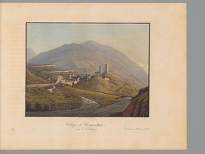
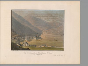
"A village of 31 houses, 2 inns, one of which The Golden Lion is particularly recommended, a beautiful church and cute chapel, dedicated to St. Carolus. It lies 4550 to 4560 feet above sea level and is inhabited by about 400 souls".
The second village in the Urseren Valley, Hospental, lies at the foot of the actual Gotthard Pass route. The road to the Furka Pass also branches off to the left. Next to the village, the tower dominating the village rises on a hill, which was built in the 13th century by the von Hospental family, who controlled the pass traffic from there.


Ort auf moderner Karte
GEOMETRYCOLLECTION (POINT (8.571289 46.622694), LINESTRING (8.571289 46.622694, 8.56689 46.617507))
Camera Settings (3D)
{"landscape":{"image.scale":78,"camera.fov":58,"viewpoint":{"bounds":[[8.555321695510486,46.623312704090694],[9.031866981279222,46.870467806659235]],"bearing":-143.45806053667252,"pitch":80.52709664541328,"zoom":17.474531799559507,"center":{"lng":8.570247888565063,"lat":46.6217848695448},"cam":{"center":{"lng":8.931962490794575,"lat":46.75756562652202},"zoom":10.515194270365436,"bearing":0},"cameraToCenterDistance":1153.6885394960755,"cameraPosition":{"lngLat":{"lng":8.572863762315308,"lat":46.624209083016126},"altitude":1508.1713661476515},"cameraTargetElevation":1452.1871093928164}},"portrait":{"image.scale":79,"viewpoint":{"bounds":[[8.555321695530068,46.623312704091035],[9.031866980667388,46.87046780635242]],"bearing":-143.45806053667252,"pitch":80.52709664541328,"zoom":17.474531799559507,"center":{"lng":8.570247888564609,"lat":46.621784869545195},"cameraToCenterDistance":1153.6885394960755,"cameraPosition":{"lngLat":{"lng":8.572863762314967,"lat":46.624209083016524},"altitude":1508.171366147651},"cameraTargetElevation":1452.1871093928164}},"square":{"image.scale":83,"viewpoint":{"bounds":[[8.555321695490335,46.62331270409095],[9.031866980668667,46.87046780639696]],"bearing":-143.45806053667252,"pitch":80.52709664541328,"zoom":17.474531799559507,"center":{"lng":8.570247888564154,"lat":46.621784869545195},"cam":{"center":{"lng":10.938048121381996,"lat":46.91005402771631},"zoom":6.56116787404324,"bearing":0},"cameraToCenterDistance":1153.6885394960755,"cameraPosition":{"lngLat":{"lng":8.572863762314341,"lat":46.62420908301655},"altitude":1508.171366147651},"cameraTargetElevation":1452.1871093928164}}}
Quellen

Hans Stadler, "Hospental", in: Historical Dictionary of Switzerland (HLS), version of 16.02.2023 [22.04.2024]; Karl Franz Lusser, accompanying text to the work Ansichten der St. Gotthards-Strasse von Flüelen bis Lugano, Zurich 1833, p. 69

Bilder
nb-478533
Ort
GEOMETRYCOLLECTION (POINT (8.56582 46.557621), LINESTRING (8.56582 46.557621, 8.572855 46.551584))
Titel
View from the St. Gotthard Hospice
Text

Even before the Schöllenen Gorge was made passable around 1200, there was a chapel dedicated to St. Gotthard at the top of the pass. With the increase in pass traffic, a hospice developed, which was destroyed by an avalanche in 1774 or 1775. Finally, in 1777, a more spacious hospital was built with an eye-catching octagonal stable that could accommodate 47 animals at a time. It was razed to the ground in 1799 during the Napoleonic Wars and never rebuilt. Shortly after this view was created, a hospice was opened in 1837, adapted to the increased needs.


Ort auf moderner Karte
GEOMETRYCOLLECTION (POINT (8.565123 46.557717), LINESTRING (8.565123 46.557717, 8.572512 46.552115))
Camera Settings (3D)
{"landscape":{"camera.fov":60,"image.scale":44,"viewpoint":{"bounds":[[8.354473559393426,46.55766137654027],[8.59140296919071,46.742678162658734]],"bearing":132.09797533567644,"pitch":80.52712779450235,"zoom":17.70988903572685,"center":{"lng":8.566385507584982,"lat":46.55695878501163},"cam":{"center":{"lng":8.576333200755045,"lat":46.658134468292644},"zoom":10.93554065805678,"bearing":0},"cameraToCenterDistance":1107.646491440297,"cameraPosition":{"lngLat":{"lng":8.56372682445297,"lat":46.55861054672292},"altitude":2144.9543836941375},"cameraTargetElevation":2099.240624999942}},"portrait":{"image.scale":44,"viewpoint":{"bounds":[[8.354473552529925,46.55766137654106],[8.591402968988518,46.742678161496]],"bearing":132.09797533567644,"pitch":80.52712779450235,"zoom":17.70988903572685,"center":{"lng":8.566385507583732,"lat":46.55695878501254},"cameraToCenterDistance":1107.646491440297,"cameraPosition":{"lngLat":{"lng":8.563726824451692,"lat":46.558610546723855},"altitude":2144.954383694137},"cameraTargetElevation":2099.240624999942}},"square":{"image.scale":44,"viewpoint":{"bounds":[[8.354473559031447,46.557661376540864],[8.591402968127738,46.74267815576022]],"bearing":132.09797533567644,"pitch":80.52712779450235,"zoom":17.70988903572685,"center":{"lng":8.566385507584073,"lat":46.55695878501243},"cam":{"center":{"lng":9.539120604513045,"lat":46.731507848888896},"zoom":7.569323905580709,"bearing":0},"cameraToCenterDistance":1107.646491440297,"cameraPosition":{"lngLat":{"lng":8.563726824452004,"lat":46.55861054672371},"altitude":2144.954383694137},"cameraTargetElevation":2099.240624999942}}}
Quellen

Johann Gottfried Ebel, Anleitung, auf nützlichste und genussvollste Art die Schweitz zu bereisen, vol. 3, Zurich 1810, pp. 127-128; Bundesinventar der historischen Verkehrswege der Schweiz (IVS), TI 6.1.7 (PDF) [08.12.2023]; HLS DHS DSS, "Gotthardpass", in: Historisches Lexikon der Schweiz (HLS), version of 30.08.2016, translated from Italian [08.12.2023]; Federal Inventory of Historic Transport Routes in Switzerland (IVS), TI 6.2.3 (PDF) [22.04.2024]; Karl Franz Lusser, accompanying text to the work Ansichten der St. Gotthards-Strasse von Flüelen bis Lugano, Zurich 1833, pp. 71-72

Bilder
nb-478534
Ort
GEOMETRYCOLLECTION (POINT (8.574408 46.541123), LINESTRING (8.574408 46.541123, 8.566418 46.546108))
Titel
View of the Tremola Bridge. Road to S. Gotthard
Text

The Tremola road is still the longest road monument in Switzerland today. On the Ticino side, this road was built between 1827-1830 by Francesco Meschini, an Italian architect, and connects Göschenen with Airolo. The road has 24 bends - and each one has a name! Today, this road has become historic, motorcycles and cyclists have replaced the carriages, but the cobblestones remain.


Ort auf moderner Karte
GEOMETRYCOLLECTION (POINT (8.574 46.541064), LINESTRING (8.574 46.541064, 8.567276 46.547938))
Camera Settings (3D)
{"landscape":{"image.scale":121,"viewpoint":{"bounds":[[8.576179369168415,46.36952078354054],[8.767373680840791,46.56677418757096]],"bearing":-61.00633399580937,"pitch":81.02746099228746,"zoom":17.30945873626474,"center":{"lng":8.573332428944127,"lat":46.54173501678642},"cam":{"center":{"lng":8.781640625461478,"lat":46.47664392410729},"zoom":10.847986148990854,"bearing":0},"cameraToCenterDistance":1107.646491440297,"cameraPosition":{"lngLat":{"lng":8.57747496349694,"lat":46.54015598892897},"altitude":1800.0024355996898},"cameraTargetElevation":1742.8087888743744}},"portrait":{"image.scale":127,"viewpoint":{"bounds":[[8.576317445869591,46.280305617115374],[8.873557947311923,46.575190002717136]],"bearing":-61.00633399580937,"pitch":81.02746099228746,"zoom":17.30945873626474,"center":{"lng":8.573332428946173,"lat":46.54173501678554},"cameraToCenterDistance":1177.8124816183965,"cameraPosition":{"lngLat":{"lng":8.5777373802907,"lat":46.54005596083505},"altitude":1803.6254767824062},"cameraTargetElevation":1742.8087888743744},"camera.fov":57},"square":{"image.scale":148,"viewpoint":{"bounds":[[8.576317445870046,46.280305617134246],[8.873557947360695,46.575190002685474]],"bearing":-61.00633399580937,"pitch":81.02746099228746,"zoom":17.30945873626474,"center":{"lng":8.573332428946856,"lat":46.54173501678568},"cam":{"center":{"lng":10.062519953323061,"lat":46.53028988827734},"zoom":7.242150482747712,"bearing":0},"cameraToCenterDistance":1177.8124816183965,"cameraPosition":{"lngLat":{"lng":8.577737380291353,"lat":46.54005596083522},"altitude":1803.625476782406},"cameraTargetElevation":1742.8087888743744}}}
Bilder
nb-478535
Ort
POINT (8.591574 46.530701)
Titel
View of the Tremola Valley road via Airolo, Stalvedro, Piotta and Ambri
Text

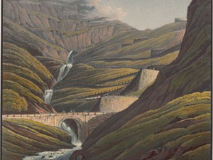
This view shows the two different generations of the Gotthard road. In addition to the new, six-metre-wide road, the old mule track is also depicted, which was only about two and a half meters wide - just wide enough for two fully loaded mules or horses to cross.


Aufnahmestandort
nb-478535
Ort auf moderner Karte
GEOMETRYCOLLECTION (POINT (8.591467 46.531469), LINESTRING (8.591467 46.531469, 8.591614 46.531436))
Camera Settings (3D)
{"landscape":{"image.scale":293,"camera.fov":51,"viewpoint":{"bounds":[[8.588894761631536,46.0218959695857],[9.228609912467078,46.766995306020675]],"bearing":97.11931897694899,"pitch":77.35259578822537,"zoom":15.171728325613453,"center":{"lng":8.607466220857305,"lat":46.5306276240313},"cam":{"center":{"lng":9.323197722741781,"lat":46.42746719052951},"zoom":8.932524192221441,"bearing":0},"cameraToCenterDistance":1340.7396316168877,"cameraPosition":{"lngLat":{"lng":8.582737441266005,"lat":46.532752436553636},"altitude":1740.1948787643641},"cameraTargetElevation":1312.4046874999112}},"portrait":{"image.scale":276,"viewpoint":{"bounds":[[8.588894761629206,46.0218959704616],[9.228609911402913,46.76699530565352]],"bearing":97.11931897694899,"pitch":77.35259578822537,"zoom":15.171728325613453,"center":{"lng":8.607466220855144,"lat":46.53062762403104},"cameraToCenterDistance":1340.7396316168877,"cameraPosition":{"lngLat":{"lng":8.582737441263788,"lat":46.53275243655338},"altitude":1740.1948787643664},"cameraTargetElevation":1312.4046874999112}},"square":{"image.scale":295,"viewpoint":{"bounds":[[8.588894761627529,46.02189596944402],[9.228609912680213,46.76699530612257]],"bearing":97.11931897694899,"pitch":77.35259578822537,"zoom":15.171728325613453,"center":{"lng":8.607466220852984,"lat":46.530627624031126},"cam":{"center":{"lng":11.787470516890977,"lat":46.61586884250275},"zoom":6.136351538671528,"bearing":0},"cameraToCenterDistance":1340.7396316168877,"cameraPosition":{"lngLat":{"lng":8.582737441261685,"lat":46.532752436553466},"altitude":1740.1948787643657},"cameraTargetElevation":1312.4046874999112}}}
Bilder
nb-478536
Ort
GEOMETRYCOLLECTION (POINT (8.613973 46.528487), LINESTRING (8.613973 46.528487, 8.588991 46.527277))
Titel
View from Airolo
Text

Here, too, we see the rescana, racks for drying rye. In the background, the Gotthard road stretches up the mountainside, in the shadows we can still make out the hairpin bends in the Tremola.

Ort auf moderner Karte
GEOMETRYCOLLECTION (POINT (8.613794 46.528278), LINESTRING (8.613794 46.528278, 8.613617 46.528286))
Camera Settings (3D)
{"landscape":{"image.scale":30,"viewpoint":{"bounds":[[8.614298882970019,46.51791443399145],[8.626120691715414,46.531134205722196]],"bearing":-71.6927076760984,"pitch":85,"zoom":19.041862912971887,"center":{"lng":8.61310556531248,"lat":46.52845754250839},"cam":{"center":{"lng":8.627580420902348,"lat":46.52508819909903},"zoom":14.74577374763226,"bearing":0},"cameraToCenterDistance":1177.8124816183965,"cameraPosition":{"lngLat":{"lng":8.614556753068484,"lat":46.52812720839299},"altitude":1172.4326012627346},"cameraTargetElevation":1162.2019531215215},"camera.fov":57},"portrait":{"camera.fov":51,"viewpoint":{"bounds":[[8.614437240171156,46.514355424952015],[8.631520219006688,46.53163801810902]],"bearing":-71.6927076760984,"pitch":85,"zoom":19.041862912971887,"center":{"lng":8.613105565314413,"lat":46.52845754250794},"cameraToCenterDistance":1340.7396316168877,"cameraPosition":{"lngLat":{"lng":8.61475749630307,"lat":46.52808151301815},"altitude":1173.847809855188},"cameraTargetElevation":1162.2019531215215},"image.scale":27},"square":{"viewpoint":{"bounds":[[8.614412534808793,46.5150834040152],[8.630399688961802,46.53154136388895]],"bearing":-71.6927076760984,"pitch":85,"zoom":19.041862912971887,"center":{"lng":8.613105565311002,"lat":46.52845754250873},"cam":{"center":{"lng":8.694348305573754,"lat":46.528812784389146},"zoom":11.458796136202304,"bearing":0},"cameraToCenterDistance":1311.1693066899602,"cameraPosition":{"lngLat":{"lng":8.614721062576876,"lat":46.52808980646506},"altitude":1173.590957771796},"cameraTargetElevation":1162.2019531215215},"camera.fov":52,"image.scale":32}}
Bilder
nb-478537
Ort
GEOMETRYCOLLECTION (POINT (8.628906 46.523674), LINESTRING (8.628906 46.523674, 8.626134 46.524119))
Titel
View at Stalvedro
Text

The small chapel depicted by the artist bears the name Beata Vergine Stalvedro and is dedicated to the Virgin Mary. It was originally built in 1669 and rebuilt in 1766. A special feature of the chapel is that it was built on an octagonal floor plan. The view here still shows the old route past the chapel and along the Ticino directly through the gorge. Later, the road above the chapel was led through the rocks by means of tunnels and galleries, which increased safety for travelers and, above all, made the route independent of the raging Ticino, which repeatedly endangered the route through the gorge. The author of the document, Karl Franz Lusser (1790-1859), describes the route as follows: "Below Brugnasco, a hill jutting out from the foot of the Tonjio seems to block the road, but it squeezes its way close to the Ticino through the mahlerian gorge of rock called Stretto die Stalvedro. This gorge is dominated by an old tower built by the Lombard king Desiderio in 774. Since these walls were built, many a hiker has passed by happily and cheerfully, only to meet an unexpected death shortly afterwards on the crossing over the St. Gotthard due to frost, avalanches or snowstorms!" The Inventory of Historic Transport Routes in Switzerland (IVS) describes the section of the road under the number TI 4.5.13. It is assumed that the course of the road followed the old mule track, the so-called Mulattiera Urana (Strada Urana), parts of which can also be seen in the gorge below Dazio Grande.


Ort auf moderner Karte
GEOMETRYCOLLECTION (POINT (8.629786 46.523874), LINESTRING (8.629786 46.523874, 8.628865 46.524191))
Camera Settings (3D)
{"landscape":{"image.scale":82,"viewpoint":{"bounds":[[8.632843561126663,46.46042517524029],[8.736317065686023,46.528725203322665]],"bearing":-64.46455001634365,"pitch":84.9191831265132,"zoom":17.893476623715504,"center":{"lng":8.629106283187866,"lat":46.52426291300648},"cam":{"center":{"lng":8.708638548971152,"lat":46.49642613016508},"zoom":13.039103448656498,"bearing":0},"cameraToCenterDistance":1992,"cameraPosition":{"lngLat":{"lng":8.63427638220054,"lat":46.522563451819195},"altitude":1129.881775031453},"cameraTargetElevation":1090.9060546874991}},"portrait":{"camera.fov":51,"viewpoint":{"bounds":[[8.631827495351615,46.413997281112444],[8.766713621924055,46.53844667459629]],"bearing":-65.26455001634378,"pitch":83.41906340172912,"zoom":17.44922943244331,"center":{"lng":8.62815946340561,"lat":46.5244087062666},"cameraToCenterDistance":1392.104949794548,"cameraPosition":{"lngLat":{"lng":8.633094576958143,"lat":46.522844344134},"altitude":1162.052614846711},"cameraTargetElevation":1114.093017578628},"image.scale":142},"square":{"image.scale":87,"viewpoint":{"bounds":[[8.630983941180233,46.43948602084927],[8.734751051028951,46.535204665101844]],"bearing":-65.26455001634378,"pitch":83.41906340172912,"zoom":17.827622165705293,"center":{"lng":8.628162145614624,"lat":46.52440501530282},"cam":{"center":{"lng":8.86734235805784,"lat":46.50147719066683},"zoom":10.100281956353392,"bearing":0},"cameraToCenterDistance":1392.104949794548,"cameraPosition":{"lngLat":{"lng":8.631958699663357,"lat":46.52320156456136},"altitude":1150.7094938609678},"cameraTargetElevation":1113.814453125001}}}
Quellen

Ansichten der neuen St. Gotthards-Strasse von Fluelen bis Lugano, Zurich 1833, pp. 45-46; Federal Inventory of Historic Transport Routes in Switzerland (IVS), TI 4.5.13 (PDF) [21.06.2024]; https://www.ticino.ch/fr/commons/details/Église-Beata-Vergine-Stalvedro/5116.html [16.11.2023]

Bilder
nb-478538
Ort
POINT (8.747957 46.489234)
Titel
View with the old customs house of Dazio Grande
Text

The Dazio Grande, which means "Great Customs", is an imposing 16th century building located south of the St. Gotthard. It was also a customs house for goods, a place to exchange money and rest horses, as well as an inn for the night. The building began operating in 1561 and was run by the people of Uri for three centuries. Its activity was uninterrupted until 1882, when the Gotthard railroad line was opened.


Aufnahmestandort
nb-478538
Ort auf moderner Karte
GEOMETRYCOLLECTION (POINT (8.74796 46.489028), LINESTRING (8.74796 46.489028, 8.747837 46.489024))
Camera Settings (3D)
{"landscape":{"image.scale":82,"viewpoint":{"bounds":[[8.748661613778552,46.44867609277611],[8.809876138477478,46.52375146911177]],"bearing":-99.51360628283999,"pitch":84.3757035753022,"zoom":16.755481051902112,"center":{"lng":8.742992877956567,"lat":46.48847637219191},"cam":{"center":{"lng":8.821097388136764,"lat":46.48942665403078},"zoom":12.241147610525974,"bearing":0},"cameraToCenterDistance":1107.646491440297,"cameraPosition":{"lngLat":{"lng":8.749901969973166,"lat":46.48927356190518},"altitude":998.351581990517},"cameraTargetElevation":945.5351562500006},"camera.fov":60},"portrait":{"camera.fov":60,"viewpoint":{"bounds":[[8.748661613779717,46.448676092774576],[8.809876138490836,46.52375146912087]],"bearing":-99.51360628283999,"pitch":84.3757035753022,"zoom":16.755481051902112,"center":{"lng":8.742992877957704,"lat":46.48847637219248},"cameraToCenterDistance":1107.646491440297,"cameraPosition":{"lngLat":{"lng":8.749901969974303,"lat":46.48927356190572},"altitude":998.3515819905165},"cameraTargetElevation":945.5351562500006},"image.scale":68},"square":{"image.scale":91,"viewpoint":{"bounds":[[8.74866161378111,46.448676092774406],[8.809876138483247,46.52375146911939]],"bearing":-99.51360628283999,"pitch":84.3757035753022,"zoom":16.755481051902112,"center":{"lng":8.742992877958955,"lat":46.488476372192366},"cam":{"center":{"lng":9.054734237291655,"lat":46.507296636040394},"zoom":9.521835276495636,"bearing":0},"cameraToCenterDistance":1107.646491440297,"cameraPosition":{"lngLat":{"lng":8.749901969975554,"lat":46.48927356190558},"altitude":998.3515819905166},"cameraTargetElevation":945.5351562500006}}}
Bilder
nb-478539
Ort
GEOMETRYCOLLECTION (POINT (8.754822 46.491834), LINESTRING (8.754822 46.491834, 8.75104 46.490004))
Titel
View back into the gorge below Dazio Grande
Text

Looking into the background of this composition, we see a Gotthard Post coach descending through the narrow gorge. This coach traveled daily on the Gotthard route from Flüelen across Lake Lucerne to the end of Lake Como. The journey was long; it took 23 hours. Traffic was restricted with the opening of the Gotthard Pass in 1882 and stopped altogether at the beginning of the 20th century. Today, this connection is once again offered as a tourist excursion.
A painting by Rudolf Koller, which can be seen in the Kunsthaus Zürich, shows the departure of a Gotthard Post coach with its horses. The mood that shines through the work allows the viewer to imagine the sensations during the journey.


Ort auf moderner Karte
GEOMETRYCOLLECTION (POINT (8.75392 46.490992), LINESTRING (8.75392 46.490992, 8.751742 46.490408))
Camera Settings (3D)
{"landscape":{"image.scale":91,"viewpoint":{"bounds":[[8.756079800165253,46.46355965560477],[8.791299088221223,46.51131065157654]],"bearing":-94.69183468276388,"pitch":84.5,"zoom":17.35776777065823,"center":{"lng":8.752208948136172,"lat":46.490943510273326},"cam":{"center":{"lng":8.800294674553186,"lat":46.48947569549941},"zoom":12.89392439247261,"bearing":0},"cameraToCenterDistance":1107.646491440297,"cameraPosition":{"lngLat":{"lng":8.756809004952714,"lat":46.49120342986754},"altitude":977.1536887751271},"cameraTargetElevation":943.1310546882233},"camera.fov":60},"portrait":{"camera.fov":51,"viewpoint":{"bounds":[[8.756751616122841,46.449439303505926],[8.820617715254741,46.522641591733986]],"bearing":-94.69183468276388,"pitch":84.5,"zoom":17.35776777065823,"center":{"lng":8.752208948139923,"lat":46.49094351027236},"cameraToCenterDistance":1340.7396316168877,"cameraPosition":{"lngLat":{"lng":8.75777704096484,"lat":46.49125812719075},"altitude":984.3134122768773},"cameraTargetElevation":943.1310546882233},"image.scale":79},"square":{"image.scale":104,"viewpoint":{"bounds":[[8.756079800164201,46.46355965562262],[8.791299088214544,46.511310651561985]],"bearing":-94.69183468276388,"pitch":84.5,"zoom":17.35776777065823,"center":{"lng":8.752208948135376,"lat":46.4909435102729},"cam":{"center":{"lng":8.932176240415856,"lat":46.49956352092548},"zoom":10.319343540383418,"bearing":0},"cameraToCenterDistance":1107.646491440297,"cameraPosition":{"lngLat":{"lng":8.756809004951833,"lat":46.49120342986714},"altitude":977.1536887751273},"cameraTargetElevation":943.1310546882233}}}
Bilder
nb-478540
Ort
GEOMETRYCOLLECTION (POINT (8.755858 46.49224), LINESTRING (8.755858 46.49224, 8.753958 46.490728))
Titel
View of the lower bridge in the Dazio Grande gorge
Text

The Ponte di Mezze in the Gola di Monte Piottino was built in 1823 and is the only one of the three bridges in this gorge to have survived to this day. It is no longer used for road traffic, but can be crossed on foot.


Ort auf moderner Karte
GEOMETRYCOLLECTION (POINT (8.756244 46.491708), LINESTRING (8.756244 46.491708, 8.75325 46.490542))
Camera Settings (3D)
{"landscape":{"image.scale":64,"viewpoint":{"bounds":[[8.757167781836529,46.47724151847265],[8.788346090669023,46.50930294774997]],"bearing":-108.6274644747732,"pitch":85,"zoom":17.595099733076598,"center":{"lng":8.754180371778375,"lat":46.49129067342085},"cam":{"center":{"lng":8.790622390130437,"lat":46.494641166154594},"zoom":13.468461721020875,"bearing":0},"cameraToCenterDistance":1107.646491440297,"cameraPosition":{"lngLat":{"lng":8.757893648028784,"lat":46.492152374907334},"altitude":913.2284047872644},"cameraTargetElevation":886.9835448478757},"camera.fov":60},"portrait":{"camera.fov":51,"viewpoint":{"bounds":[[8.757694710158091,46.471937778361934],[8.809767878464243,46.51898538199549]],"bearing":-108.6274644747732,"pitch":85,"zoom":17.595099733076598,"center":{"lng":8.754180371779057,"lat":46.49129067342096},"cameraToCenterDistance":1340.7396316168877,"cameraPosition":{"lngLat":{"lng":8.75867506992563,"lat":46.49233370963913},"altitude":918.7513734095115},"cameraTargetElevation":886.9835448478757},"image.scale":75},"square":{"image.scale":75,"camera.fov":50,"viewpoint":{"bounds":[[8.757761848768695,46.47110098185976],[8.813428734622477,46.52060794819249]],"bearing":-108.6274644747732,"pitch":85,"zoom":17.595099733076598,"center":{"lng":8.754180371778716,"lat":46.491290673420394},"cam":{"center":{"lng":9.036096278037519,"lat":46.51501745982631},"zoom":9.658889908648822,"bearing":0},"cameraToCenterDistance":1371.4121756658628,"cameraPosition":{"lngLat":{"lng":8.758777896621467,"lat":46.49235757128915},"altitude":919.4781365318355},"cameraTargetElevation":886.9835448478757}}}
Bilder
nb-478541
Ort
GEOMETRYCOLLECTION (POINT (8.805034 46.476054), LINESTRING (8.805034 46.476054, 8.794599 46.480487))
Titel
View from Faido
Text

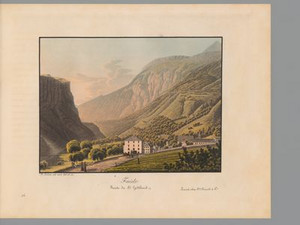
According to Lusser, "German and Italian culture" meet in Faido. The southern Alpine stone building and northern Alpine wooden construction exist side by side, while the running fountain is reminiscent of German-speaking Switzerland. However, the costume and lifestyle of the inhabitants are entirely Italian. During the Ancien Régime, Faido served as the seat of the bailiff of Uri, who ruled here with a firm hand. The 500 or so inhabitants lived from agriculture and livestock farming as well as the traffic on the Gotthard route.


Ort auf moderner Karte
GEOMETRYCOLLECTION (POINT (8.803445 46.476616), LINESTRING (8.803445 46.476616, 8.801009 46.477875))
Camera Settings (3D)
{"landscape":{"image.scale":44,"viewpoint":{"bounds":[[8.80320766472525,46.434452977171276],[8.850973995474732,46.48018574279425]],"bearing":-56.31505375473774,"pitch":85,"zoom":16.896118424190785,"center":{"lng":8.79902958869934,"lat":46.47863994744927},"cam":{"center":{"lng":8.852557475026941,"lat":46.459273441333465},"zoom":12.95702538157021,"bearing":0},"cameraToCenterDistance":1107.646491440297,"cameraPosition":{"lngLat":{"lng":8.804322747715105,"lat":46.47621036287657},"altitude":757.6404968656855},"cameraTargetElevation":715.0257812501027},"camera.fov":60},"portrait":{"camera.fov":51,"viewpoint":{"bounds":[[8.803944606282755,46.41021395590289],[8.883025767387267,46.4773425472458]],"bearing":-56.31505375473779,"pitch":85,"zoom":16.896118424190785,"center":{"lng":8.799029588711278,"lat":46.47863994744918},"cameraToCenterDistance":1340.7396316168877,"cameraPosition":{"lngLat":{"lng":8.8054366401702,"lat":46.47569906725522},"altitude":766.6083381014323},"cameraTargetElevation":715.0257812501027},"image.scale":36},"square":{"image.scale":30,"viewpoint":{"bounds":[[8.803761133484585,46.44518418518149],[8.84122710477402,46.47684883760684]],"bearing":-55.515053754149854,"pitch":85,"zoom":17.97435937200849,"center":{"lng":8.801462352257431,"lat":46.47766470368052},"cam":{"center":{"lng":8.991090989931735,"lat":46.473921462431775},"zoom":10.23012843289011,"bearing":0},"cameraToCenterDistance":1340.7396316168877,"cameraPosition":{"lngLat":{"lng":8.804468234789795,"lat":46.47624283968767},"altitude":739.4560239519302},"cameraTargetElevation":715.0257812501027}}}
Quellen

Karl Franz Lusser, accompanying text to the work Ansichten der St. Gotthards-Strasse von Flüelen bis Lugano, Zurich 1833, second part, pp. 49-53

Bilder
nb-478542
Ort
GEOMETRYCOLLECTION (POINT (8.874942 46.403155), LINESTRING (8.874942 46.403155, 8.885279 46.3902))
Titel
View from Giornico
Text

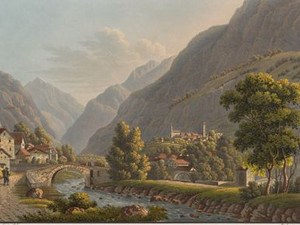
"Giornico is very lively due to the Gotthardsstrasse; you will find a good hostel and friendly service with Mr. Giudici, which is not always the case in Ticino, as in Italy. At the beginning of June there is a fair here which, next to that of Lugano, is considered the most important in the canton. Near Giornico, the valley is still narrow, the landscape rather wild, but picturesque; several streams of water gurgle down the mountains in a thousand small falls and fill the air with their sound; but just outside Giornico, the valley narrows and opens up more and more, and the road runs across fertile fields to Bodio."


Ort auf moderner Karte
GEOMETRYCOLLECTION (POINT (8.874244 46.4032), LINESTRING (8.874244 46.4032, 8.874979 46.40212))
Camera Settings (3D)
{"landscape":{"image.scale":82,"viewpoint":{"bounds":[[8.765812434543108,46.40381639546777],[8.908769287528372,46.4988917937456]],"bearing":146.2695923082092,"pitch":84.00000000000003,"zoom":17.013948815866808,"center":{"lng":8.876354992392294,"lat":46.40107017028231},"cam":{"center":{"lng":8.89022854932594,"lat":46.45542718716197},"zoom":11.901339091674673,"bearing":0},"cameraToCenterDistance":1340.7396316168877,"cameraPosition":{"lngLat":{"lng":8.872421312396256,"lat":46.40513285241525},"altitude":437.8807753015007},"cameraTargetElevation":380.7869384984343}},"portrait":{"camera.fov":51,"viewpoint":{"bounds":[[8.7658124339913,46.40381639546894],[8.908769287762624,46.4988917942712]],"bearing":146.2695923082092,"pitch":84.00000000000003,"zoom":17.013948815866808,"center":{"lng":8.876354992389679,"lat":46.40107017028333},"cameraToCenterDistance":1340.7396316168877,"cameraPosition":{"lngLat":{"lng":8.872421312393698,"lat":46.4051328524163},"altitude":437.8807753014996},"cameraTargetElevation":380.7869384984343},"image.scale":82},"square":{"image.scale":85,"viewpoint":{"bounds":[[8.76581243506405,46.40381639547155],[8.908769287346786,46.498891793303784]],"bearing":146.2695923082092,"pitch":84.00000000000003,"zoom":17.013948815866808,"center":{"lng":8.876354992384222,"lat":46.40107017028666},"cam":{"center":{"lng":9.480596696477733,"lat":46.500599063051226},"zoom":8.29820141757618,"bearing":0},"cameraToCenterDistance":1340.7396316168877,"cameraPosition":{"lngLat":{"lng":8.872421312388155,"lat":46.4051328524196},"altitude":437.88077530149616},"cameraTargetElevation":380.7869384984343}}}
Quellen

Karl Franz Lusser, accompanying text to the work Ansichten der St. Gotthards-Strasse von Flüelen bis Lugano, Zurich 1833, second part, p. 55

Bilder
nb-478543
Ort
GEOMETRYCOLLECTION (POINT (8.917481 46.376425), LINESTRING (8.917481 46.376425, 8.903904 46.382222))
Titel
View from Bodio
Text

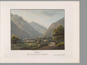
"Bodio itself lies in the middle of Unterlivinen [the lower Leventina] in a fertile plain. Here, coming from the Gotthard, you first feel like you're in Italy; fig and mulberry trees surround the place, vines climb up the trees in the Italian style or form large arbors, Panicum esculentum [a type of millet] is grown in the fields, which is not found further north."


Ort auf moderner Karte
GEOMETRYCOLLECTION (POINT (8.917288 46.376603), LINESTRING (8.917288 46.376603, 8.901844 46.382962))
Camera Settings (3D)
{"landscape":{"image.scale":72,"viewpoint":{"bounds":[[8.918822596405988,46.318546705262065],[8.990179175855985,46.37656870012563]],"bearing":-57.21507660394383,"pitch":85,"zoom":17.56071790689983,"center":{"lng":8.915359675881064,"lat":46.37767981262661},"cam":{"center":{"lng":8.986745947452192,"lat":46.35003847695745},"zoom":12.616556074391566,"bearing":0},"cameraToCenterDistance":1506.5675879442902,"cameraPosition":{"lngLat":{"lng":8.91994857285809,"lat":46.37564067822112},"altitude":356.88664613229804},"cameraTargetElevation":320.2524169922385}},"portrait":{"camera.fov":51,"viewpoint":{"bounds":[[8.918398693764601,46.33465354242301],[8.967962598925908,46.3772561226406]],"bearing":-57.215076603942975,"pitch":85,"zoom":17.569277323821726,"center":{"lng":8.91527384519577,"lat":46.377500317682745},"cameraToCenterDistance":1340.7396316168877,"cameraPosition":{"lngLat":{"lng":8.919333484921793,"lat":46.37569636338489},"altitude":353.60942081255894},"cameraTargetElevation":321.2002685546797},"image.scale":65},"square":{"image.scale":69,"camera.fov":46,"viewpoint":{"bounds":[[8.918716281265773,46.31871699853002],[8.989650761252648,46.37639577425833]],"bearing":-57.215076603942975,"pitch":85,"zoom":17.569277323821726,"center":{"lng":8.915273845198726,"lat":46.37750031768138},"cam":{"center":{"lng":9.273388681200231,"lat":46.37204090901395},"zoom":9.309222219792172,"bearing":0},"cameraToCenterDistance":1506.5675879442902,"cameraPosition":{"lngLat":{"lng":8.919835597149444,"lat":46.37547323907228},"altitude":357.6179123634111},"cameraTargetElevation":321.2002685546797}}}
Quellen

Karl Franz Lusser, accompanying text to the work Ansichten der St. Gotthards-Strasse von Flüelen bis Lugano, Zurich 1833, second part, p. 56

Bilder
nb-478544
Ort
GEOMETRYCOLLECTION (POINT (9.003055 46.283911), LINESTRING (9.003055 46.283911, 9.031448 46.24249))
Titel
View of Cresciano and Claro in the Leventina
Text

The lowest part of the Leventina, known as the Riviera, already has a very Italian climate. Accordingly, the mulberry trees thrived here, producing the finest silk in Italian-speaking Switzerland. Otherwise, the agricultural potential of the plain was apparently not fully exploited, which is probably due to the natural disasters that repeatedly hit the valley. In 1515, the area was completely destroyed by the Buzza di Biasca, a huge mudslide, and in the 18th century, landslides, debris flows and flooding of the Ticino were a recurring phenomenon.


Ort auf moderner Karte
GEOMETRYCOLLECTION (POINT (9.003356 46.283095), LINESTRING (9.003356 46.283095, 9.004176 46.281823))
Camera Settings (3D)
{"landscape":{"image.scale":19,"viewpoint":{"bounds":[[8.982400296489033,46.28317287500988],[9.0181039391733,46.30113586066972]],"bearing":156.73047215675865,"pitch":85,"zoom":17.933689019405335,"center":{"lng":9.004207849502563,"lat":46.2816250495699},"cam":{"center":{"lng":9.010224737645814,"lat":46.29292075390185},"zoom":14.309589830965868,"bearing":0},"cameraToCenterDistance":1107.646491440297,"cameraPosition":{"lngLat":{"lng":9.002983629829316,"lat":46.283592459512846},"altitude":278.6831161553492},"cameraTargetElevation":257.8484375000352}},"portrait":{"camera.fov":51,"viewpoint":{"bounds":[[8.970408908803876,46.28344588055526],[9.022803283906228,46.313140436257186]],"bearing":156.73047215675865,"pitch":85,"zoom":17.933689019405335,"center":{"lng":9.004207849501427,"lat":46.28162504957143},"cameraToCenterDistance":1340.7396316168877,"cameraPosition":{"lngLat":{"lng":9.002726005026233,"lat":46.28400647228679},"altitude":283.0675661670326},"cameraTargetElevation":257.8484375000352},"image.scale":23},"square":{"image.scale":18,"camera.fov":60,"viewpoint":{"bounds":[[8.982400296628214,46.28317287501042],[9.018103939061888,46.301135860546225]],"bearing":156.73047215675865,"pitch":85,"zoom":17.933689019405335,"center":{"lng":9.004207849502336,"lat":46.28162504957044},"cam":{"center":{"lng":9.160918508796556,"lat":46.3044889913962},"zoom":10.299638022692493,"bearing":0},"cameraToCenterDistance":1107.646491440297,"cameraPosition":{"lngLat":{"lng":9.002983629829004,"lat":46.283592459513414},"altitude":278.68311615534896},"cameraTargetElevation":257.8484375000352}}}
Quellen

Karl Franz Lusser, accompanying text to the work Ansichten der St. Gotthards-Strasse von Flüelen bis Lugano, Zurich 1833, second part, pp. 57-60; Christophe Bonnard, "Buzza di Biasca", in: Historisches Lexikon der Schweiz (HLS), version of 04.11.2004, translated from the French [23.04.2024]

Bilder
nb-478545
Ort
GEOMETRYCOLLECTION (POINT (9.019264 46.189011), LINESTRING (9.019264 46.189011, 9.053164 46.228659))
Titel
View of Bellinzona
Text

"Bellinzona is one of the three main towns of the canton of Ticino, [...] situated in a narrow passage of the Ticino valley, dominated by three old castles, surrounded by several monasteries, it has 1300 inhabitants, who live in 136 houses. This town, which was the capital of the entire canton during the mediation period, has been considerably embellished; new houses have been built in the Italian style and all the streets have been repaved."


Ort auf moderner Karte
GEOMETRYCOLLECTION (POINT (9.021077 46.18835), LINESTRING (9.021077 46.18835, 9.021921 46.18952))
Camera Settings (3D)
{"landscape":{"image.scale":36,"viewpoint":{"bounds":[[8.946916750612871,46.14583296738641],[9.027691421521013,46.18772136665973]],"bearing":28.808592203610488,"pitch":83.02959253731431,"zoom":18.548353610464904,"center":{"lng":9.02132704853966,"lat":46.18876166444218},"cam":{"center":{"lng":9.010506464147682,"lat":46.16856657793406},"zoom":13.091361608511944,"bearing":0},"cameraToCenterDistance":1311.1693066899602,"cameraPosition":{"lngLat":{"lng":9.02017677221508,"lat":46.18731366136609},"altitude":259.52280587419983},"cameraTargetElevation":237.0573852540557}},"portrait":{"camera.fov":51,"viewpoint":{"bounds":[[8.939176811422755,46.141027828946676],[9.027816155228237,46.18770289035973]],"bearing":28.808592203610488,"pitch":83.02959253731431,"zoom":18.548353610464904,"center":{"lng":9.021327048538069,"lat":46.18876166444133},"cameraToCenterDistance":1340.7396316168877,"cameraPosition":{"lngLat":{"lng":9.020150830449552,"lat":46.18728100463815},"altitude":260.029460342062},"cameraTargetElevation":237.0573852540557},"image.scale":44},"square":{"image.scale":39,"camera.fov":52,"viewpoint":{"bounds":[[8.946916750620517,46.1458329673865],[9.027691421530704,46.18772136665862]],"bearing":28.808592203610488,"pitch":83.02959253731431,"zoom":18.548353610464904,"center":{"lng":9.021327048540115,"lat":46.18876166444113},"cam":{"center":{"lng":9.350790105171399,"lat":46.19474475740742},"zoom":9.121806318388181,"bearing":0},"cameraToCenterDistance":1311.1693066899602,"cameraPosition":{"lngLat":{"lng":9.020176772215649,"lat":46.18731366136495},"altitude":259.5228058742003},"cameraTargetElevation":237.0573852540557}}}
Quellen

Karl Franz Lusser, accompanying text to the work Ansichten der St. Gotthards-Strasse von Flüelen bis Lugano, Zurich 1833, second part, p. 61

Bilder
nb-478546
Ort
GEOMETRYCOLLECTION (POINT (8.9506 46.008975), LINESTRING (8.9506 46.008975, 8.96656 45.928023))
Titel
View of Lugano with the San Salvatore
Text

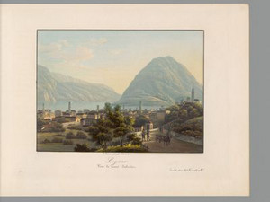
"The city of Lugano is the most substantial and richest town in the whole of Ticino, a district and county town, and one of the capitals of this canton. [...] The city contains about 390 houses, some of them very beautiful, and seven monasteries, good inns, including the "grande Auberge Suisse" of Mr. Rossi, one of the best Swiss inns. [...] Lauis [the old German name of the town] has 3600 inhabitants, many of whom are very wealthy. However, there is also a great deal of industrial activity, and the shipment of goods across the Alps to and from Lombardey, etc., enlivens the town. - Among the factories, those of silk and tobacco are the most important; several tanneries, hat factories and book printers employ many hands, as do the nearby iron, copper and brass hammers. The famous cattle market held annually in the fall, which is of great importance for the mountain cantons of Switzerland and Vorarlberg [...], is also a major source of income."


Ort auf moderner Karte
GEOMETRYCOLLECTION (POINT (8.950493 46.00899), LINESTRING (8.950493 46.00899, 8.95145 46.004832))
Camera Settings (3D)
{"landscape":{"viewpoint":{"bounds":[[8.927574662166535,45.98600926172085],[8.970978162243256,46.0099410255263]],"bearing":171.88316452382446,"pitch":82.61435817851869,"zoom":17.52333621262326,"center":{"lng":8.950850665566804,"lat":46.007486518883724},"cam":{"center":{"lng":8.960151948303633,"lat":45.99797643742886},"zoom":13.799257612726464,"bearing":0},"cameraToCenterDistance":1281,"cameraPosition":{"lngLat":{"lng":8.950181206330939,"lat":46.010746692633916},"altitude":335.2432355865179},"cameraTargetElevation":287.7761962927498}},"portrait":{"viewpoint":{"bounds":[[8.919898782406989,45.98524846155877],[8.978596736940005,46.01016898621697]],"bearing":171.88316452382927,"pitch":82.61435817851869,"zoom":17.589084907253113,"center":{"lng":8.950850665565667,"lat":46.00748651888367},"cameraToCenterDistance":1340.7396316168877,"cameraPosition":{"lngLat":{"lng":8.950181201723694,"lat":46.01074671506447},"altitude":335.24356217782724},"cameraTargetElevation":287.7761962927498}},"square":{"viewpoint":{"bounds":[[8.919898782373991,45.98524846154035],[8.97859673694333,46.01016898621819]],"bearing":171.88316452382927,"pitch":82.61435817851869,"zoom":17.589084907253113,"center":{"lng":8.950850665564758,"lat":46.00748651888486},"cam":{"center":{"lng":9.162027844972442,"lat":45.997710126789286},"zoom":9.582399055070828,"bearing":0},"cameraToCenterDistance":1340.7396316168877,"cameraPosition":{"lngLat":{"lng":8.950181201722785,"lat":46.010746715065665},"altitude":335.2435621778262},"cameraTargetElevation":287.7761962927498}}}
Quellen

Karl Franz Lusser, accompanying text to the work Ansichten der St. Gotthards-Strasse von Flüelen bis Lugano, Zurich 1833, second part, p. 68

Bilder
nb-478547
Ort
GEOMETRYCOLLECTION (POINT (8.791344 46.175343), LINESTRING (8.791344 46.175343, 8.837729 46.153188))
Titel
View of the Madonna del Sasso in Locarno
Text

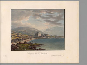
"Among the many lovely walks and viewpoints around Locarno, the Madonna del Sasso monastery in particular offers a magnificent view and no traveler should leave it unvisited in good weather."
Perhaps people have always climbed the rocky spur in the municipality of Orselina above Locarno for the beautiful view, but it was mainly pilgrims who made the pilgrimage to the shrine. In 1480, the Virgin Mary appeared to a Franciscan at this spot, whereupon a chapel was built and extended in 1616 to become the present-day church of Santa Maria Assunta. The associated monastery was closed in 1848, but resettled in 1852 under the direction of Capuchins. The church contains important works of art, including paintings by Bramantino (1456-1530) and Antonio Ciseri (1821-1891).
Locarno was an important stopover on the route to the Alpine passes due to its location on Lake Maggiore. The latest means of transportation was therefore used early on: "Since 1826, the steamboat il Verbano has made the journey from Magadino to Sesto Calende every day; departure from Magad. Morning 6 o'clock, arrival in Sesto at noon, and return to Magad. In the evening 8 o'clock; - Taxe 12 francs franc. [equivalent to about 215 Swiss francs in 2024]."


Aufnahmestandort
nb-478547
Ort auf moderner Karte
GEOMETRYCOLLECTION (POINT (8.79094 46.175656), LINESTRING (8.79094 46.175656, 8.791074 46.175627))
Camera Settings (3D)
{"landscape":{"image.scale":208,"viewpoint":{"bounds":[[8.789062864398431,45.63642878610938],[9.398963138438376,46.337980644882265]],"bearing":102.70729232387657,"pitch":74.03778829486318,"zoom":15.182111205227285,"center":{"lng":8.80306363105774,"lat":46.174035781688275},"cam":{"center":{"lng":9.384533159270148,"lat":46.01089671032969},"zoom":9.435014258947989,"bearing":0},"cameraToCenterDistance":971.6805030461402,"cameraPosition":{"lngLat":{"lng":8.785827530562642,"lat":46.1767270899544},"altitude":615.3575199780197},"cameraTargetElevation":226.21406249975033},"camera.fov":60},"portrait":{"camera.fov":51,"viewpoint":{"bounds":[[8.788375267977784,45.977652930042865],[9.044567457037147,46.22800051354531]],"bearing":102.70729232387657,"pitch":74.03778829486318,"zoom":16.011162642649875,"center":{"lng":8.797270059585571,"lat":46.17465613300584},"cameraToCenterDistance":1176.160959088466,"cameraPosition":{"lngLat":{"lng":8.785526143540466,"lat":46.176489864959336},"altitude":570.6794430544855},"cameraTargetElevation":305.5373046869994},"image.scale":138},"square":{"image.scale":169,"viewpoint":{"bounds":[[8.788375267975994,45.97765292981492],[9.044567457357033,46.22800051361543]],"bearing":102.70729232387657,"pitch":74.03778829486318,"zoom":16.011162642649875,"center":{"lng":8.797270059582843,"lat":46.17465613300649},"cam":{"center":{"lng":9.134539714342111,"lat":46.119883805273446},"zoom":9.848872121583081,"bearing":0},"cameraToCenterDistance":1176.160959088466,"cameraPosition":{"lngLat":{"lng":8.785526143537908,"lat":46.17648986495999},"altitude":570.6794430544824},"cameraTargetElevation":305.5373046869994}}}
Quellen

Karl Franz Lusser, accompanying text to the work Ansichten der St. Gotthards-Strasse von Flüelen bis Lugano, Zurich 1833, second part, p. 72; Daniela Pauli Falconi, "Madonna del Sasso", in: Historisches Lexikon der Schweiz (HLS), version of 28.08.2008, translated from Italian [29.04.2024]

Bitte berühren!