Chur likes to call itself "the oldest town in Switzerland". As early as 13,000 years ago, hunters and gatherers left their marks on the place of the later settlement. However, Chur only gained greater importance as a bishop's seat from around 400 AD. The cathedral with the surrounding buildings, the so-called "Hof", was under the control of the bishops and only became part of the municipality of Chur in 1852. The most important branch of industry has always been transit traffic: Chur was located on an important trade route from southern Germany to northern Italy, which led over the Bernardin and Splügen passes, among others. We will follow these routes below.
https://www.chur.ch/geschichte [08.07.2024]; Jürg Simonett; Jürg Rageth; Anne Hochuli-Gysel; Linus Bühler; Martin Bundi; Max Hilfiker: "Chur (municipality)", in: Historisches Lexikon der Schweiz (HLS), version of 03.08.2021 [08.07.2024]
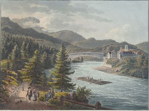
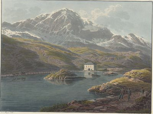
The Vorderrhein and Hinterrhein rivers flow together at the Reichenau bridge. The castle next to it was built in the 17th century and housed a school from 1793-98. One of its teachers was a certain Monsieur Chabos, whose real name was Louis Philippe d'Orléans and who was to become King of France in 1830. The château was renovated in 1820, when it came into the possession of the von Planta family, and in this state it is depicted here.
Linus Bühler, "Reichenau (GR)", in: Historical Dictionary of Switzerland (HLS), version of 23.08.2010 [11.07.2024]
The southern road from the Splügen and San Bernardino Pass, on which we are standing here, meets the road coming from the Oberalp Pass in Reichenau. This road leads past the foot of the church hill of Tamins in the background of the picture.
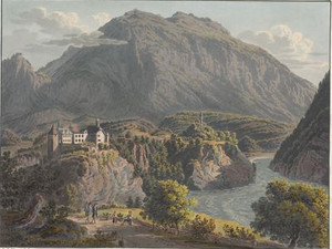
Rhäzüns Castle towers high above the Hinterrhein, first mentioned in 1288, when it was owned by the eponymous Lords of Rhäzüns. Since then, it has been repeatedly extended and expanded. Inside are valuable wall paintings from the 14th century depicting the legend of Tristan and Isolde. However, the castle cannot be visited as it is privately owned.
Erwin Poeschel, Die Kunstdenkmäler des Kantons Graubünden, Band 3, Räzünser Boden, Domleschg, Heinzenberg, Oberhalbstein und Unterengadin, Basel 1940, pp. 72-78; https://www.burgenwelt.org/schweiz/rhaezuens/object.php [11.07.2024]
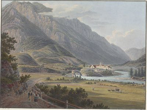
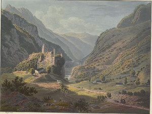
The Ortenstein Castle was the center of the manor of the same name and was built in the 13th century. The castle and manor changed hands several times. Today, the manor essentially corresponds to the municipality of Domleschg, the castle is privately owned and is still inhabited.
Jürg Simonett, "Ortenstein", in: Historical Dictionary of Switzerland (HLS), version of 05.12.2016 [11.07.2024]
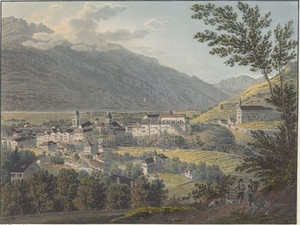
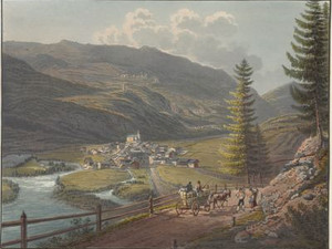
"The focal point of the drawing on this panel is at the end of the village of Käzis [Cazis], which, although it was terribly devastated by a stream bursting its banks in 1819, offers a picturesque view, as it is shaded on all sides by beautiful fruit trees."
J.J. Meyer; J. G. Ebel, Voyage pittoresque dans le Canton des Grisons en Suisse: vers le lac Majeur et le lac de Come: sur les grandes routes novellement construites à travers les Cols de Splugen et de Bernhardin en 32 planches, Zürich 1827, p. 85
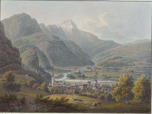
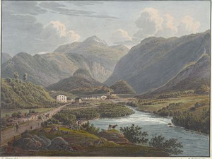
"The drawing shows the entire remarkable location of Thusis. In front you can see Sils and opposite Thusis, the old and the new Nolla bridge, the old paths to Rongella and Viamala and the new road leading to the Verlorene Loch [lost hole]. The whole is dominated by the mountains of Joms [Schams] and the mighty Piz Beverin [...]."
J.J. Meyer; J. G. Ebel, Voyage pittoresque dans le Canton des Grisons en Suisse: vers le lac Majeur et le lac de Come: sur les grandes routes novellement construites à travers les Cols de Splugen et de Bernhardin en 32 planches, Zurich 1827, pp. 93-94
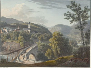
This view from the south shows the more recent bridge over the Nolla, which was built in 1818-1823 and was part of the extension of the art road over the Graubünden passes. It is still preserved today and is used by local traffic. Of course, it has been gently adapted to the requirements of automobile traffic.
Inventory of historic transport routes in Switzerland, GR 15.10.1 (PDF) [12.07.2024]
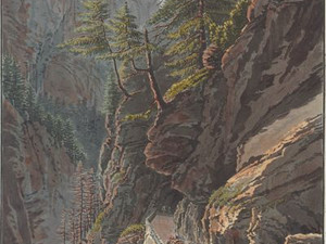
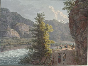
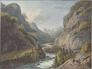
Between Domleschg and Schamsertal, the new highway - just like the Hinterrhein - squeezes through a narrow gorge. This is called the Viamala because it has always been a major obstacle to traffic. Johann Gottfried Ebel recalls in the accompanying text of this view: "The author of this book, who made a short trip to Thusis in the fall of 1819, dared to take his steps in this gorge over a kind of bridge made of tree trunks supported by high posts, which ran along the jagged sides of the rocks. From this fragile and dangerous bridge, he contemplated the horrors of the gorge. And although he was accustomed to the terrible scenes which often take place in the high Alps, he was not relieved of the terror which this awful precipice inspired in him until he could return to the valley. Any description of this wild nature would be incomplete and would fall short of reality."
J.J. Meyer; J. G. Ebel, Voyage pittoresque dans le Canton des Grisons en Suisse: vers le lac Majeur et le lac de Come: sur les grandes routes novellement construites à travers les Cols de Splugen et de Bernhardin en 32 planches, Zurich 1827, p. 111
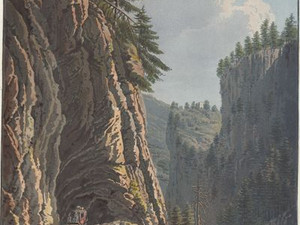
By 1821, however, the road through the gorge was completed. An important section was the so-called Lost Hole, where the road had to pass through a tunnel. According to Ebel, this tunnel was around 65 meters long and around four meters high and wide. The gorge was still around 80-90 meters deep at this point up to the road.
J.J. Meyer; J. G. Ebel, Voyage pittoresque dans le Canton des Grisons en Suisse: vers le lac Majeur et le lac de Come: sur les grandes routes novellement construites à travers les Cols de Splugen et de Bernhardin en 32 planches, Zürich 1827, pp. 111-112
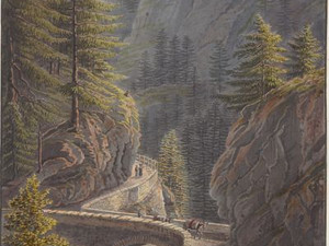
The road crosses the wild Viamala basin twice. Both bridges were built in 1738/39 and later only slightly adapted for the road. They are also known as the "Wildener bridges" after their builder. Only the southern abutment of this northern Wildener Bridge remains today.
Inventory of historic transport routes in Switzerland, GR 15.1.3 (PDF) [15.07.2024]
The southern Wildener Bridge is still preserved today. It is 13.5 meters long, with an arch radius of seven meters. The roadway is three meters wide and was only provided with additional arches at the two slip roads when the line was extended in 1821 to allow stagecoaches to turn.
Inventory of historic transport routes in Switzerland, GR 15.1.3 (PDF) [15.07.2024]
At the upper exit of the Viamala, the road crossed the Hinterrhein again at Punt da Tgiern. This bridge was built in 1473 and continued to be used by the road from 1818/23. In 1834, it fell victim to a 'flood of the century', which destroyed almost all the bridges in the canton of Graubünden. As a result, the bridge was moved around one kilometer further downstream near the hamlet of Rania.
Inventory of historic transport routes in Switzerland, GR 15.10.1 (PDF) [15.07.2024]
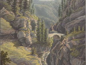
"As soon as the traveler has left the third bridge of the Viamala behind him, he finds himself at the entrance to the Schamstal, which seems all the more cheerful because it suddenly erases the gruelling impression that the gloomy passage he had to cover for over an hour must naturally have produced. [...] However exaggerated the expression may seem, we have no hesitation in saying that the new road runs through the bowels of the mountains and is in every way one of the most remarkable sights in Switzerland. Such gigantic scenes in such wild nature are not to be seen anywhere else in the Alpine chain."
J.J. Meyer; J. G. Ebel, Voyage pittoresque dans le Canton des Grisons en Suisse: vers le lac Majeur et le lac de Come: sur les grandes routes novellement construites à travers les Cols de Splugen et de Bernhardin en 32 planches, Zurich 1827, p. 116
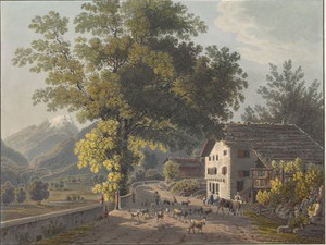
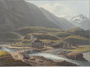
Andeer was a village with around 500 inhabitants around 1820, which benefited from traffic over the Alpine passes. In addition, iron ore was mined and a spa was operated from 1829. In the course of the 19th century, Andeer replaced Zillis as the main town in Schams.
Jürg Simonett, "Andeer", in: Historisches Lexikon der Schweiz (HLS), version of 02.12.2016 [15.07.2024]
"It is worth lingering here for a moment to contemplate the sublime scene of the Aversbach stream emerging from a dark, rocky gorge and plunging with a loud roar into the majestic waters of the Rhine, which have just emerged from the Roffla gorge on the other side. To enjoy this view to the full, you have to descend to the small headland that juts out into the bed of the Rhine at lunchtime. The view from there is terrifying yet magnificent, especially when illuminated by the sun."
J.J. Meyer; J. G. Ebel, Voyage pittoresque dans le Canton des Grisons en Suisse: vers le lac Majeur et le lac de Come: sur les grandes routes novellement construites à travers les Cols de Splugen et de Bernhardin en 32 planches, Zurich 1827, p. 133
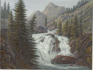
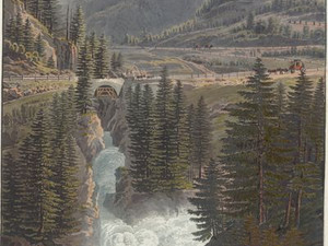
The Rofla is the second gorge passage along the road from Chur to Splügen. It is less spectacular than the Viamala, but Johann Jakob Meyer still found a beautiful waterfall of the Rhine here, which could be described as the 'upper Rhine Falls'. "Half a mile from Andeer and not far from the confluence of the Aversbach and the Hinterrhein, you come to this gorge, which is half a mile long. Less terrifying than the Viamala, it offers alternating wild and sublime scenery along the terribly torn gneiss and porphyry cliffs and several falls of the Rhine, presented in an extremely picturesque way by groups of magnificent pines and larches."
J.J. Meyer; J. G. Ebel, Voyage pittoresque dans le Canton des Grisons en Suisse: vers le lac Majeur et le lac de Come: sur les grandes routes novellement construites à travers les Cols de Splugen et de Bernhardin en 32 planches, Zurich 1827, pp. 137-138
Shortly before the village of Sufers with its 200 inhabitants, the path leads through another wild rocky passage. However, the view as shown in this picture no longer exists today: the Rhine was dammed in 1959-62 and the 19th century road sank under water. In the past, the road did not even lead into the village of Sufers, but ran along the Hinterrhein on the opposite side of the valley.
Kurt Wanner, "Sufers", in: Historisches Lexikon der Schweiz (HLS), version of 20.07.2012 [15.07.2024]; Inventar historischer Verkehrswege der Schweiz, GR 15.10 (PDF) [15.07.2024]
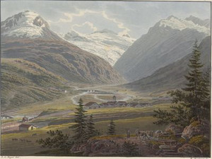
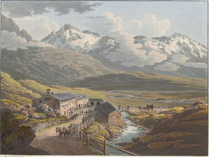
Johann Gottfried Ebel wrote about the Rheinwald valley, whose main town is Splügen: "Enormous glaciers weigh down on these mountains. The valley is exposed to terrible floods. The winter lasts nine months; the grass shoots at the end of June, and all the hay must be collected by the end of August."
Of course, Splügen, laying on the foot of an alpine pass, took an active part in the goods traffic over the pass of the same name: "It is estimated that between 20,000 and 25,000 pack animals transport bundles of goods between Germany, Switzerland and Italy at this transshipment point every year. The forwarding merchants to whom these goods are entrusted are equally well-known for their zeal and commitment to the travellers."
Johann Gottfried Ebel, Anleitung, auf die nützlichste und genussvollste Art die Schweitz bereisen, vol. 4, Zurich 1810, p. 106; J.J. Meyer; J. G. Ebel, Voyage pittoresque dans le Canton des Grisons en Suisse: vers le lac Majeur et le lac de Come: sur les grandes routes novellement construites à travers les Cols de Splugen et de Bernhardin en 32 planches, Zurich 1827, p. 142
Hinterrhein is the northern valley town of the Berhardin Pass. However, the nearby headwaters of the Hinterrhein were also of great interest to tourists in the 18th and 19th centuries. This could be reached on foot in three hours. While Ebel still describes the large and magnificent ice vault from which the Hinterrhein emerges, there is not much to be seen of glaciers today.
Johann Gottfried Ebel, Anleitung, auf die nützlichste und genussvollste Art die Schweitz zu bereisen, vol. 4, Zurich 1810, p. 108
The people of Graubünden spared no effort to keep the pass roads open all year round:
"Between the village of Hinterrhein and the village of St. Bernardin, over a length of three lieues [approx. 12 km], eight men are busy ploughing the road all day long. If the weather is constantly clear, there are only two, but sometimes 30 or 40 men and two oxen. The most arduous work, the so-called scooping, which determines whether the traveler can move on, takes place in spring. If one wanted to wait until the snow had melted away, it could happen that neither wagons nor sledges could travel over the Bernardin Pass for three, four or even five weeks between spring and summer. [...] In 1824, there were still 30 feet [10 m] of snow on the Bernardin road at the beginning of June. From May 26 to June 15, the postal administration had about 1 million cubic feet [approx. 28,000 m³] of snow removed, so that after the work was completed at the end of June, the wagons could still pass places where the snow walls were 8 to 10 feet [approx. 3 m] high. In the spring of 1825, the scooping work was already completed by the end of April. [...] All those engaged in clearing snow in winter and spring are under the supervision of an inspector and are paid by the cantonal government. These costs amount to the sum of 4300 guilders. Neither the travelers nor the carters pay anything for this, apart from the usual road toll. The posts are provided with the men they need free of charge. Those traveling with hired coachmen pay for the services rendered to them."
J.J. Meyer; J. G. Ebel, Voyage pittoresque dans le Canton des Grisons en Suisse: vers le lac Majeur et le lac de Come: sur les grandes routes novellement construites à travers les Cols de Splugen et de Bernhardin en 32 planches, Zurich 1827, pp. 175-176
The village of San Bernardino was not only known for its location on the pass road. With the opening of the new road, a spa was also to be established: "The most remarkable thing it has to offer is the mineral water spring that rises here. It has a temperature of 7 1/2°, contains a lot of carbonic acid, sulphuric lime, carbonate of lime, calcareous earth and iron oxide and supplies 2 1/4 pots of 48 ounces [approx. 3 l] every minute. A new inn was built here in 1822, intended for water drinkers and where baths were to be set up. In 1826 there were already two inns with 50 or 60 Italians and a few people from Graubünden drinking the mineral water, which the locals call Aqua forte and which is extremely pleasant to drink. This spring and these baths, which are certainly excellent, are probably the highest in the Alpine chain."
J.J. Meyer; J. G. Ebel, Voyage pittoresque dans le Canton des Grisons en Suisse: vers le lac Majeur et le lac de Come: sur les grandes routes novellement construites à travers les Cols de Splugen et de Bernhardin en 32 planches, Zurich 1827, pp. 181-182
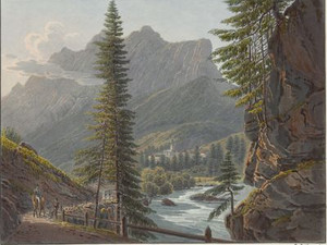
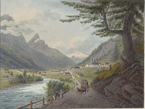
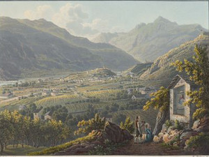
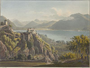
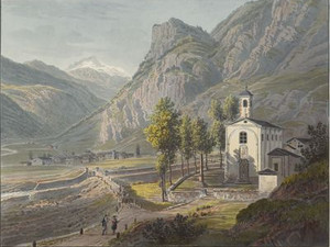
South of the Bernardin Pass, we enter the Misox/Mesocco, which is Italian-speaking but still belongs to the canton of Graubünden. Once you have crossed the village of Crimei, you soon have a magnificent view: "This part of the trail offers the greatest variety of picturesque images when the rays of light and shade are favorable. Half a mile below Crimei, the hill with the imposing ruins of Misox Castle (Castello or Castellatsch di Misocco) rises in the middle of the valley. What lover of beautiful nature and history could resist climbing this hill and taking a closer look at the ruins? The place where this scene of past greatness is located is very romantic. On the right, in a hollow, you can see the perched village of Soazza with its picturesque church [...]."
J.J. Meyer; J. G. Ebel, Voyage pittoresque dans le Canton des Grisons en Suisse: vers le lac Majeur et le lac de Come: sur les grandes routes novellement construites à travers les Cols de Splugen et de Bernhardin en 32 planches, Zurich 1827, pp. 189-190
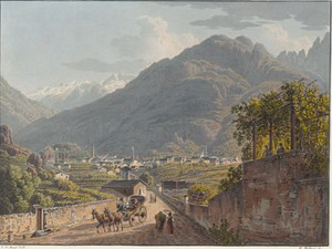
"Bellinzona, one of the five towns in the canton of Ticino, is the southern key to Switzerland. Its three castles [...] defend this important passage, and a long, crenellated wall [...] closes the valley, which narrows at this point. This place defends the entrance to the Misox, Blegno and Leventina valleys as well as the access to the Bernardin, Lukmanier and St. Gotthard passes, all 11 to 12 lieues away, and the Lufenen [Nufenen] pass, 17 lieues away, which leads from Upper Leventina to the canton of Valais. [...] Bellinzona has always benefited greatly from the transit of all goods going to Italy or coming over the passes [...]. Before the roads were built, 20,000 packhorses passed through the town every year. A considerable trade is conducted at the large cattle market, which is held for two weeks in the plain near Bellinzona [...], where 10,000 cows, oxen and horses from German-speaking Switzerland were often sold to Italians from Lombardy [...]."
J.J. Meyer; J. G. Ebel, Voyage pittoresque dans le Canton des Grisons en Suisse: vers le lac Majeur et le lac de Come: sur les grandes routes novellement construites à travers les Cols de Splugen et de Bernhardin en 32 planches, Zurich 1827, pp. 201-202, 220
"Indescribably beautiful views at the Madonna del Sasso monastery" - Perhaps people have always climbed the rocky spur in the municipality of Orselina above Locarno for the beautiful view, but it was mainly pilgrims who made the pilgrimage to the shrine. In 1480, the Virgin Mary appeared to a Franciscan at this spot, whereupon a chapel was built and extended in 1616 to become the present-day church of Santa Maria Assunta. The associated monastery was closed in 1848, but resettled in 1852 under the direction of Capuchins. There are important works of art in the church, including paintings by Bramantino (1456-1530) and Antonio Ciseri (1821-1891).
Johann Gottfried Ebel, Anleitung, auf die nützlichste und genussvollste Art die Schweitz zu bereisen, vol. 3, Zurich 1810, p. 353; Daniela Pauli Falconi, "Madonna del Sasso", in: Historisches Lexikon der Schweiz (HLS), version of 28.08.2008, translated from Italian [29.04.2024]
The Splügen Pass road from 1818-1822 was financed entirely by the Lombardo-Venetian Kingdom, as it provided a direct link to German-speaking Switzerland and southern Germany, bypassing Ticino. "The advantages for trade resulting from the construction of this road are obvious. In the past, goods sent from Chur to Chiavenna took six or seven days. Now they only take two or three days, and the traveler who takes the mail can get from Chur to Chiavenna in ten or 12 hours. Goods sent from Milan regularly arrive in Zurich in eight days. For some months now, express wagons have been set up between Genoa and Frankfurt am Main, transporting bales of goods from one city to another in 14 days, whereas before the new roads were built in Graubünden, goods took 30 to 50 days to travel."
J.J. Meyer; J. G. Ebel, Voyage pittoresque dans le Canton des Grisons en Suisse: vers le lac Majeur et le lac de Come: sur les grandes routes novellement construites à travers les Cols de Splugen et de Bernhardin en 32 planches, Zurich 1827, pp. 256-257; Inventar historischer Verkehrswege der Schweiz, GR 17 (PDF) [22.07.2024]
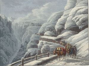
The Cardinello Gorge takes its name from the neighboring Monte Cardine. It means the pivotal point of the valley. The rocky chasms were probably first breached in 1643, but it was not until after 1709 that the path was finally widened and fitted with new retaining walls, ledges and galleries. The Cardinello Gorge was always regarded as the most dangerous section of the entire Splügen route and once cost the lives of many a muleteer, mercenary or pilgrim.
The crossing of the French Armée des Grisons under the leadership of Marshal McDonald in December 1800 therefore caused all the more of a stir. Despite raging winter storms, around 15,000 men set off from Splügen. In the Cardinello Gorge, avalanches swept hundreds of soldiers into the depths.
"The two shelters and the three galleries that had to be built show that the road in this direction offers no more safety from falling avalanches than the old route through the Cardinello Gorge. The experience gained in recent years proves that these measures are not yet sufficient to protect the road. An extension of the third gallery is currently being built (in the summer and fall of 1826). It seems that it is believed that even this will not be enough, for it is said that a company of shareholders in Milan is seriously considering a plan to drive a tunnel through the entire Splügen mountain from Isola to the village of Splügen; the cost of this is estimated at 5 million. This huge tunnel was to be lit by hydrogen gas."
This ambitious plan was never realized. The tunnel would have been at least 12 kilometers long, the first crest tunnel ever and almost 60 years before the Gotthard railroad tunnel!
J.J. Meyer; J. G. Ebel, Voyage pittoresque dans le Canton des Grisons en Suisse: vers le lac Majeur et le lac de Come: sur les grandes routes novellement construites à travers les Cols de Splugen et de Bernhardin en 32 planches, Zurich 1827, pp. 281-282
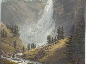
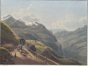
Shortly after Pianazzo, the carriage road leads past the 180-metre-high waterfall formed by the Scalcoggia stream. In 1834, the section of road between Isola and Campodolcino had to be rebuilt following storm damage. From then on, the road no longer led through the gorge, but above the edge of the terrain through the village of Pianazzo.
J.J. Meyer; J. G. Ebel, Voyage pittoresque dans le Canton des Grisons en Suisse: vers le lac Majeur et le lac de Come: sur les grandes routes novellement construites à travers les Cols de Splugen et de Bernhardin en 32 planches, Zürich 1827, p. 289; https://www.in-lombardia.it/it/cascata-di-pianazzo [22.07.2024]; Jürg Simonett, "Splügenpass", in: Historical Dictionary of Switzerland (HLS), version of 10.01.2013 [22.07.2024]
Click on "Open image details" for more information.
"The people, the language, the soil, the landscapes that nature offers announce a different country to those coming from the north, and everything proves to them that they are in Italy. You walk through fig, mulberry and almond trees, cypresses and laurel trees; the gardens are adorned with pomegranate and orange trees; chestnut forests cover the lower mountain slopes; excellent wine grows everywhere, and a flora with the most beautiful plants [...] delights the eye." Chiavenna is the center of Valchiavenna, which belonged to Graubünden as a subject territory from 1512 to 1797. From 1815, the area was then part of the Lombardo-Venetian Kingdom. The importance of the town - similar to Bellinzona - comes from its location at the junction of various mountain passes, in this case the Splügen, Septimer, Maloja and Julier passes.
J.J. Meyer; J. G. Ebel, Voyage pittoresque dans le Canton des Grisons en Suisse: vers le lac Majeur et le lac de Come: sur les grandes routes novellement construites à travers les Cols de Splugen et de Bernhardin en 32 planches, Zurich 1827, pp. 295-296; Guido Scaramellini, "Chiavenna", in: Historisches Lexikon der Schweiz (HLS), version of 07.05.2015, translated from Italian [22.07.2024]
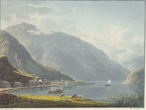
"Riva on Lago di Chiavenna is the staging point for all goods coming from or going to Italy via Lake Como. This place has only a few houses and the traveler can hardly find adequate accommodation there, but he can get wagons and horses there to get to Chiavenna."
Lago di Chiavenna no longer exists today. Due to the lowering of the lake level, it was divided into the Pozzo di Riva and Lago di Mezzola during the 19th century. As early as 1826, it was only connected to Lake Como by a navigable canal. The distance by boat to Como was 14-15 hours.
J.J. Meyer; J. G. Ebel, Voyage pittoresque dans le Canton des Grisons en Suisse: vers le lac Majeur et le lac de Come: sur les grandes routes novellement construites à travers les Cols de Splugen et de Bernhardin en 32 planches, Zurich 1827, pp. 314-315
Voyage pittoresque dans le Canton des Grisons en Suisse : vers le lac Majeur et le lac de Come: sur les grandes routes novellement construites à travers les Cols de Splugen et de Bernhardin en 32 planches / par J. J. Meyer ; accompagné d'une introduction et explication de Mr. le Docteur J.G. Ebel ; Avec une carte routière de H. Keller, Zurich: chez J. J. Meyer, peintre, 1827