EN Voyage pittoresque aux Lacs Majeur et de Lugano, 1823

On the shores of Lake Maggiore and Lake Lugano
Bilder
nb-481658
Titel
View of Locarno
Text

Back in the 19th century, Locarno was a very popular place because of its microclimate. Until 1815, however, the city was difficult to access by land because the Torretta bridge between Bellinzona and Carasso had been destroyed in 1515.

"The public buildings that the city of Locarno currently contains are not very numerous and only a few are characterized by a beautiful style. The cathedral, an old building of shabby appearance, is situated in Muralto, a small fishing village belonging to the town, but the town contains an Ursuline convent and two Franciscan convents; the convent of the latter order, which occupies the end of the town opposite the Maggia, is a beautiful and spacious building. The climate in Locarno is very mild and the town is in a charming position; protected to the north by Monte Gridone, it is very well exposed to the south-west. The view shown here was drawn on the other side of the Maggia river, where it flows into the lake. The building that can be seen on the hill to the right is the Madonna del Sasso monastery; its position on a vertical rock face is very remarkable and the view that can be enjoyed there is full of beauty."


Aufnahmestandort
nb-481658
Ort auf moderner Karte
GEOMETRYCOLLECTION (POINT (8.805276 46.171285), LINESTRING (8.805276 46.171285, 8.804829 46.17125))
Camera Settings (3D)
{"landscape":{"image.scale":51,"viewpoint":{"bounds":[[8.806988090084019,46.15539640848942],[8.824032711255512,46.18022473736667]],"bearing":-87.30339428085533,"pitch":85,"zoom":18.04856418149546,"center":{"lng":8.804520070552826,"lat":46.171294265127614},"cam":{"center":{"lng":8.824480854909865,"lat":46.16850224444357},"zoom":14.462381341177316,"bearing":0},"cameraToCenterDistance":1107.646491440297,"cameraPosition":{"lngLat":{"lng":8.807378566417356,"lat":46.17120103069993},"altitude":215.00531030662685},"cameraTargetElevation":195.72656250000094},"camera.fov":60},"portrait":{"image.scale":33,"viewpoint":{"bounds":[[8.806988090082939,46.155396408367636],[8.82403271138557,46.180224737436646]],"bearing":-87.30339428085533,"pitch":85,"zoom":18.04856418149546,"center":{"lng":8.804520070551689,"lat":46.17129426512767},"cameraToCenterDistance":1107.646491440297,"cameraPosition":{"lngLat":{"lng":8.80737856641619,"lat":46.17120103069996},"altitude":215.00531030662682},"cameraTargetElevation":195.72656250000094}},"square":{"image.scale":33,"viewpoint":{"bounds":[[8.806988090085923,46.15539640848124],[8.82403271126978,46.180224737375624]],"bearing":-87.30339428085533,"pitch":85,"zoom":18.04856418149546,"center":{"lng":8.804520070554645,"lat":46.1712942651275},"cam":{"center":{"lng":8.892211196005178,"lat":46.17371377089259},"zoom":11.366392750120307,"bearing":0},"cameraToCenterDistance":1107.646491440297,"cameraPosition":{"lngLat":{"lng":8.807378566419231,"lat":46.17120103069976},"altitude":215.00531030662688},"cameraTargetElevation":195.72656250000094}}}
Quellen

Voyage pittoresque aux Lacs Majeur et de Lugano, Zurich 1828, pp. 13-14; Rosanna Janke; Rodolfo Huber, "Locarno (municipality)", in: Historical Dictionary of Switzerland (HLS), version of 20.12.2022, translated from the Italian [28.05.2023]


Bilder
nb-481659
Titel
View of Luino
Text

Luino is a small town on the eastern shore of Lake Maggiore and is already located in Italy. Nevertheless, it once belonged to the Confederation of 13 cantons as a subject territory before it was exchanged for Mendrisio. From the second half of the 19th century, Luino was able to do a lot of trade with Switzerland thanks to the development of the railroads and the industrialization of the town.


Aufnahmestandort
nb-481659
Ort auf moderner Karte
GEOMETRYCOLLECTION (POINT (8.748776 46.006523), LINESTRING (8.748776 46.006523, 8.740203 46.001926))
Camera Settings (3D)
{"landscape":{"image.scale":44,"viewpoint":{"bounds":[[8.724078164909542,45.99258455576131],[8.750439268865222,46.007925657057854]],"bearing":-139.50639012849444,"pitch":80,"zoom":18.416485415474646,"center":{"lng":8.748778402807147,"lat":46.00655409612628},"cam":{"center":{"lng":8.742358094789694,"lat":46.00025563811016},"zoom":14.965297119613926,"bearing":0},"cameraToCenterDistance":1282.6385684316433,"cameraPosition":{"lngLat":{"lng":8.750426798483772,"lat":46.00789493072398},"altitude":288.12792948345566},"cameraTargetElevation":253.55804443359378}},"portrait":{"viewpoint":{"bounds":[[8.724078164917927,45.99258455577032],[8.750439268864568,46.00792565705797]],"bearing":-139.50639012849444,"pitch":80,"zoom":18.416485415474646,"center":{"lng":8.748778402806465,"lat":46.00655409612628},"cameraToCenterDistance":1282.6385684316433,"cameraPosition":{"lngLat":{"lng":8.750426798483005,"lat":46.00789493072398},"altitude":288.12792948345566},"cameraTargetElevation":253.55804443359378}},"square":{"viewpoint":{"bounds":[[8.724078164920343,45.99258455576441],[8.750439268863403,46.00792565705885]],"bearing":-139.50639012849444,"pitch":80,"zoom":18.416485415474646,"center":{"lng":8.748778402805328,"lat":46.006554096127445},"cam":{"center":{"lng":8.832817718685504,"lat":46.00025563811221},"zoom":10.73729849770646,"bearing":0},"cameraToCenterDistance":1282.6385684316433,"cameraPosition":{"lngLat":{"lng":8.750426798481925,"lat":46.00789493072514},"altitude":288.1279294834549},"cameraTargetElevation":253.55804443359378},"image.scale":49}}
Quellen

Voyage pittoresque aux Lacs Majeur et de Lugano, Zurich 1828, pp. 15-16; https://www.lelacmajeur.com/fr_FR/home/destinations/varese-et-rive-est/luino [28.05.2023]

Bilder
nb-481660
Titel
View from Laveno
Text

Laveno is a "small, fairly regularly built" town, writes the accompanying text. At the bay of Laveno, Lake Maggiore reaches its greatest width between Baveno and Laveno. The Boesio flows into Lake Maggiore from the right here, but is concealed by a hill.


Aufnahmestandort
nb-481660
Ort auf moderner Karte
GEOMETRYCOLLECTION (POINT (8.611184 45.906729), LINESTRING (8.611184 45.906729, 8.614038 45.907494))
Camera Settings (3D)
{"landscape":{"camera.fov":60,"image.scale":46,"viewpoint":{"bounds":[[8.530941035759952,45.86279429350611],[8.611111043847387,45.927635627209526]],"bearing":57.17738781059563,"pitch":84,"zoom":16.950702831925142,"center":{"lng":8.614728120007726,"lat":45.908744531246384},"cam":{"center":{"lng":8.594337899936932,"lat":45.89702710788845},"zoom":13.084570160902324,"bearing":0},"cameraToCenterDistance":1107.646491440297,"cameraPosition":{"lngLat":{"lng":8.609589580617182,"lat":45.90643828986617},"altitude":242.7244820507001},"cameraTargetElevation":193.00000000000182}},"portrait":{"image.scale":56,"viewpoint":{"bounds":[[8.609657562174448,45.83679153557907],[8.82664209103308,46.02691562612762]],"bearing":61.17738781059597,"pitch":75.99999999999999,"zoom":17.32932019754877,"center":{"lng":8.613210124814714,"lat":45.907632551903845},"cameraToCenterDistance":1107.646491440297,"cameraPosition":{"lngLat":{"lng":8.60918986146919,"lat":45.90609322646398},"altitude":281.5206094781389},"cameraTargetElevation":193.00000000000182}},"square":{"image.scale":51,"viewpoint":{"bounds":[[8.557673302538376,45.877633933990666],[8.61027123128224,45.92583444405173]],"bearing":64.37738781008181,"pitch":85,"zoom":16.950706028451716,"center":{"lng":8.614563706218405,"lat":45.908336429308946},"cam":{"center":{"lng":8.82066294625767,"lat":45.92003761592889},"zoom":9.740703297419461,"bearing":0},"cameraToCenterDistance":1107.646491440297,"cameraPosition":{"lngLat":{"lng":8.609041015618743,"lat":45.90649340403024},"altitude":234.46044332186813},"cameraTargetElevation":193.00000000000182}}}
Quellen

Voyage pittoresque aux Lacs Majeur et de Lugano, Zurich 1828, no p.

Bilder
nb-481661
Titel
View from Intra
Text

The inhabitants of Intra practiced various trades: They dyed and washed textiles and processed copper and iron, which they obtained in large quantities from abroad. However, the transportation of goods across the Alps was of the greatest importance, as goods were reloaded here to be transported from the Mediterranean ports across the Gotthard to Switzerland and Germany.


Aufnahmestandort
nb-481661
Ort auf moderner Karte
GEOMETRYCOLLECTION (POINT (8.562348 45.922831), LINESTRING (8.562348 45.922831, 8.573542 45.930917))
Camera Settings (3D)
{"landscape":{"image.scale":36,"viewpoint":{"bounds":[[8.528410550320928,45.92188884035451],[8.788464893888573,46.04319173493084]],"bearing":29.514115017293307,"pitch":78.02748370716857,"zoom":18.70190488202765,"center":{"lng":8.562490940093994,"lat":45.9229457812761},"cam":{"center":{"lng":8.725404628309462,"lat":45.98774368741141},"zoom":11.562185968835404,"bearing":0},"cameraToCenterDistance":1107.646491440297,"cameraPosition":{"lngLat":{"lng":8.561610751237225,"lat":45.921864188631446},"altitude":311.1123404938515},"cameraTargetElevation":281.80624999978187},"camera.fov":60},"portrait":{"image.scale":36,"viewpoint":{"bounds":[[8.528410550318284,45.92188884035511],[8.788464892669424,46.04319173439595]],"bearing":29.514115017293307,"pitch":78.02748370716857,"zoom":18.70190488202765,"center":{"lng":8.562490940093994,"lat":45.92294578127664},"cameraToCenterDistance":1107.646491440297,"cameraPosition":{"lngLat":{"lng":8.561610751237112,"lat":45.92186418863204},"altitude":311.1123404938512},"cameraTargetElevation":281.80624999978187}},"square":{"image.scale":39,"viewpoint":{"bounds":[[8.52841055055606,45.92188884035593],[8.788464891699391,46.04319173381174]],"bearing":29.514115017293307,"pitch":78.02748370716857,"zoom":18.70190488202765,"center":{"lng":8.562490940091834,"lat":45.92294578127752},"cam":{"center":{"lng":9.8286822562726,"lat":46.072852690866284},"zoom":7.434968069861838,"bearing":0},"cameraToCenterDistance":1107.646491440297,"cameraPosition":{"lngLat":{"lng":8.561610751234952,"lat":45.921864188632895},"altitude":311.11234049385075},"cameraTargetElevation":281.80624999978187}}}
Quellen

Voyage pittoresque aux Lacs Majeur et de Lugano, Zurich 1828, no p.

Bilder
nb-481662
Titel
View of the Isola San Giovanni, called Isolino
Text

After the small island of Brissago, Isola San Giovanni is the second smallest island in Lake Maggiore. It has a pretty manor house and some gardens. Part of the town of Pallanza can be seen in the background.


Aufnahmestandort
nb-481662
Ort auf moderner Karte
GEOMETRYCOLLECTION (POINT (8.559945 45.915619), LINESTRING (8.55799 45.916385, 8.559945 45.915619))
Camera Settings (3D)
{"landscape":{"image.scale":36,"viewpoint":{"bounds":[[8.560169981831706,45.87985107465906],[8.599687144113716,45.92301862941139]],"bearing":-65.42878621028882,"pitch":85,"zoom":17.122214882099627,"center":{"lng":8.556142151365407,"lat":45.916806920065994},"cam":{"center":{"lng":8.603724947270734,"lat":45.90327899237437},"zoom":13.054891905254049,"bearing":0},"cameraToCenterDistance":1107.646491440297,"cameraPosition":{"lngLat":{"lng":8.561088152100353,"lat":45.915233601653455},"altitude":229.98223236780828},"cameraTargetElevation":193.1745605250462}},"portrait":{"image.scale":36,"viewpoint":{"bounds":[[8.560169981834605,45.87985107462879],[8.599687144154842,45.9230186294142]],"bearing":-65.42878621028882,"pitch":85,"zoom":17.122214882099627,"center":{"lng":8.556142151368363,"lat":45.9168069200648},"cameraToCenterDistance":1107.646491440297,"cameraPosition":{"lngLat":{"lng":8.561088152103252,"lat":45.915233601652204},"altitude":229.98223236780908},"cameraTargetElevation":193.1745605250462}},"square":{"viewpoint":{"bounds":[[8.560169976411714,45.87985112448976],[8.599687085431412,45.923018621033805]],"bearing":-65.42878620954576,"pitch":85,"zoom":17.122216823270236,"center":{"lng":8.556142151364952,"lat":45.916806920065824},"cam":{"center":{"lng":8.757755521510262,"lat":45.91518724006727},"zoom":10.153231879553294,"bearing":0},"cameraToCenterDistance":1107.646491440297,"cameraPosition":{"lngLat":{"lng":8.561088145444955,"lat":45.91523360377019},"altitude":229.8076223174516},"cameraTargetElevation":193.00000000000185},"image.scale":36}}
Quellen

Voyage pittoresque aux Lacs Majeur et de Lugano, Zurich 1828, no p.

Bilder
nb-481663
Titel
View of Baveno
Text

Baveno is located on the Simplon road and was an almost obligatory meeting point for all travelers visiting the Borromean Islands. This view shows two islands; Isola Bella and Isola Pescatore. Artists usually position themselves outside to draw such views, but this is not the case this time. This view was drawn from a hotel room on the roadside with a view of the two islands.


Aufnahmestandort
nb-481663
Ort auf moderner Karte
GEOMETRYCOLLECTION (POINT (8.504856 45.910406), LINESTRING (8.504856 45.910406, 8.507248 45.907525))
Camera Settings (3D)
{"landscape":{"image.scale":53,"viewpoint":{"bounds":[[8.425504740344252,45.82045957092302],[8.609638271157905,45.91131784930727]],"bearing":157.53017652459437,"pitch":76.49999999999999,"zoom":18.178501938348337,"center":{"lng":8.505082279446697,"lat":45.90992648340861},"cam":{"center":{"lng":8.567625675482759,"lat":45.86977988470693},"zoom":11.982144030659757,"bearing":0},"cameraToCenterDistance":1107.646491440297,"cameraPosition":{"lngLat":{"lng":8.504106665706729,"lat":45.91156772168526},"altitude":255.28723892140164},"cameraTargetElevation":207.87315674052329}},"portrait":{"image.scale":53,"viewpoint":{"bounds":[[8.425504740634835,45.820459571240065],[8.60963827077643,45.911317849307494]],"bearing":157.53017652459437,"pitch":76.49999999999999,"zoom":18.178501938348337,"center":{"lng":8.50508227944647,"lat":45.909926483409095},"cameraToCenterDistance":1107.646491440297,"cameraPosition":{"lngLat":{"lng":8.50410666570653,"lat":45.91156772168577},"altitude":255.28723892140124},"cameraTargetElevation":207.87315674052329}},"square":{"image.scale":51,"viewpoint":{"bounds":[[8.42550474017358,45.82045957073393],[8.60963827134043,45.911317849307636]],"bearing":157.53017652459437,"pitch":76.49999999999999,"zoom":18.178501938348337,"center":{"lng":8.505082279446356,"lat":45.90992648340918},"cam":{"center":{"lng":9.346172396007773,"lat":45.929980075581},"zoom":7.933028822306357,"bearing":0},"cameraToCenterDistance":1107.646491440297,"cameraPosition":{"lngLat":{"lng":8.504106665706416,"lat":45.911567721685856},"altitude":255.28723892140115},"cameraTargetElevation":207.87315674052329}}}
Quellen

Voyage pittoresque aux Lacs Majeur et de Lugano, Zurich 1828, pp. 21-22

Bilder
nb-481664
Titel
View of Lake Maggiore with the Borromean Islands
Text

This perspective of the Borromean Islands was painted on the hills between Stresa and Baveno. The location was well known to artists for the view it offered. The Isola Madre, the most distant island in this view, offered a spring-like climate all year round and the winters were very mild.


Aufnahmestandort
nb-481664
Ort auf moderner Karte
GEOMETRYCOLLECTION (POINT (8.511992 45.887082), LINESTRING (8.511992 45.887082, 8.532772 45.904583))
Camera Settings (3D)
{"landscape":{"image.scale":66,"viewpoint":{"bounds":[[8.510495564323264,45.87341087944162],[8.630965946062958,45.952250312438196]],"bearing":46.31481744675011,"pitch":68,"zoom":17.12130471273154,"center":{"lng":8.514334559440954,"lat":45.8887050335978},"cam":{"center":{"lng":8.614200415899262,"lat":45.916204948697924},"zoom":12.185625452558106,"bearing":0},"cameraToCenterDistance":1107.646491440297,"cameraPosition":{"lngLat":{"lng":8.510671877922647,"lat":45.88626995748655},"altitude":550.0903475422086},"cameraTargetElevation":391.7062500000002}},"portrait":{"image.scale":55,"viewpoint":{"bounds":[[8.510495564322042,45.873410879437984],[8.630965946046501,45.952250312424184]],"bearing":46.31481744675011,"pitch":68,"zoom":17.12130471273154,"center":{"lng":8.514334559440158,"lat":45.8887050335982},"cameraToCenterDistance":1107.646491440297,"cameraPosition":{"lngLat":{"lng":8.510671877921766,"lat":45.886269957486974},"altitude":550.0903475422076},"cameraTargetElevation":391.7062500000002}},"square":{"camera.fov":60,"image.scale":63,"viewpoint":{"bounds":[[8.510495564321019,45.87341087944233],[8.63096594602223,45.95225031240673]],"bearing":46.31481744675011,"pitch":68,"zoom":17.12130471273154,"center":{"lng":8.514334559438566,"lat":45.88870503359826},"cam":{"center":{"lng":9.112847472827099,"lat":45.95473751425047},"zoom":8.545102695592123,"bearing":0},"cameraToCenterDistance":1107.646491440297,"cameraPosition":{"lngLat":{"lng":8.510671877920373,"lat":45.88626995748703},"altitude":550.0903475422074},"cameraTargetElevation":391.7062500000002}}}
Quellen

Voyage pittoresque aux Lacs Majeur et de Lugano, Zurich 1828, pp. 23-24

Bilder
nb-481665
Titel
View in the direction of Isola Bella
Text

Until 1630, Isola Bella was a rock inhabited by fishermen with two churches and a few gardens. Charles III Borromeo had a genuine Baroque palace built on this rock in honor of his wife Isabella d'Adda. The palace and gardens were only completed in the second half of the 17th century, as plague epidemics repeatedly interrupted the work.


Aufnahmestandort
nb-481665
Ort auf moderner Karte
GEOMETRYCOLLECTION (POINT (8.521351 45.90066), LINESTRING (8.521351 45.90066, 8.521539 45.90047))
Camera Settings (3D)
{"landscape":{"camera.fov":59,"image.scale":45,"viewpoint":{"bounds":[[8.346468391312527,45.901000152817716],[8.670198871396764,46.05171396987956]],"bearing":161.38404020769255,"pitch":80.52492454833055,"zoom":17.996376519509557,"center":{"lng":8.522039204835892,"lat":45.89966675997991},"cam":{"center":{"lng":8.591527971280385,"lat":45.9828319940724},"zoom":11.24914890868542,"bearing":0},"cameraToCenterDistance":1130.312423387329,"cameraPosition":{"lngLat":{"lng":8.521082207470414,"lat":45.90164385415338},"altitude":231.71717347977074},"cameraTargetElevation":193.00000000000182}},"portrait":{"image.scale":68,"viewpoint":{"bounds":[[8.495577228980437,45.8777110911891],[8.551429251757128,45.90291070734784]],"bearing":161.38404020754047,"pitch":80.52706871192001,"zoom":17.59778227402226,"center":{"lng":8.521350999998958,"lat":45.900660000001494},"cameraToCenterDistance":1130.312423387329,"cameraPosition":{"lngLat":{"lng":8.520089456359386,"lat":45.90326620553486},"altitude":250.57340681539097},"cameraTargetElevation":199.54790235778722}},"square":{"image.scale":69,"viewpoint":{"bounds":[[8.495577229004056,45.877711091205896],[8.551429251739421,45.90291070734892]],"bearing":161.38404020754047,"pitch":80.52706871192001,"zoom":17.59778227402226,"center":{"lng":8.521350999996685,"lat":45.900660000002574},"cam":{"center":{"lng":8.725966822787484,"lat":45.89031232841583},"zoom":9.654099755844243,"bearing":0},"cameraToCenterDistance":1130.312423387329,"cameraPosition":{"lngLat":{"lng":8.520089456357113,"lat":45.90326620553597},"altitude":250.57340681538997},"cameraTargetElevation":199.54790235778722}}}
Bilder
nb-481666
Titel
View down to Stresa
Text

Stresa is located on the well-developed Simplon road and is known for its beautiful views of Isola Bella.


Aufnahmestandort
nb-481666
Ort auf moderner Karte
GEOMETRYCOLLECTION (POINT (8.544965 45.880711), LINESTRING (8.544965 45.880711, 8.543758 45.881629))
Camera Settings (3D)
{"landscape":{"viewpoint":{"bounds":[[8.52230924340165,45.87966090104871],[8.555416872379396,45.899446632016776]],"bearing":-34.192781576077664,"pitch":78.00000000000004,"zoom":18.155980231276352,"center":{"lng":8.54464218020371,"lat":45.88108636761842},"cam":{"center":{"lng":8.545426709437692,"lat":45.88955464753934},"zoom":14.601119725410804,"bearing":0},"cameraToCenterDistance":1130.312423387329,"cameraPosition":{"lngLat":{"lng":8.54613793707179,"lat":45.87955374762544},"altitude":283.71223609092016},"cameraTargetElevation":239.9193481446212},"image.scale":46},"portrait":{"viewpoint":{"bounds":[[8.519641045854343,45.879372529851],[8.552748674754866,45.90217957912759]],"bearing":-34.192781576077664,"pitch":78.00000000000004,"zoom":18.155980231276352,"center":{"lng":8.544642180203027,"lat":45.88108636761885},"cameraToCenterDistance":1470.7493089575862,"cameraPosition":{"lngLat":{"lng":8.546588441550512,"lat":45.87909213212032},"altitude":296.9021418851838},"cameraTargetElevation":239.9193481446212},"camera.fov":47,"image.scale":52},"square":{"viewpoint":{"bounds":[[8.463858230604501,45.87940331003179],[8.568145833717608,45.95308336187648]],"bearing":-34.192781575728816,"pitch":78.00217905942088,"zoom":18.15599189279159,"center":{"lng":8.54464218020587,"lat":45.881086367618394},"cam":{"center":{"lng":8.985296246169867,"lat":45.95252062052728},"zoom":8.75321351936373,"bearing":0},"cameraToCenterDistance":1470.7493089575862,"cameraPosition":{"lngLat":{"lng":8.546588441553382,"lat":45.87909213211984},"altitude":297.0671326331744},"cameraTargetElevation":240.09499511727563},"image.scale":49}}
Quellen

Voyage pittoresque aux Lacs Majeur et de Lugano, Zurich 1828, no p.

Bilder
nb-481667
Titel
View of the statue of St. Charles Borromeo near Arona
Text

In 1828, the statue of the canonized Archbishop of Milan Charles Borromeo (1538-1584) was the largest statue in Europe. The statue, made in 1697, is 23 meters high and can be visited in its entirety. You can climb up ladders into the interior of the statue and even sit in the nose of Charles Borromeo.


Aufnahmestandort
nb-481667
Ort auf moderner Karte
GEOMETRYCOLLECTION (POINT (8.541698 45.767703), LINESTRING (8.541698 45.767703, 8.551269 45.780363))
Camera Settings (3D)
{"landscape":{"viewpoint":{"bounds":[[8.541030204474964,45.766933056945334],[8.582978296531678,45.796036995245316]],"bearing":28.874480586384827,"pitch":82.00259010870775,"zoom":19.69713406360652,"center":{"lng":8.541860058903694,"lat":45.76782934282883},"cam":{"center":{"lng":8.578013425744132,"lat":45.78272743870784},"zoom":13.626735302405574,"bearing":0},"cameraToCenterDistance":2230.2015368362613,"cameraPosition":{"lngLat":{"lng":8.540977884651255,"lat":45.76671340530609},"altitude":333.7026668896044},"cameraTargetElevation":313.7942886352548},"image.scale":19,"camera.fov":32},"portrait":{"viewpoint":{"bounds":[[8.54103020447431,45.76693305694667],[8.582978296599265,45.79603699531819]],"bearing":28.874480586384827,"pitch":82.00259010870775,"zoom":19.69713406360652,"center":{"lng":8.541860058902785,"lat":45.76782934283011},"cameraToCenterDistance":2230.2015368362613,"cameraPosition":{"lngLat":{"lng":8.540977884650488,"lat":45.76671340530734},"altitude":333.70266688960396},"cameraTargetElevation":313.7942886352548},"image.scale":20},"square":{"viewpoint":{"bounds":[[8.541030204473572,45.76693305694795],[8.582978296496833,45.79603699521593]],"bearing":28.874480586384827,"pitch":82.00259010870775,"zoom":19.69713406360652,"center":{"lng":8.541860058902444,"lat":45.76782934283173},"cam":{"center":{"lng":8.750770664589965,"lat":45.79611223708855},"zoom":10.067104093822016,"bearing":0},"cameraToCenterDistance":2230.2015368362613,"cameraPosition":{"lngLat":{"lng":8.540977884649976,"lat":45.76671340530902},"altitude":333.7026668896034},"cameraTargetElevation":313.7942886352548},"image.scale":22}}
Quellen

Voyage pittoresque aux Lacs Majeur et de Lugano, Zurich 1828, pp. 29-30; Page "Arona (Piemont)". In: Wikipedia - The free encyclopedia. Date modified: July 19, 2024, 14:33 UTC [07/29/2024]

Bilder
nb-481668
Titel
View of Lugano with the San Salvatore
Text

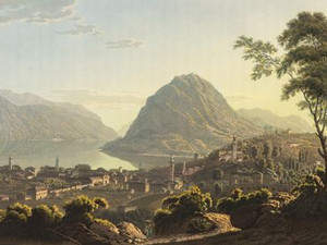
All travel guides of the time recommended staying at the Grande Auberge des Suisses (l'Albergo svizzero) in Lugano, which was known as the best hostel in Switzerland. Due to its location near the St. Gotthard, Lugano was a trading and business center, especially for the production of tobacco, wool and silk. There were a number of silk spinning mills in Lugano, and the silk was even finer than that of Milan.


Aufnahmestandort
nb-481668
Ort auf moderner Karte
GEOMETRYCOLLECTION (POINT (8.945768 46.000877), LINESTRING (8.945768 46.000877, 8.945822 46.000575))
Camera Settings (3D)
{"landscape":{"image.scale":26,"viewpoint":{"bounds":[[8.924803727753073,46.00162564836302],[8.96568630461033,46.0222413818955]],"bearing":168.42042124347245,"pitch":83.52374394227833,"zoom":19.943638610713766,"center":{"lng":8.94570283591895,"lat":46.00110688689719},"cam":{"center":{"lng":8.956632251787283,"lat":46.01281319451209},"zoom":14.11821673033057,"bearing":0},"cameraToCenterDistance":1470.7493089575862,"cameraPosition":{"lngLat":{"lng":8.945498301161109,"lat":46.00180029180194},"altitude":367.79212679449614},"cameraTargetElevation":358.85779418945486}},"portrait":{"image.scale":25,"viewpoint":{"bounds":[[8.92480372647421,46.00162564836259],[8.965686305764308,46.02224138310717]],"bearing":168.42042124347245,"pitch":83.52374394227833,"zoom":19.943638610713766,"center":{"lng":8.945702835917473,"lat":46.00110688689668},"cameraToCenterDistance":1470.7493089575862,"cameraPosition":{"lngLat":{"lng":8.945498301159631,"lat":46.00180029180146},"altitude":367.7921267944962},"cameraTargetElevation":358.85779418945486}},"square":{"image.scale":26,"viewpoint":{"bounds":[[8.924803727785644,46.00162564836194],[8.965686304577389,46.022241381877706]],"bearing":168.42042124347245,"pitch":83.52374394227833,"zoom":19.943638610713766,"center":{"lng":8.945702835918382,"lat":46.001106886896196},"cam":{"center":{"lng":9.12921661174451,"lat":46.02612930258698},"zoom":10.104223155201518,"bearing":0},"cameraToCenterDistance":1470.7493089575862,"cameraPosition":{"lngLat":{"lng":8.94549830116054,"lat":46.001800291800976},"altitude":367.79212679449626},"cameraTargetElevation":358.85779418945486}}}
Quellen

Voyage pittoresque aux Lacs Majeur et de Lugano, Zurich 1828, p. 36; Johann Gottfried Ebel, Manuel du voyageur en Suisse, Zurich 1818, p. 36; p. 116

Bilder
nb-481669
Titel
View of Lugano drawn at the foot of San Salvatore
Text

The lakeside of Lugano presents itself above the road to Melide. In the foreground we see the foot of Monte San Salvatore. Johann Gottfried Ebel tells us the following about this area: "The vipers live here in such large numbers that the inhabitants of a house standing there were forced to leave it. In summer, they swim in droves to the cool forests on the other bank; in winter, they return to the foot of the Salvador and roll into each other in such a way that they form balls that are only studded with heads."


Aufnahmestandort
nb-481669
Ort auf moderner Karte
GEOMETRYCOLLECTION (POINT (8.95066 45.989896), LINESTRING (8.95066 45.989896, 8.951245 45.991077))
Camera Settings (3D)
{"landscape":{"image.scale":30,"viewpoint":{"bounds":[[8.924220348183297,45.98918218543636],[8.97898168904257,46.015804594663166]],"bearing":-9.73536589761386,"pitch":77.53023886448462,"zoom":19.222019288617854,"center":{"lng":8.950658887629743,"lat":45.98999981210244},"cam":{"center":{"lng":8.966303571767355,"lat":46.003629734311716},"zoom":13.749567581234064,"bearing":0},"cameraToCenterDistance":1470.7493089575862,"cameraPosition":{"lngLat":{"lng":8.95093810148444,"lat":45.98886909583567},"altitude":313.7389466587346},"cameraTargetElevation":285.5289062500003}},"portrait":{"image.scale":30,"viewpoint":{"bounds":[[8.92422034825384,45.98918218543619],[8.978981689005224,46.015804594603935]],"bearing":-9.73536589761386,"pitch":77.53023886448462,"zoom":19.222019288617854,"center":{"lng":8.950658887628947,"lat":45.98999981210224},"cameraToCenterDistance":1470.7493089575862,"cameraPosition":{"lngLat":{"lng":8.950938101483644,"lat":45.9888690958355},"altitude":313.73894665873473},"cameraTargetElevation":285.5289062500003}},"square":{"viewpoint":{"bounds":[[8.924220348156638,45.989182185435965],[8.978981689026654,46.0158045946564]],"bearing":-9.73536589761386,"pitch":77.53023886448462,"zoom":19.222019288617854,"center":{"lng":8.950658887628833,"lat":45.989999812101956},"cam":{"center":{"lng":9.198027052506774,"lat":46.021511076432944},"zoom":9.68255151367109,"bearing":0},"cameraToCenterDistance":1470.7493089575862,"cameraPosition":{"lngLat":{"lng":8.95093810148353,"lat":45.988869095835184},"altitude":313.7389466587349},"cameraTargetElevation":285.5289062500003},"image.scale":31}}
Quellen

Johann Gottfried Ebel, Anleitung, auf die angehmste und nützlichste Weise die Schweitz zu bereisen, vol. 3, Zurich 1810, pp. 371-372

Bilder
nb-481670
Titel
View from San Martino
Text

This rocky headland belonged to Campione and therefore to the Kingdom of Italy until 1863. However, the Lugano gallows were located here on the rock in front of St. Martin's Chapel, where the last person sentenced to death was hanged in 1804.


Aufnahmestandort
nb-481670
Ort auf moderner Karte
GEOMETRYCOLLECTION (POINT (8.955236 45.982547), LINESTRING (8.955236 45.982547, 8.959667 45.983671))
Camera Settings (3D)
{"landscape":{"camera.fov":55,"viewpoint":{"bounds":[[8.849252548713878,45.982022340331554],[9.382998032278408,46.22036019299898]],"bearing":20.39443449111809,"pitch":78.3300858772433,"zoom":16.976408170682898,"center":{"lng":8.95706534385431,"lat":45.98576192428786},"cam":{"center":{"lng":9.247986029344332,"lat":46.111478038839124},"zoom":10.584691122389248,"bearing":0},"cameraToCenterDistance":1228.4680701980606,"cameraPosition":{"lngLat":{"lng":8.954779239102578,"lat":45.9814892209441},"altitude":375.02504061192144},"cameraTargetElevation":270.3374999999997},"image.scale":39},"portrait":{"image.scale":78,"viewpoint":{"bounds":[[8.827989466564588,45.981284781340776],[9.467001435373817,46.26651034370738]],"bearing":20.39443449111809,"pitch":78.3300858772433,"zoom":16.716717172584644,"center":{"lng":8.957065343854765,"lat":45.98576192428726},"cameraToCenterDistance":1228.4680701980606,"cameraPosition":{"lngLat":{"lng":8.954328368376707,"lat":45.98064650983858},"altitude":395.671753080449},"cameraTargetElevation":270.3374999999997}},"square":{"image.scale":85,"viewpoint":{"bounds":[[8.925140726771644,45.9812786171363],[9.076598105301144,46.049942987305315]],"bearing":20.39443449111809,"pitch":72.02739992683006,"zoom":17.248426164559568,"center":{"lng":8.956252634530074,"lat":45.98423739804963},"cam":{"center":{"lng":9.682427619419315,"lat":46.06818716656042},"zoom":8.214869327783735,"bearing":0},"cameraToCenterDistance":1228.4680701980606,"cameraPosition":{"lngLat":{"lng":8.954413745094143,"lat":45.980800466258444},"altitude":402.5967149605382},"cameraTargetElevation":270.3374999999997}}}
Quellen

Vanessa Giannò, Pazzallo, in: Historical Dictionary of Switzerland (HLS), version of 27.07.2023, translated from Italian. [31.05.2024]

Bilder
nb-481671
Titel
View of Bissone
Text

Bissone today lies next to the Melide dam, which was built in 1847. Before that, its inhabitants enjoyed a certain prosperity from fishing. They sold the fish together with the catches from Morcote and Melide in Lugano. The traffic from Como to Lugano was transferred to ships here. Bissone used to be known for its sculptors and architects, many of whom moved south from here and worked in Rome, among other places. Carlo Maderno (around 1556-1629), for example, built the west façade of St. Peter's Basilica. However, the city's most famous son is certainly Francesco Borromini (1599-1667), whose church San Carlo alle Quattro Fontane in Rome, for example, had a decisive influence on Baroque architecture.


Aufnahmestandort
nb-481671
Ort auf moderner Karte
GEOMETRYCOLLECTION (POINT (8.963913 45.941992), LINESTRING (8.963913 45.941992, 8.963889 45.942342))
Camera Settings (3D)
{"landscape":{"image.scale":28,"viewpoint":{"bounds":[[8.917896038031529,45.91529000640071],[8.99268854500184,45.94137046347774]],"bearing":-1.7407728591933849e-9,"pitch":82.03011396154668,"zoom":19.310692351387488,"center":{"lng":8.963929116728764,"lat":45.94209736738077},"cam":{"center":{"lng":8.971343142490923,"lat":45.929572230735715},"zoom":13.622984500242609,"bearing":0},"cameraToCenterDistance":1228.4680701980606,"cameraPosition":{"lngLat":{"lng":8.963929116728877,"lat":45.941182596235365},"altitude":289.9670194297773},"cameraTargetElevation":275.7261108397735}},"portrait":{"image.scale":26,"viewpoint":{"bounds":[[8.917896039865298,45.91529000743765],[8.992688543904535,45.941370463476204]],"bearing":-5.222432264417876e-9,"pitch":82.03011396190537,"zoom":19.310692351323002,"center":{"lng":8.96392911672956,"lat":45.94209736737935},"cameraToCenterDistance":1228.4680701980606,"cameraPosition":{"lngLat":{"lng":8.963929116729645,"lat":45.94118259623389},"altitude":289.9670194297774},"cameraTargetElevation":275.7261108397735}},"square":{"image.scale":26,"viewpoint":{"bounds":[[8.931338900075332,45.92284824483363],[8.98429004039184,45.94131137280357]],"bearing":-2.4546125132474113e-9,"pitch":82.03271929627851,"zoom":19.80646033101285,"center":{"lng":8.963929116725922,"lat":45.94182691738672},"cam":{"center":{"lng":9.196094601657961,"lat":45.950491559953235},"zoom":9.731047532740574,"bearing":0},"cameraToCenterDistance":1228.4680701980606,"cameraPosition":{"lngLat":{"lng":8.96392911672595,"lat":45.94117817053183},"altitude":285.82230533450866},"cameraTargetElevation":275.7261108397735}}}
Quellen

Antonio Gili, Bissone, in: Historisches Lexikon der Schweiz (HLS), version of 27.07.2023, translated from Italian. [31.05.2024]; http://www.tessinerkuenstler-ineuropa.ch/deu/bissone-deu.html [31.05.2024]; Voyage pittoresque aux Lacs Majeur et de Lugano, Zurich 1828, no p.

Bilder
nb-481672
Titel
View from Maroggia in the direction of Capo Lago
Text

The inhabitants of the small village of Maroggio were known above all for their skills in silkworm rearing. In the far background we see Capolago at the southern end of Lago di Lugano.


Aufnahmestandort
nb-481672
Ort auf moderner Karte
GEOMETRYCOLLECTION (POINT (8.968189 45.938293), LINESTRING (8.968189 45.938293, 8.968481 45.937512))
Camera Settings (3D)
{"landscape":{"image.scale":33,"viewpoint":{"bounds":[[8.943809933140301,45.91698073656457],[8.99360903489071,45.93888421239123]],"bearing":164.01840951404668,"pitch":73.99756281335054,"zoom":19.390277763822727,"center":{"lng":8.968195170156605,"lat":45.93830208721593},"cam":{"center":{"lng":8.980789677914942,"lat":45.92886716233346},"zoom":14.03299067597196,"bearing":0},"cameraToCenterDistance":1107.646491440297,"cameraPosition":{"lngLat":{"lng":8.96789520834733,"lat":45.93903045147641},"altitude":297.1707159405465},"cameraTargetElevation":273.0093444824219},"camera.fov":60},"portrait":{"image.scale":33,"viewpoint":{"bounds":[[8.943878623971045,45.91438883933361],[8.99645565733016,45.93889046053093]],"bearing":160.8184095114946,"pitch":74.49758352397392,"zoom":19.39027906763182,"center":{"lng":8.968195170165359,"lat":45.93830208720752},"cameraToCenterDistance":1107.646491440297,"cameraPosition":{"lngLat":{"lng":8.96783632884808,"lat":45.93901943444416},"altitude":296.4345581531592},"cameraTargetElevation":273.0093444824219}},"square":{"image.scale":37,"camera.fov":60,"viewpoint":{"bounds":[[8.950572661309735,45.92050178722312],[8.989215012257006,45.93888369081549]],"bearing":160.01840951571444,"pitch":71.65748819673455,"zoom":19.37188367413679,"center":{"lng":8.968195170164222,"lat":45.93830208720891},"cam":{"center":{"lng":9.143784416046145,"lat":45.94313053323282},"zoom":10.185526417686331,"bearing":0},"cameraToCenterDistance":1107.646491440297,"cameraPosition":{"lngLat":{"lng":8.967822831665472,"lat":45.93901421618827},"altitude":300.944340157212},"cameraTargetElevation":273.0093444824219}}}
Quellen

Voyage pittoresque aux Lacs Majeur et de Lugano, Zurich 1828, no p.

Johann Gottfried Ebel, Anleitung, auf die nüzlichste und genussvollste Art die Schweitz bereisen, vol. 3, Zurich 1810, pp. 259; 371; Rebecca Gericke-Budliger: "Johann Jakob Wetzel". In: SIKART Lexikon zur Kunst in der Schweiz, 2019 (first published in 1998) [23.02.2024]; "Conrad Caspar Rordorf". In: SIKART Lexikon zur Kunst in der Schweiz [10.06.2024]

Download the entire document as PDF

Bitte berühren!