EN Urban development in the views of the Kleinmeister

From Bastion to Railway Station
Bilder
SFF_D_1243
Titel
St. Gallen from the Zürcher Strasse around 1780
Text

Where are larger settlements built? Most likely in a place where many people and goods come together anyway and where there is enough water for the inhabitants to drink and to power mills and other commercial enterprises. Most towns are located on rivers, lakes or at the crossroads of major roads. In St. Gallen, however, everything was a little different. The town is located far away from any major traffic and trade routes in the high valley of the Steinach, a small mountain stream. The monastery, which was founded in the middle of the forest in 719 and attracted many pilgrims, gave rise to the town's development. The urban settlement grew in a circular shape to the north of the monastery in the High Middle Ages. In the course of the 13th century, legal structures also developed that turned St. Gallen into a city, with the citizens organizing themselves in a council, creating a municipal court and taking over care of the poor and sick with a hospital.

The French archaeologist and traveller Desiré Raoul Rochette (1789-1854) describes St. Gallen as follows:

"When you move from the canton of Appenzell to the canton of St. Gallen, you see once again how the appearance of the places and nature change, but it is above all the genius of man that has brought about this sudden metamorphosis. Instead of wooden houses isolated from each other and scattered without order over the undulating ground, it is a brick town with numerous houses so close together that they seem to stand in a space too small to contain them all. Instead of the green turf that forms the entire floor of the Appenzellerland, it is a landscape entirely covered with bright white cloth, and these two cantons, so close together, have in common only the extreme cleanliness that adorns all their houses."


Ort auf moderner Karte
GEOMETRYCOLLECTION (POINT (9.365405 47.420347), LINESTRING (9.365405 47.420347, 9.374042 47.42306))
Camera Settings (3D)
{"landscape":{"viewpoint":{"bounds":[[9.364752832908493,47.35718990373306],[9.744604469751692,47.600826099308335]],"bearing":65.336749753812,"pitch":82.81846840240426,"zoom":18.00756112314554,"center":{"lng":9.36841294169426,"lat":47.42124957534912},"cam":{"center":{"lng":9.644910074301947,"lat":47.48592474946855},"zoom":11.132004349952725,"bearing":0},"cameraToCenterDistance":1918.5,"cameraPosition":{"lngLat":{"lng":9.36379748480934,"lat":47.41981563977919},"altitude":723.5649874086043},"cameraTargetElevation":675.4196289063315}},"portrait":{"image.scale":23,"viewpoint":{"bounds":[[9.20790989937018,47.347143924405515],[9.365055973314668,47.44909715881454]],"bearing":66.93674975381191,"pitch":85,"zoom":18.00756112314554,"center":{"lng":9.368412941705287,"lat":47.42124957534804},"cameraToCenterDistance":1918.5,"cameraPosition":{"lngLat":{"lng":9.363721084484837,"lat":47.419897914571095},"altitude":708.985177301366},"cameraTargetElevation":675.4196289063315}},"square":{"image.scale":35,"viewpoint":{"bounds":[[9.20790989940187,47.347143924341424],[9.365055973314611,47.449097158762754]],"bearing":66.93674975381191,"pitch":85,"zoom":18.00756112314554,"center":{"lng":9.368412941705515,"lat":47.42124957534759},"cam":{"center":{"lng":9.993640268965606,"lat":47.45130443188086},"zoom":8.161674962461671,"bearing":0},"cameraToCenterDistance":1918.5,"cameraPosition":{"lngLat":{"lng":9.363721084485121,"lat":47.41989791457064},"altitude":708.9851773013663},"cameraTargetElevation":675.4196289063315}}}
Quellen

Stefan Sonderegger; Marcel Mayer: "St. Gallen (municipality)", in: Historical Dictionary of Switzerland (HLS), Version vom 06.01.2012 [29.11.2024]; Desiré Raoul Rochette, Lettres sur la Suisse, écrites en 1820, suivies d'un voyage à Chamouny et au Simplon, Paris 1822, pp. 207-209

Bilder
nb-889663
Titel
St. Gallen from Rotmonten, 1817
Text

Canvas production, which brought prosperity to St. Gallen from the 15th century onwards, had a major impact on the townscape. Numerous 97.5 m long and approximately 1 m wide lengths of canvas were laid out for bleaching on large meadows to the west and east of the town throughout the summer. To become as pure white as possible, a length of fabric had to lie in the sun for several months and be regularly moistened with fresh water. The meadows where this was done were called "Bleichen".

Around 1800, canvas production and finishing was still an important branch of industry in St. Gallen, even though the cotton (mousseline) trade was beginning to overtake it:

"The widespread trade in mousseline and canvas, and the establishment of various families in foreign trading towns has brought the town much wealth and provided the bourgeoisie with good food. The number of its inhabitants is counted at around 8,000 souls."

Désiré Raoul Rochette (1789-1854) even compared St. Gallen favorably with the largest city in Switzerland at the time, Geneva:

"The most remarkable thing about St. Gallen is its uniform architecture, which testifies to an equality of circumstances and wealth that is very rare in trading cities. The general prosperity of the inhabitants is no less evident in their cleanliness [...] and in the extreme care they take in maintaining and beautifying their houses. Here, then, we have an industrial city of a very different character from Geneva, and it is not to be wondered at, after the so different appearance of these two cities equally devoted to trade, that the people of St. Gall are as sedentary as those of Geneva are vagabonds."

Ort auf moderner Karte
GEOMETRYCOLLECTION (POINT (9.385382 47.435108), LINESTRING (9.385382 47.435108, 9.376659 47.423057))
Camera Settings (3D)
{"landscape":{"image.scale":25,"viewpoint":{"bounds":[[9.385354637482436,47.435542481967985],[9.494296283191261,47.5050253768745]],"bearing":-150.9028931383151,"pitch":84.97925317456988,"zoom":18.50508691326032,"center":{"lng":9.38451960683119,"lat":47.433987862966944},"cam":{"center":{"lng":9.479257210896293,"lat":47.47325697000073},"zoom":12.326276527713363,"bearing":0},"cameraToCenterDistance":1918.5,"cameraPosition":{"lngLat":{"lng":9.386276053679723,"lat":47.4361227207294},"altitude":697.4655428281254},"cameraTargetElevation":673.5977539062507}},"portrait":{"image.scale":23,"viewpoint":{"bounds":[[9.385354637482806,47.43554248196904],[9.494296282917674,47.50502537666307]],"bearing":-150.9028931383151,"pitch":84.97925317456988,"zoom":18.50508691326032,"center":{"lng":9.38451960683176,"lat":47.4339878629678},"cameraToCenterDistance":1918.5,"cameraPosition":{"lngLat":{"lng":9.386276053680291,"lat":47.43612272073025},"altitude":697.4655428281251},"cameraTargetElevation":673.5977539062507}},"square":{"image.scale":25,"viewpoint":{"bounds":[[9.385354637482152,47.435542481970344],[9.494296283197428,47.50502537687646]],"bearing":-150.9028931383151,"pitch":84.97925317456988,"zoom":18.50508691326032,"center":{"lng":9.384519606830963,"lat":47.433987862969275},"cam":{"center":{"lng":9.930062866058478,"lat":47.50710328457069},"zoom":8.69022562484382,"bearing":0},"cameraToCenterDistance":1918.5,"cameraPosition":{"lngLat":{"lng":9.386276053679524,"lat":47.4361227207317},"altitude":697.4655428281244},"cameraTargetElevation":673.5977539062507}}}
Quellen

Marcel Mayer, "Canvas", in: Historisches Lexikon der Schweiz (HLS), version of 23.05.2012 [11.01.2025]; Heinrich Heidegger, Handbuch für Reisende durch die Schweiz, 2. Abschnitt, Zurich 1790, p. 51; Desiré Raoul Rochette, Lettres sur la Suisse, écrites en 1820, suivies d'un voyage à Chamouny et au Simplon, Paris 1822, pp. 207-209

Bilder
nb-888733
Titel
St. Gallen, 1818
Text

About 1720, the economic basis of St. Gallen began to change, which ultimately had an impact on the cityscape: linen processing was on the decline due to the rise of cotton. Instead of finishing locally produced canvas, entrepreneurs began to use the publishing system. This meant that they had tens of thousands of cottagers in the region making cloth from imported cotton and selling the products. One consequence of this was that the bleachers to the west and east of the city became less and less important. The great famine in the winter of 1816 and the following year dealt a fatal blow to these large open spaces, which had characterized the cityscape for more than 300 years. To support food security, the city council decided in 1818 to free up the Bleichen and convert them into plant gardens. These "Gemeindstheile" were free for use by the poorer population.

Ort auf moderner Karte
GEOMETRYCOLLECTION (POINT (9.361017 47.421492), LINESTRING (9.361017 47.421492, 9.374728 47.421857))
Camera Settings (3D)
{"landscape":{"viewpoint":{"bounds":[[9.152519734922976,47.35630401781813],[9.360740480840093,47.53476697746936]],"bearing":91.48823550094562,"pitch":85,"zoom":17.31823643952918,"center":{"lng":9.367207288746727,"lat":47.421271352827915},"cam":{"center":{"lng":9.357860828886885,"lat":47.45321744273423},"zoom":10.96605901412688,"bearing":0},"cameraToCenterDistance":1918.5,"cameraPosition":{"lngLat":{"lng":9.358987069376042,"lat":47.42141585128661},"altitude":724.4187413105071},"cameraTargetElevation":670.2933593748978}},"portrait":{"image.scale":37,"viewpoint":{"bounds":[[9.159997772798107,47.35879945823257],[9.360632752674547,47.53076325071177]],"bearing":91.48823550094562,"pitch":85,"zoom":17.37177709032178,"center":{"lng":9.366863965987818,"lat":47.421398387959755},"cameraToCenterDistance":1918.5,"cameraPosition":{"lngLat":{"lng":9.358943220370406,"lat":47.42153762181442},"altitude":721.5278089964912},"cameraTargetElevation":669.3744140625001}},"square":{"viewpoint":{"bounds":[[9.159997772804388,47.35879945830419],[9.360632752674462,47.53076325071683]],"bearing":91.48823550094562,"pitch":85,"zoom":17.37177709032178,"center":{"lng":9.366863965987818,"lat":47.42139838796061},"cam":{"center":{"lng":10.163172672154644,"lat":47.512652548696536},"zoom":7.8092080354883,"bearing":0},"cameraToCenterDistance":1918.5,"cameraPosition":{"lngLat":{"lng":9.35894322037035,"lat":47.421537621815276},"altitude":721.5278089964903},"cameraTargetElevation":669.3744140625001}}}
Quellen

Stefan Sonderegger; Marcel Mayer: "St. Gallen (municipality)", in: Historisches Lexikon der Schweiz (HLS), Version vom 06.01.2012 [29.11.2024]; Edgar Heilig, St. Gallen, in: Bernd Roeck, Martina Stercken, François Walter, Marco Jorio, Thomas Manetsch (eds.), Schweizer Städtebilder. Urbane Ikonographien (15.-20. Jahrhundert), Zurich 2013, pp. 491-496; Louis Specker, Die grosse Heimsuchung. Das Hungerjahr 1816/17 in der Ostschweiz (Neujahrsblatt des Historischen Vereins des Kantons St. Gallen, Zweiter Teil, Vol. 135), St. Gallen 1995, p. 31

Bilder
SFF_D_1262
Titel
St. Gallen between 1835 and 1850
Text

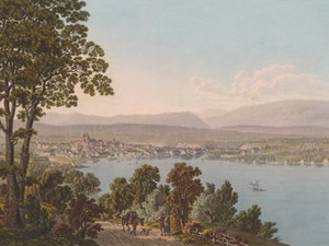
"St. Gall, capital of the canton, is situated in an elevated valley on the banks of a small stream called the Steinach, and has a population of 10,333 souls. It is one of the principal seats of manufacturing industry in Switzerland. The manufacture of muslins, known as Swiss muslins all over Europe, is the most flourishing; but the spinning of cotton is also rapidly increasing. There are extensive bleacheries in the town, and the neighbouring slopes are white with linen. The antique walls, however, which still surround the town, and the ditch, now converted into gardens, tell of a totally different period and state of society, and recall to mind the ancient history of St. Gall."

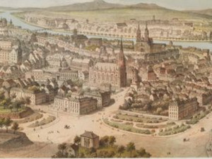
When John Murray (1808-1892) wrote these lines around 1839, the growth of St. Gall was in full swing. Between 1800 and 1850, the population of St. Gallen more than doubled, from just over 8,000 inhabitants to 17,858. This was initially reflected in the city's growth to the east and, after 1800, also to the west. In this view from Speicherstrasse, we can see the new buildings that were constructed on Linsebühlstrasse and Speicherstrasse between 1841 and 1854.

And this view also shows another development compared to the previous ones: between 1808 and 1839, ten city gates and towers were demolished, so that by 1850 only three of them were still standing. The city walls fell. From 1833, the ditches were filled in and transformed into elongated squares. The city was ready for further growth.

Ort auf moderner Karte
GEOMETRYCOLLECTION (POINT (9.387689 47.42496), LINESTRING (9.387689 47.42496, 9.379363 47.424839))
Camera Settings (3D)
{"landscape":{"viewpoint":{"bounds":[[9.261941446392655,47.38336824919571],[9.38817611475082,47.492175411835944]],"bearing":-87.59961135252036,"pitch":79.66702002564463,"zoom":17.660640488868975,"center":{"lng":9.383909404277802,"lat":47.42512401040571},"cam":{"center":{"lng":9.365455957642098,"lat":47.4408358968941},"zoom":12.291379805679474,"bearing":0},"cameraToCenterDistance":1918.5,"cameraPosition":{"lngLat":{"lng":9.39030865940353,"lat":47.42494252353927},"altitude":763.1947279647183},"cameraTargetElevation":675.3439697263459}},"portrait":{"image.scale":37,"viewpoint":{"bounds":[[9.275194249365455,47.390535014817004],[9.388185142366297,47.48827844675503]],"bearing":-87.59961135259893,"pitch":79.66732284699694,"zoom":17.660641879090146,"center":{"lng":9.383909404275073,"lat":47.42512401040628},"cameraToCenterDistance":1918.5,"cameraPosition":{"lngLat":{"lng":9.390308659400915,"lat":47.42494252353981},"altitude":763.1920967030845},"cameraTargetElevation":675.3439697263459}},"square":{"viewpoint":{"bounds":[[9.27519424911651,47.390535014723866],[9.38818514236658,47.48827844687307]],"bearing":-87.59961135259893,"pitch":79.66732284699694,"zoom":17.660641879090146,"center":{"lng":9.383909404275983,"lat":47.42512401040673},"cam":{"center":{"lng":9.84014871536678,"lat":47.477627335945954},"zoom":8.63757469107601,"bearing":0},"cameraToCenterDistance":1918.5,"cameraPosition":{"lngLat":{"lng":9.390308659401654,"lat":47.42494252354027},"altitude":763.1920967030837},"cameraTargetElevation":675.3439697263459}}}
Quellen

John Murray, The Hand-Book for Travellers in Switzerland, 2nd edition, London 1840, p. 234; Stefan Sonderegger; Marcel Mayer: "St. Gallen (municipality)", in: Historisches Lexikon der Schweiz (HLS), version of 06.01.2012 [29.11.2024]; Erwin Poeschel, Die Kunstdenkmäler des Kantons St. Gallen, Band II: Die Stadt St. Gallen, erster Teil, Basel 1957, S. 64

Bilder
zbz-990055662020205508
Titel
Zurich from the Enge, 1791
Text

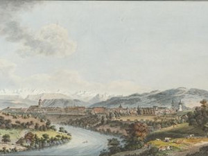
In contrast to the Steinach valley, the Limmat outflow on Lake Zurich meets all the requirements for the development of a town. This is where the route through the Swiss Plateau and the route across Lake Zurich to the Graubünden passes intersect. The location was therefore practically unavoidable. At the same time, there was plenty of water and land for settlement. It is therefore not surprising that the lower lake basin has been continuously inhabited for the last 7000 years. The roots of the settlement structure as it appears in the views of the Kleinmeister lie in the Middle Ages. The two early medieval monasteries Grossmünster and Fraumünster as well as the old imperial palace on the Lindenhof were the focal points of settlement development. Like so many cities, Zurich was given an institutional framework in the course of the 13th century, with a council and public institutions. The influence of the ecclesiastical centers of power waned. Economically, Zurich was dependent on long-distance trade at this time, but also on textile production. As one of the few cities north of the Alps, Zurich even briefly had a silk trade in the late Middle Ages. The introduction of the guild system in the 14th century meant a certain isolation of the city and heralded the end of an economic and cultural heyday. The work of the reformer Ulrich Zwingli (1484-1531) made Zurich the international center of the Reformed Church in the 16th century. After the crisis-ridden 15th century, the silk trade and commerce as well as cultural relations increased again. This was not least due to the settlement of religious refugees from Ticino and the southern valleys of Graubünden. During the 18th century, Zurich was a popular meeting place for German poets, scholars and artists in particular. Its nickname at this time was "Athens on the Limmat" in reference to the capital of ancient Greece.

Ort auf moderner Karte
GEOMETRYCOLLECTION (POINT (8.534124 47.36103), LINESTRING (8.534124 47.36103, 8.546462 47.369352))
Camera Settings (3D)
{"landscape":{"image.scale":35,"viewpoint":{"bounds":[[8.422909738704305,47.2890255517992],[8.5342805812206,47.360462560929136]],"bearing":28.72988875254282,"pitch":85,"zoom":18.441241334001948,"center":{"lng":8.53513777255921,"lat":47.362099583340495},"cam":{"center":{"lng":8.519024051365676,"lat":47.327800978093734},"zoom":12.29024764339838,"bearing":0},"cameraToCenterDistance":1918.5,"cameraPosition":{"lngLat":{"lng":8.533322972737096,"lat":47.35985699189072},"altitude":440.9131346436013},"cameraTargetElevation":416.03427734368597}},"portrait":{"image.scale":29,"viewpoint":{"bounds":[[8.420391634773011,47.2875207325267],[8.534208113639437,47.3605274494181]],"bearing":28.72988875254282,"pitch":85,"zoom":18.409903459879544,"center":{"lng":8.535084128379822,"lat":47.36220041722211},"cameraToCenterDistance":1918.5,"cameraPosition":{"lngLat":{"lng":8.53322947665339,"lat":47.35990858313389},"altitude":440.9130972011024},"cameraTargetElevation":415.48796386718743}},"square":{"viewpoint":{"bounds":[[8.42039163515264,47.28752073273381],[8.534208113641114,47.36052744941776]],"bearing":28.72988875254282,"pitch":85,"zoom":18.409903459879544,"center":{"lng":8.535084128381868,"lat":47.36220041722174},"cam":{"center":{"lng":8.98947402759498,"lat":47.3625979431217},"zoom":8.627071743304228,"bearing":0},"cameraToCenterDistance":1918.5,"cameraPosition":{"lngLat":{"lng":8.533229476655492,"lat":47.35990858313352},"altitude":440.9130972011026},"cameraTargetElevation":415.48796386718743}}}
Quellen

Carl Gottlob Küttner, Briefe eines Sachsen aus der Schweiz an einen Freund in Leipzig, Leipzig 1785/86, p. 203; Nicola Behrens; Andreas Motschi; Max Schultheiss: "Zurich (municipality)", in: Historical Dictionary of Switzerland (HLS), version of 25.01.2015 [29.11.2024]

Bilder
nb-481636
Titel
Zurich from the Bastion zur Katz, 1819
Text

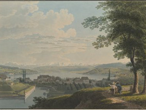
"Zurich, the city, [...] lies [...] on the Limmat, which leaves Lake Zurich here and divides the city into two unequal parts, connected again by three wooden bridges. In addition, two canals with running water, one from the Sihl, the other (Fröschengraben) from the lake, run through the city. It contains 1173 houses and 102 other buildings, and 10,371 inhabitants (including the absent citizens, but not counting foreign journeymen, servants, garrison and convicts, which together would probably make a total of 14,000 souls), of whom 7,367 are naturalized citizens. Its extensive fortifications are dominated by several nearby hills."

"[...] The cleanliness that is popular in the apartments is seen less in the narrow, uneven, poorly paved streets. In addition, the air is spoiled by the accumulation of impurities, which are otherwise removed as quickly as possible; the burial grounds, which are not spacious, are also mostly located inside the ring walls."

In addition to the medieval curtain walls, the Baroque ramparts were added in the 17th century. Johann Jakob Wetzel took this view from one of these redoubts, which was called "zur Katz". In front of it we can still see the extensive waterworks, which by this time had already cut up the suburb and were no longer of any defensive significance. The chatting lovers in the foreground also show that all the huge structures were increasingly used for recreation.


Ort auf moderner Karte
GEOMETRYCOLLECTION (POINT (8.533609 47.371099), LINESTRING (8.533609 47.371099, 8.533737 47.370897))
Camera Settings (3D)
{"landscape":{"viewpoint":{"bounds":[[8.316165118868867,47.371332276411636],[8.56756085233323,47.56854309843416]],"bearing":148.43114322529334,"pitch":85,"zoom":17.157619118485172,"center":{"lng":8.536961674692634,"lat":47.36771146790355},"cam":{"center":{"lng":8.553780142702635,"lat":47.47843543545915},"zoom":10.821274971644327,"bearing":0},"cameraToCenterDistance":1918.5,"cameraPosition":{"lngLat":{"lng":8.532149778832263,"lat":47.373015172716094},"altitude":476.83023533287894},"cameraTargetElevation":416.26923824380896}},"portrait":{"viewpoint":{"bounds":[[8.310472153157775,47.37195577586195],[8.567574117575901,47.57363195261675]],"bearing":148.43114322529334,"pitch":85,"zoom":17.12523865282723,"center":{"lng":8.536280393600464,"lat":47.36825282241119},"cameraToCenterDistance":1918.5,"cameraPosition":{"lngLat":{"lng":8.531359276366942,"lat":47.37367684991173},"altitude":476.8295182675183},"cameraTargetElevation":414.8945312499999}},"square":{"viewpoint":{"bounds":[[8.315358727404458,47.37133125428795],[8.567692315418242,47.5692718762194]],"bearing":148.43114322544457,"pitch":84.9960610113275,"zoom":17.157610437679853,"center":{"lng":8.536961674693657,"lat":47.36771146790335},"cam":{"center":{"lng":9.57702666747349,"lat":47.55561066375904},"zoom":7.478448935613261,"bearing":0},"cameraToCenterDistance":1918.5,"cameraPosition":{"lngLat":{"lng":8.532149778833286,"lat":47.373015172715895},"altitude":475.5034815278947},"cameraTargetElevation":414.8945312499999}}}
Quellen

Heinrich Heidegger, Handbuch für Reisende in der Schweiz, 4th edition, Zurich 1818, p. 485; Robert Glutz von Blotzheim, Heinrich Heidegger, Handbuch für Reisende in der Schweiz, 5th edition, Zurich 1823, p. 496

Bilder
nb-477320
Titel
Zurich from the Beckenhof, 1837
Text

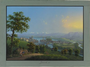
Louis Bleuler's view of the city from Beckenhof shows its location on the Limmat to particularly good advantage. In the first half of the 19th century, Zurich had yet to experience its great growth spurt. Most of the baroque fortifications were still in place and the bridges over the Limmat were made of wood. Only the lakeside fortifications have disappeared. On the Mühlesteg, the foremost bridge over the Limmat, you can even still see the residential buildings and industrial plants that shaped this part of the cityscape for centuries.


Ort auf moderner Karte
GEOMETRYCOLLECTION (POINT (8.541639 47.38449), LINESTRING (8.541639 47.38449, 8.541639 47.384348))
Camera Settings (3D)
{"landscape":{"image.scale":16,"viewpoint":{"bounds":[[8.507470286537256,47.38478665492204],[8.604255391953444,47.436799126443475]],"bearing":-177.76403601656546,"pitch":84.99561004583175,"zoom":18.77065666145834,"center":{"lng":8.541650176048279,"lat":47.38319056095244},"cam":{"center":{"lng":8.585346711473903,"lat":47.41301624638288},"zoom":12.745708276067656,"bearing":0},"cameraToCenterDistance":1918.5,"cameraPosition":{"lngLat":{"lng":8.541767405543396,"lat":47.38522344879436},"altitude":452.96357892144357},"cameraTargetElevation":433.1541015625007}},"portrait":{"image.scale":16,"viewpoint":{"bounds":[[8.506109268784712,47.384834647496746],[8.606520433670227,47.43879472184088]],"bearing":-177.76403601656546,"pitch":84.99561004583175,"zoom":18.71759386678101,"center":{"lng":8.541569709777832,"lat":47.383178756288174},"cameraToCenterDistance":1918.5,"cameraPosition":{"lngLat":{"lng":8.54169133128687,"lat":47.38528780540935},"altitude":452.9635599200133},"cameraTargetElevation":432.4119140625735}},"square":{"image.scale":16,"viewpoint":{"bounds":[[8.506109267590574,47.38483464749268],[8.606520435945356,47.43879472366265]],"bearing":-177.76403601656546,"pitch":84.99561004583175,"zoom":18.71759386678101,"center":{"lng":8.541569709778969,"lat":47.383178756283485},"cam":{"center":{"lng":9.008165109364484,"lat":47.44578596539756},"zoom":8.8078614474866,"bearing":0},"cameraToCenterDistance":1918.5,"cameraPosition":{"lngLat":{"lng":8.541691331287979,"lat":47.38528780540466},"altitude":452.96355992001514},"cameraTargetElevation":432.4119140625735}}}
Bilder
zbz-990056410630205508
Titel
Opening of the new Münsterbrücke on August 20, 1838
Text

Before Zurich grew outwards, the urban structure within the city walls was improved. This included the construction of the new Münsterbrücke bridge in 1836-38 to replace the old wooden "Oberer Steg". At its opening, it shone together with the surrounding buildings in grandiose fireworks.

"The two banks of the Limmat are connected by two bridges fit for carriages and two footbridges for pedestrians. Of these, the new Münsterbrücke made of stone deserves a more detailed mention. It consists of four slightly shallow arches, whose piers rest on close to 500 piles, which were driven 14 to 54 feet long into the not everywhere favorable ground of the river bed. [...] The vault and lining are made of black marble from the quarries at Lake Walen; the main cornice is made of whitish Gotthard granite, which was gained in Mellingen from immense erratic blocks. The sidewalks and the double lanes attached to the roadways are of the same granite, the middle of which is studded with decapitated pebbles. [...] The strong cast-iron railing (which, however, does not harmonize with the other bridge shapes in Gothic taste) was cast in Zizenhausen near Stockach, Grand Duchy of Baden. [...] This beautiful structure was built by the Zurich merchants, under the direction of engineer Negrelli, by the Zurich master builders Conrad Stadler, C. Locher and J. Staub and was ceremoniously inaugurated on August 20, 1838 and handed over to the city council by the government."


Ort auf moderner Karte
GEOMETRYCOLLECTION (POINT (8.542256 47.37156), LINESTRING (8.542256 47.37156, 8.542449 47.37002))
Camera Settings (3D)
{"landscape":{"camera.fov":56,"image.scale":36,"viewpoint":{"bounds":[[8.517917379133422,47.37205166924673],[8.57000679221855,47.39316156768851]],"bearing":170.6696250946308,"pitch":85,"zoom":17.717709503416703,"center":{"lng":8.542728424072266,"lat":47.369889568509734},"cam":{"center":{"lng":8.555922075705325,"lat":47.38350745651127},"zoom":14.047418100739316,"bearing":0},"cameraToCenterDistance":1202.7245745889793,"cameraPosition":{"lngLat":{"lng":8.542094793377402,"lat":47.37250138851712},"altitude":430.249894697835},"cameraTargetElevation":404.5}},"portrait":{"image.scale":41,"viewpoint":{"bounds":[[8.517917379151953,47.37205166924619],[8.570006792153663,47.39316156763232]],"bearing":170.6696250946308,"pitch":85,"zoom":17.717709503416703,"center":{"lng":8.542728424072607,"lat":47.36988956850902},"cameraToCenterDistance":1202.7245745889793,"cameraPosition":{"lngLat":{"lng":8.542094793377828,"lat":47.37250138851638},"altitude":430.2498946978353},"cameraTargetElevation":404.5}},"square":{"image.scale":43,"viewpoint":{"bounds":[[8.51791737923918,47.37205166924571],[8.570006792120125,47.39316156760103]],"bearing":170.6696250946308,"pitch":85,"zoom":17.717709503416703,"center":{"lng":8.542728424072834,"lat":47.369889568508654},"cam":{"center":{"lng":8.778364443644051,"lat":47.40023958023812},"zoom":9.754719110073037,"bearing":0},"cameraToCenterDistance":1202.7245745889793,"cameraPosition":{"lngLat":{"lng":8.542094793377998,"lat":47.372501388515985},"altitude":430.2498946978355},"cameraTargetElevation":404.5}}}
Quellen

Gottfried von Escher, Zürich und seine Umgebungen. Ein Almanach für Einheimische und Fremde, Zurich 1839, p. 33

Bilder
zbz-990052192590205508
Titel
A bird's eye view of Zurich from the northwest around 1848
Text

Now the big growth begins. Click on "Image details" to see everything that has happened in Zurich up to 1848.

Ort auf moderner Karte
GEOMETRYCOLLECTION (POINT (8.534317 47.382684), LINESTRING (8.534317 47.382684, 8.535433 47.380649))
Camera Settings (3D)
{"landscape":{"viewpoint":{"bounds":[[8.519108271157307,47.27449206072882],[8.645690549630075,47.38392896947511]],"bearing":152.05489833028594,"pitch":80.52707261708638,"zoom":17.422940097100284,"center":{"lng":8.536406457423482,"lat":47.37994871922746},"cam":{"center":{"lng":8.644339130213694,"lat":47.333903296088096},"zoom":11.674769430448915,"bearing":0},"cameraToCenterDistance":2386.6464914402973,"cameraPosition":{"lngLat":{"lng":8.53199221875542,"lat":47.38558298175758},"altitude":531.3604001228539},"cameraTargetElevation":413.01970214868027}},"portrait":{"viewpoint":{"bounds":[[6.1091503827501015,47.38371753963892],[8.818847756595773,49.6943072860432]],"bearing":152.05489833028582,"pitch":85,"zoom":17.422940097100284,"center":{"lng":8.536406457423027,"lat":47.379948719228565},"cameraToCenterDistance":2386.6464914402973,"cameraPosition":{"lngLat":{"lng":8.531948221430355,"lat":47.38563913619842},"altitude":475.68815266340573},"cameraTargetElevation":413.01970214868027}},"square":{"viewpoint":{"bounds":[[8.519115892771907,47.27455128271629],[8.645629797638321,47.3839285418436]],"bearing":152.05489832965486,"pitch":80.52260895119562,"zoom":17.422921338854703,"center":{"lng":8.536406457425983,"lat":47.379948719227},"cam":{"center":{"lng":9.151685417104005,"lat":47.372125385270294},"zoom":8.474485234128469,"bearing":0},"cameraToCenterDistance":2386.6464914402973,"cameraPosition":{"lngLat":{"lng":8.531992218757978,"lat":47.385582981757125},"altitude":531.4171925808768},"cameraTargetElevation":413.01970214868027}}}
Bilder
zbz-990053884510205508
Titel
Zurich from the old botanical garden around 1850
Text

A good 30 years have passed since the last view from this point. Compare the two and note what differences you can see!

In 1837, the old bastion "zur Katz" became the botanical garden of the University of Zurich. The Palm House with its large glass windows in cast iron frames was built there in 1851. Even today, the Old Botanical Garden, as it is now called, provides a popular oasis of calm in the middle of Zurich's city center. Its use as a garden has also meant that the bastion is the only part of the fortifications that has not been leveled and is still preserved today. The Schanzengraben also still exists as a secluded watercourse.

Ort auf moderner Karte
GEOMETRYCOLLECTION (POINT (8.533652 47.371018), LINESTRING (8.533652 47.371018, 8.534489 47.370204))
Camera Settings (3D)
{"landscape":{"viewpoint":{"bounds":[[8.282928992840795,47.37107340850187],[8.533540600518364,47.573140055073765]],"bearing":134.28239271091107,"pitch":84.46556473829202,"zoom":17.993976514649265,"center":{"lng":8.535963892936707,"lat":47.369663406285156},"cam":{"center":{"lng":8.483034279080357,"lat":47.4778213881892},"zoom":11.402606000594878,"bearing":0},"cameraToCenterDistance":1918.5,"cameraPosition":{"lngLat":{"lng":8.532281795778971,"lat":47.37209541084016},"altitude":456.21418496736584},"cameraTargetElevation":418.68342285153864}},"portrait":{"viewpoint":{"bounds":[[8.281877399296945,47.371073531336606],[8.53331800770377,47.573807303687204]],"bearing":134.28239271091107,"pitch":84.46556473829202,"zoom":17.989212049415485,"center":{"lng":8.535749316215515,"lat":47.36965886486507},"cameraToCenterDistance":1918.5,"cameraPosition":{"lngLat":{"lng":8.53205503892039,"lat":47.372098914356684},"altitude":456.21419201654294},"cameraTargetElevation":418.55927734341526}},"square":{"viewpoint":{"bounds":[[8.281877408459593,47.37107353133621],[8.533318007703826,47.573807293288354]],"bearing":134.28239271091107,"pitch":84.46556473829202,"zoom":17.989212049415485,"center":{"lng":8.53574931621506,"lat":47.369658864865414},"cam":{"center":{"lng":9.539080404680789,"lat":47.55744929187634},"zoom":7.483563575669721,"bearing":0},"cameraToCenterDistance":1918.5,"cameraPosition":{"lngLat":{"lng":8.532055038919964,"lat":47.372098914357},"altitude":456.2141920165427},"cameraTargetElevation":418.55927734341526}}}
Bilder
zbz-990052197700205508
Titel
The Wipkingen viaduct around 1858
Text

The opening of the first railroad line from Zurich to Baden in 1847 introduced new elements to the cityscape that are still characteristic today. Large accompanying structures were required for the railway lines, such as the embankment over which the Nordostbahn line, completed in 1857, ran to Oerlikon and on to Winterthur and Romanshorn as well as westwards to Aarau. By 1900, the track field in the north-west of the city was to become ever wider and determine the appearance and growth of the industrial area.

Ort auf moderner Karte
GEOMETRYCOLLECTION (POINT (8.526742 47.39193), LINESTRING (8.526742 47.39193, 8.526818 47.391683))
Camera Settings (3D)
{"landscape":{"camera.fov":57,"viewpoint":{"bounds":[[8.057132480006146,47.39163133523152],[8.948264364357982,47.79038580454966]],"bearing":163.47258221295496,"pitch":80.52705464258212,"zoom":17.166087277704605,"center":{"lng":8.528022518589154,"lat":47.38917715776353},"cam":{"center":{"lng":8.693939839986342,"lat":47.6057170313629},"zoom":10.048311186130054,"bearing":0},"cameraToCenterDistance":1177.8124816183965,"cameraPosition":{"lngLat":{"lng":8.526442430635882,"lat":47.39278209131044},"altitude":476.7644116369326},"cameraTargetElevation":406.99462855225414}},"portrait":{"viewpoint":{"bounds":[[8.041691330031313,47.39195729642708],[8.961490813408233,47.80348666516184]],"bearing":163.47258221295496,"pitch":80.52705464258212,"zoom":17.120406840968435,"center":{"lng":8.527729837189867,"lat":47.38942418213472},"cameraToCenterDistance":1177.8124816183965,"cameraPosition":{"lngLat":{"lng":8.526098917996705,"lat":47.39314506442767},"altitude":477.2486851767474},"cameraTargetElevation":405.23475406030224}},"square":{"viewpoint":{"bounds":[[8.054325327689924,47.39163095993797],[8.950784835230934,47.79275694544884]],"bearing":163.47258221302596,"pitch":80.52270703029195,"zoom":17.166069007257406,"center":{"lng":8.528022518588614,"lat":47.389177157765005},"cam":{"center":{"lng":12.536622865395003,"lat":47.893990786655536},"zoom":5.649542772193779,"bearing":0},"cameraToCenterDistance":1177.8124816183965,"cameraPosition":{"lngLat":{"lng":8.526442430635342,"lat":47.392782091311915},"altitude":476.79702398668314},"cameraTargetElevation":406.99462855225414}}}
Bilder
zbz-990101099480205508
Titel
The quays in Zurich in July 1887
Text

The bird's eye view from the west illustrates the changes to the cityscape on the lake side too. In the 1880s in particular, the municipalities of Enge and Riesbach joined forces with the city to fill in large stretches of the lake basin and create the quays. These provided space for new public parks. On the left-hand edge of the picture, we can already see the street squaring north of the General-Guisan-Quai, where a spacious quarter with upscale perimeter block development and the new Tonhalle will be built in the years around 1900.

In 1893, Zurich's population was still smaller than that of Basel, Bern, Lausanne and Geneva. The city center had just 28,000 inhabitants, compared to around 10,000 in 1800, while the population of the city's eleven suburbs had increased from 7,000 to 79,000 in the same period. For the suburbs, this meant a heavy financial burden and the infrastructure could not keep pace with the strong growth everywhere. In 1893, a petition from the municipality of Aussersihl led to a referendum on the incorporation of the suburbs into the municipality of Zurich, which was approved by the majority of the municipalities. This first incorporation came into force in the same year and made Zurich the largest city in Switzerland with 107,000 inhabitants.

Ort auf moderner Karte
GEOMETRYCOLLECTION (POINT (8.498245 47.345218), LINESTRING (8.498245 47.345218, 8.54029 47.36554))
Camera Settings (3D)
{"landscape":{"camera.fov":30,"image.scale":65,"viewpoint":{"bounds":[[8.503907577055656,47.31263548816884],[8.961070005339451,47.558711481958795]],"bearing":63.31773169556948,"pitch":78.69181709457084,"zoom":15.664081426080696,"center":{"lng":8.522965908050537,"lat":47.353492564983526},"cam":{"center":{"lng":8.872046108054633,"lat":47.44630503596807},"zoom":10.50284842714681,"bearing":0},"cameraToCenterDistance":2386.6464914402973,"cameraPosition":{"lngLat":{"lng":8.494648867270257,"lat":47.343850556293944},"altitude":897.1034835684214},"cameraTargetElevation":419.6984374999552}},"portrait":{"image.scale":59,"viewpoint":{"bounds":[[8.50240711316485,47.31228598944725],[8.958759730053089,47.55792873251866]],"bearing":63.31773169556948,"pitch":78.69181709457084,"zoom":15.666639262516945,"center":{"lng":8.521431684494019,"lat":47.353070990337216},"cameraToCenterDistance":2386.6464914402973,"cameraPosition":{"lngLat":{"lng":8.493164804133272,"lat":47.34344598604409},"altitude":897.1069343112425},"cameraTargetElevation":420.5437500000002}},"square":{"image.scale":60,"viewpoint":{"bounds":[[8.502407113167123,47.31228598942678],[8.958759730171238,47.55792873255791]],"bearing":63.31773169556948,"pitch":78.69181709457084,"zoom":15.666639262516945,"center":{"lng":8.521431684494473,"lat":47.35307099033835},"cam":{"center":{"lng":10.784170198187724,"lat":47.58936807409523},"zoom":6.623632186535947,"bearing":0},"cameraToCenterDistance":2386.6464914402973,"cameraPosition":{"lngLat":{"lng":8.493164804133812,"lat":47.34344598604517},"altitude":897.1069343112322},"cameraTargetElevation":420.5437500000002}}}
Bilder
nb-480159
Titel
Basle Côté du levant between 1805 and 1822
Text

At the end of the 18th century, Basel was the largest city and only university city in the Swiss Confederation with a population of around 16,000. Carl Gottlob Küttner's remark that Basel used to have significantly more inhabitants is not true, however. For within the third city wall of Grossbasel from the 14th century lay extensive agricultural and garden areas, which were only to be built over in the course of the 19th century. On the other side of the Rhine, in Kleinbasel, the housing situation of the craftsmen living there had always been quite cramped.


Ort auf moderner Karte
GEOMETRYCOLLECTION (POINT (7.583464 47.572845), LINESTRING (7.586489 47.558251, 7.583464 47.572845))
Camera Settings (3D)
{"landscape":{"camera.fov":42,"image.scale":35,"viewpoint":{"bounds":[[7.515083807567265,47.572872193103734],[7.646123447198704,47.64407102269317]],"bearing":168.54915525043748,"pitch":85,"zoom":17.524806316560525,"center":{"lng":7.584507651695276,"lat":47.56969526034675},"cam":{"center":{"lng":7.621115813363218,"lat":47.611518416612284},"zoom":12.287278354639536,"bearing":0},"cameraToCenterDistance":1665.9544568716863,"cameraPosition":{"lngLat":{"lng":7.583279173484527,"lat":47.573786972028955},"altitude":286.61542479459655},"cameraTargetElevation":246}},"portrait":{"image.scale":35,"viewpoint":{"bounds":[[7.514862688274633,47.57320594889066],[7.645902327413722,47.6444043241417]],"bearing":168.54915525043748,"pitch":85,"zoom":17.524806316560525,"center":{"lng":7.584286532201759,"lat":47.57002903638113},"cameraToCenterDistance":1665.9544568716863,"cameraPosition":{"lngLat":{"lng":7.58305805399101,"lat":47.57412072198608},"altitude":286.6151659536829},"cameraTargetElevation":246}},"square":{"image.scale":39,"viewpoint":{"bounds":[[7.514862688913979,47.5732059488916],[7.64590232685876,47.644404323473594]],"bearing":168.54915525043748,"pitch":85,"zoom":17.524806316560525,"center":{"lng":7.584286532200622,"lat":47.570029036381925},"cam":{"center":{"lng":8.170060878637969,"lat":47.65297132292548},"zoom":8.423777915205788,"bearing":0},"cameraToCenterDistance":1665.9544568716863,"cameraPosition":{"lngLat":{"lng":7.583058053989845,"lat":47.57412072198693},"altitude":286.61516595368226},"cameraTargetElevation":246}}}
Quellen

Carl Gottlob Küttner, Briefe eines Sachsen aus der Schweiz an einen Freund in Leipzig, Leipzig 1785/86, p. 62; Basel, Inventar der schützenswerten Ortsbilder der Schweiz (ISOS) - PDF [14.03.2025]; Johannes Helmrath, Michael Lauener, "Basel, Council of",in: Historical Dictionary of Switzerland (HLS), version of 26.01.2016. [03.02.2025]

Bilder
nb-477455
Titel
Basel from the east around 1830
Text

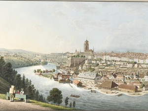
Basel is a real river city. Since the founding of Kleinbasel in the 13th century, it has stretched along both banks of the Rhine, its silhouette reflected in the calmly flowing waters of the wide river. The most important reason for the development of a settlement on the bend of the Rhine was the character of the river: between Neuhausen am Rheinfall and Basel, the High Rhine ran in a fixed riverbed, while below, in the Upper Rhine Plain, it split into many individual branches that were constantly shifting. Until the Rhine corrections in the 19th century, this was the last place where the river could be crossed safely.

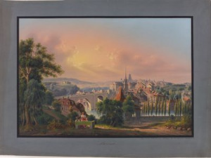
Characteristic of many Kleinmeister views of the city of Basel is the focus on the expansive landscape in which the city is embedded. The cityscape is not the main thing here.

Ort auf moderner Karte
GEOMETRYCOLLECTION (POINT (7.644889 47.557384), LINESTRING (7.644889 47.557384, 7.636464 47.55821))
Camera Settings (3D)
{"landscape":{"image.scale":40,"camera.fov":30,"viewpoint":{"bounds":[[7.5479647853626375,47.53849009349409],[7.645795723723268,47.60532557851673]],"bearing":-83.72993228335542,"pitch":80.52730876800238,"zoom":17.946823456539303,"center":{"lng":7.641567885869904,"lat":47.557570300573985},"cam":{"center":{"lng":7.63488313396806,"lat":47.574767218815225},"zoom":12.379525553861239,"bearing":0},"cameraToCenterDistance":2386.6464914402973,"cameraPosition":{"lngLat":{"lng":7.648079970614106,"lat":47.55708744549631},"altitude":332.52592124293506},"cameraTargetElevation":250.5}},"portrait":{"image.scale":42,"viewpoint":{"bounds":[[7.547964785360961,47.53849009347914],[7.645795723723751,47.60532557851394]],"bearing":-83.72993228335542,"pitch":80.52730876800238,"zoom":17.946823456539303,"center":{"lng":7.641567885870472,"lat":47.55757030057535},"cameraToCenterDistance":2386.6464914402973,"cameraPosition":{"lngLat":{"lng":7.648079970614646,"lat":47.55708744549767},"altitude":332.52592124293295},"cameraTargetElevation":250.5}},"square":{"viewpoint":{"bounds":[[7.54796478536079,47.538490093472035],[7.645795723724319,47.60532557850718]],"bearing":-83.72993228335542,"pitch":80.52730876800238,"zoom":17.946823456539303,"center":{"lng":7.641567885870927,"lat":47.55757030057595},"cam":{"center":{"lng":8.037119477178408,"lat":47.60490961785723},"zoom":8.845418506354376,"bearing":0},"cameraToCenterDistance":2386.6464914402973,"cameraPosition":{"lngLat":{"lng":7.648079970615186,"lat":47.55708744549827},"altitude":332.525921242932},"cameraTargetElevation":250.5}}}
Quellen

Dorothee Huber, Basel, in: Bernd Roeck, Martina Stercken, François Walter, Marco Jorio, Thomas Manetsch (eds.), Schweizer Städtebilder. Urbane Ikonographien (15.-20. Jahrhundert), Zurich 2013, pp. 219-224

Bilder
nb-1000821
Titel
Basel, taken from the Rhine redoubt against the Jura mountains, 1833
Text

"The large city has suburbs all around it, which used to be separated from the city proper by gates, walls and a moat; but the wall has been broken through now and again for some time, and the moat is filled in in some places and laid out into small gardens. The suburbs have streets of varying lengths and widths and are quite beautiful: people prefer to live here than in the city proper, and this is probably the reason why there are so many fine houses in them. Behind some of them are large squares that are laid out as gardens, even vineyards."

Carl Gottlob Küttner's description is not entirely correct - the St. Johanns, Spalen, Steinen, Aeschen and St. Alban suburbs were located within the exceptionally large medieval city wall. This was built at the end of the 14th century after the Basel earthquake, when the older wall, which had actually only enclosed the city center, fell down. In the 17th and 18th centuries, isolated manor houses were built outside this wall.

Ort auf moderner Karte
GEOMETRYCOLLECTION (POINT (7.58298 47.567034), LINESTRING (7.58298 47.567034, 7.584987 47.564531))
Camera Settings (3D)
{"landscape":{"viewpoint":{"bounds":[[7.355330505990082,47.566913032989675],[7.611852868316873,47.770496917502186]],"bearing":147.2393152829436,"pitch":85,"zoom":17.10962121127936,"center":{"lng":7.586613821996025,"lat":47.56325932241566},"cam":{"center":{"lng":7.5995648707092585,"lat":47.67748108376975},"zoom":10.769914942682474,"bearing":0},"cameraToCenterDistance":1918.5,"cameraPosition":{"lngLat":{"lng":7.581471822534638,"lat":47.568651082290074},"altitude":308.87724812648173},"cameraTargetElevation":246.5}},"portrait":{"image.scale":44,"viewpoint":{"bounds":[[7.355330500875539,47.56691303298871],[7.611852869040661,47.77049692206131]],"bearing":147.2393152829436,"pitch":85,"zoom":17.10962121127936,"center":{"lng":7.586613821997048,"lat":47.56325932241373},"cameraToCenterDistance":1918.5,"cameraPosition":{"lngLat":{"lng":7.581471822535661,"lat":47.56865108228814},"altitude":308.877248126484},"cameraTargetElevation":246.5}},"square":{"viewpoint":{"bounds":[[7.355330500819463,47.56691303299385],[7.611852869041769,47.7704969221283]],"bearing":147.2393152829436,"pitch":85,"zoom":17.10962121127936,"center":{"lng":7.586613821990568,"lat":47.56325932241896},"cam":{"center":{"lng":8.637942341930994,"lat":47.75510579925037},"zoom":7.454696559862694,"bearing":0},"cameraToCenterDistance":1918.5,"cameraPosition":{"lngLat":{"lng":7.581471822529181,"lat":47.5686510822934},"altitude":308.8772481264778},"cameraTargetElevation":246.5}}}
Quellen

Carl Gottlob Küttner, Briefe eines Sachsen aus der Schweiz an einen Freund in Leipzig, Leipzig 1785/86, p. 123; Basel, Inventar der schützenswerten Ortsbilder der Schweiz (ISOS) - PDF [24.03.2025]

Bilder
nb-1030793
Titel
Basel from a bird's eye view around 1870
Text

Basel remained enclosed by the medieval city wall until well into the 19th century and the majority of the population continued to live in the Old Town and the suburbs, which were also located within the wall. This meant that living conditions were often precarious, especially in Kleinbasel. There was a typhus epidemic in 1865. From 1860 to the 1880s, the garden and agricultural areas within the city walls, which had remained untouched since the 14th century, were built over with new residential and public buildings.

At the same time, Basel experienced an eventful railroad history: the Railway coming from Alsace reached Basel as early as 1844 and even ended within the city walls. It was the first railroad station on Swiss territory. From 1854, the railroad also ran to Olten. The associated station was located on Aeschenplatz. On the Kleinbasel side, the Grossherzoglich Badische Staatseisenbahnen put the lines to the north and along the High Rhine into operation in 1855/56. A section of the city wall had to be demolished for the Baden station. In 1860, the lines to France and Olten were then connected to the central station - now Basel SBB.

Ort auf moderner Karte
GEOMETRYCOLLECTION (POINT (7.590605 47.54862), LINESTRING (7.590605 47.54862, 7.590627 47.54946))
Camera Settings (3D)
{"landscape":{"image.scale":150,"viewpoint":{"bounds":[[7.424610400591547,47.54572223093649],[7.85630956781597,47.76857824493425]],"bearing":0,"pitch":80.52752167889984,"zoom":16.30903187949166,"center":{"lng":7.590608596801758,"lat":47.553167985950324},"cam":{"center":{"lng":7.767383638315607,"lat":47.66676729433365},"zoom":10.639745230731975,"bearing":0},"cameraToCenterDistance":1918.5,"cameraPosition":{"lngLat":{"lng":7.590608596801758,"lat":47.542106510522984},"altitude":474.4165605105923},"cameraTargetElevation":269.2171875000008}},"portrait":{"image.scale":120,"viewpoint":{"bounds":[[7.42461040061724,47.545722230937145],[7.856309567837712,47.76857824493351]],"bearing":0,"pitch":80.52752167889984,"zoom":16.30903187949166,"center":{"lng":7.5906085968018715,"lat":47.55316798595095},"cameraToCenterDistance":1918.5,"cameraPosition":{"lngLat":{"lng":7.590608596801843,"lat":47.542106510523666},"altitude":474.4165605105899},"cameraTargetElevation":269.2171875000008}},"square":{"image.scale":150,"viewpoint":{"bounds":[[7.424610400729705,47.545722230937514],[7.856309567540308,47.768578244729326]],"bearing":0,"pitch":80.52752167889984,"zoom":16.30903187949166,"center":{"lng":7.590608596803804,"lat":47.553167985951575},"cam":{"center":{"lng":9.583106234782719,"lat":47.802455246472874},"zoom":6.703754882849851,"bearing":0},"cameraToCenterDistance":1918.5,"cameraPosition":{"lngLat":{"lng":7.590608596803719,"lat":47.542106510524206},"altitude":474.4165605105874},"cameraTargetElevation":269.2171875000008}}}
Bilder
nb-476952
Titel
Bern from the north between 1765 and 1770
Text

The Dukes of Zähringen founded Bern in 1191 in a loop of the Aare about 30 meters above the river. In the 18th century, it was considered the cleanest, best-situated city in Switzerland.

"The city's location certainly contributes the most to its health. Not only is it built on a hill, to which one has to climb or drive several hundred shoes when coming from Zurich; but it is also surrounded on three sides by the Aar, which constantly purifies the air and keeps it in moderate motion. Furthermore, none of the larger cities in Switzerland is as close to the highest snow-capped mountains as Bern. This proximity gives it a thinner and purer air than the more distant, and therefore lower-lying cities can enjoy."

The fact that people of all genders who were serving a sentence in the Schallenhaus were used to clean the streets also contributed to the cleanliness of the city.

Ort auf moderner Karte
GEOMETRYCOLLECTION (POINT (7.438551 46.958281), LINESTRING (7.442866 46.951752, 7.438551 46.958281))
Camera Settings (3D)
{"landscape":{"camera.fov":38,"image.scale":40,"viewpoint":{"bounds":[[7.4132888291835,46.8068874030572],[7.607024179173294,46.95886022825158]],"bearing":146.93581511011848,"pitch":80.52708633507116,"zoom":17.308304621696987,"center":{"lng":7.441759407517566,"lat":46.95524772586458},"cam":{"center":{"lng":7.595452769245725,"lat":46.88940493231661},"zoom":11.213151717008804,"bearing":0},"cameraToCenterDistance":1857.2428562736886,"cameraPosition":{"lngLat":{"lng":7.4374295223075535,"lat":46.959787380658184},"altitude":596.3562556526364},"cameraTargetElevation":495.8494873046605}},"portrait":{"image.scale":40,"viewpoint":{"bounds":[[7.412582262705058,46.80338701197712],[7.610578072186456,46.95870717325067]],"bearing":146.93581511011848,"pitch":80.52708633507116,"zoom":17.276921945348853,"center":{"lng":7.441678941249847,"lat":46.95501521454969},"cameraToCenterDistance":1857.2428562736886,"cameraPosition":{"lngLat":{"lng":7.4372538369670735,"lat":46.959654717317505},"altitude":596.3565346540248},"cameraTargetElevation":493.6390624999892}},"square":{"image.scale":40,"viewpoint":{"bounds":[[7.412582262679138,46.803387011974394],[7.610578072202088,46.95870717325039]],"bearing":146.93581511011848,"pitch":80.52708633507116,"zoom":17.276921945348853,"center":{"lng":7.441678941249847,"lat":46.955015214549405},"cam":{"center":{"lng":8.402561310293805,"lat":46.94872713800052},"zoom":7.828311294470035,"bearing":0},"cameraToCenterDistance":1857.2428562736886,"cameraPosition":{"lngLat":{"lng":7.4372538369670735,"lat":46.95965471731728},"altitude":596.3565346540254},"cameraTargetElevation":493.6390624999892}}}
Quellen

Berchtold Friedrich von Haller, Beschreibung der Stadt und Republik Bern, Bern 1794, pp. 4-5

Bilder
nb-859921
Titel
Bern from the new Thun road around 1807
Text

"From whichever side you approach Bern, you will always find something promising, a certain order, layout and cleanliness; wide, carefully maintained country roads; now and again raised side passages for pedestrians; good fountains, simple but attractive buildings, and in the whole area around prosperity and a certain cheerfulness, cheerfulness and cleanliness in the appearance and clothing of the people."

The inmates of the Schallerhaus were not only employed to clean the streets. Between 1779 and 1783, they also built the "Great Muristalden", which can be seen in the foreground of this view. This first section of the road to Thun leads from the Nydeggbrücke bridge to the Kirchenfeld meadow and used to be more direct and steeper. Its edges are designed as an avenue and planted with plane trees.


Ort auf moderner Karte
GEOMETRYCOLLECTION (POINT (7.459846 46.946992), LINESTRING (7.459846 46.946992, 7.457914 46.947182))
Camera Settings (3D)
{"landscape":{"viewpoint":{"bounds":[[7.4598419467304495,46.74666539969897],[7.681916676530733,47.00995925440395]],"bearing":-72.30332226399008,"pitch":81.02786335766078,"zoom":17.004764883844466,"center":{"lng":7.455755174158298,"lat":46.94785263887749},"cam":{"center":{"lng":7.718643336857241,"lat":46.889695296526355},"zoom":10.42041112036406,"bearing":0},"cameraToCenterDistance":1107.646491440297,"cameraPosition":{"lngLat":{"lng":7.461328178530465,"lat":46.9466387012219},"altitude":587.1325459558352},"cameraTargetElevation":517.022753906928}},"portrait":{"viewpoint":{"bounds":[[7.459841946733917,46.74666540210191],[7.681916673925798,47.009959253611896]],"bearing":-72.30332226399008,"pitch":81.02786335766078,"zoom":17.004764883844466,"center":{"lng":7.455755174162277,"lat":46.947852638876896},"cameraToCenterDistance":1107.646491440297,"cameraPosition":{"lngLat":{"lng":7.461328178534416,"lat":46.946638701221275},"altitude":587.132545955836},"cameraTargetElevation":517.022753906928}},"square":{"viewpoint":{"bounds":[[7.459841946732951,46.74666540208369],[7.681916673948791,47.0099592536171]],"bearing":-72.30332226399008,"pitch":81.02786335766078,"zoom":17.004764883844466,"center":{"lng":7.455755174161368,"lat":46.94785263887749},"cam":{"center":{"lng":8.570215582812068,"lat":46.954319520610966},"zoom":7.662735972105204,"bearing":0},"cameraToCenterDistance":1107.646491440297,"cameraPosition":{"lngLat":{"lng":7.461328178533535,"lat":46.9466387012219},"altitude":587.1325459558352},"cameraTargetElevation":517.022753906928},"camera.fov":60}}
Quellen

Berchtold Friedrich von Haller, Beschreibung der Stadt und Republik Bern, Bern 1794, pp. 60-61; Federal Inventory of Historic Transport Routes in Switzerland (IVS), BE 10.2.1 (PDF)[20.01.2025]

Bilder
nb-480767
Titel
Bern from the Thuner Strasse around 1820
Text

It is relatively rare to see the Matte quarter depicted on views of Bern. This quarter, located directly on the banks of the Aare, was home to many businesses that were dependent on water power or consumed large amounts of water, such as saws, stamping mills, mills, grinders and tanneries. The water flow of the three canals running through the quarter could be regulated by means of the Aare sill, which was built in the Middle Ages. The district also had a bad reputation due to the many bathhouses located here. Before traffic switched to rail from the 1850s onwards, the Matte was also the mooring point for ships traveling between Thun and Bern.


Ort auf moderner Karte
GEOMETRYCOLLECTION (POINT (7.45983 46.946816), LINESTRING (7.45983 46.946816, 7.457018 46.94686))
Camera Settings (3D)
{"landscape":{"camera.fov":47,"image.scale":32,"viewpoint":{"bounds":[[7.150263382356911,46.81475540191164],[7.459501539748743,47.16597906577718]],"bearing":-89.1020660113424,"pitch":80.5272863136957,"zoom":17.406544357986196,"center":{"lng":7.455175817012787,"lat":46.946852878005785},"cam":{"center":{"lng":7.502407196086608,"lat":47.00562421071686},"zoom":10.0016728665791,"bearing":0},"cameraToCenterDistance":1470.7493089575862,"cameraPosition":{"lngLat":{"lng":7.461046155425066,"lat":46.946790067012785},"altitude":577.788585062017},"cameraTargetElevation":503.4265625000465}},"portrait":{"image.scale":27,"viewpoint":{"bounds":[[7.150263379645338,46.814755400652274],[7.459501539749482,47.165979067762436]],"bearing":-89.1020660113424,"pitch":80.5272863136957,"zoom":17.406544357986196,"center":{"lng":7.4551758170129006,"lat":46.946852878005586},"cameraToCenterDistance":1470.7493089575862,"cameraPosition":{"lngLat":{"lng":7.461046155425265,"lat":46.94679006701256},"altitude":577.7885850620173},"cameraTargetElevation":503.4265625000465}},"square":{"image.scale":30,"viewpoint":{"bounds":[[7.150263379635305,46.814755400693514],[7.459501539749681,47.16597906774413]],"bearing":-89.1020660113424,"pitch":80.5272863136957,"zoom":17.406544357986196,"center":{"lng":7.455175817013242,"lat":46.9468528780055},"cam":{"center":{"lng":8.69645418020707,"lat":47.09602008702598},"zoom":7.185062831815894,"bearing":0},"cameraToCenterDistance":1470.7493089575862,"cameraPosition":{"lngLat":{"lng":7.461046155425606,"lat":46.9467900670125},"altitude":577.7885850620174},"cameraTargetElevation":503.4265625000465}}}
Quellen

Paul Hofer, Die Kunstdenkmäler des Kantons Bern, Band II: Die Stadt Bern, Gesellschaftshäuser und Wohnbauten, Basel 1959, pp. 460-461

Bilder
nb-1000061
Titel
Bern, taken from the lower gate towards the Gurten, 1832
Text

The important entrance to the city from the east was via Untertorbrücke. For a long time, it was the only bridge over the Aare in Bern and was therefore of great importance for the city's fortifications. The stone bridge, which was built between 1461 and 1489, was equipped with two fortifications at both ends. At the eastern end was the bridge tower, which dates back to at least 1335 and is still standing today. There was also a chapel on the western of the two bridge piers.

The bridge was rebuilt several times. In the 16th century, it was given high, crenellated parapets and the bridge tower was also reinforced. Later, the side of the bridge facing downstream was even given a wall with a wooden walkway. The 18th century then saw a radical redesign of the eastern end of the town. In 1757-59, the bridge was completely renovated and most of the fortifications, including the chapel, were removed. Both ends of the bridge were given ornate gateways, which were no longer used for defense but for representation. The crenellated walls were replaced by sandstone parapets.

In 1818-21, the situation as depicted in the view finally emerged. The stone parapets were replaced by wrought iron railings, the gate towards the city was demolished and the moat at the eastern bridgehead was filled in.

Ort auf moderner Karte
GEOMETRYCOLLECTION (POINT (7.458928 46.949683), LINESTRING (7.458928 46.949683, 7.457764 46.949353))
Camera Settings (3D)
{"landscape":{"viewpoint":{"bounds":[[7.351396756688189,46.930987290499274],[7.460370693090653,47.017920213597336]],"bearing":-77.23856456129027,"pitch":79.74211210713409,"zoom":17.82447196301134,"center":{"lng":7.456331849102526,"lat":46.949925343686516},"cam":{"center":{"lng":7.454759158620561,"lat":46.978176720709655},"zoom":12.016524782283359,"bearing":0},"cameraToCenterDistance":1918.5,"cameraPosition":{"lngLat":{"lng":7.461909268672315,"lat":46.94906302153046},"altitude":580.8361553237693},"cameraTargetElevation":502.27968749985905}},"portrait":{"viewpoint":{"bounds":[[7.350540575670948,46.930876388662085],[7.460437071944057,47.0185448536557]],"bearing":-77.23856456129027,"pitch":79.74211210713409,"zoom":17.812309696215497,"center":{"lng":7.456364035606384,"lat":46.949974780012525},"cameraToCenterDistance":1918.5,"cameraPosition":{"lngLat":{"lng":7.46198867291568,"lat":46.949105158288404},"altitude":580.8360923632642},"cameraTargetElevation":501.61464843705045}},"square":{"viewpoint":{"bounds":[[7.3513764861426125,46.93098387933415],[7.460370794468361,47.017932975394814]],"bearing":-77.23856456094404,"pitch":79.74330810679992,"zoom":17.824477412637243,"center":{"lng":7.456331849106391,"lat":46.94992534368592},"cam":{"center":{"lng":7.896348027771381,"lat":47.01164789250785},"zoom":8.689528391669933,"bearing":0},"cameraToCenterDistance":1918.5,"cameraPosition":{"lngLat":{"lng":7.46190926867618,"lat":46.94906302152984},"altitude":580.1617584619777},"cameraTargetElevation":501.61464843705045}}}
Quellen

Paul Hofer, Die Kunstdenkmäler des Kantons Bern, Band I: Die Stadt Bern, Basel 1952, pp. 194-209

Bilder
nb-477335
Titel
Bern from the east between 1844 and 1850
Text

As early as 1827, the entrepreneur Karl Anton von Lerber (1784-1837) and the engineer Albrecht Sinner (1797-1858) felt that the Untertorbrücke, with its low height and steep inclines, was no longer suitable for the increasing traffic. In 1836, they founded a joint-stock company with the aim of building a new, higher bridge. The 900 shares subscribed at CHF 1,000 each testify to the great interest in the construction. Today, this corresponds to a sum of around 110,000,000 Swiss francs. Construction work on the new Nydegg Bridge began in 1840, following disputes over the choice of location, and lasted until 1844. In addition to the bridge itself, an approach road from the lower town also had to be built, and a number of old town houses fell victim to this. In addition, the bridge also had four toll and guard houses, as the company hoped to generate a lot of revenue from the bridge toll. However, these hopes were dashed with the introduction of the new federal constitution on March 1, 1853, which abolished all existing customs duties on Swiss soil.

The Nydegg Bridge is an impressive structure. With a span of 46 meters, the main arch was the largest bridge arch in Europe for around 50 years, the length of the bridge is 190 meters in total and the roadway is a good 25 meters above the Aare. Unlike most other structures in Bern, the Nydegg Bridge was mainly clad in granite obtained from erratic boulders in the Bernese Oberland.


Ort auf moderner Karte
GEOMETRYCOLLECTION (POINT (7.45963 46.949602), LINESTRING (7.45963 46.949602, 7.458906 46.949163))
Camera Settings (3D)
{"landscape":{"viewpoint":{"bounds":[[7.390659509552421,46.91689460993169],[7.460845557104676,46.9639686680697]],"bearing":-112.0231776984337,"pitch":76.52715986410524,"zoom":18.162204236667343,"center":{"lng":7.45797872543335,"lat":46.94885146557016},"cam":{"center":{"lng":7.452201685145752,"lat":46.94244326136538},"zoom":12.902412829430407,"bearing":0},"cameraToCenterDistance":1918.5,"cameraPosition":{"lngLat":{"lng":7.462124463007342,"lat":46.94999621658488},"altitude":589.4851773960497},"cameraTargetElevation":508.1577148437507}},"portrait":{"viewpoint":{"bounds":[[7.3914293856903726,46.91757405672763],[7.460650578354972,46.9640006745536]],"bearing":-112.0231776984337,"pitch":76.52715986410524,"zoom":18.182174697224404,"center":{"lng":7.457823157310486,"lat":46.94909132768325},"cameraToCenterDistance":1918.5,"cameraPosition":{"lngLat":{"lng":7.461911903007149,"lat":46.95022033679538},"altitude":589.4848430197665},"cameraTargetElevation":509.2757568359382}},"square":{"viewpoint":{"bounds":[[7.39142938581827,46.91757405679232],[7.460650578357644,46.964000674530894]],"bearing":-112.0231776984337,"pitch":76.52715986410524,"zoom":18.182174697224404,"center":{"lng":7.457823157312987,"lat":46.94909132768251},"cam":{"center":{"lng":7.737535348515166,"lat":46.96441769774273},"zoom":9.34449548970613,"bearing":0},"cameraToCenterDistance":1918.5,"cameraPosition":{"lngLat":{"lng":7.461911903009707,"lat":46.950220336794644},"altitude":589.4848430197676},"cameraTargetElevation":509.2757568359382}}}
Quellen

Paul Hofer, Die Kunstdenkmäler des Kantons Bern, Band I: Die Stadt Bern, Basel 1952, pp. 213-220

Bilder
nb-865285
Titel
Bern from the Christoffel Tower around 1859
Text

In the second half of the century, a new era also clearly began in Bern. In 1848, it had become a federal city and now had to provide the infrastructure of a political capital. The so-called "Bundesratshaus" and the luxury Bernerhof hotel, which housed the parliamentarians during the sessions, can be seen on the right. The railroad station in the foreground opened in 1858 and connected Bern with Olten; the line to Thun was to be completed the following year. The area surrounding the old town is still largely undeveloped. This fictitious bird's eye view highlights the modern focus of the city in the west, while the long lower town, including the cathedral and the Zytglogge, seems to be lost in the shadows of history.

Ort auf moderner Karte
GEOMETRYCOLLECTION (POINT (7.438087 46.948481), LINESTRING (7.438087 46.948481, 7.439847 46.948275))
Camera Settings (3D)
{"landscape":{"viewpoint":{"bounds":[[7.4362436266717395,46.8576155922143],[7.589545156629924,46.98633322612267]],"bearing":96.78640259728161,"pitch":80.52725497543526,"zoom":17.494565263847804,"center":{"lng":7.441298067569619,"lat":46.94821884697893},"cam":{"center":{"lng":7.585191137678748,"lat":46.92749924978813},"zoom":11.451703572528253,"bearing":0},"cameraToCenterDistance":1918.5,"cameraPosition":{"lngLat":{"lng":7.434143406057814,"lat":46.94880007318065},"altitude":644.0627974840055},"cameraTargetElevation":552.8054687501799}},"portrait":{"viewpoint":{"bounds":[[7.436243626672081,46.857615592213904],[7.589545156588827,46.98633322612227]],"bearing":96.78640259728161,"pitch":80.52725497543526,"zoom":17.494565263847804,"center":{"lng":7.441298067570642,"lat":46.94821884697862},"cameraToCenterDistance":1918.5,"cameraPosition":{"lngLat":{"lng":7.4341434060588085,"lat":46.94880007318031},"altitude":644.0627974840061},"cameraTargetElevation":552.8054687501799}},"square":{"viewpoint":{"bounds":[[7.436243626671342,46.857615592225386],[7.5895451566128145,46.98633322613375]],"bearing":96.78640259728161,"pitch":80.52725497543526,"zoom":17.494565263847804,"center":{"lng":7.441298067569505,"lat":46.94821884697828},"cam":{"center":{"lng":8.202751276378677,"lat":46.974339439221126},"zoom":8.19740909612537,"bearing":0},"cameraToCenterDistance":1918.5,"cameraPosition":{"lngLat":{"lng":7.4341434060577,"lat":46.948800073180024},"altitude":644.0627974840066},"cameraTargetElevation":552.8054687501799}}}
Quellen

Bernhard Furrer, Bern, in: Bernd Roeck, Martina Stercken, François Walter, Marco Jorio, Thomas Manetsch (eds.), Schweizer Städtebilder. Urbane Ikonographien (15.-20. Jahrhundert), Zurich 2013, pp. 231-238; Anne-Marie Dubler; Hans Grütter; Urs Martin Zahnd; Beat Junker; Bruno Fritzsche; Alfred Kuert: "Bern (municipality)", in: Historical Dictionary of Switzerland (HLS), version of 10.11.2016. [28.11.2024]

Bilder
nb-881756
Titel
Fribourg with the Pont Suspendu, 1834
Text

Freiburg im Üechtland was founded in 1157 by the Dukes of Zähringen. Its location probably goes back to an old ford over the Saane on the route from Burgdorf to Lausanne. Political considerations also played a role. Above all, however, the rocky rib in the course of the Saane was easy to fortify. In the 14th and 15th centuries, Fribourg experienced a period of prosperity due to wool and leather production. The town spread out along both banks of the river and fortified itself with an impressive town wall, large parts of which are still preserved today. The Saxon pilgrim Hans von Waltheim (1422-1479) described the city in 1475 as being so well fortified that even the Pope and the Emperor together could not take it if they tried:

"The city of Fryborgk is the most ingenious and fortified city I have ever seen, and if the Pope and the Emperor were their enemies, they would have a hard time taking it etc. [...] The town of Ffryborg is a merry town, and is half German and half French."

However, the safe location also had its disadvantages: There were steep inclines to overcome on both sides of the Saane if you wanted to reach the town from the east. Planning for a large bridge began in 1824, which was finally built in 1832-34.


Ort auf moderner Karte
GEOMETRYCOLLECTION (POINT (7.165596 46.807343), LINESTRING (7.165596 46.807343, 7.166605 46.806504))
Camera Settings (3D)
{"landscape":{"viewpoint":{"bounds":[[7.083202668227443,46.80780250172489],[7.1646037509624705,46.87305821203168]],"bearing":131.99740895929835,"pitch":85,"zoom":18.761337629735685,"center":{"lng":7.1661584079247405,"lat":46.80697649525669},"cam":{"center":{"lng":7.1604996567941726,"lat":46.84322165373467},"zoom":12.433930689771847,"bearing":0},"cameraToCenterDistance":1918.5,"cameraPosition":{"lngLat":{"lng":7.1639108839917185,"lat":46.8083614758703},"altitude":560.7933792812383},"cameraTargetElevation":540.6562499998606}},"portrait":{"image.scale":41,"viewpoint":{"bounds":[[7.083202666481441,46.807802501725774],[7.164603750960282,46.87305821343969]],"bearing":131.99740895929835,"pitch":85,"zoom":18.761337629735685,"center":{"lng":7.166158407923831,"lat":46.80697649525655},"cameraToCenterDistance":1918.5,"cameraPosition":{"lngLat":{"lng":7.163910883990923,"lat":46.80836147587016},"altitude":560.7933792812383},"cameraTargetElevation":540.6562499998606}},"square":{"image.scale":39,"viewpoint":{"bounds":[[7.083202668300942,46.80780250172913],[7.164603750953404,46.873058211977025]],"bearing":131.99740895929835,"pitch":85,"zoom":18.761337629735685,"center":{"lng":7.166158407916441,"lat":46.806976495260386},"cam":{"center":{"lng":7.490208081563196,"lat":46.86827354066094},"zoom":9.110661303321173,"bearing":0},"cameraToCenterDistance":1918.5,"cameraPosition":{"lngLat":{"lng":7.163910883983391,"lat":46.80836147587405},"altitude":560.7933792812369},"cameraTargetElevation":540.6562499998606}}}
Quellen

François Guex, Freiburgs Brücken und Strassen im 13. Jahrhundert, in: Freiburger Geschichtsblätter, vol. 82 (2005), pp. 7-18; Friedrich Emil Welti (ed.), Die Pilgerfahrt des Hans von Waltheym im Jahre 1474, Bern 1925, p. 13; Louis-Joseph Schmid, Description historique et technique du grand-pont, suspendu en fil de fer, à Fribourg en Suisse, Fribourg 1839

Bilder
nb-879160
Titel
Fribourg, Pont Suspendu with the Church of St. Nicholas, 1834
Text

It was the longest iron suspension bridge in the world at the time. It was 273 m long and was 51 m above the valley floor. The bridge, known simply as the "Grand Pont", was so dilapidated in 1924 that it had to make way for a concrete arch bridge, today's Zähringer Bridge.

The final accounts from 1840 show that the bridge construction cost 273,619 Swiss francs [today approx. 33,600,000 Swiss francs], the same amount as the subscription process had brought in. Of this, CHF 25,700,000 went to the engineer Joseph Chaley as a fee, while the remaining CHF 7,900,000 was used for other expenses associated with the construction project, such as compensation for local residents. Chaley also secured the right to the bridge tolls incurred during the first 40 years.

Ort auf moderner Karte
GEOMETRYCOLLECTION (POINT (7.168396 46.807262), LINESTRING (7.168396 46.807262, 7.167323 46.807056))
Camera Settings (3D)
{"landscape":{"viewpoint":{"bounds":[[7.097329097940559,46.777390077682924],[7.168887791194749,46.83226113825762]],"bearing":-101.43014199557086,"pitch":74.36959325589348,"zoom":17.855918699348077,"center":{"lng":7.165550887588552,"lat":46.80655699953434},"cam":{"center":{"lng":7.163860639342147,"lat":46.807171379297955},"zoom":12.684944908727052,"bearing":0},"cameraToCenterDistance":1918.5,"cameraPosition":{"lngLat":{"lng":7.170918269457275,"lat":46.80729976945733},"altitude":651.2455568072311},"cameraTargetElevation":534.6423095293289}},"portrait":{"image.scale":45,"viewpoint":{"bounds":[[7.095556331674089,46.776970784391466],[7.168760683149458,46.83310351129444]],"bearing":-101.43014199557086,"pitch":74.36959325589348,"zoom":17.82311633257389,"center":{"lng":7.165347039699554,"lat":46.80680851377275},"cameraToCenterDistance":1918.5,"cameraPosition":{"lngLat":{"lng":7.170837856971332,"lat":46.80756836174032},"altitude":651.2449940153024},"cameraTargetElevation":531.9607421873839}},"square":{"viewpoint":{"bounds":[[7.097284972783427,46.77758382011095],[7.168850646883726,46.83245994263174]],"bearing":-101.43014199638343,"pitch":74.3684467339845,"zoom":17.855706966530285,"center":{"lng":7.165513336658478,"lat":46.806753437762694},"cam":{"center":{"lng":7.4551133432850065,"lat":46.829516051094004},"zoom":9.296441509784088,"bearing":0},"cameraToCenterDistance":1918.5,"cameraPosition":{"lngLat":{"lng":7.170881476257904,"lat":46.80749630983132},"altitude":648.5725637106896},"cameraTargetElevation":531.9442871093746}}}
Quellen

Louis-Joseph Schmid, Description historique et technique du grand-pont, suspendu en fil de fer, à Fribourg en Suisse, Fribourg 1839, p. 11 and leaflet at the back

Bilder
nb-881825
Titel
Fribourg from a bird's eye view from the east, 1862
Text

"The road from Murten to Fribourg offers some pleasant viewpoints, but the sight of Fribourg itself is extraordinary and I find it difficult to give you a satisfactory idea of it. Imagine a deep abyss with a torrent flowing in its depths. Fribourg was built on the banks of this torrent, called the Saane, and on the sandstone cliffs that surround it on all sides. On a site so steeply sloping that instead of a road, a steep staircase with ramps on both sides leads upwards, the houses have no roof other than the terrace that supports the neighboring road. On a hill, hovering over the abyss mentioned, and overlooking the whole town, one sees with palpitation extremely high houses, built on the edge of the rock itself, so that they seem to be only a continuation of it; And these houses, as is generally the case in Switzerland, are mostly adorned on the outside with wooden galleries, which open towards the abyss, and from which the steadfast must turn their heads when their gaze falls into the depths of this abyss. For the rest, Fribourg is a desolate city, built in a ponderous and Gothic style."


Ort auf moderner Karte
GEOMETRYCOLLECTION (POINT (7.173149 46.802993), LINESTRING (7.173149 46.802993, 7.168815 46.804198))
Camera Settings (3D)
{"landscape":{"viewpoint":{"bounds":[[7.046790342084051,46.80159806817039],[7.174963263066161,46.894880618027486]],"bearing":-60.92737146911326,"pitch":74.04638126571409,"zoom":16.984545385226262,"center":{"lng":7.1680748462677,"lat":46.804965272667175},"cam":{"center":{"lng":7.163198764895213,"lat":46.852235524835066},"zoom":11.918217637832793,"bearing":0},"cameraToCenterDistance":1918.5,"cameraPosition":{"lngLat":{"lng":7.176816481071199,"lat":46.801638534670104},"altitude":749.4012554738451},"cameraTargetElevation":531.7828125000408}},"portrait":{"viewpoint":{"bounds":[[7.0467903420718585,46.801598068171074],[7.174963263067298,46.894880618035444]],"bearing":-60.92737146911326,"pitch":74.04638126571409,"zoom":16.984545385226262,"center":{"lng":7.1680748462694055,"lat":46.804965272667545},"cameraToCenterDistance":1918.5,"cameraPosition":{"lngLat":{"lng":7.176816481072848,"lat":46.801638534670474},"altitude":749.4012554738435},"cameraTargetElevation":531.7828125000408}},"square":{"viewpoint":{"bounds":[[7.0467903420682205,46.80159806817173],[7.174963263067156,46.894880618038485]],"bearing":-60.92737146911326,"pitch":74.04638126571409,"zoom":16.984545385226262,"center":{"lng":7.168074846269974,"lat":46.80496527266857},"cam":{"center":{"lng":7.687654947062811,"lat":46.89207254684996},"zoom":8.455689694214355,"bearing":0},"cameraToCenterDistance":1918.5,"cameraPosition":{"lngLat":{"lng":7.176816481073331,"lat":46.80163853467147},"altitude":749.4012554738395},"cameraTargetElevation":531.7828125000408}}}
Quellen

Desirée Raoul Rochette, Lettres sur quelques cantons de la Suisse, écrites en 1819, Paris 1820, pp. 42-43

Bilder
zbz-990102391290205508
Titel
Geneva from Cornavin around 1800
Text

"The situation of Geneva is in many respects as happy as the heart of man could desire, or his imagination conceive. The Rhone, rushing out of the noblest lake in Europe, flows through the middle of the city, which is encircled by fertile fields, cultivated by the industry, and adorned by the riches and taste of the inhabitants."

Around 1800, Geneva was by far the largest city in the territory of today's Swiss Confederation with 25,000 inhabitants. Even though Geneva became a Swiss canton only in 1803, it was generally considered part of the Confederation due to its 16th century alliances with Bern, Solothurn and Zurich. This view from the end of the 18th century shows Geneva from the north, roughly where Cornavin railroad station stands today. In the foreground is the St-Gervais quarter with the Porte de Suisse, so named because this is where the traffic routes from Switzerland enter the city.


Ort auf moderner Karte
GEOMETRYCOLLECTION (POINT (6.141513 46.211387), LINESTRING (6.141513 46.211387, 6.142709 46.208191))
Camera Settings (3D)
{"landscape":{"viewpoint":{"bounds":[[6.096181897827535,46.10665205648601],[6.23021876164006,46.211710526654315]],"bearing":163.8029740252707,"pitch":82.99619701948791,"zoom":18.23009730243027,"center":{"lng":6.142674386503018,"lat":46.20910807064149},"cam":{"center":{"lng":6.221385191588013,"lat":46.16368419966622},"zoom":11.76499043627968,"bearing":0},"cameraToCenterDistance":2386.6464914402973,"cameraPosition":{"lngLat":{"lng":6.141163351752681,"lat":46.21270790087357},"altitude":438.2648934753622},"cameraTargetElevation":387.05507812498564},"image.scale":50},"portrait":{"image.scale":46,"viewpoint":{"bounds":[[6.101736166670634,46.121457779155094],[6.217857933153994,46.21246148831099]],"bearing":163.8029740252707,"pitch":82.99619701948791,"zoom":18.437088696076895,"center":{"lng":6.142014563083649,"lat":46.21020690926531},"cameraToCenterDistance":2386.6464914402973,"cameraPosition":{"lngLat":{"lng":6.140705490178931,"lat":46.21332554474381},"altitude":438.2643275555258},"cameraTargetElevation":393.89999999999964}},"square":{"viewpoint":{"bounds":[[6.089703752537957,46.092169998120596],[6.2423794850455465,46.211851832788824]],"bearing":163.80297402523004,"pitch":82.99230732970639,"zoom":18.04009763707608,"center":{"lng":6.142663657665253,"lat":46.20888347422877},"cam":{"center":{"lng":6.8530824150759315,"lat":46.2049008729158},"zoom":8.203310424257355,"bearing":0},"cameraToCenterDistance":2386.6464914402973,"cameraPosition":{"lngLat":{"lng":6.140939938828666,"lat":46.21298999257942},"altitude":445.13830646915756},"cameraTargetElevation":386.6874999999475}}}
Quellen

John Moore, A view of society and manners in France, Switzerland and Germany With anecdotes relating to some eminent characters, vol. 1, Dublin 1780, p. 107; Johann Gottfried Ebel, Anleitung, auf die nützlichste und genussvollste Art die Schweiz zu bereisen, vol. 2, Zurich 1810, p. 35

Bilder
nb-479854
Titel
Geneva from Cologny, 1811
Text

Geneva suffered economic and social damage as a result of the political unrest at the end of the 18th century and the subsequent French Revolution. The population fell from 26,140 to 22,055 between 1789 and 1806. Johann Gottfried Ebel (1764-1830) wrote in 1810:

"This free state established an eternal alliance with Bern in 1558 and with Zurich and Solothurn in 1584, joined the Swiss Confederation and has always been regarded as part of Switzerland, in which Geneva was the largest city. Since the beginning of the fifteenth century, Geneva had been characterized by its bustle and commercial spirit; but since the Reformation, the sciences, arts and industriousness have flourished there to an admirable degree. No civil community in Europe has produced so many famous scholars and writers in proportion to its population, enjoyed such widespread intellectual development and such great wealth. In the course of the XVIII. In the course of the XVIIIth century, very violent internal disturbances repeatedly broke out in the city of Geneva, leading on several occasions to open hostilities [...]. The splendor of this small but all the more remarkable free state was suddenly dimmed. The political convulsions of France were communicated to it in 1793; terrible atrocities and anarchy dwelt within it for several years. [...] Europe lost one of the most remarkable parts of the diverse life of the European peoples through the destruction of this free state. Geneva until 1792. is no longer recognizable in any respect in the Geneva of 1800. In those happy times, Geneva had the inner and outer vitality and splendor that only the capital of a great country can have, combined with the niceness and cleanliness of a free Swiss city."

Ort auf moderner Karte
GEOMETRYCOLLECTION (POINT (6.180473 46.21553), LINESTRING (6.180473 46.21553, 6.177229 46.214146))
Camera Settings (3D)
{"landscape":{"viewpoint":{"bounds":[[6.179132415915774,46.19257691168028],[6.732591479531493,46.50798088633431]],"bearing":-124.84379078259907,"pitch":85,"zoom":16.24156304894114,"center":{"lng":6.169617176055567,"lat":46.210308996206095},"cam":{"center":{"lng":6.6311535166508975,"lat":46.36394854522885},"zoom":10.173949584806595,"bearing":0},"cameraToCenterDistance":1918.5,"cameraPosition":{"lngLat":{"lng":6.183851344787968,"lat":46.21716583020256},"altitude":495.94713011387955},"cameraTargetElevation":379.1874998875549}},"portrait":{"viewpoint":{"bounds":[[6.179132415915348,46.19257691174823],[6.732591478653148,46.50798088589531]],"bearing":-124.84379078259907,"pitch":85,"zoom":16.24156304894114,"center":{"lng":6.169617176054771,"lat":46.21030899620658},"cameraToCenterDistance":1918.5,"cameraPosition":{"lngLat":{"lng":6.183851344787257,"lat":46.217165830203015},"altitude":495.94713011387853},"cameraTargetElevation":379.1874998875549}},"square":{"viewpoint":{"bounds":[[6.179132415913699,46.192576911726434],[6.732591478772491,46.5079808859291]],"bearing":-124.84379078259907,"pitch":85,"zoom":16.24156304894114,"center":{"lng":6.1696171760536345,"lat":46.21030899620587},"cam":{"center":{"lng":8.946427730207745,"lat":46.541183809304584},"zoom":6.3453045806144335,"bearing":0},"cameraToCenterDistance":1918.5,"cameraPosition":{"lngLat":{"lng":6.183851344786177,"lat":46.217165830202305},"altitude":495.94713011388006},"cameraTargetElevation":379.1874998875549}}}
Quellen

Geneva, Inventory of Swiss Sites Worthy of Protection (ISOS) - PDF, p. 9; Johann Gottfried Ebel, Anleitung, auf die nützlichste und genussvollste Art die Schweitz bereisen, vol. 3, Zurich 1810, pp. 35-36

Bilder
nb-879610
Titel
Geneva from Lake Geneva around 1820
Text

Alexandre Dumas visited Geneva in 1833 and wrote: 
"After Naples, Geneva is one of the most happily situated cities in the world. As lazily as she lies, leaning her head against the foot of Mont Salève and stretching her feet, kissed by every tide, to the lake, she seems to have nothing to do but gaze with love at the thousand villas sown on the flanks of the snow-capped mountains that stretch to her right, or crowning the summits of the green hills that continue to her left. At a wave of her hand she sees from the misty background of the lake the light boats with their triangular sails hurrying along, gliding white and swift as gulls over the surface of the water, and the heavy steamers chasing the foam with their bosoms. Under this beautiful sky, in front of these beautiful waters, it seems as if her arms are useless and as if she only has to breathe to live; and yet this nonchalant odalisque, this seemingly lazy sultana is the queen of industry, the Geneva merchant woman who counts eighty-five millionaires among her twenty thousand children."

The Basel artist Konrad Witz (c. 1400-1445/7) had already painted roughly the same view with Les Voirons, Le Môle and the Petit Salève in 1444. His altarpiece painted for Geneva Cathedral is the earliest topographically identifiable landscape depiction in European art - and in this respect the predecessor of all Kleinmeister views.

Ort auf moderner Karte
GEOMETRYCOLLECTION (POINT (6.152687 46.211294), LINESTRING (6.152687 46.211294, 6.156678 46.205503))
Camera Settings (3D)
{"landscape":{"camera.fov":60,"viewpoint":{"bounds":[[6.109151086987907,46.2117399011303],[6.183331883464888,46.24925209334202]],"bearing":156.50848992778697,"pitch":85,"zoom":16.876298004901816,"center":{"lng":6.154639720916748,"lat":46.20852337558668},"cam":{"center":{"lng":6.162161060029206,"lat":46.23172280023664},"zoom":13.634832484207054,"bearing":0},"cameraToCenterDistance":1107.646491440297,"cameraPosition":{"lngLat":{"lng":6.1520689837406906,"lat":46.21261639840935},"altitude":411.41821262324356},"cameraTargetElevation":368}},"portrait":{"viewpoint":{"bounds":[[6.109151087173814,46.21173990113229],[6.18333188340435,46.24925209327668]],"bearing":156.50848992778697,"pitch":85,"zoom":16.876298004901816,"center":{"lng":6.15463972091527,"lat":46.20852337558887},"cameraToCenterDistance":1107.646491440297,"cameraPosition":{"lngLat":{"lng":6.152068983739127,"lat":46.21261639841157},"altitude":411.4182126232418},"cameraTargetElevation":368}},"square":{"viewpoint":{"bounds":[[6.109151086958235,46.21173990113098],[6.183331883551034,46.24925209345142]],"bearing":156.50848992778697,"pitch":85,"zoom":16.876298004901816,"center":{"lng":6.154639720915384,"lat":46.20852337558742},"cam":{"center":{"lng":6.480055069922145,"lat":46.256150817208464},"zoom":9.244663525754955,"bearing":0},"cameraToCenterDistance":1107.646491440297,"cameraPosition":{"lngLat":{"lng":6.152068983739298,"lat":46.21261639841012},"altitude":411.418212623243},"cameraTargetElevation":368}}}
Quellen

Les Bourlapapey, bibliothèque numérique romande (ed.), Alexandre Dumas, Impressions de voyage en Suisse. Du Mont Blanc à Berne, vol. 1 (1833/34), p. 47

Bilder
nb-873119
Titel
Geneva from the promenade near the Hotel de Bergues between 1844 and 1851
Text

"Seen from the lake and from the water, Geneva presents itself from its most beautiful side. Two beautiful, completely new quays with magnificent houses have replaced the dreadful huts between which the Rhône flowed just 15 years ago. However, it must be admitted that the interior of the city does not yet match the exterior."

With the growth in tourism, several hotels were built on the new quays to welcome guests from all over Europe. The Hôtel des Bergues opened in 1834, followed by the Hôtels de la Couronne and de l'Écu. On the right bank, the new district was built on the Quai des Bergues, where an India nectar factory once stood. In 1826, James Fazy and Guillaume-Henri Dufour founded the Société anonyme des Bergues, which beautified the town and helped to relieve the Pont de l'Île bridge. The Pont des Bergues was built in 1834 and a pedestrian bridge was added in 1841.


Ort auf moderner Karte
GEOMETRYCOLLECTION (POINT (6.147612 46.206883), LINESTRING (6.147612 46.206883, 6.146953 46.206583))
Camera Settings (3D)
{"landscape":{"viewpoint":{"bounds":[[6.056134024976416,46.157345697832966],[6.1489554738572565,46.20949227755793]],"bearing":-126.83399983387986,"pitch":80.52714585967189,"zoom":18.506624061047738,"center":{"lng":6.146656125781874,"lat":46.20633581841659},"cam":{"center":{"lng":6.131437973533082,"lat":46.18564782330492},"zoom":12.774903088247692,"bearing":0},"cameraToCenterDistance":1918.5,"cameraPosition":{"lngLat":{"lng":6.149515535491361,"lat":46.20781803158155},"altitude":414.00298681306253},"cameraTargetElevation":368.1302490233091}},"portrait":{"viewpoint":{"bounds":[[6.056134025071401,46.15734569786045],[6.1489554738579955,46.209492277538004]],"bearing":-126.83399983387986,"pitch":80.52714585967189,"zoom":18.506624061047738,"center":{"lng":6.146656125782442,"lat":46.20633581841744},"cameraToCenterDistance":1918.5,"cameraPosition":{"lngLat":{"lng":6.149515535492014,"lat":46.207818031582406},"altitude":414.0029868130618},"cameraTargetElevation":368.1302490233091},"image.scale":38},"square":{"viewpoint":{"bounds":[[6.05613402546544,46.15734569804155],[6.148955473858933,46.20949227750356]],"bearing":-126.83399983387986,"pitch":80.52714585967189,"zoom":18.506624061047738,"center":{"lng":6.146656125783579,"lat":46.20633581841736},"cam":{"center":{"lng":6.520241267433022,"lat":46.21554833523797},"zoom":8.921251076488566,"bearing":0},"cameraToCenterDistance":1918.5,"cameraPosition":{"lngLat":{"lng":6.1495155354930375,"lat":46.20781803158226},"altitude":414.00298681306185},"cameraTargetElevation":368.1302490233091}}}
Quellen

Adolphe Joanne, Itinéraire descriptif et historique de la Suisse, Paris 1841, p. 140; Geneva, Inventar der schützenswerten Ortsbilder der Schweiz (ISOS) - PDF [10.02.2025]

Bilder
nb-880392
Titel
Geneva around 1860
Text

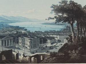
With the demolition of the fortifications from the 16th - 18th centuries, huge, flat areas became available to be overbuilt in Geneva from the 1850s. Residential, commercial, administrative and cultural buildings shot up around the old town and the St. Gervais district on the right bank of the Rhone. This was done according to a uniform plan, which in part contradicted the historically grown structures of the old suburban communities. This ring development is also known as the "Ceinture Fazyste", or Fazy Belt, after its initiator, the radical politician and long-time mayor James Fazy (1794-1878). This expansion was also urgently needed, as the population of the city center grew from 31,238 inhabitants in 1850 to 52,034 in 1888.

This view from around 1860 shows some buildings in the foreground that are reminiscent of this development. However, the entire topography, especially the hill from which the view was taken, is pure fantasy. The ruins at the lower edge of the picture are perhaps reminiscent of this time, when Geneva was on the move and had added a new face - it is no coincidence that James Fazy is also known as the creator of modern Geneva. But perhaps the slightly eerie scenery also refers to the great tensions that Geneva faced in the 19th century. Politics in those years was characterized by a contrast between conservatism and radicalism. When James Fazy was not re-elected as mayor in 1864, riots broke out to such an extent that even the Swiss army had to intervene.


Ort auf moderner Karte
GEOMETRYCOLLECTION (POINT (6.141433 46.201779), LINESTRING (6.141433 46.201779, 6.14184 46.20192))
Camera Settings (3D)
{"landscape":{"viewpoint":{"bounds":[[6.13978368511664,46.18469102678941],[6.293545556501755,46.27940341165092]],"bearing":60.17871415197124,"pitch":80.52739608079872,"zoom":17.760764177337787,"center":{"lng":6.143803596495445,"lat":46.2027763272838},"cam":{"center":{"lng":6.269189073006743,"lat":46.23610452568013},"zoom":11.912645077121057,"bearing":0},"cameraToCenterDistance":1918.5,"cameraPosition":{"lngLat":{"lng":6.1386058046160485,"lat":46.20071424328512},"altitude":471.3639299662698},"cameraTargetElevation":394.43359375000006}},"portrait":{"viewpoint":{"bounds":[[6.139783685115134,46.184691026747004],[6.2935455566605185,46.27940341169892]],"bearing":60.17871415197124,"pitch":80.52739608079872,"zoom":17.760764177337787,"center":{"lng":6.143803596493967,"lat":46.20277632728431},"cameraToCenterDistance":1918.5,"cameraPosition":{"lngLat":{"lng":6.1386058046146275,"lat":46.200714243285574},"altitude":471.3639299662691},"cameraTargetElevation":394.43359375000006}},"square":{"viewpoint":{"bounds":[[6.139783685115049,46.18469102677517],[6.293545556630733,46.27940341172172]],"bearing":60.17871415197124,"pitch":80.52739608079872,"zoom":17.760764177337787,"center":{"lng":6.14380359649374,"lat":46.202776327283715},"cam":{"center":{"lng":6.908593042693411,"lat":46.28522343413968},"zoom":8.193083390094516,"bearing":0},"cameraToCenterDistance":1918.5,"cameraPosition":{"lngLat":{"lng":6.138605804614343,"lat":46.20071424328498},"altitude":471.3639299662699},"cameraTargetElevation":394.43359375000006}}}

John Murray III, The Hand-Book for Travellers in Switzerland, 2nd edition, London 1840, pp. LVIII-LVIX

Bitte berühren!